2026 US Gulf Coast Oil & Gas Infrastructure map
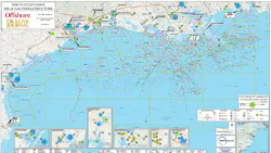
EndeavorB2B’s MAPSearch and the Offshore editorial team produced the 2026 US Gulf Coast Oil & Gas Infrastructure map for readers across the Offshore and Oil & Gas Journal brands, which serves as a useful resource for industry analysis, planning, and understanding of the Gulf Coast's role in energy production and transportation.
All of the following are included and can be identified in the legends in the bottom margin:
- Active, under construction and idle Gulf Coast natural gas and crude oil pipelines labeled by operator and diameter.
- Active offshore oil and gas platform locations.
- Active, under construction and proposed LNG plants numbered by names and operators.
- Active and proposed CCS project injection sites numbered by names and locations and labeled by CO2 capacity in metric tons/year.
- Active CO2 pipelines labeled by operator and diameter.
- Major fabrication yard numbered by names and locations.
- Major port names and locations.
- Major heliport numbered by names and locations.
In addition, there is an inset for the LNG terminals on the East Coast as well as five for major hubs along the Gulf in Corpus Christi, Houston, Lake Charles, Morgan City/Amelia, Houma, and Donaldsville/St. James.
Click the Download button below and click on the link to view the map in full detail. The high‑resolution file is print‑ready.