New software improves geological visualization
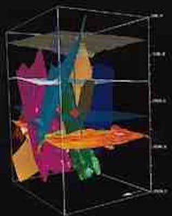
GeoQuest's SurfViz software produced the view on the left of seven faults and four horizons over a 2,500 m interval after being gridded, and truncated by GeoQuest's CPS-3 software. According to GeoQuest, this automated process took only 20 min compared to several hours or days that would have been required previously.
The blue lines show how different well trajectories intersect the faults and horizons. GeoQuest is an operating unit of Schlumberger Inc.
On the right is a visualization produced with Dynamic Graphics Inc.'s new EarthVision software links. These links are to Landmark Graphics Corp.'s OpenWorks software. According to Dynamic Graphics, the new links will ease importing interpreted seismic and petrophysical data to EarthVision geospatial modeling software for enhancing reservoir characterization and 3D well planning activities.
Dynamic Graphics plans to add direct links to well data and interpreted horizon and fault data with a future capability of moving EarthVision models back to Landmark systems and importing 3D seismic data to be viewed with EarthVision models.
Copyright 1997 Oil & Gas Journal. All Rights Reserved.
