New rotating magnet ranging systems useful in oil sands, CBM developments
Rotating magnet ranging (RMR) is the one of the latest technologies used in development drilling for coalbed methane and oil sands. Tools developed over the last 25 years by Vector Magnetics LLC, Ithaca, NY, enable highly accurate electromagnetic downhole proximity measurements.
Magnetic ranging methods quantify the distance between a magnetic source and detector. They are generally more precise than conventional gyro or MWD tools, and are thus used in projects with tight constraints, requiring maximum possible accuracy. Drillers routinely use magnetic ranging to guide horizontal wells to intersect vertical wells.
Passive methods
Passive magnetic systems measure changes in the earth's magnetic flux (earth field, or E-field).
Initially, single-shot magnetic surveys in directional drilling measured inclination and direction in directional drilling. The survey instrument measured magnetic north and needed to be centered in open hole or in a nonmagnetic drill collar. A higher angle borehole and shorter distance to magnetic north required more nonmagnetic collars.
Shell Oil Co. first used single-shot passive magnetic ranging in 1972. It involved magnetizing the casing or liner of an existing wellbore and running detection equipment on a directional tool string.
To establish the relative positioning, the magnitude and direction of the magnetic field were measured at several positions along the wellbore. After compensating for the earth field, the operator could then determine the position and orientation of the wellbore.
Passive ranging requires less equipment and doesn't require access to a second well. But there are several disadvantages:
- The survey instruments need to be placed adjacent to casing collars to be effective.
- The range of accuracy is limited.
- The magnetic field varies in strength over time.
- The method requires several gyroscope runs to confirm the magnetic measurements.
Gyroscopic tools maintain a fixed orientation (oriented to true north) and are not affected by magnetic fields. However, as gyroscopes are reduced in size to fit inside drill strings, the accuracy is reduced and the drift increases.
Passive magnetic ranging is available in several commercial offerings; it is used for drilling parallel well pairs, collision avoidance, wellbore interception, and well recovery.
MagTraC is one such MWD-based system from Scientific Drilling International, Houston. The company says that a 95/8-in. casing string typically produces a measurable magnetic interference of about 50 ft.
Vector Magnetics developed its Wellspot tools to alleviate blowouts. The tools measure and report distance and direction to a target using both passive magnetic and active electromagnetic methods (OGJ, Dec. 21, 1992, p. 96).
Active systems
Active magnetic systems induce a magnetic field in various ways and measure changes in inductance.
Vector Magnetics developed a useful technique for electromagnetic downhole proximity measurement. The company's magnetic guidance tool (MGT) technology uses a downhole electromagnetic source that is deployed in a reference well to enable drilling a second well at a controlled separation.1 The technology was licensed to Sperry-Sun Drilling Services in Canada around 1993, according to Vector Magnetics CEO Arthur Kuckes.
The MGT is placed in the initial (target) well, transmitting an electromagnetic field. The EM field is measured by an MWD probe carried in a sub about 9-15 m behind the bit in a second well. This tool measures separation accurately within 20 m. Although this technology has been widely used for drilling hundreds of wells over the past decade, the distance of the tool behind the bit created problems in directional control.
Rotating magnet ranging
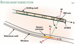
The rotating magnet ranging system (RMRS) reverses the location of source and receiver from the MGT configuration. With RMRS, a set of permanent, rare earth magnets are housed in a short sub immediately behind the bit, and the sub rotates with the bit, creating a time-varying magnetic field. The magnetic dipole moment (M) rotates about an axis (s) normal to the bit face (Fig. 1). This operates within the normal range of drilling parameters, 60-400 rpm.
null
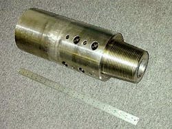
The magnets are cookie-shaped disks, about 1-in. diameter, and they are layered in pockets drilled into the RMRS sub (Fig. 2). Subs are offered in various diameters, from 12-18-in. long.
The sensor package is carried by wireline in a previously drilled well, propelled by a swab cup. A 48-in.-long beryllium-copper housing (strong, hard, non-magnetic) protects the electronics. The sensor package contains a three-component AC magnetometer to measure the time-varying magnetic field (H, Fig. 1), a three-component accelerometer to measure gravity, and a DC magnetometer to measure the earth's static magnetic field.
This system has various advantages over MGT systems. Most importantly, RMR systems are easier for drillers to work with, since the sub is carried immediately behind the bit. RMR provides steering information to drillers in real-time.
The range of RMRS is about 50 m in open hole and 15-20 m inside tubing or casing, with a precision of 0.25 m at 10 m range.2 The inclination at bit is accurate to within 1°. The existing tool is limited to temperatures less than 85° C. Considering its current application in shallow coalbed methane development and oilsands, this has not yet proven to be a significant limitation.
Kuckes told OGJ that the RMRS has had no failures, and the quality is comparable to MGT data.
Oil sands
PanCanadian Petroleum Ltd. first used a rotating magnet ranging system to drill in the Senlac field, Sask., in May 2001. The company compared MGT and RMR systems and noted the increased efficiency of the RMR system. Calgary-based EnCana Corp. has continued using the technology following the merger of PanCanadian with Alberta Energy Company Ltd. (OGJ Online, Jan. 28, 2002).
EnCana has been focusing efforts on its Foster Creek and Christina Lake steam-assisted gravity drainage (SAGD) Athabasca oil sands projects. The SAGD process involves drilling a pair of horizontal wells into an oil sand, injecting steam into the upper well, and producing heated bitumen from the lower well. Petro-Canada's MacKay River SAGD project was the largest in Canada, with 25 initial well pairs (OGJ, Nov. 11, 2002, p. 55).
RMRS is used to drill pairs of horizontal lateral well bores for the SAGD process. The lower (producer) well is drilled first. The bit carries the RMRS sub while drilling the upper (injector) well to position it accurately.
President and CEO Gwyn Morgan told OGJ that EnCana plans to make the Alberta SAGD projects the most cost-effective in the oil sands industry (OGJ, Apr. 21, 2003, p. 31).
The Foster Creek thermal recovery project was started in 1997 and became fully operational in Fall 2001, producing about 24,000 b/d as of September 2003. The Christina Lake thermal project in northeast Alberta was producing about 5,300 b/d (up from 3,300 b/d in early 2003) from three SAGD well pairs.3 A fourth well pair was drilled in late 2003. EnCana will drill 20 more SAGD wells in 2004, part of the 200 wells stipulated in the 5-year plan for 2003-07.
Coalbed methane
Privately held CDX Gas LLC, Dallas, has developed a proprietary drilling technique for CBM incorporating RMRS technology. The company's Z-pinnate horizontal drilling and completion system relies on RMRS for accurate spacing of multiple parallel horizontal wells. The pinnate wellbore design requires a minimal surface footprint and can drain up to 1,200 acres from a single wellsite.
CDX formed its own drilling company, CDX –DART Drilling & Technology LLC (CDDT), and has assembled a fleet of 10 purpose-built rigs as of January 2004. CDX's Doug Wight told OGJ that CDDT planned to acquire and refurbish 10 more top-drive single rigs by the end of 2004 and increase personnel from 150 to 336.
Pipeline project
Anadarko Petroleum Corp.'s Buckinghorse River gorge underground pipeline project also plans to utilize the rotating magnet ranging system (OGJ, Jan. 5, 2004, p. 28). Two horizontal wells will be drilled on opposite sides of the gorge, 1.8 miles apart, using two conventional triple rigs from Precision Drilling Corp. The primary well was spud in December 2003.
Halliburton's Sperry-Sun is contracted for the directional drilling and will use conventional wellbore surveying (standard MWD) to bring the two boreholes within 10-15 m of each other. Sperry Sun's Calgary-based planning engineer, Barry Ryan, told OGJ that the second (intersect) well would spud in mid to late February. Sperry-Sun will confirm the MWD measurements with high-accuracy continuous gyro.
Rahn Pitzer, president of Vector Magnetics, told OGJ that the intersection work would probably begin in early March. At that time, the rotating magnet sub will be used behind the bit to make the final connection.
Construction applications
Tools and technology developed for the oil and gas industry often have crossover applications. Vector Magnetics recently demonstrated a new magnetic tool at the Underground Construction Technology Conference in Houston last month. The conference featured technical sessions on horizontal directional drilling (HDD), microtunneling, and a three-part trenchless technical symposium incorporating HDD.
The magnetic beacon tracker system was successfully used for three HDD projects to install various types of conduits beneath existing infrastructure in 2003. One of two projects in France involved drainage conduits and a pipeline installation in Albany, NY, required navigation beneath a railway, interstate, and a river.
GE's Austin-based Tensor division (previously Honeywell) offers the Tru-Tracker directional steering system that has been used for years for civil engineering work, such as underground construction projects. Tensor's downhole magnetic steering tool senses a magnetic field induced on the surface by Tru-Tracker's electric cables, positioned over the borehole. The DC system measures the E-field using an ordinary magnetic compass.
References
1.Kuckes, Arthur F., Hay, R.T., and McMann, Joe, et al., "New Electromagnetic Surveying/Ranging Method for Drilling Parallel Horizontal Twin Wells," IADC/SPE Drilling Conference, Dallas, Feb. 15-18, 1994.
2.Nekut, Anthony G., Kuckes, Arthur F., and Pitzer, Rahn G., "Rotating magnet ranging—a new drilling guidance technology," Eighth 1-day conference on horizontal well technology, Canadian sections SPE and Petroleum Society, Calgary, Nov. 7, 2001.
3.Hollies, Doug, "Second generation of directional tools used to drill SAGD well pairs at Foster Creek and Christina Lake," CADE/CAODC Drilling Conference, Calgary, Oct. 21, 2003.