Ocean-bottom seismographs improve data resolution offshore Australia
Tayvis Dunnahoe
Exploration Editor
Ocean-bottom seismic (OBS) has emerged in recent years as a mainstream offshore exploration technique. Operators have benefitted from supplementing conventional surveys with OBS data. AuScope Ltd. invested in a fleet of ocean-bottom seismographs (OBSs) that are maintained by Australia's national geological survey to aid in mapping its offshore territories.
A project is planned to investigate nearshore gas deposits off New South Wales on Australia's East Coast using OBS as a cost-effective method for supplementing conventional seismic acquisition in a shallow water environment.
Fleet response
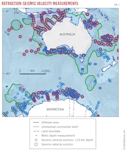
The Australian marine jurisdiction is the third largest in the world and nearly twice the size of the continent's land mass. "Existing refraction seismic studies have poor coverage over Australia's marine jurisdiction, and some parts of the Australian Antarctic Territory are better covered than the mainland by such measurements," said Alexey Goncharov, principal scientist at Geoscience Australia (Fig. 1).

Refraction seismic studies require seismic signals be recorded at much larger shot-receiver offsets than are conventionally used in reflection (streamer) surveys. The Australian National OBS Fleet was created to improve seismic velocity coverage in deep-crust settings. Constraining subsidence and hydrocarbon maturation modeling both require crustal thickness measurements and petrological composition information, which are difficult to obtain from reflection data.
Better seismic velocities than those derived from conventional streamers are also needed for both prestack depth migration and depth conversion of reflection data, particularly in the deeper crust. "These drivers motivated our industry partners to support the establishment of the fleet," Goncharov said.
The Australian National OBS Fleet is part of AuScope's Australian Geophysical Observing System (AGOS), an initiative of the Australian government funded through the Education Investment Fund. Instruments were delivered by the manufacturer, Guralp Systems Ltd. (UK), in late 2013. Shell Australia and Woodside funded the OBS acceptance trials and inaugural deployments in 2014-15.
Parameters, capabilities
The OBS units can withstand depths to 6,000 m. Each has four-channel recording with a maximum 1,000-samples/sec (sps) frequency and on-board flash memory capable of up to 12-month continuous recording.
AuScope OBSs have a broadband flat frequency response from 0.0167 hz to 100 hz. According to Goncharov, only five or six institutions globally have broadband OBSs (BBOBS). The broadband capability allows the instruments to record both passive-source (earthquakes, ambient noise) and active -source (airgun-generated) seismic data.
"This broadband capability has come at the right time, as the petroleum industry and geophysical companies are more commonly using broadband airgun arrays as sources of seismic energy to improve resolution of subsurface reflection seismic imagery," said Goncharov.
The more commonly used OBSs, so called short-period instruments, have frequency-pass bands starting at 4.5 hz. Geoscience Australia's first experiments with BBOBSs proved that broadband airgun arrays with moderate (by refraction seismic standards) volumes of 4,630 cu in. were sufficiently strong to generate recordable signals at large (tens of km) offsets.
OBS data collected during commercial seismic surveys in Australian territorial waters in 2014-15 proved it is possible to comprehensively image crust and upper-mantle velocity distributions from analysis of reflected and refracted phases generated by an industry-standard broadband airgun array. "This means that valuable pre-competitive information on a regional scale can be obtained as a by-product of commercial seismic surveys," Goncharov said.
At a rate of 100 sps, data can be recorded by the AuScope OBSs continuously for 12 months. After that the battery powering the digitizer will be exhausted. "There is no sense in leaving an instrument on the seafloor for a long period of time after that," Goncharov explained. "However, if the logistics of the experiment preclude recovery immediately after the exhaustion of the digitizer battery, the instrument can stay on the seafloor longer." The release mechanism is powered by a different battery than the digitizer.
OBSs are pinged from several directions immediately after they have settled on the seafloor to define the exact location at which data will be recorded. That location generally differs from the deployment location on the sea surface, particularly if ocean currents are strong. The instrument descends to the sea floor at a rate of about 40 m/min. "At a depth of 2,400 m-our deepest commercial survey deployment so far-it takes approximately 1 hr for an instrument to reach the sea floor," Goncharov said.
OBSs can record data simultaneously with conventional seismic acquisition, in either 2D or 3D. The ability to eavesdrop on conventional shoots is an efficient and cost effective way to supplement conventional seismic acquisition. This process can also radically increase the data recording aperture from a maximum of several kilometers on streamers to possibly in excess of 100 km, depending on airgun array volume and configuration.
OBSs can also be used on stand-alone deployments for passive data recording, including monitoring microseismicity induced by reservoir depletion.
Conventional comparison
Conventional hydrophones in streamers towed behind a seismic vessel are pressure sensors. "They are omnidirectional, which means they cannot detect the direction from which seismic energy arrives," Goncharov explained. AuScope's broadband OBSs have a 3-component seismometer as well as a hydrophone (flat frequency response from 2 hz to 30 khz).
Multicomponent recording of the seismic signal detects the direction of the seismic energy arrival. On the vertical component of the seismometer, the down-going wave field displays differently than the up-going wave field. "Summing the pressure [hydrophone data] and vertical geophone data means we can reduce the effects of ghosts and water column reverberations in seismic data acquired on the seafloor," said Goncharov.
Methods based on the separation of up-going and down-going elastic wave fields from the geophone and hydrophone data can provide efficient noise rejection and amplitude preservation in the summed data. These directly translate into higher resolution of seismic data, which is essential for future exploration.
S-wave detection
Compressional waves (P-waves) recorded during conventional marine surveys by hydrophones in streamers towed behind seismic vessels are mechanical waves that propagate through the interior of the material as pressure fluctuations. A characteristic of longitudinal waves, according to Goncharov, is that the motion of the particles goes back and forth in the same direction the wave travels. Three types of mechanical waves will propagate through solid material:
• Shear waves.
• Rayleigh waves.
• Love waves.
Similar to compressional waves, shear waves (S-waves) travel through the interior of the material; both are known as body waves. Rayleigh and Love waves travel along the surface of a solid material.
Shear waves depend on elastic deformation of the medium in a direction that is perpendicular to propagation. "Although most reflection surveys are based on analysis of pressure waves, seismic sources generate all types of waves in the seabed," Goncharov said. The various wave types are separated by their differences in propagation velocity. "Fluids, such as water, cannot sustain a shear deformation," he added. Only compressional waves propagate through air or water."
At the water-solid interface, however, new wave types will be generated through energy conversion, and both shear and surface waves will be present in marine seismic surveys. "But these cannot be recorded on a streamer towed in water," Goncharov said. OBS that is coupled with the seafloor will record them on all three components of the seismometer. "This is the fundamental difference between OBS recording on the seafloor and a hydrophone recording on streamer near the water surface."
Goncharov added, "Derivative shear waves, or to be more precise, SP-conversions that originate at the seafloor on the way back to streamer receivers, are present in the streamer data but are unlikely to be identifiable." But converted-wave seismic exploration based on multicomponent seismic recording captures these data and is increasing in its application.
"S-wave analysis makes it easier to identify the elastic moduli of the rock, fluid type, and degree of saturation, all of which are important for the oil and gas industry," he said. Interpretations using only P-waves do not always adequately image a reservoir or describe its properties. Rocks differing in saturants can have a similar P-wave response or some interfaces may have low P-wave contrast. "S-wave properties may vary more, and along with the P-wave properties, can help characterize the rock structure, type, and fluids within," Goncharov said.
Project planning
On the East Coast of Australia, soaring gas prices due to a cold snap and rising demand from Queensland LNG projects triggered a winter energy crisis. "Wholesale gas prices in Sydney in early July 2016 reached almost $29 per gigajoule, which was almost 60% higher than their [previous] peak in 2012," said David Breeze, executive director at Advent Energy Ltd. Domestic industrial gas buyers were paying more than three times as much as Japan was paying for imported LNG.
"OBSs have come to our attention recently in Australia as potentially providing a reduced-noise seismic signal," Breeze said. The operator is investigating the application of OBS in conjunction with surface-towed seismic over its Baleen prospect.
The Baleen prospect in PEP11 is in 125 m of water in the offshore Sydney basin 30 km south-southeast of Newcastle. Initial reserves estimates by previous permit holders identified 1 tcf of gas. "This was at a time when the cheap prevalence of coal in the region limited the viability of offshore gas exploration," Breeze said.
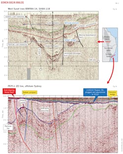
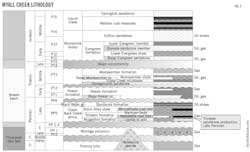
Recent interpretation of all available data has demonstrated that the Baleen prospect exhibits numerous analogies with producing fields onshore in the Bowen-Sydney superbasin (Fig. 2 and 3) and is ideally situated adjacent to the Newcastle syncline sedimentary sink-source kitchen.
New Seaclem-1 is the only well drilled in the offshore Sydney basin. It targeted Tertiary sand above the regional Cainozoic unconformity. The well slightly penetrated the pre-Cainozoic unconformity Permian-Triassic sequence. "The offshore Sydney basin suffers from complex geophysical conditions, including a hard seabed and an eastward dipping and rugose Cainozoic unconformity approaching the surface in the west of PEP11," Breeze said.

These features result in rapid signal degradation and a severe problem with multiples. OBS deployment in conjunction with surface-towed streamers is expected to allow geohazard determination for drilling safety. Advent Energy also hopes to:
• Improve velocity models for the offshore Sydney basin.
• Image immediately below the regional unconformity.
• Identify 3D imaging of direct or indirect hydrocarbon indicators.
• Possibly image deeper structures.
The OBS component of the seismic program is still in the planning phase, though Advent Energy believes its project will be a novel application of the technology. "Application may include shallow geological and geophysical investigation for overburden integrity analysis-via multichannel analysis of surface waves-and shallow gas hazard identification," Breeze said.

The primary target at Baleen is 2,150 m below the seafloor. Two-dimensional seismic data show that the Permian-aged section of the onshore Bowen basin has conventional gas fields at similar time and depth to PEP11 at the Triassic-Permian age boundary with a similar seismic amplitude strength on regional 2D to PEP11 (Fig. 4 and 5).
Final project design has yet to occur. But if the outcome is successful it could demonstrate the viability of OBS applications in untested regions. "If we are successful in identifying any or all of the objectives outlined above, then geotechnical derisking, improved drilling tolerances, and heightened prospectivity may be achieved," Breeze said.
Once the company has concluded acquisition and interpretation, it plans to evaluate securing a suitable rig to take advantage of the current market conditions.
Advanced acquisition
To date AuScope's OBS fleet has recorded high-quailty data at each of its deployment sites, often including offsets sufficiently large to detect possible Pn phases, refractions from the upper mantle. Such information allows determining both crustal thickness and seismic velocity distribution to the Moho discontinuity, providing important constraints for subsidence and hydrocarbon maturation modeling.
The Moho, or Mohorovicic, discontinuity is a seismic boundary where velocity of seismic waves exceeds approximately 8 km/sec. In most cases it is rather easy to map from refraction seismic data recorded at large (several tens of kilometers) source-receiver offsets. Sometimes, however, this discontinuity is difficult to identify using "conventional reflection data because often there are a number of competing strong and discontinuous reflections in the lower crust that can be interpreted as the Moho," Goncharov said. Conventional reflection technology struggles to get good seismic velocity resolution in the deep crust.
The Moho is generally interpreted as the boundary between crustal felsic-mafic rocks and upper mantle ultra-mafic peridotites. "It is fair to say that the Moho is becoming widely recognized by the petroleum industry as one of the key parameters that define heat flow affecting hydrocarbon maturation in sedimentary basins," Goncharov said.
Geoscience Australia has also undertaken research examining the interaction between anthropogenic signals (airgun source, vessel noise) and the natural environment. Earthquake data have been recorded by AuScope OBSs during marine seismic surveys. "Surprisingly, the earthquake energy appears to make a noticeable addition to airgun generated energy not only near the microseismic peak frequencies generated by the ocean (~0.15 hz or less), but also up to frequencies as high as 50-60 hz," Goncharov said.
These frequencies are in the middle of the passband for conventional petroleum-oriented marine reflection surveys. As a result, there may be some distortion in attribute analysis and other refined techniques used for oil and gas seismic data interpretation. "OBS data suggest that not all recordings that come to the streamer on a marine reflection survey come from airguns," Goncharov said.
"The biggest advantage of using earthquake events as a passive source in offshore seismic exploration at this stage is that these techniques are a less expensive method to obtain certain seismic information, such as the crustal thickness discussed above," Goncharov said. He added that passive source techniques like receiver-function analysis need further work, and benchmarking against active-source techniques, to be accepted as valid tools for oil and gas exploration. "We have already begun recording earthquake and airgun signals at fixed locations, and this opens up a range of possibilities for calibration and comparison of those signal strengths and spectral compositions."
The OBS Access Committee received an application to use AuScope instruments for a 12-month deployment in the Roebuck basin on the Australian NW Margin starting in 2017. The project is targeted at passive recording (earthquake energy, ambient noise). "If the petroleum company or geophysical contractor shoots an airgun line over the instruments while they are deployed on that survey, this would be an excellent opportunity to benchmark results of passive source recording against those derived from active source data," Goncharov said.
Future potential
OBS technology presents advantages in a number of areas. AuScope OBSs are broadband instruments and allow passive and active source data recording at the same, or proximal locations, which is finding appeal for calibration-benchmarking of results. "The first results of such combined experiments undertaken in 2014-15 are already available to researchers through Geoscience Australia," Goncharov said. He adds that recording active-source seismic reflection, wide-angle/refraction, and passive data at coincident or proximal locations should be a long-term goal.
OBS time-lapse (4D) monitor surveys are already a reality, with the Gulf of Mexico's Atlantis field as one example. While the logistics of such experiments are complicated, potential remains for recording and processing horizontal component seismometer data in such surveys in addition to vertical component data, significantly improving information on fluid saturation of the rock, according to Goncharov.
Combined onshore-offshore experiments with signals from sources on land recorded on the seafloor, supplemented by marine airgun signals recorded by land stations, have occured in the Gulf of Mexico and the Arctic Coast of East Siberia. "Such acquisition design allows seismic ray coverage through the coastal transition zone in both directions, and all the powers of reciprocal analysis become available," Goncharov said.
Broader OBS technology applications relative to 2D and 3D reflection surveys are generated by the large source-receiver offsets inherent to OBS recording. Refracted and reflected phases can be recorded and analyzed in OBS data rather than just reflected in streamer surveys. Multicomponent OBS data also display and make available for analysis more types of recorded seismic energy, such as shear waves and converted waves.