Small Advances Yield Big Improvements In Seismic Images From Difficult Areas

Tom Nickoloff, Jim Manatt
Providence Technologies Inc.
Roswell, N.M.
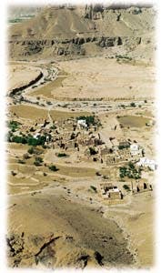
Rugged terrain in the Masila Block of Yemen includes plateaus and wadis with elevation changes as great as 900 ft. This village is in Wadi Sunah. The difficult surface conditions create problems similar to those seismic survey designers face in the Val Verde basin, a view of which appears on the magazine cover (Fig. 1).Difficult areas for exploration present opportunity to see what has not been seen before, make new plays, and find new reserves by solving signal-to-noise, imaging, sampling, and logistical problems. Problem-solving in difficult areas tends to focus upon deriving incremental benefits achieved through compartmentalization of the process and sometimes through rethinking of the fundamentals.
Breakthroughs, in the seismic sense, are seldom the result of a single step or parameter and are more often the result of a well-calibrated and complete process, from planning through final processing. While we continue to seek the dramatic breakthroughs, seismic imaging advancements in difficult areas more typically come little-by-little.
Problems
An initial step towards compartmentalizing problems associated with difficult areas is to characterize subsurface versus surface/near-surface difficulties. Subsurface challenges-complex geologies like overthrusts or subsalt structures, for example-are generally characterized by distorted seismic signal travel paths and can be found onshore and offshore in relatively equal abundance.These challenges are typically met with higher fold, finer sampling, and more complete distribution of shot and receiver offsets, which facilitate powerful processing algorithms. Today's high channel, broad dynamic range acquisition systems make it possible. The key hurdles to meeting optimum parameters often arise from the surface or near-surface.
Surface and near-surface challenges to seismic exploration are found in abundance onshore in the form of rugged terrain, coherent noise, and statics problems, both long and short. The offshore can present its own set of problems generally associated with multiples and, in some cases of marine acquisition over ancestral shorelines, near-surface static problems similar to the onshore. Offshore seismic data tend to be of a higher quality than onshore data. In general, enhancing the bandwidth of onshore seismic data is an ever-present challenge to geophysicists.
Rugged terrain is well illustrated by the mesa/valley terrain of the Edwards Plateau overlying the prolific Val Verde basin of West Texas and the plateau/wadi terrain of the even more prolific Masila Block, Republic of Yemen, which provide the project and data examples for this article (Fig. 1).
Logistics and noise
Rugged terrain affects high resolution seismic imaging efforts in two fundamental ways. First, there are nontrivial operating issues that relate to the logistics of moving hundreds or thousands of receiver groups, MRX boxes, miles of cable and geophones, drills, and dynamite, not to mention the people and communications needed to make precise, accurate placements of this materiel, then to actually record seismic signal in remote terrain.Less obvious are the learning experiences that can incrementally improve the overall field effort, such as minimizing source and receiver skips for 3D and maintaining receiver groups on common elevation and rock outcrop.
These issues overlap the second realm of technical challenges on rugged terrain, the special effects of rough surfaces on efforts to record seismic signal versus seismic noise. The general direction of seismic imaging has been toward point-source, point-receiver geometry for maximum frequency and resolution; in rugged areas pragmatic dedication to receiving usable signal steers acquisition and processing designs in the opposite direction, toward sufficient source and receiver arrays to attack noise events in such situations.
From a seismic perspective, loosely consolidated soils or fill tend to be slower velocity than exposed bare rock or bedrock covered by a thin veneer of soil. The geophysical significance of this is the amount and strength of the noise generated during seismic acquisition. This noise which travels laterally is called "coherent" or "source-generated" noise, and comes in many varieties. Some of the more common and infamous noise is referred to as groundroll, direct wave, and head waves.
In general, a slower velocity surface and near-surface generates lower amplitude coherent noise than does a harder and faster surface, which can create significant, high amplitude coherent noise, significant in that it is much greater than the desired signal and can effectively mask subsurface images. The hard, high velocity limestones such as those on the surface of much of the Val Verde basin and Masila Block, Yemen, generate this significant coherent noise. They are referred to as being "high Q" ("Q" being the propensity to ring, the inverse of absorption).
Many basalt surfaces also represent high velocity, high Q cover that can frustrate conventional seismic exploration. When such a surface is seismically disturbed with a vibrator or a dynamite shot in order to acquire desired, reflected signal from possibly economic subsurface targets, a paradox arises: The same energy initiates the undesired source-generated noise problem.
Seismic signal is necessary to generate a reflection from target horizons. An important distinction between seismic signal and source-generated noise is that signal travels spherically while coherent noise travels circularly. Since it is easy to envision that a sphere has considerable surface area, it is easy to envision that seismic signal energy is dissipated or absorbed much quicker than noise energy traveling along the perimeter of a circle. The significance of this is that if we do nothing physically to address this disparity with acquisition parameters, most often with areal geophone arrays, the coherent noise is bound to dominate signal.
When considering this relationship between signal and coherent noise, it is important to consider not only the coherent noise traveling along the seismic traverse, but the same coherent noise which is traveling laterally to a nearby mesa edge or plateau boundary, reflecting back across the receiver detectors. On high velocity, high Q surfaces such as the mesas of the Val Verde and the plateaus of Yemen, this "backscattered" noise, as it is often called, reaches the receiver detectors before much of the desired, reflected signal energy returns from the subsurface target horizon.
A mesa edge can be thought of as comprising a series of points, each a potential initiator of backscattered coherent noise. The backscattered and laterally traveling source-generated noise produces an undesired hash of noise, which dominates the desired reflections from target horizons, masking resolution of imaging targets, hydrocarbon traps, and reservoirs (Fig. 2 [190,440]).
One important aspect of solving the noise problem involves designing arrays of seismic detectors, which act as an antenna, tuned to record the signal and attenuate noise. However, array design is not enough, and considerable additional benefit can be gained through design and implementation of unique field geometries.
The use of designed receiver arrays has long been recognized as critical to addressing the coherent noise and backscatter problem. More recently, incremental advances in acquisition and processing techniques have contributed to the solution.
Broad dynamic range recording systems, for example, allow a greater amount of signal to be sampled and distinguished from coherent noise. Also, more-powerful processing algorithms, creative array analysis, and engineered acquisition geometries have improved imaging in difficult areas. Growth in the number of channels used in recording, 3D onshore recording systems, and innovative treatments of subsurface sampling, fold, and offset issues have made solutions practical.
Coupled with modern hardware advancements, these incremental gains have enabled the oil and gas industry to search for and find significant, previously unseen oil and gas reserves in difficult areas of mature provinces like North America and promising, less-explored provinces like the Masila Block of Yemen.
Val Verde developments
In the Val Verde basin, three giant gas structures, Puckett, Grey Ranch, and Brown Bassett fields, were discovered by major oil companies in the 1950s and 1960s. The discoveries were based primarily on subsurface mapping of structural closures along major regional fault lineaments, weakly supported by occasional glimpses from poor quality 2D seismic reflection or refraction data.The giants have produced some 13 tcf of gas so far, with estimated ultimate recoveries of 20 tcf, from deep (14,000 ft) Ordovician Ellenburger carbonates.
The Ouachita thrustbelt has long been known to be present south of the giant foreland fields but has not developed into a major producing horizon, partly due to its complexity (Fig. 3 [81,561 bytes]). Smaller but economic gas production was discovered during exploration for the giants and continues to produce in relatively shallow (1,500-7,000 ft) thrusts at Pinon, Thistle, and McKay Creek fields.
A 1993 discovery by Tom Brown Inc. of Midland and Conoco Inc. of a previously unresolved, unknown Strawn-age thrusted carbonate, just forward of the Ouachita front, ended a long search for a significant new success.
Relatively low channel 2D seismic crews, with 120 channels or less, were the only available systems for seismic exploration in the Val Verde basin through the late 1980s. The advent of higher channel, broad dynamic range recording systems, the first commercial generation of 3D systems with the capability to record as many as 720 channels live on the ground for a single shot, enabled geophysicists to better sample complex problems such as source-generated noise, its backscattered counterpart, and overthrust dips.
Early multireceiver line tests in 1989 deliberately oversampled the problem in order to allow for robust noise analysis and evaluation of threshold measurements of fold and sampling requirements needed to properly image the subsurface targets. The ability to see and measure this seismic behavior enabled geophysicists to design, engineer, test, and prove field receiver and source geometries that effectively attack and help attenuate such problems in the field.
The first commercial applications came in the form of 2D swath techniques. Additional parameter evaluation and modification led to ongoing 3D programs. By carefully extrapolating the lessons from the 2D swath and initial tests, geophysicists were able to design multidirectional receiver arrays, unique field geometries, and resultant, more-powerful processing algorithms with which to produce high quality 3D images (Fig. 4 [111,711 bytes]).
Solutions
These seismic imaging improvements yielded new geologic models, now well documented in the literature, for the basin and led Conoco geoscientists to interpret thrusted beds considerably farther north than previously thought along the Ouachita thrustbelt. Conoco partner Tom Brown announced in early 1993 the ACU 1-49 thrusted Strawn discovery in Terrell County, Tex., with initial flow rates over 14 MMcfd and 300 b/d of condensate at a depth of some 10,000 ft.The Strawn play continues in exploration and development, supported by new discoveries in allocthonus Permo-Pennsylvanian gas sands. Today, along with Conoco and Tom Brown, Chevron, Mobil, ARCO, Union Pacific Resources, J. Cleo Thompson, Rio-Tex, Enron, Hunt Oil, Hunt Energy, and others successfully drill and shoot 3D seismic over this once poor seismic province (Fig. 5 [74,332 bytes]).
Providence Technologies designed, managed, and delivered some 125 sq miles of intensely sampled, advanced 3D seismic group shoot data in 1995-96, connecting major oil company 3D programs between Brown Basset field and the Strawn ACU discovery along the thrust front. Providence continues to enhance resolution of the complex Strawn thrust through experimental depth migration as part of a research project with Sandia National Labs and industry partners. The company has also recently completed experimental high resolution seismic tests in Brown Basset field for ARCO and continues to develop 3D programs in the play.
An estimated 150 wells have been drilled in the trend since the Tom Brown/Conoco discovery, with a drilling success rate of 50%, a dramatic success given the complexity.
The Masila Block
Masila Block 14-A in Yemen provides similar opportunities for the industry to record a seismic imaging breakthrough on the basis of many incremental gains.Canadian Occidental (CanOxy) declared the block commercial in 1991 and started production from it in 1993. In the second quarter of 1997, the Masila fields yielded a mean of 189,400 b/d of oil, 98,500 b/d net to the company.
Unlike in the Val Verde basin, traditional imaging targets in the Masila Block are relatively subtle, not thrusted but complexly overprinted by faulting, and have a stratigraphic component. Successful resolution of these imaging objectives requires broad bandwidth, high quality reflected signal.
The morphology of the block is similar to that of the Val Verde mesas and valleys, with several exceptions. First, the magnitude of the topography is several times greater, with the Tertiary Umm Er Radhuma plateau cliffs often exceeding 250 m. In addition, there exist remnant jebels of Jeza shale on top of these plateaus, with very steep skree-like slopes which must be cut with bulldozers to allow vehicular access.
Further, and not unexpectedly, the area is very arid, with flash-flooding during the spring rainy season. In addition to the obvious hazards to equipment and personnel, this rapid movement of water, coupled with scorching surface temperatures, has strewn the wadis, plateaus, and jebels with golfball to soccerball sized, sharp, angular, erosional rock remnants. It is not uncommon for vehicles to be equipped with 16 ply tires; mechanical and tire repairs are among a seismic crew's most critical operations.
These challenges require thorough planning, judicious use of bulldozers, and use of combined heliportable and ground vehicle operations, including surveying, drilling, layout, and recording. The key to success was adaptation of lessons from the Val Verde basin, both geophysical and operational, to the extreme conditions of the Masila Block.
Masila seismic
CanOxy and its partners, Consolidated Contractors International, Occidental International E&P, and Pecten Yemen Masila Co., conducted their first 3D seismic programs on the block in 1995 (Fig. 6 [470,341 bytes]). Although initial results were discouraging, geophysicists were able to analyze the 1995 3D volumes and, with input and insight from the Val Verde, to reassess project goals, parameters, and implementation.CanOxy discovered a new play in zones deeper than the Cretaceous Qishn clastic carbonate at its Sunah field which supplemented the already significant Qishn play. Unlike the Qishn reservoirs, which in general are gentle faulted structures, the deeper reservoirs underlie very high impedance Sarr and Naifa carbonates in half graben geometry, requiring the imaging of steeper dips, deep fault patterns, the basement, and stratigraphic thinning.
While the 1995 Sunah 3D seismic survey data recovered spotty images of the Qishn, images of the new pay raised questions as to whether the deeper formation could be imaged, given the significant source-generated noise in the area, topography and highly reflective Sarr and Naifa, hypothesized to be an impedance mirror through which the seismic signal would not propagate or reflect.
A distinct anomaly was a key 2D line previously recorded, oriented in dip direction along a large, north-south wadi, which nicely imaged the half graben geometry. Last year, with a Val Verde approach, the 2D and 1995 3D data were reprocessed and analyzed with previous source tests in order to recharacterize the coherent noise effects on signal. Analyses compared the results of varying source and receiver data from plateau-to-plateau and plateau-to-wadi, and vice versa.
Striking similarities to the Val Verde noise components were observed. Speeds of the head waves, direct waves, and groundroll were almost identical, half a planet away, and backscattered energy was apparent in the shot records. Geophysicists recognized that Val Verde-type array and field geometry strategies could be brought to bear on the problem.
Therefore, the goal of the design team became basically threefold. First, the significant coherent source-generated noise and its backscatter had to be addressed, and previous array work had to be tuned to Masila conditions. Next, target depths, sampling requirements, and known source and receiver skips were added to the equation in order to optimize certain parameters, such as azimuth and offset distribution, that would enhance powerful modern 3D processing techniques such as 3D dip moveout (DMO), beam steering, and migration. Finally, the design was to be adaptable and capable of implementation on the rough Masila Block.
Differences that needed to be incorporated in the parameters were the shallower depth of the objectives, the overall higher subsurface average velocity, and the topographic and logistical issues. Source and receiver arrays were set through field startup testing. Charge sizes had to be carefully analyzed because of the variability of surfaces and the natural limitations on use of areal arrays. Crew members compiled an array bible ranking options for various topographic and surface conditions. Several crews painted rocks for each source and receiver array, keeping a detailed log of them all.
Analysis of the placement of contributory source and receiver locations that needed to be offset required several man-weeks of effort. Determining how to achieve best subsurface coverage required several iterations of source and receiver placement along with analysis of fold, offset, and azimuth coverage. Surveys used a combination of conventional, real time kinematic (RTK), and ground positioning satellite (GPS) equipment, often assisted by helicopters in remote locations.
While there was more than four times the total shot and receiver coverage in the 1996 3D surveys than in the 1995 surveys, the analyses and extra effort cut skip percentages for the 1996 Sunah 3D survey, the roughest conducted on the block, to 7-8% for both shots and receivers, compared to nearly twice that in the 1995 Sunah 3D survey. The near trace coverage obtained through this careful implementation was critical to the stabilization of the statics, velocities, and overall imaging.
On several occasions, as many as a dozen infill shots or receivers were flown into hanging valleys where there was no other access from either the wadi floor or from the plateau above. Although expensive and time-consuming, had this effort not been undertaken, serious and critical holes in coverage might have corrupted the survey.
Critical to the overall project was the experience that the seismic contractor, Solid State Geophysical, possessed from prior work in Yemen. Routinely, the contractor draped cable up and down cliffs with over 200 m relief.
The 3D high channel acquisition system used in the survey maintained and recorded 1,250-plus live channels at a time. The need for reliable equipment was illustrated by one particularly onerous receiver line that traversed six deeply cut orthogonal wadis, resulting in 12-13 up or down traverses ranging from 150 to 250 m each.
Defining geometry
Final results from the 1996-97 Sunah 3D survey helped define the geometry of the half graben structures, allowed for pursuit of additional targets, and produced a sharper, broader bandwidth image of the Qishn reservoirs above. Shot concurrently with the 1996 3D program was a 2D swath seismic program primarily for regional definition and additional field delineation. The 1996 2D and 3D project on Masila Block 14-A included approximately 150 sq km of 3D, 150 km of 2D, and 9 km of test lines.Additional drilling opportunities have prompted CanOxy to add a second full-time drilling rig. During first quarter 1997, in part due to 1996 2D swath seismic, CanOxy drilled three delineation wells and successfully expanded the Tawila field. Together, the wells flowed 24,000 b/d of oil, boosting gross field output to 70,000 b/d.
Additional activity has been reported at the Camaal field, site of further 2D swath seismic work in 1996. Drilling at Camaal has yielded three additional wells with expected combined production rates of 18,000-28,000 b/d. The Heijah field, also a site of 1996 3D data activity, and the Sunah field have also reported additional activity.
It was reported in September that an additional 76 million bbl proved reserves net to CanOxy has been provided by production performance, development, and seismic information, boosting total net reserves to 169 million bbl. In addition, reserves life has been extended by 5 years.
CanOxy has announced plans to acquire up to 250 sq km more seismic data coverage in 1997 to further delineate its Masila holdings.
Potential and interest
Improvements to seismic imaging in difficult areas enable companies to extend the limits of resolution with potentially big results.The methods used in the Val Verde basin, for example, can apply to un- or underexplored thrustbelts throughout North America. The onshore overthrust margin incorporates several active wildcat plays including the extensive Canadian Foothills trend along with the producing thrustbelt trends of the Val Verde and Arkoma basins of the Lower 48. More often than not, these plays are poorly imaged due to surface and subsurface problems.
U.S. Geological Survey data suggest there may be 39 tcf of undiscovered gas and 2.2 billion bbl of oil in remote overthrust regions of Alaska-the largest postulated but undiscovered volumes within a discrete onshore trend on the North American continent. Some 5 tcf of gas potential is ascribed to the thrustbelt of the western Green River basin, Wyoming. And thrust trends of unknown potential exist in the Rocky Mountains, Central Texas, Alabama, and the Appalachians all the way to Newfoundland (Fig. 7 [68,326 bytes]).
Results from Yemen's Masila Block show how rethinking the 3D acquisition design and geometry for formidable area-dependent problems can enhance imaging and improve understanding of both proven reservoirs and new exploration opportunities with world class potential. The Masila fields are the most prolific in the country, exceeding the Exxon/Hunt block. Combined production from the Masila fields rose from 171,000 b/d in 1996 to 185,000 b/d in the first quarter of 1997.
Industry interest in difficult imaging problems is evident in the support of nine companies involved in Providence Technologies' Carpathian Thrustbelt Imaging Project, which uses advanced test data from Poland.
Last year, Amoco recorded a robust test seismic dataset over a known, logged, producing thrusted reservoir along the Carpathian thrust front. The test data incorporate a wide line 2D swath profile consisting of 13 receiver lines, for evaluation of in-line and cross-line signal and noise events in thrusted environments.
Providence is conducting advanced data processing tests and diagnostics with subcontractor Golden Geophysical. Companies supporting the project are Amoco, Anadarko, Chevron, Conoco, Exxon, Hunt Oil, Marathon, Oxy, and Talisman Energy. Results and analysis are expected to be completed by the end of 1997.
Acknowledgment
The authors recognize contributions of the project contractors Dawson Geophysical and Solid State Geophysical for data acquisition and Golden Geophysical for data processing. We thank our clients and customers for supporting the work and allowing us to show the data in this article.The Authors
Tom Nickoloff is president and chief geophysicist of Providence Technologies Inc. He specializes in difficult area exploration and seismic imaging analysis, designs, acquisition, and data delivery. He holds a BS in geophysical engineering from Colorado School of Mines.
![(Fig. 2 [190,440])](http://images.pennwellnet.com/ogj/images/ogj2/9544jni02.gif)
![(Fig. 3 [81,561 bytes])](http://images.pennwellnet.com/ogj/images/ogj2/9544jni03.gif)
![(Fig. 4 [111,711 bytes])](http://images.pennwellnet.com/ogj/images/ogj2/9544jni04.gif)
![(Fig. 5 [74,332 bytes])](http://images.pennwellnet.com/ogj/images/ogj2/9544jni05.gif)
![(Fig. 6 [470,341 bytes])](http://images.pennwellnet.com/ogj/images/ogj2/9544jni06.gif)
![(Fig. 7 [68,326 bytes])](http://images.pennwellnet.com/ogj/images/ogj2/9544jni07.gif)
Jim Manatt is chief executive officer of Providence Technologies and focuses on delivery of proprietary and cost-shared services, advanced technology, and high resolution data to customers. He holds a BA from New Mexico State University.
Copyright 1997 Oil & Gas Journal. All Rights Reserved.