Canada's commercially oriented Radarsat returns SAR data for oil, gas exploration
Robert E. Tack
Radarsat International
Vancouver, B.C.
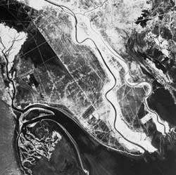
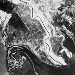
Northwestern Persian Gulf is visible on this standard mode image Radarsat acquired in early 1996. The Tigris and Euphrates rivers flow into the gulf from the north. Drainage channels at lower left are on Bubiyan Island, northeastern Kuwait. Iraq oil fields show as a collection of pipelines and polygonal well sites in the marshy delta area. A small part of Iran is visible at upper right. Image courtesy Canada Centre for Remote Sensing (Fig. 1).
Canada in November 1995 launched the world's first commercially oriented remote sensing satellite to carry a synthetic aperture radar (SAR) imaging system. Radarsat provides the oil and gas industry with a unique variety of exploration and mapping capabilities not previously offered by an operational imaging satellite. Radarsat's SAR data became commercially available in March 1996 at a cost ranging between 2¢ to $1.60/sq km for most products-a fraction of the cost of airborne SAR imagery.
The potential widespread utility of Radarsat data in the petroleum industry results from Radarsat's innovative development as a partnership between private industry and Canadian governments. Input from governmental organizations such as the Canadian Space Agency (CSA) and Canada Centre for Remote Sensing (CCRS) assured the satellite would have extensive applications in the exploration and production of oil and gas-among of Canada's chief exports. Design contributions from participating private organizations guarantee the satellite serves the operational needs of users; this is particularly important in commercial applications.
To provide remote sensing users worldwide with commercial access to Radarsat data, Canada placed data sales, marketing, and distribution functions under the responsibility of Radarsat International (RSI) of Vancouver, B.C., Canada, a private firm formed in 1989 to commercialize the country's rapidly growing remote sensing industry.
Neither Canada nor RSI is a newcomer to commercial remote sensing. For more than 20 years, Canada has downlinked satellite imagery to receiving stations in Gatineau, Que., and Prince Albert, Sask. For the past 6, RSI has handled the product development and distribution of U.S. Landsat, French SPOT, and European ERS data received at those stations. Recently, the company also signed an agreement to distribute Japanese JERS-1 data. RSI is establishing a network of receiving stations and sales agents similar to Landsat and SPOT for global distribution of Radarsat data.
E&P benefits of SAR
Since the early 1970s, SAR imagery has proved valuable in virtually every phase of hydrocarbon recovery from the initial geologic structural assessment and drill site selection to logistics planning and environmental remediation. However, due to the ready availability of optical Landsat and SPOT imagery and the lack of an operationally-oriented radar satellite, use of SAR imagery has often been limited to small-area airborne surveys.
Interest in satellite-borne SAR within the petroleum industry has increased recently as more exploration takes place in equatorial and polar regions where clouds and adverse weather restrict the use of optical satellite imagery. The inherent capabilities of SAR imaging and enhanced design features of the Radarsat satellite combine to provide significant advantages to hydrocarbon exploration projects in tropical, polar, and many other geographic regions.
The following is a synopsis of imaging capabilities unique to synthetic aperture radar and the related benefits these offer to oil and gas exploration:
All-weather imaging
SAR imaging systems operate at 0.3 to 300 m (microns) in the microwave portion of the electromagnetic spectrum These micro- wave signals are long enough to penetrate clouds, rain, haze, and fog. SAR, therefore, guarantees image acquisition regardless of weather conditions.
All-weather imaging is a particularly beneficial feature for geological structure mapping in the earth's equatorial regions where persistent cloud cover often prevents collection of optical images. Mid-day clouds are so prevalent in tropical regions that there are areas where Landsat and SPOT have never collected cloud-free images. With extensive exploration now occurring in the equatorial regions of South America, Indonesia, and Southeast Asia, SAR imagery is a reliable tool for regional structural analysis.
Another exploration technique that is showing great promise and will benefit greatly from the use of SAR imagery is underwater oil seep detection. Research by the Geosat Committee on behalf of several oil companies has confirmed that natural undersea seeps can be located by pinpointing oil slicks floating on the ocean surface.
The floating oil dampens, or slightly flattens, the ocean surface which creates mirror-like reflectance. In radar imagery, this surface appears dark in the midst of an otherwise bright radar backscatter from the ocean. Although optical images can also detect oil slicks, researchers have relied heavily on imagery from experimental SAR satellites, such as Europe's ERS, to find these slicks in the open ocean where foul weather often impedes optical imaging.
Varied orbits
Radarsat's SAR is an active imaging system that has its own energy source, which means it does not rely on reflected sunlight to acquire data. The ability to operate in light or darkness allows Radarsat to collect images at all times of the day on both its ascending and descending orbit paths around the earth.
The difference in look direction on the ascending and descending passes is particularly beneficial to geologists attempting to map topographic structure in very steep terrain. Because the SAR sensor always "looks" at the ground to the right side of the satellite, the two opposing passes over the same area provide views of the east and west side of ground features.
These images acquired from different incidence angles can be used to create stereo-image pairs from which accurate digital elevation models (DEMs) can be extracted. With relatively inexpensive three-dimensional modeling software widely applied for geologic subsurface analysis, DEM data sets like these are becoming the digital remote sensing products most frequently requested by geologists for structural mapping. DEM generation is still considered an experimental application but is showing considerable promise.
Day and night imaging is also useful in projects taking place in polar regions where darkness persists for up to six months at a time. Darkness prevents image acquisitions by optical satellites, with the exception of thermal infrared.
Sensitivity to terrain
A radar signal interacts with ground features and is affected by physical conditions including size, shape, orientation, roughness, and moisture content. All of these conditions are expressed in the tone, texture, and density of the returned radar signal which creates the SAR image.
SAR is particularly sensitive to ground slope, surface roughness, and soil moisture, three features that can provide geologists with extensive information about subsurface structure.
Mapping the slope of the land is a principal technique used by geologists to map underground structures, and the benefit of accurate slope detection is obvious. Detecting surface texture, however, is a geologic mapping technique that is regaining popularity. For instance, cobbling of the soil is a surface feature easily identified in SAR imagery, and its detection has been successful in locating shallow hydrocarbon microseeps.
Another subtle surface clue to underground structure is soil moisture patterns. Variations in soil wetness indicate differences in soil compaction that may relate to positive subsurface structures such as reefs and salt domes. Radar is extremely sensitive to water content and detects very slight differences in soil moisture.
Radarsat advantages
In addition to the capabilities inherent in SAR imaging technology, the Radarsat program incorporates several unique design enhancements that will provide benefits of special interest to oil and gas users.
Based on its experience with airborne and early experimental SAR data, the Canadian Space Agency has designed technical upgrades to the Radarsat satellite specifications and ground processing segment with the primary intention of providing superior image products and services to commercial clients.
The following are design features unique to the Radarsat program that will interest users involved in hydrocarbon exploration and recovery:
Variable incidence angle
Radarsat's transmission and reception antenna points at an angle down at the earth to the right side of the satellite. Radarsat ground controllers can vary the imaging angle to any one of several settings between 10° and 60° at the client's request (Fig. 2 [17616 bytes]).
Altering the angle dramatically increases the SAR's ability to acquire imagery that highlights terrain features the client most wants to see, while minimizing distortion. Incidence angles are usually chosen based on application and topography. In geologic structure mapping, for instance, a shallow angle is best for detecting very subtle topographic features in a relatively flat landscape. A steeper angle may be desired to image mountain peaks and valleys in very rugged terrain in a way that minimizes shadow effects on the back side of the mountains.
The variable incidence angle puts scene illumination at the geologist's control. Natural shadows have typically been used to interpret slope and structure in aerial photography. But a drawback to optical satellite imaging, especially at the equator, is that most images are acquired with a very high sun angle, virtually eliminating shadows. Radarsat's adjustable incidence angle, however, allows the geologist to choose the best illumination for a particular project area.
Multiple beam modes
One of the most time-consuming and expensive aspects of geologic interpretation and drill site selection is the acquisition of imagery at several different scales. Geologists often purchase low-resolution Landsat Multispectral Scanner (MSS) data to get an overview of regional structure in a broad area. They then buy Landsat Thematic Mapper (TM) to examine large individual formations within the study area. Finally, high-resolution SPOT panchromatic imagery may be obtained to get a detailed look at individual lithologic units or to pick a drill site.
The confusion that can arise from analyzing three different types of data sets to view several perspectives and multiple levels of detail is eliminated with Radarsat. At the client's request, ground controllers can select one of seven beam modes offering a range of resolutions and incidence angles. Clients may order high-resolution imagery of a small area or low-resolution imagery of a broad area, or several combinations in between. Resolutions range from 10-100 m, and swath widths vary from 50-500 km (Fig. 3 [25902 bytes]).
Combined with the variable incidence angles, the multiple beam mode capability provides 25 different beam positions (Fig. 4 [26292 bytes]).
Onboard tape recorders
Radarsat carries two high-speed tape recorders each capable of storing up to 10 min of image data. In cases when the satellite is out of range of a ground receiving station, these recorders enable users to obtain images of virtually every area of the earth's surface. In North America, the Radarsat ground stations are in Gatineau, Que., Prince Albert, Sask., and Fairbanks, Alas.
Various countries own and operate about 15 ground stations worldwide. RSI is arranging for an international network of receiving stations to receive and process Radarsat data and create and deliver products. To date, stations in Singapore, Norway, and the U.K. are ready to receive Radarsat data.
Processing and delivery
A major application of Radarsat data in Canada is its monitoring of sea ice and icebergs in support of ship navigation and oil exploration operations in the Arctic.
Because ice conditions can change rapidly, Radarsat data must be processed and delivered to shipping customers within hours after acquisition. This demand compelled RSI, CSA, and CCRS to develop a data processing system with a turnaround capability unrivaled among commercial remote sensing operators.
Customers can have their Radarsat data processed and ready for delivery at the Canadian Data Processing Facility in Gatineau within 12 hr of reception at the ground station for a premium fee of (U.S.)$1,500. Another client option is to request rush processing which costs (U.S.)$1,000 so the data are processed within 2 days. For most geologic applications, however, the standard processing time of 1-2 weeks should be sufficient.
Near-real time processing loses its value if the product not delivered quickly, so RSI has arranged to digitally deliver selected Radarsat products from a computer server via high-speed communications lines. To take advantage of the server, the user must make arrangements with local phone companies to lease high-speed data lines with at least 56 kps transmission capacity.
Cost effectiveness
Cost of acquisition is often a key consideration in hydrocarbon exploration projects when choosing between airborne photography or satellite imagery. The primary advantages of satellite SAR over airborne sensors is worldwide access at a uniform price, economy of scale, and absence of mobilization costs. The cost of Radarsat data averages 35¢/sq km.
Veteran remote sensing users know that acquisition economics vary with project size. Aerial photography generally is less expensive than satellite data for small projects of 10,000 sq km or less. Those economics reverse as the project area increases because satellites are able to cover large regions in a single image that would otherwise require hundreds of airborne photos at a greater cost.
These traditional economic comparisons, however, do not hold true for airborne SAR versus satellite-based SAR. Airborne radar is usually more expensive, regardless of project area.
The higher acquisition costs of airborne SAR relate directly to the expense of mobilizing a SAR-equipped aircraft. This is especially true in the typical hydrocarbon exploration project which occurs in a remote area where a SAR aircraft is not readily available. Ferrying the aircraft to the site, obtaining flight permits in restricted airspace, finding fuel, and locating an airfield are common problems internationally and require huge expenditures of time and money.
In a 1995 cost comparison (U.S. dollars) of remote sensing data sources conducted in Papua New Guinea, the average mobilization cost for an SAR aircraft ranged from $70,000-$125,000. With operating expenses added in, the airborne SAR cost $282,000 to obtain imagery for a 10,000 sq km project area. Covering the same 100 x 100 km area with Radarsat's Standard Beam Mode product (30 m resolution) costs $2,700-$4,200 depending on the level of processing.
For a small area project of only 100 sq km, the airborne SAR cost is cut in half to $130,000. But the smallest Radarsat product, a 50 x 50 km scene with 10 m resolution, is still much less expensive at $4,000-$5,250. Even though the customer is buying more coverage than needed, the economics still favors satellite acquisition.
That superiority remains for very large area projects. To cover an area of 100,000 sq km with Radarsat, a user would spend $27,000-$42,000 for 10 images. The airborne SAR price jumps to $1.6 million to cover an area that size.
In Radarsat's first few months of operation, RSI has seen a distinct pattern in imagery use by the oil and gas industry. Exploration companies typically purchase the 100 m resolution ScanSAR Wide product covering 250,000 sq km in the initial stages of a project for regional mapping at a scale of about 1:500,000. The cost for this product averages to 2¢/sq km.
After pinpointing small areas of interest, the companies then request additional image acquisition by Radar- sat in either the Fine Beam or Standard Beam mode to get a higher resolution view. The cost for these products averages to $1.60/sq km and 30¢/sq km, respectively.
Radarsat is collecting imagery for commercial sale. Image data are available in a variety of products processed to meet the software and hardware capabilities of clients (see table, this page).
The Author
Robert Tack is president of Radarsat International, joining the firm at its outset in September 1990. He served longer in an executive capacity with the world's three leading remote sensing companies, Eosat (USA), SPOT Image (France), and RSI (Canada), than any other executive. He played a significant role in establishing a global market for state-of-the-art satellite data and value-added products, as well as ground receiving stations. He held executive posts with IBM (Canada, U.S., and WorldTrade) and AT&T before establishing his consulting company, LionsGate International. He holds an MBA from Indiana University and attended the International Institute for Development in Lausanne, Switzerland.
Copyright 1996 Oil & Gas Journal. All Rights Reserved.


