Much more potential may lie in Pakistan's Sembar-Goru
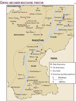
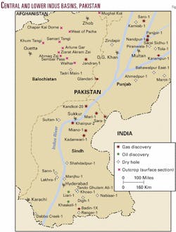
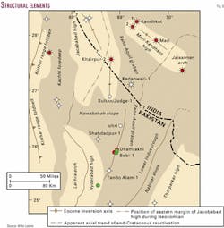
The Union Texas Pakistan Group (UTP) began exploration in Pakistan in 1977 on the nearly roadless area of the Badin Bock in the Lower Indus basin.1 The first oil discovery in the Lower Indus basin at Khaskeli in 1981 opened up the fascinating new play of Lower Cretaceous for petroleum exploration in Pakistan (Fig. 1).
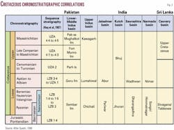
The formations of Cretaceous age recognized in the Indus basin of Pakistan, the Kutch, Saurashtra, and Narmada basins of India, and the Cauvery basin of Sri Lanka have been correlated (Fig. 2).2
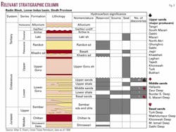
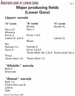
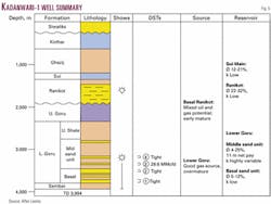
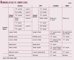
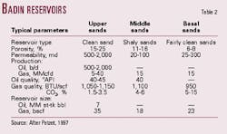
Nomenclature adopted by different oil companies with respect to their concession areas in Pakistan is shown in Table l. Figs. 3, 4, and 5 demonstrate the generalized stratigraphy and major Lower Goru producing fields, respectively, of the former UTP, Oil & Gas Development Co. Ltd., and LASMO PLC. Table 2 summarizes the typical parameters of Badin reservoirs.
The hydrocarbons sourced by Cretaceous Sembar-Lower Goru discovered to date do not compare with the richness of the source, indicating that a great amount still remains untapped.
Fields producing from Upper sand reservoirs far exceed those from Middle-Basal sands. It is recommended to mount an aggressive exploration-drilling effort, particularly for Middle-Basal-Sembar sand prospects. In or near the existing Upper sand fields, little extra logis tical effort will be required to bring the deeper targets on production.
The latter are also the Lower Cretaceous reservoirs sought north of the Badin Block, where the Upper sands have shaled out.
Lower Goru-Sembar geology
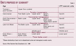
According to Gearhart's study,3 depositional environment is largely controlled by interaction of major interregional eustatic transgressive- regressive cycles with structural evolution of the Indus basin (Fig. 6).
Three major second order cycles (10-80 my) separated by breaks are documented worldwide in the Cretaceous. Lower Goru encompasses the Mid- Cretaceous cycle (Late Aptian-Turonian). Four third order cycles (4 to 10 my) are documented in Lower Goru (Table 3):
- Post Badin cycle: Shale 1, Sand 1.
- Badin cycle: Badin shale, Sand 2.
- Pre-Badin cycle: Middle sand, Sand 4, Ratty sand, Sand 3.
- Early Albian-Aptian cycle: Lower sand.
These cycles are separated by three interregional major transgressive events. Turonian transgression terminated Sand 1's clastic phase with final cessation of deltaic deposition, flooding of the Thar slope, and deposition of Upper Goru sediments. The Cenomanian event terminated Sand 2's clastic phase, with association of emergence and truncation, e.g., the Turk 1 and Mazari 4 wells.
Deposition of Shale 1 and Sand 1 followed. The Vraconian event terminated the clastic deposition of Sand 3, resulting in deposition of the marine shelf deposits of the Badin shale. A fourth regressive event, Late Aptian-Late Albian, defining the base of the pre-Badin cycle, led to the development of delta-related Sand 4 and Sand 3 reservoirs.
Sand 4 (Sand D): Fluvial dominated delta system in Turk field, mixed fluvial-wave domination in Bukhari field.
Ratty sand unit (between Sand 4 and Sand 3): Nearshore-marginal marine-coastal bay deposits under strong proximal deltaic influence.
Sand 3 (Sand C): Mixed fluvial-wave dominated delta system with a restricted embayment between major advancing deltaic lobes in Laghari field.
Badin shale: Shallow marine-marginal marine shelf with moderate deltaic influence.
Sand 2 (Sand B): Wave dominated delta system with prograding and stacked barred, beach shoreface sequences parallel to coastline.
Shale 1: Shallow marine storm-dominated delta system with low deltaic influence.
Sand 1: (Sand A): Storm-wave dominated inner marine shelf, sub-littoral bars and sheet sands, with subparallel orientation to denuded coastline under delta retreat.
The IEDS study4 identified eight lithofacies in cored intervals of Middle and Basal Sands of the Lower Goru formation. They are:
- Bioclastic sandstone.
- Cross-laminated sandstone.
- Horizontal and low angle laminated sandstone.
- Bioturbated sandstone with ophiomorpha.
- Bioturbated argillaceous sandstone with planolites.
- Thinly interbedded claystone and sandstone.
- Claystone.
- Siderite pebble conglomerate.
Deposition occurred in a shoreline setting with actual environments ranging from marine shelf to fluvial channels. Glauconite is present with orthoclase most common in subarkose Middle Sand and decreases downwards. Basal Sand is predominantly quartzarenite.With respect to diagenesis, pre-Late Cretaceous-Early Tertiary trapping of hydrocarbons could have resulted in local preservation of reservoir quality.
Sequence stratigraphy can provide bases of correlation, as the well-preserved sequence boundaries separated by flooding surfaces (condensed sections) have clear potential to be mapped and picked up on seismic sections. Sequence 4 is Lower Basal sand, which can be subdivided into five sub sequences on the basis of wireline logs. The following sequence boundaries are recognized:
- Top sequence 7: Intra-Late Albian.
- Top sequence 6: Intra Late Aptian.
- Top sequence 5: Intra Aptian.
- Top sequence 4: Top Barremian.
- Top sequence 3: Intra Barremian.
Lithostratigraphically, sequence 7 is Middle sands, sequence 6 is Middle sands and Lower shale, sequence 5 is Upper Basal sands and Talhar shale, sequence 4 is Lower Basal sands and Upper Sembar formation. Sands in sequence 4 are discontinuous laterally and vertically.
In sequences 5, 6, and 7, the gamma ray log shows progradation of sand over shelf, and subsequent retrogradational event associated with flooding, with sands forming a semicontinuous blanket. Maximum progradation is noted with deposition of sub sequence 4E. Glauconite is highest at overall marine transgression in subsequences 4F, 7B, and 7C, with low sedimentation rates, best developed in northern wells. Main control on reservoir quality is depth of burial.
Another study5 carried out in 1992 assumes distal Lower Sembar to have been deposited in a faulted Middle Jurassic-Chiltan seabed. The Sembar formation has been divided into five units. The early part, units 2 and 3 are a tidally dominated shelf environment, while the upper portions comprised of units 4 and 5 are wave dominated deposits.
Significant variations in thickness are due to continuous or intermittent movement along an active major NW-SE trending growth fault, and a "horst" block at right angle to this fault. The northeast side acted as a stable block and the southeast corner as a major depocenter with a probable pull-apart basin at end of Sembar deposition. Top Sembar is assigned Early(?) Barremian to Late Hauterivian, while base Sembar is Late Jurassic [Kimmeridgian] in unit 1, whereas unit 2 overlies Middle Jurassic-Chiltan limestone.
Reservoir analyses
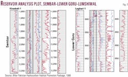
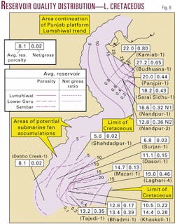
Fig. 7 is the reservoir analysis plot of Sembar formation of Khaskeli Well 1 and of Lower Goru formation from Laghari Well 1.6 Fig. 8 is a map of reservoir quality distribution of Lower Cretaceous-Sembar-Lower Goru-Lumshiwal over the Lower and Middle Indus basin.
The reservoir-gross ratio decreases in Mazari Well 1 to 0.2 and declines even further to the west and north so that in Surjan Well 1, Dabbo Creek Well 1, and Shahdadpur Well 1 shale predominates and reservoir-gross ratios are as low as .04.
Reservoir quality in the eastern and central zone is very good to excellent with high net-reservoir ratios (0.63-0.73). The quality is further demonstrated by high average net and reservoir porosity values. The figures in Laghari Well 4 are 23.2% and 19.0%, respectively, and many of the stacked shoreface sand sequences in the upper section have porosity values in excess of 30%.
Source richness
The Sembar and Lower Goru formations contain prodigious oil and gas prone source rock sequences that developed under the control of wave-tidal regimes-net pay greater than 300 m in or near storm wave base in prodelta and delta front regimes.7
The Upper Sembar sequence, rich in amorphous oil prone kerogen, is richer than many ancient analogs due to longitudinal deposition of ocean geometry rather than the usual latitudinal orientation against well oxygenated Tethyan margins. Realistic Sembar total oil yields are 65-155 million bbl/sq km, which at optimum maturity can source giant fields.
The Basal sand unit of Lower Goru embodies prograding delta sequences that contain sporadic and ephemeral source rock units with humic kerogens. The Talhar shale sequence can generate up to 21 million bbl/sq km. Its thickness varies from 24 m in the southeast to 76 m in southwest of the Badin Block, where it is mature.
References
- Petzet, G.A., "Union Texas hopes to reproduce its Pakistan Badin experience," OGJ, Nov. 3, 1997, p. 86.
- Quadri, V.N., and Quadri, G.J., "Cretaceous of Pakistan, India should hold more promise," OGJ, July 13, l998, p. 85.
- Gearhart Geo Consultants Ltd., "A Review of the Geology of the Lower Goru Reservoir of the Badin," May 1998, OGDCL archives.
- Integrated Exploration and Development Services Ltd., "Middle and Basal Sands of Lower Goru formation," June 1996, OGDCL archives.
- White R.N., "Depositional History and Prospectivity of Sembar Formation," November 1992, OGDCL archives.
- "Pakistan Hydrocarbon Habitat Exploration Promotion Package," January 1988, OGDCL archives.
- Quadri, V.N., and Quadri, G.J., "Anatomy of success in oil and gas exploration in Pakistan, 1915-94," OGJ, May l3, 1996, p. 92.
The authors
Mrs. V.N. Quadri served Oil & Gas Development Corp. from its inception, retiring as acting general manager of exploration after nearly 30 years' service. She carried out several technical studies in collaboration with Russian, Norwegian, Canadian, and US geoscientists and visited China, Norway, Canada, the UK, and the US as Pakistani delegate to Unido, Norad, and Cida petroleum workshops. She has an MS degree in geophysical prospecting from the University of Michigan as a Fulbright-Smith Mundt scholar. [email protected]
S.M.G. Jeelani Quadri has been regional manager of the public sector of OGDC. He was also exploration advisor to Marathon Pakistan Petroleum and Pakistan Shell Oil Co. After retirement from active exploration, he served in the oilfield equipment and services industry for about 10 years. He has a BSc degree in geological and physical sciences from Queen's University and an MSc degree in geological sciences from the University of Toronto.
