Be careful with GPS
Global positioning system (GPS) receivers have silently invaded our industry. For as little as $150, geologists, engineers, and well supervisors can now accurately map surface features, survey pipe- line corridors, spot drilling rigs, and track the passage of crude around the world.
But to better appreciate its capabilities and avoid costly mistakes that may result in incorrect maps and misplaced assets, we need to understand the system's limitations, the ways in which GPS coordinates, and how elevation readings may be confused with traditional mapping systems.
Satellite navigation
GPS, otherwise known as NAVSTAR (Navigation System with Time and Ranging), is a satellite-based, radio-navigation system composed of three fundamental entities: the user, the spacecraft, and ground control.1 Developed by the US Department of Defense in the 1970s, the NAVSTAR constellation now consists of 27 spacecraft (3 spares) that orbit the Earth at a height of 12,600 miles.
NAVSTAR satellites cross the Earth's latitude at 55 degrees in six nearly circular planes, completing a single rotation every 12 hr.2 This configuration allows GPS receivers to lock onto four spacecraft at a time, making it possible to compute latitude, longitude, altitude, and velocity.
Individual satellite emissions contain three pieces of information: pseudo-random codes, ephemeris data, and almanac data. The pseudo-random code ascertains the identity of each individual satellite, the ephemeris states the exact time by reading an atomic clock, and the almanac forecasts the orbital path based on ranging measurements taken from ground control stations.
Once this information is relayed to the user, the ground receiver, which utilizes a synchronized quartz clock, measures the duration of the transmission and then calculates distance. Because the receiver calculates four or more signals simultaneously, a 3D location can be computed through triangulation.
It should be noted that GPS receivers are all-weather devices that can take readings even under cloud cover and through glass windows. The user, however, cannot obtain coordinates in buildings, tunnels, or other barriers that obstruct satellite radio transmissions.
Degradation
Petroleum users must watch out for several problems that can affect coordinate accuracy. Radio transmission through the Earth's atmosphere, for example, can be delayed by ionic interference and water vapor. In turn, a simple 2 sec delay in signal reception can record a user's position 17,000 miles away from the true location.
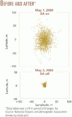
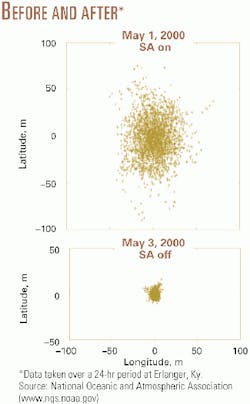
Another problem includes intentional signal degradation by the US government-otherwise known as selective availability (SA). Although the Clinton administration removed SA last May (see figure), the military retains the ability to turn it back on . Prior to this time, geographic coordinate accuracy was on the order of 100 m with a basic handheld device. Today, 15 m is considered the norm. By networking additional GPS units together to form differential GPS, however, readings can be resolved to less than a meter.
Errors in mapping
A lack of basic geodetic knowledge can generate an entirely new set of problems. "If a geologist maps a prospect in a UTM grid plane, but fails to convert these coordinate to WGS84 (the geodetic system used by GPS), a wellsite supervisor may unknowingly misplace a well location," says Martin Rayson, a geodesist with Quality Engineering and Survey Technology Ltd., Houston. "This can lead to a dry hole or an angry landowner."
The problem does not end here. "Elevation readings provided by most inexpensive handheld receivers are not what you think they are," he added. For example, "If the well supervisor uses the GPS to measure a rig's KB, he must be aware that the receiver locates height based upon the WGS84 ellipsoid, a computational surface that best fits the Earth's surface, and not mean sea level." In this case, a correction factor that considers the altitude differences between the geoid and ellipsoid must be used to determine the orthometric height above mean sea level.3 "With a little knowledge however," Rayson added, "these problems can be overcome and GPS can then be used to its full potential."
References
- Parkinson, B.W., Global Positioning System: Theory and Applications (Vol. 1), American Institute of Aeronautics and Astronautics, 1996, p. 11.
- Kennedy, M., The Global Positioning System and GPS, Ann Arbor, 1996, p. 11.
- Smith, J.R., Introduction to Geodesy, Wiley, 1997, p. 75.

