Barnett-sourced Forestburg provides further opportunity in Fort Worth basin
James Henry
Old Aulacogen LP
Frisco, Tex.
Geochemical analysis suggests that the Barnett shale is the source rock for the large majority of producible hydrocarbons in the Fort Worth basin, but there is the possibility that other strata may have also contributed.1 There are few better source rocks in North America than the kerogen-rich, petroliferous Barnett shale. While the economic climate is discouraging for many exploration projects, leases and drilling costs are more affordable now than in the last decade. Fractured carbonates are fair game for development wherever they are found associated with source rocks.
The Forestburg limestone in the Fort Worth basin of North Central Texas, contains shale beds, especially in the lower part of the formation, that are bituminous and likely served as source rocks. Throughout the broad areas where the Forestburg is preserved, it is not possible for the Barnett-sourced hydrocarbons to have migrated into the shallower Strawn, Atokan, and Marble Falls reservoirs without first passing upwards through the entirety of the immediately overlying Forestburg formation, almost certainly via vertical fractures.
During that process, whatever primary or secondary porosity existed in the Forestburg was charged with those same hydrocarbons, and the vast majority of that oil and gas is still in those rocks waiting for an economic climate that will justify its extraction.
The Forestburg play will likely generate more drilling activity in the Fort Worth basin than the Marble Falls with the potential to rival the Barnett shale.
History
The Forestburg limestone is a sequence of hard, brittle carbonates interbedded with smaller intervals of black petroliferous shales. The formation is Chestarian (the latest Mississippian) in age. Where present, it conformably overlies its immediate predecessor, the Barnett shale. Its upper surface is truncated by the midcontinent-wide North American unconformity that separates the Mississippian and Pennsylvanian systems. In most areas of North Texas, the earliest overlying Pennsylvanian (Atokan) rocks belong to the Marble Falls formation (OGJ Online, Nov. 5, 2012).
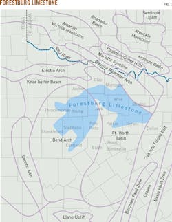
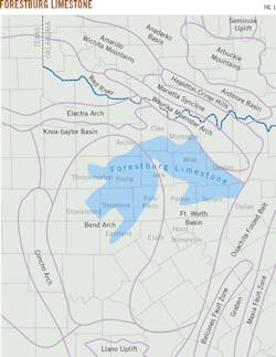
The Forestburg covers all or part of fifteen counties in North Texas (Fig. 1). The asymmetrical highlighted area shows its subsurface location. It is generally thickest in its northern and eastern portions and thins southward and westward due to pre-Atokan erosion. The formation is not present on the outcrop.
Before 1982, the Forestburg limestone was commonly confused with the lower Marble Falls formation and mistaken for the Comyn or Duffer formation, two names synonymous with the Marble Falls. The Forestburg limestone's name came into popular use as the Barnett shale began development in southeastern Montague County.2
Despite being overshadowed by the Barnett shale in the early 1980s, the Forestburg formation had already been producing oil and gas for nearly 40 years. The field was discovered by the Sinclair Prairie No. 1 Jones well in Forestburg, Tex., in 1941 just weeks after the US entered World War II in 1941.
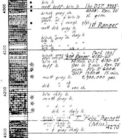
At the time, the producing formation had no proper name, but it ultimately produced 341,000 bbl of oil and an unmeasured volume of gas from eight wells with no stimulation comparable to modern hydraulic fracturing techniques. Later that decade, 90 miles away in Stephens County, the Texas Co. No. 1 A.M. Moon well paused to drillstem test a gas show in an anonymous sub-Marble Falls limestone several miles northeast of Breckenridge, Tex. The well flowed gas to surface in 2 min. at the rate of 2.9 MMcfd (Fig. 2).
Completing the Moon well in 1948 through perforations in that same zone yielded 11 MMcfd of gas. Ultimate production is unknown, and there is no evidence the well was connected to a pipeline.
Several dozen vertical wells completed since in southeastern Montague County in the same stratigraphic horizon in Bingham Creek, South Dye Mound, and Hundley Fields did not create a Forestburg boom.
Forestburg lithology
An operator plugged back to the Forestburg in 2011 after drilling a disappointing Barnett well in southwestern Jack County. The Forestburg was hydraulically fractured with 140,000 lbs of sand, and the operator reported testing 1.1 MMcfd of gas with little to no oil or water before the sand flowed back into the casing requiring recompletion in a shallower zone.
The Forestburg represents the latter half of a two-part sedimentary event that covered the Fort Worth basin, the Bend Arch, and part of the eastern shelf of the Midland basin in latest Mississippian time. Throughout the basin the Barnett shale is easily identified on conventional porosity logs. It is notably more radioactive than any other shale in the basin, and its mean bulk density of 2.5 g/cc makes it considerably lighter than any of the other Paleozoic shales. But mud loggers have trouble calling the top of the Barnett while drilling because the immediately overlying limey shales and shaley limestones of the Forestburg are lithologically similar in color and texture. The typically greasy Barnett facies and the rocks that conformably overlie it were all part of a single depositional event that occurred during the Chesterian stage, producing the present-day similarity. The rich petroliferous, bituminous depositional environment that produced the Barnett shale was still largely present in the Fort Worth basin while the Forestburg sediments were accumulating. Later, after lithification, the tectonic forces that uplifted the Muenster Arch and fractured the Barnett shale also fractured the Forestburg.
The Forestburg formation consists of massive limestones that are extremely dense (2.7 g/cc) on bulk density logs and cleaner on gamma ray logs than any other rock unit in the Fort Worth basin. A 2010 study explained the high bulk-density readings as micritic limestones with interbeds of dolomitic claystone that "occur every 2.4-14 in. and are 0.6-3.0 in. thick."3 These massive rock units are occasionally separated by less massive shale beds that do not closely resemble the Atoka shales slightly higher in the section. The Forestburg carbonates are gray to dark gray and non-fissile; the shales are invariably black. The formation is extensively fractured vertically, horizontally, and at all angles in between. Some of the fractures have been completely healed with quartz or calcite, some partially so, and some not at all. The oil gravity varies between 35° and 47° API.
Deposition
Unlike other post-Ordovician formations in the Fort Worth basin, deposition of the Forestburg was cyclical. Depending upon the degree to which pre-Atokan erosion has breached the formation, the number of preserved shale-limestone cycles in any given borehole may vary from a fraction of the first cycle to almost all of the third or fourth. How many more cycles there may have originally been is unknown because a full original section of the Forestburg doesn't exist (Fig. 3). The formation thickens gradually from west to east across most of the basin. The dip is about 1° (100 ft/mile) to the east, and there is little or no faulting involved. Keeping a horizontal drill bit within the boundaries of such a formation is easy.
Fig. 3 shows the induction log of the Taubert & Steed No. 9 Teague well, Sec. 2772 (A-714), Texas Emigration and Land Survey, northwestern Jack County, Tex. Three calcareous depositional cycles are preserved in the Forestburg formation at this location. The third cycle has been partially truncated by pre-Atokan erosion and is overlain by the Pennsylvanian Marble Falls formation.
The factor causing the lightweight, radioactive deposition in the Barnett ceased or migrated laterally rather quickly at some point in the 15-million year Chestarian stage. The other lithologic constituents of the Barnett continued to be deposited without interruption in a relatively calm, shallow epicontinental sea. In parts of the Fort Worth basin, the depositional environment of the classic Barnett lithology returned for a brief encore and left a couple dozen of typically radioactive shale about 100 ft above the main mass of the Barnett beds. Industry geologists commonly refer to this as the "false" or "upper" Barnett.
Nearly 450 ft of post-Barnett, Forestburg rocks can be found at depth in the northwestern corner of the Fort Worth basin near the Jack-Young County line between Jermyn and Loving, Tex. On the northeastern edge of Jack County, 30 miles away, that same formation approaches 500-ft thickness. Between those two locations lies an area where the Forestburg has been thinned by pre-Atokan erosion, and in some places is entirely gone, and the basal Pennsylvanian unconformity cuts directly into the Barnett shale.
The Marble Falls and the Forestburg together occupy a vertical interval of about 500 ft through most of Jack County. The two formations thicken and thin inversely, suggesting the Marble Falls was deposited on a gentle, near-shore Forestburg terrain and preferentially filled in the paleotopographic lows. A careful and detailed isopach of the Forestburg in Jack County (too large to be depicted here) shows a dendritic pattern with the unmistakable symmetry of a subaerial drainage system. Now buried beneath more than 5,000 ft of Pennsylvanian and Permian sediments, the main channel was oriented generally NNW-SSE and flowed southerly through the county as it passed just 1-2 miles east of present Jacksboro, Tex.
The here-named Jacksboro River was a very real and well developed fluvial pattern meandering across the low-standing paleoplain of mid-North America during the widespread Mississippian-Pennsylvanian erosional hiatus. We can follow the deeply incised main channel at least as far down the paleoslope as the southeast corner of Jack County where it debouched into Palo Pinto and Parker Counties. No other area of preserved Forestburg sediments exhibits the magnitude of erosional paleotopography seen in Jack County.
The greatest thickness of Forestburg yet-penetrated by a vertical borehole is about 550 ft in the historic 1959 Magnolia No. 1 Trigg in the northwestern corner of Dallas County. About 2 miles to the east, the Forestburg is laterally obliterated by the early Pennsylvanian Ouachita overthrust belt. To the north, all Mississippian strata are absent due to uplift and erosion on the southern flank of the Electra-Matador-Red River Arch, most deeply on the Nocona anticline in north central Montague County.
Like the Fort Worth basin itself, Mississippian rocks abruptly end in east-northeast Montague County by the lofty Muenster Arch. In the Marietta basin on the far side of the arch, Mississippian formations return, but do not include any Barnett or Forestburg remnants. Nor does either rock unit appear in the Ardmore or Anadarko basins of southern Oklahoma.
References
1. Hill, R.J., Jarvie, D.M., Zumberge, J., Henry, M., and Pollastro, R.M., "Oil and Gas Geochemistry and Petroleum Systems of the Fort Worth Basin," AAPG Bulletin, Vol. 91, No. 4, April 2007, pp. 445-473.
2. Henry, J.D., "Stratigraphy of the Barnett Shale (Mississippian) and Associated Reefs in the Northern Fort Worth Basin," Petroleum Geology of the Fort Worth Basin and Bend Arch Area: Dallas Geological Society, 1982, pp. 157-178.
3. Farrar, K.M., "Stratigraphy of the Marble Falls Interval (Pennsylvanian), Jack and Wise Counties, Texas," Masters thesis, Texas Christian University, May 2010, pp. 109.
The author
James Henry ([email protected]) is an independent consulting geologist with Old Aulacogen LP, Frisco, Tex. In past positions he has worked as a geologist for Getty Oil Co. and Mitchell Energy. He has also worked at various positions with Core Oil & Gas and Beard Oil Co. He earned his BS in geology at University of Texas, Austin.


