Central Illinois shows Siluro-Devonian oil potential
Yaghoob Lasemi
Illinois State Geological Survey
Champaign, Ill.
The Siluro-Devonian is one of the hottest oil and gas plays in the Illinois basin.
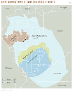
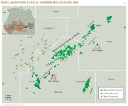
The play is centered in the basinward margin of the Mount Auburn trend along the southern flank of the Sangamon arch in central Illinois (Figs. 1 and 2).1 It consists of multiple geologically related prospects that comprise laterally discontinuous reservoirs in the Silurian Racine and Devonian Lingle formations at an average depth of 2,040 ft.
The Sangamon arch is defined by the zero thickness contour line of the Middle Devonian deposits. During Silurian time, a shelf margin was located about 70 miles southeast of the Mount Auburn trend facing the deep Vincennes (Fairfield) basin, the northern margin of which was the site of large pinnacle reef development.
Production is limited to a band about 7 miles wide and more than 45 miles long paralleling the strike along the southeastern margin of the Sangamon arch (Fig. 2), where all geologic conditions for reservoir development, petroleum generation, and accumulation are favorable.
Shallow depth and occurrence near the organic-rich Upper Ordovician Maquoketa and Upper Devonian New Albany shale units make the Siluro-Devonian productive horizons excellent exploration targets.
The Mount Auburn trend area is in Macon and Christian counties and has been a center of activity since 2010 with many companies obtaining acreage positions for exploration.
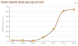
From the early 1980s to 2010, the search for oil in the Mount Auburn trend area was sporadic: just before 2010, only one or two permits per year for oil and gas exploration were issued (Fig. 3).1 Since 2010, the number of permits has risen sharply to sharply to 60 and 63 in 2012 and 2013, respectively.
Renewed interest in exploration was spurred by the Illinois State Geological Survey work on the Mount Auburn trend in which a depositional and dolomitization model was presented providing an important predictive tool for exploration.3 4 5 The model has resulted in a number of prolific wells being completed in 2011 and 2012.1
In Macon County, four wells on Production Energy LLC's Bowman and Butterfield leases produced more than 295,000 bbl of oil from April 2011 to December 2012. In Christian County, two wells on the Belken Oil LLC Sheldon lease produced more than 160,000 bbl of oil in 2012.
This article concentrates on the southeastern margin of the Sangamon arch in Macon and Christian counties, where both Silurian and Devonian rocks have great reservoir potential.
Geological background
The Sangamon arch is a broad southwest-trending structure on a gently sloping ramp area in the northwestern portion of the Illinois basin in west-central Illinois (Fig. 1).
It was formed as a result of upwarping during Silurian through Middle Devonian times.6 Upwarping of the arch resulted in erosion-nondeposition of the Upper Silurian through Middle Devonian rocks on the Sangamon arch.
The Silurian succession of the Sangamon arch constitutes the upper part of the Tippecanoe sequence of Sloss and consists chiefly of carbonate rocks.7 The upper part of the Silurian carbonates is classified as the Middle Silurian Racine formation (Fig. 4), which consists mainly of interbedded limestone and dolomite.8
An intra-Racine unconformity divides the Racine formation into two depositional sequences consisting of several oil-producing dolomite horizons (Fig. 4).9 The Middle Devonian Lingle formation is a part of the lower Kaskaskia sequence and is present in the basinward margin of the Mount Auburn trend (Fig. 5).7 10 11 It consists mainly of fossiliferous limestone containing thin beds of dolomite, sandy dolomite, dolomitic sandstone, or conglomerate.
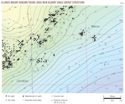
The Mount Auburn Trend encompasses a number of oil fields in Macon and Christian counties (Fig. 2). The structure contour map shows that production lies on the regional dip that gently slopes to the southeast (Fig. 6). A combination of depositional and diagenetic stratigraphic traps generally control petroleum entrapment in the Mount Auburn trend.3 4 5 12
The reservoirs normally are sealed by lime mudstones to packstones that were deposited in quiet-water environments following the flooding stages of high frequency sea level cycles. Erosion at the sequence boundaries locally has resulted in partial or total removal of the interval that could otherwise include porous reservoir facies.5
Production history, discoveries
Following the initial commercial oil well discovery in 1921 at Decatur field in Macon County, exploration and drilling commenced in the southern margin of the Sangamon arch.
By the mid-1980s, several oil fields were discovered. Nearly 33 million bbl of oil have been produced from these fields chiefly from the Silurian nonreef dolomite reservoirs in Macon, Christian, and Sangamon counties.
Along the southeastern flank of the Sangamon arch, oil production is chiefly from dolomite reservoirs in the Middle Silurian Racine formation and is centered in Macon, Christian, and Sangamon counties.5 The long-productive Mount Auburn trend extends for nearly 45 miles from central Macon County across northern Christian County (Fig. 2) and encompasses several oil fields that have produced more than 18 million bbl of oil.
Until very recently, except for the drilling activity during the early 2000s in the Sharpsburg NW area, Christian County (Fig. 2), the search for oil in the Mount Auburn trend was sporadic. The trend is currently experiencing a third phase of development following drilling booms in the late 1940s to mid-1950s and the late 1960s to early 1980s.1
In April 2011, Production Energy completed No. 1 Bowman, a Silurian test well in 5-15n-2e, Macon County. No initial production was reported, but according to the Illinois Pipeline Production Report, by December 2012 cumulative recovery exceeded 114,000 bbl of oil, indicating a prolific producer. The producing horizon is a fossiliferous limestone, the top of which was reached at 2,196 ft.
From April 2011 through December 2012, four wells on Production Energy's Bowman and Butterfield leases produced more than 290,000 bbl of oil. These wells are 1.2 miles southeast of the Mount Auburn trend Harristown South field (Fig. 2). Discovered in 1975, Harristown South field has accumulated about 150,000 bbl of oil from nine wells.
In January 2012, Belken Oil LLC completed No. 1 Sheldon, a Silurian test well, in 28-14n-2w, Christian County, with initial production of 1,440 b/d of oil flowing from a dolomitic sandstone and dolomite reservoir encountered at 2,009 ft. By December 2012, it produced more than 82,000 bbl of oil.
Sheldon No. 2 was completed in March 2012 and together with Sheldon 1 accumulated more than 160,000 bbl of oil.
The wells are about a mile southeast of Sharpsburg NW field (Fig. 2) that produces from Silurian and Devonian reservoirs. They lie between the prolific Production Energy Macon County wells about 20 miles to the northeast and Kincaid Consolidated field that is 6 miles southeast. Kincaid field (Fig. 2) has produced more than 6.7 million bbl of oil mainly from Devonian reservoirs since 1955.
The recent discoveries in Macon and Christian counties are along the basinward margin of the Mount Auburn trend's fields (Fig. 2). Production is mainly from the "Hibbard" pay zone, which could be very prolific as indicated previously.
Primary production in several wells has been much higher than the average producing well. In this part of the Illinois basin, the average primary oil production during the entire life of a well is less than 25,000 bbl.
Reservoir rocks
In the Mount Auburn trend of the Sangamon arch, production is mainly from porosity zones developed in the Silurian Racine formation and is limited to a band about 5 miles wide along the southeastern margin of the Sangamon arch.5 12
Basinward, prolific reservoirs occur in the Devonian Lingle formation near the Middle-Upper Devonian unconformable boundary in the strata that wedge out against the arch in a band that is about 4 miles wide in the southern margin of the Mount Auburn trend. The reservoirs generally are porous, vugular fine to coarsely crystalline dolomite, and their porosity may exceed 20% in some horizons. They are compartmentalized and occur as lenticular bodies in the upper part of small-scale shallowing-upward cycles (Figs. 4 and 5).5 12
The reservoirs in the Racine formation consist of dolomitized nonreef and patch reef facies (Fig. 4) in the upper and lower sequences of the Racine formation, respectively.3 4 5 The Lingle reservoir, the "Hibbard sand" pay zone, is a porous dolomite, sandy dolomite, dolomitic quartz sandstone, or fossiliferous limestone.9 It is laterally discontinuous (Fig. 7) and may occur as two separate horizons in the upper part of shallowing-upward cycles (Fig. 5).
Basinward, in the southeastern margin of the Mount Auburn trend, the reservoirs in the upper sequence of the Racine formation lose their effective porosity, and erosion at the Siluro-Devonian boundary may have removed the productive part of the Racine lower sequence.
Within the trend, however, prolific reef and reef related reservoirs could be discovered in the lower sequence. In 1962, Atkins & Hale completed Dipper No.1 in 28-16n-1e, Macon County, with an initial production of 3,120 b/d of oil, the highest reported in the Sangamon arch area.
Dipper No. 1 is in Blackland North field, just northwest of Harristown South field (Fig. 2). The main oil saturated zone is in a reef and reef rudstone facies at depths of 2,003-2,037 ft within the upper part of the lower Racine sequence.3 5 The Dipper and an offset well to the southwest have accumulated more than 216,000 bbl of oil. However, in the Mount Auburn trend, most wells drilled thus far have not been deep enough to test the lower Racine sequence.
Models for reservoir development
The area encompassing the Sangamon arch and its basinward flank, during Silurian through Devonian time, was a gently sloping ramp with a shelf margin located about 70 miles to the southeast, and it was facing a deep basin called the Vincennes basin (Fig. 1).13 14 During the Silurian, the shelf margin was favorable for growth of large pinnacle reefs on the northern and eastern edges of the Vincennes basin.14 15
In the Mount Auburn trend, depositional facies and dolomitization were important factors that controlled porosity development in the Siluro-Devonian deposits.1 4 5 The Siluro-Devonian rocks were deposited in shallow marine environments that covered central Illinois during sea level highstands. The reservoir rocks are mainly dolomitized nonreef or small patch reef facies containing ghosts of fossils of the original precursor limestone.3 4
The skeletal remains of marine organisms along with sands brought to sea from land were transported by currents and deposited as lenticular sand bodies in nearshore areas, making reservoirs for oil; patch reef reservoirs formed where colonies of organisms, like corals or bryozoans, lived seaward of ramp margin sand bodies.1
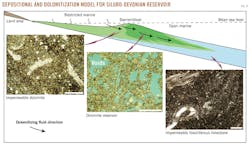
The reservoir bodies were formed along a northeast-southwest trending ramp margin that was roughly parallel to the Sangamon arch trend and graded basinward into muddy facies below wave base.5 In the areas close to restricted settings, dolomite reservoirs were formed due to dolomitization of previously deposited sediments by percolation of saltier magnesium-rich seawater through sediment (Fig. 8).1 4 5 12 Reservoirs were capped by laterally continuous impermeable limestone beds during transgression, and they display cyclic reservoir-nonreservoir packages.
Exploration potential
The proposed model is an effective tool for exploration; it is a predictive tool for defining the approximate location of potential Siluro-Devonian reservoirs in the unexplored areas of the Sangamon arch.
Several stacked lenticular reservoirs are present in the Siluro-Devonian succession of the southeastern margin of the Sangamon arch. The Devonian reservoirs are present where the Lingle pinches out against the arch in a belt paralleling the southeastern margin of the Mount Auburn trend oil fields. They occur in the same stratigraphic position, and their characteristics are similar to those in prolific Kincaid and Assumption fields, Christian County.
The potential for new Silurian discoveries in the Mount Auburn trend appears to be excellent in the unexplored areas between the existing fields and in the deeper horizons considering that there are many oil fields with few or no tests in the deeper zones.
Porous reservoirs were developed by partial cementation or dolomitization of the previously deposited sediments. Dolomitization was caused by reflux of slightly evaporated seawater through the sediment shortly after deposition. Therefore, depositional setting, percolating seawater, and sea level fluctuations were the primary controls for their development.4 5
Acknowledgments
Critical review of the first draft of the manuscript by R.C. Berg and S.D. Elrick is greatly appreciated. Z. Askari assisted in the digitization of geophysical log raster images.
References
1. Lasemi, Y., "The Siluro-Devonian play along the southern flank of the Sangamon arch, central Illinois: recent discoveries, reservoir facies, and future potential," Abs. 1556666, AAPG Annual Convention & Exhibition, May 19-22, 2013, Pittsburgh.
2. Buschbach, T.C., and Kolata, D.R., "Regional setting of Illinois basin," in Leighton, M.W., Kolata, D.R., Olts, D.F., and Eidel, J.J., eds., "Interior cratonic basins," AAPG Memoir 51, 1991, pp. 29-55.
3. Lasemi, Y., "Oil potential seen in Silurian reef-related reservoirs in Illinois Sangamon arch," OGJ, Aug. 3, 2009, p. 36.
4. Lasemi, Y., "Sea level and diagenetic controls on dolomite reservoir compartmentalization: Evidence from the Niagaran Racine formation of the Sangamon arch, west-central Illinois," AAPG Eastern Section meeting abstracts, Sep. 25-29 2010, p. 44.
5. Lasemi, Y., Seyler, B., Lasemi, Z., and Askari Khorasgani, Z., "Sedimentology and reservoir characterization of the Silurian deposits in the Mount Auburn trend of the Sangamon arch, west-central Illinois," Illinois State Geological Survey Circular 577, 2010.
6. Whiting, L.L., and Stevenson, D.L., "The Sangamon arch," Illinois State Geological Survey Circular 383, 1965.
7. Sloss, L.L., "Sequences in the cratonic interior of North America," GSA Bull. 74, 1963, pp. 93-114.
8. Willman, H.B., and Atherton, E., "Silurian system," in Willman, H.B., Atherton, E., Buschbach, T.C., Collinson, C., Frye, J.C., Hopkins, M.E., Lineback, J.A., and Simon, J.A., eds., Handbook of Illinois Stratigraphy, Illinois State Geological Survey, 1975, pp. 87-104.
9. Lasemi, Y., "A prominent unconformable boundary within the upper Niagaran Racine formation: record of a major Middle Silurian tectono-eustatic event in the Sangamon arch, west-central Illinois," GSA North-Central meeting abstracts with programs, Vol. 41, No. 4, 2009, p. 26.
10. Whiting, L.L., "Geology and history of oil production in the Decatur-Mount Auburn-Springfield area, Illinois," Illinois State Geological Survey Circular 211, 1956.
11. Collinson, C., and Atherton, E., "Devonian System." In: Willman, H.B., Atherton, E., Buschbach, T.C., Collinson, C., Frye, J.C., Hopkins, M.E., Lineback, J.A., and Simon, J.A., eds., "Handbook of Illinois stratigraphy," 1975, pp. 104-123.
12. Lasemi, Y., "Sequence stratigraphic control on reservoir development: the Middle Silurian Racine formation in the Sangamon arch, west-central Illinois," AAPG annual convention and exhibition abs., 2012, p. 254 (AAPG Search & Discovery Article #50694).
13. Ahr, W.M., "The carbonate ramp: an alternative to the shelf model," GCAGS Transactions, Vol. 23, 1973, pp. 221-225.
14. Droste, J.B., and Shaver, R.H., "Upper Silurian and Lower Devonian stratigraphy of the central Illinois basin," Indiana Geological Survey Special Report 39, 1987.
15. Shaver, R.H., Ault, C.H., Ausich, W.I., Droste, J.B., Horowitz, A.S., James, W.C., Okla, S.M., Rexroad, C.B., Suchomel, D.M., and Welch, J.R., "The search for a Silurian reef model, Great Lakes area," Indiana Geological Survey Special Report 15, 1978.
16. Bristol, H.M., "Silurian Pinnacle reefs and related oil production in southern Illinois," Illinois State Geological Survey, Illinois Petroleum 102, 1974.
The author
Yaghoob Lasemi ([email protected]) is a carbonate sedimentologist/reservoir geologist in the Coal and Petroleum Geology Section, Illinois State Geological Survey, PRI Institute, University of Illinois at Urbana-Champaign. He worked as an exploration geologist in southern Illinois from 1981-87, worked and lectured short courses related to petroleum geology in the NIOC Exploration Office, Tehran in 1988 and 1990-98, respectively, and was a faculty member in the Department of Geology at Khwarizmi (formerly Tarbiat Moallem) University in Tehran from1989-07. He has a PhD from the University of Illinois at Urbana-Champaign, an MS from Michigan State University, and a BS degree from Tehran Teachers College.
