There's an app for that
Tayvis Dunnahoe
Exploration Editor
Geologists work where the rocks are, but advancing technology continually lightens the load for those in the field.
A new app developed by University of Wisconsin, Madison, geoscience Prof. Shanan Peters and former geologist for the Wisconsin Geological and Natural History Survey Patrick McLaughlin is putting a portable, GPS-powered field guide in the palm of users' hands.
"The big idea is, 'Tell us what you saw, and I will tell you what I saw,'" Peters said in a press release. Users of the free geology app, known as Rockd, can upload their field observations and photos, and compare those to what other users know about the location.

According to its makers, Rockd overcomes the limitations on geologic maps-their focus on big structures. "Using a map, it can be hard to tell specifically where to go to see a particular rock unit exposed at the surface," he said.
The app provides a virtual map and a method of simple annotation, and it uses information from extensive databases such as Macrostrat, the Paleobiology Database, which was spearheaded by Peters as an accessible interface to large geologic data sets. Rockd also will expand the sum of geologic knowledge as the crowd-sourced data feeds back into the app's data structure.
New app, not concept
With the iPhone now in its 7th iteration, geology apps have been introduced in recent years, and the functionality of handheld technology has changed the way some geologists gather field data.
In 2015, a group headed by Prof. Christopher Liner at the University of Arkansas, Fayetteville, outlined methods of using an iPhone to conduct geologic field studies. His team located unreported outcrops of the Mississippian Boone limestone formation in northwest Arkansas with a program it coined MArkUP (OGJ Online, Mar. 2, 2015).
The project was carried out using free software at a fraction of the standard cost of a geological field survey.
Modern smart-phone technology and open software have the potential to revolutionize field geology. With more advanced approaches to handheld technology, reconnaissance geology of vast areas may soon come with less time, effort, and cost.
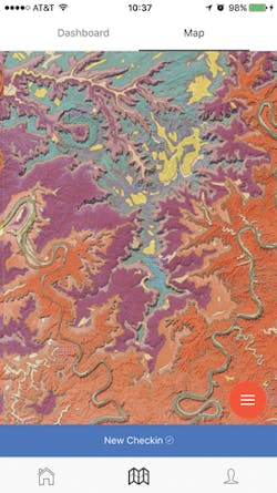
A river-dissected plateau near Moab, Utah, shown in the Rockd app, uses colors to display the age of rocks, and two winding rivers cut deeply into the strata. Photo from Rockd.