Seismic anomalies expand Alaska’s Umiat Anticline potential
Paul McColgan
McColgan Seismic Interpretation Services LLC
Cincinnati
Nilesh Dixit
Arizona State University
Glendale
Jacob T. Murchek
US Geological Survey
Reston, Va.
Development of Umiat oil field on Alaska's North Slope has been hindered by geological and logistical difficulties. Discovered more than 80 years ago, the field experienced minimal drilling, and initial assessments indicated that oil deposits were primarily contained within low-pressure permafrost zones. Recent advancements in seismic technology, particularly amplitude variation with offset (AVO) analysis, however, redefined the potential of the Umiat anticline.
Reconditioned existing 3D seismic data identified significant hydrocarbon related anomalies which suggested deeper, more conventional reservoirs lying beneath the permafrost zone, mitigating previous production issues. This new seismic interpretation expands the field's potential oil in place to more than 2 billion bbl, doubling prior estimates.
A newly-defined, unleased prospect (Tukkuttok) exists under normal pressure conditions and may make commercial production feasible. With potentially high-quality light crude oil and favorable reservoir conditions, Umiat could have broader implications for Arctic oil exploration.
North Slope
Alaska’s North Slope encompasses the Alaska Outer Continental Shelf and the Brooks Range foothills and contains an estimated 60 billion bbl of in-place light and heavy crude oil.1 As many of its northern fields reach maturity, however, focus has shifted toward identifying new reserves and maximizing untapped resources.
Advancements in drilling and completion technologies (e.g., horizontal drilling) combined with a deeper understanding of the region’s complex geology have recently led to major discoveries in the Brookian sequence reservoirs, with some as large as 1-2 billion bbl.2 One potentially promising yet underdeveloped field is Umiat. It presents a potential opportunity for future development with more than 1 billion bbl oil in place within Brookian reservoirs.3
Despite being discovered more than 80 years ago, Umiat has seen minimal drilling activity, with only 13 wells drilled and no significant production due to geological and logistical difficulties.4 Until 2019, its oil accumulations were thought to be confined solely to low-pressure permafrost rocks, classifying it as an unconventional resource. With advanced analysis of seismic attributes and modern drilling techniques, however, Umiat holds potential as a major oil-producing region.
Umiat oil exploration
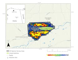
Oil and gas exploration in Alaska’s Arctic region dates to the US Navy’s exploration program between 1944 and 1953. During this period, the Navy conducted drilling operations in Naval Petroleum Reserve No. 4 (now recognized as the National Petroleum Reserve Alaska) to assess its hydrocarbon potential. One of the primary targets of this initiative was the Umiat anticline, a geologic structure in the southeastern corner of the reserve on the north side of the Colville River (Fig. 1). The anticline extends east to west measuring about 3 miles wide and 10 miles long.
During this exploration phase, a total of 11 wells were drilled on the anticline with 572-6,212 ft depths. The most significant oil shows were encountered at 660-760 ft depths within the sands of the lower Grandstand interval of the Cretaceous Nanushuk formation. These oil-bearing sands, however, were within the permafrost zone which extends about 900 ft below the surface, presenting unique drilling and production difficulties.
The results of the Navy’s drilling program at Umiat provided insights into the structure and reservoir characteristics of the field. The first well, Umiat Test Well #1, was drilled to a depth of 6,005 ft and encountered multiple oil shows in the Grandstand interval. However, it failed to produce hydrocarbons during testing and was ultimately plugged and abandoned.
Further analysis revealed that the well had intersected a reverse fault with a vertical displacement of 775 ft and had been drilled 5 miles west of the anticline’s apex, potentially explaining its lack of production.
Subsequent drilling focused on delineating the reservoir. Test Wells #2-#5 were drilled along the crest of the anticline, whereas Test Well #6 and Test Well #7 targeted the southern flank, and Test Well #11 targeted the northern flank.
Test Well #2 encountered oil shows in the Grandstand interval but failed to produce oil and was classified as a dry hole. Test Well #3 achieved a flow rate of 24 bo/d from the Grandstand interval, but freshwater drilling mud infiltrated the reservoir and froze within the formation, raising concerns about flow restrictions.
To address these issues, the mud system was switched to a brine-based solution for Test Wells #4 and #5. Test Well #5 was positioned 200 ft east of the dry hole Test Well #2. The mud adjustment resulted in significantly improved production, with Test Well #4 producing 100 bo/d, and Test Well #5 achieving 400 bo/d, the highest flow rate among all vertical wells drilled on the anticline.
On the southern flank, additional wells were drilled to determine the oil-water contact. Test Well #6 was intended to reach the lower Grandstand interval, but mechanical issues prevented the well from being drilled deep enough to confirm the full extent of the reservoir. Test Well #7, which was positioned even farther down-dip, was the lowest well structurally positioned on the anticline’s south limb. It yielded only minor oil shows in the Nanushuk formation, with no indications of hydrocarbons in either the upper or lower Grandstand interval. Test Well #11, which was drilled on the north flank of the structure, contained water with no significant oil shows.
Despite the logistical and technical difficulties encountered during these early drilling campaigns, several wells demonstrated flow rates between 60 and 220 bo/d, confirming the presence of a working petroleum system within the Umiat anticline. Low reservoir pressure, permafrost conditions, and the absence of infrastructure prevented commercial viability at the time. These early exploration efforts laid the foundation for modern evaluations of Umiat’s potential. Advancements in seismic imaging, drilling technology, and production techniques offered new opportunities to map the field.
In 2007 and 2008 Renaissance Alaska LLC conducted an 82-sq mi proprietary 3D seismic survey from the Umiat anticline with the primary objective of imaging deeper structural features to assess the potential for additional oil prospects.5 The presence of oil in the shallower Grandstand interval provided the rationale behind this exploration and led to the hypothesis that deeper reservoirs could also contain hydrocarbons. To the best available knowledge, however, no significant deep prospects were identified or drilled based on this survey.
Between 2008 and 2012, research efforts at Umiat shifted toward evaluating techniques for producing oil from a permafrost-affected reservoir. The University of Alaska Fairbanks Geophysical Institute, in collaboration with two energy companies and with financial support from the Department of Energy, led studies aimed at overcoming difficulties associated with extracting hydrocarbons from frozen formations. During this time, additional wells were drilled, including a horizontal well on the crest of the anticline, to enhance production. Despite these efforts, the project failed to yield commercially viable results.
Drilling activity at Umiat continued until 2014 but, without significant breakthroughs in production, development efforts stalled.6 The asset remained largely dormant until it was acquired by 88 Energy in 2021. A notable turning point occurred in 2018 when the proprietary rights for the Umiat 3D seismic data expired, making the dataset publicly available through the State of Alaska.
This development opened new opportunities for independent evaluations of the field’s potential, setting the stage for a renewed exploration phase leveraging advanced seismic interpretation techniques.
New Umiat AVO interpretation
The new fully corrected, three-dimensional pre-stack time migrated (PSTM) data gathers identified direct hydrocarbon indicators (DHI) in Umiat. Previous interpretations focused on mapping structural features and stratigraphic trends in the stacked seismic section and paid only minor attention to pre-stack seismic attribute analysis (Fig. 2).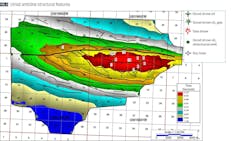
AVO, a pre-stack seismic interpretation method, analyzed the change in the amplitude of the reflected P-wave relative to increasing offset (or angle of incidence) along an interface between two rock types.7 This method often provides insight into the pore fluid content present within a rock formation and may be indicative of hydrocarbons. AVO analysis applied to 3D seismic data acquired from Umiat field identified prospective zones which may have been missed by previous interpretations.
The PSTM gathers, provided by the State of Alaska, generated AVO intercept and gradient volumes to identify anomalous amplitude behavior in the pre-stack domain. Search parameters for AVO volumes were adjusted after manually examining the initial anomalies on the gathers.
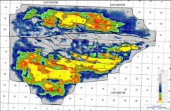
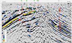
This adjustment led to the creation of the final gradient volume for interpretation, set between 10° and 40° and highlighting areas with the largest gradient values. The volume revealed one significant and widespread event and two lesser events (Fig. 3). The seismic section showed that some of the AVO events stopped for no apparent reason, raising questions concerning their validity (Fig. 4).
To address this issue, it was necessary to enhance the image quality of the seismic data, particularly along the crest where most of the wells are located, before determining if the AVO anomalies could be associated with hydrocarbons.
The poor signal quality along the crest was likely a result of the seismic acquisition parameters, which were optimized for imaging deeper targets rather than the shallow depths of the known reservoir. Gather restacking used a stretch mute until the best image was achieved to resolve this problem.8
The revised stack was then filtered with a 10-hz Ricker wavelet, effectively reducing the high frequency noise that contaminated the image. Further noise reduction and improved signal continuity were achieved through application of a more advanced post-stack noise suppression algorithm configured with mild parameters to avoid smearing through faults. The improved image significantly enhanced the correlation between the seismic data and the synthetic model generated from the Seabee #1 sonic log, identifying formations responsible for the AVO response (Fig. 5).9
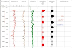
This synthetic tie revealed that the large AVO anomaly corresponded to the lower Grandstand interval, with smaller anomalies identified as the upper Grandstand and Ninuluk intervals within the Nanushuk formation.
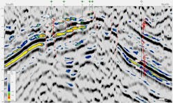
The reconditioned data also revealed previously undetected faults that appear up dip and in front of the abrupt truncations of the AVO anomalies (Fig. 6). These anomalies extend well down dip of the original closure and are associated with the three sand formations known to have produced oil on the crest.
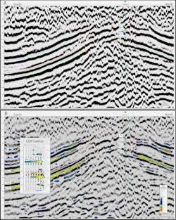
A crossline of the reconditioned seismic data is shown in Fig. 7 without and with the AVO gradient volume (7A and 7B, respectively) underlain along the southern flank of the anticline. A strong, negative AVO gradient exists in the CDP gather in the Ninuluk, upper, and lower Grandstand interval in areas with oil shows (Fig. 7B).
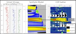
The dipole sonic log from Umiat #18 provided data to create a full-offset synthetic model to determine whether hydrocarbons within the existing reservoir were responsible for generating an AVO response. The model revealed a significant AVO response within the lower Grandstand interval, which was the only zone that had a substantial oil show in the well (Fig. 8). No other intervals in the model or in the seismic data produced a significant AVO response.
Gathers analyzed for an AVO response at the Umiat #7, which previous studies found to be wet in both sands of the lower and upper Grandstand intervals, detected no anomaly at that location. The value assigned to the AVO gradient magnitude results in uncertainty for this interpretation. Additional studies may shed light on this issue, but for the purposes of this analysis, scaling of anomalies in the mid-amplitude range provided room to scale up or down the overall acreage size of the features.
Tukkuttok prospect below permafrost
Umiat oil field was initially discovered using conventional geological methods, with wells Umiat #7 and Umiat #11 defining the down-dip reserve limits of the 7,000-acre closure on the crest. Based on these findings, operators at the time saw no need to drill further down dip in search of additional reserves.
However, the current AVO analysis of 3D seismic data identified about 9,000 acres of potential pay in the lower Grandstand interval, with an additional 3,500 acres in the upper Grandstand interval and 3,000 acres in the Ninuluk interval. A large portion of these anomalies are in the southwest corner of the 3D survey area, now referred to as the Tukkuttok prospect, which is currently unleased.
The discovery of the Tukkuttok prospect could have implications for Alaska’s oil landscape. If these newly identified anomalies are confirmed to contain significant oil volumes, the field’s total oil in place could exceed 2 billion bbl, doubling previous estimates.
Unlike the shallow low-pressure reservoirs discovered in the 1940s and 1950s, the oil within the Tukkuttok prospect is at 2,000–4,000 ft depths. These deeper reservoirs exist below the permafrost zone, which could help mitigate the production difficulties that plagued earlier attempts.
The presence of normal pressure conditions at these depths further enhances the potential feasibility of commercial production. Shallow oil reservoirs in permafrost have historically faced problems such as ice formation within the wellbore and low reservoir energy. The deeper hydrocarbon accumulations discovered through AVO analysis, however, are expected to behave more like conventional reservoirs with improved flow characteristics.
The quality of the crude oil is another potential advantage of the Tukkuttok prospect. Umiat’s oil is a light crude with 35°API gravity, making it more valuable and easier to refine than heavier crude oils found in other parts of the world. This high-quality oil could provide economic incentives for future development and investment in the region.
Acknowledgement
The authors thank Josh Rosera, Josh Coyan, and Clint Scott of the USGS for their thoughtful reviews and comments on this work.
References
- Houseknecht, D.W. and Bird, K.J., “Oil and gas resources of the Arctic Alaska petroleum province,” US Geological Survey Professional Paper 1732-A, 2006.
- Houseknecht, D.W., Whidden, K.J., Connors, C.D., Lease, R.O., Schenk, C.J., Mercier, T.J., Rouse, W.A., Botterell, P.J., Smith, R.A., Sanders, M.M., Craddock, W.H., DeVera, C.A., Garrity, C.P., Buursink, M.L., Karacan, C.O., Heller, S.J., Moore, T.E., Dumoulin, J.A., Tennyson, M.E., French, K.L., Woodall, C.A., Drake, R.M., II, Marra, K.R., Finn, T.M., Kinney, S.A., and Shorten, C.M., “Assessment of undiscovered oil and gas resources in the Central North Slope of Alaska, 2020,” US Geological Survey Fact Sheet 2020–3001, Jan. 23, 2020.
- Hanks, C., “Producing Light Oil from a Frozen Reservoir: Reservoir and Fluid Characterization of Umiat Field, National Petroleum Reserve, Alaska,” University Of Alaska Systems, February 2013.
- Collins, F.R., Bergquist, H.R., Brewer, M.C., and Gates, G.L., “Test Wells, Umiat Area Alaska,” US Geological Survey Professional Paper 305-B, 1958.
- State of Alaska, Department of Natural Resources, Division of Oil & Gas, AS 43.55 Exploration Tax Credit Project, 2017.
- 88 Energy Ltd., “Umiat Oil Field – Update,” Financial Times, Aug. 4, 2021.
- Chopra, S. and J. P. Castagna, “AVO,” Society of Exploration Geophysicists Investigations in Geophysics, Tulsa, Okla., No. 16, 2014.
- Miller, R.D., “Normal moveout stretch mute on shallow-reflection data,” Geophysics, Vol. 57, No. 11, 1992.
- U.S. Geological Survey, National Petroleum Reserve, Alaska, (NPRA) Legacy Data Archive, 2019.
About the authors
Paul McColgan is a geophysicist for McColgan Seismic Interpretation Services LLC and specializes in prestack seismic interpretation. He received a BS (1994) in geosciences from Pennsylvania State University, an MS (1999) from Wright State University, and a Ph.D. (2009) from the University of Oklahoma in geophysics.
Nilesh Dixit is the Graduate Program Director and Assistant Teaching Professor in the Biological Data Science MS program at Arizona State University’s School of Mathematical and Natural Sciences. He earned his B.Tech. (2007) in Instrumentation from Pune University, an MS (2010) in Marine Geosciences from the University of Plymouth, and Ph.D. (2017) in Geophysics from the University of Alaska Fairbanks.
Jacob T. Murchek is a Ph.D. candidate in geophysics at Michigan Technological University and a pathways intern at USGS where his research focuses on critical mineral and energy resources. He received a BS (2018) in chemistry from Purdue University and an MS (2021) in earth science from Wright State University.