Study links water injection, induced seismicity in Central and Northwest Oklahoma
Jeremy Boak
Oklahoma Geological Survey
Norman, Okla.
Injection into the Arbuckle group, the stratigraphic unit lying directly on Oklahoma's crystalline basement, is the likely cause of the state's earthquakes. The largest volume of injection has been into this horizon and increases of pore pressure in the Arbuckle are interpreted as transmitting to blind faults in the crystalline basement.
Oklahoma experienced an average of 1.6 earthquakes of Magnitude 3 or greater (M3.0+) from the 1980s through 2008. Seismicity increased to 903 M3.0+ earthquakes in 2015. Earthquake frequency declined in 2016, even though Oklahoma experienced its largest earthquake (M5.8) on Sept. 3, 2016, near Pawnee. Combined with an M5.1 event in northwest Oklahoma, Feb. 13, 2016, and an M5.0 earthquake near Cushing on Nov. 6, 2016, more seismic energy was released in 2016 than in any year in the state's history.
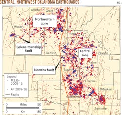
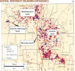
More than 95% of these earthquakes happened over only ~17% of the area of Oklahoma (Fig. 1). Seismic activity occurred in two main regions, a central zone to the east of the major Nemaha fault, comprising parts of nine counties mostly north of Oklahoma City and west of Tulsa, and a zone northwest of the fault, comprising parts of six counties.
The pattern of increased earthquake activity is generally attributed to increased injection of produced water in salt water disposal wells. Most of the injection occurred in the commonly underpressured and relatively permeable Arbuckle group, directly on top of the Precambrian crystalline basement.1 Pressure communication from the Arbuckle to faults in the basement reduced effective normal stress on the faults. This stress reduction allowed movement in faults aligned favorably with respect to the maximum horizontal stress (SHMax) field in Oklahoma (SHMax = N 85° E).
This paper discusses Oklahoma's seismicity evolution, the regulatory actions taken to decrease seismicity by reducing deep injection, and the importance of declining oil prices in cutting injected volumes in advance of full implementation of these regulations.
Oklahoma's induced seismicity
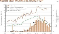
Fig. 2 shows rising earthquake frequency from 2011 through early November 2016. It shows the daily frequency of M2.8+ earthquakes averaged monthly and plots a 6-month moving average of these values. Activity increased to 24 M2.8+ earthquakes in 2009, from an historical annual average of 2.9.
Activity increased to 60 and 110 earthquakes in 2010 and 2011, respectively. The sharp increase was associated largely with seismic activity preceding and following the M5.7 Prague earthquake in November 2011, which damaged numerous homes, injured several people, and sparked debate about the earthquakes' origin. After the Prague swarm, earthquake activity slowed in 2012 (2.8+ = 63), but rose again in 2013 (M2.8+ = 184) and still more in 2014 (M2.8+ = 951), leading to protests and more political debate.
Both the central and northwestern areas where earthquakes swarmed are home to oil and gas plays with large amounts of coproduced water, most of which was disposed of in Underground Injection Class II Salt Water Disposal wells near producing fields. Injection volumes reached 1.5 billion bbl in 2014.2 Fig. 2 illustrates the rapid increase in injection in the 14 counties where >95% of the seismic activity has occured. Seismicity increased first in the southern part of the central area, then expanded northward and westward into the northwestern area.
Earthquake response
By the end of 2014, when 1,533 M2.8+ earthquakes had occurred, the Oklahoma Corporation Commission (OCC) began to shut in disposal wells and reduce injection in other wells in sensitive areas. OCC requested in early 2015 that operators of about 500 injection wells in the area of greatest seismic activity show they were not injecting directly into the basement, plug-back out of the basement, or cut injection by 50%. Also in early 2015, the Oklahoma Geological Survey (OGS) published a position statement that clearly attributed the increased seismic activity to deep injection of produced water through pressure communication to the deep basement.3 Additional actions taken generally in response to earthquakes of M4.0+ called for reduction of injection in many of these same wells.
Fig. 2 also shows injection rates for 684 wells completed in the Arbuckle group within the seismically active zone that reported injection data for 2011 through 2016 in response to OCC's accelerated reporting request. It documents a substantial decrease in injection beginning at the end of 2014, largely driven by the market's reaction to low oil prices.
Also shown on the chart are monthly Oklahoma crude oil production data from the US Energy Information Administration. Oklahoma oil production slightly declined in 2015 but increased in 2016, suggesting that other plays took the place of production lost in the water-rich plays that generated much of the salt water disposed of in the seismic area.
Galena Township fault
Despite the OCC-directed reductions, 2015 seismic activity climbed to 1,533 M2.8+ earthquakes. A November 2015 surge in seismic activity began on a fault in southern Woods County more than 12 km from the main area of injection in northern Woods, Alfalfa, and Grant Counties. The Galena Township fault went on to source about 75% of all seismic movement in Oklahoma in January and 85% in February (Fig. 1). Through August 2016, the biggest seismic events included three M4.0+ earthquakes in the first week of January, an M5.1 earthquake in February, and three M4.0+ aftershocks of that earthquake in July, all on the Galena Township fault.
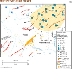
Fig. 3 shows both the earthquakes' epicenters and the area of higher injection-rate wells to the north.4 While seismic events occurred near the high-rate injection wells, no earthquake was as large as the main shock on the Galena Township fault.
Fault characteristics and not the degree of pore pressure enhancement from injection determined the magnitude of induced earthquakes. Changes in injection rate will most likely affect the frequency of earthquakes, but not the magnitude.
Earthquake frequency decline began in mid-2015 in the central area, and somewhat later in the northwest area. In the central area, which experienced 14 M4.0+ earthquakes in 2015, an M4.2 earthquake on Dec. 31, 2016, was followed by 88 days with no M4.0+ earthquakes. The northwest area experienced a batch of larger earthquakes in late 2015, amid a trend of generally decreasing activity.
The frequency of M2.8+ earthquakes on the Galena Township fault in the northwestern zone increased in 2015. The 180-day running average of such earthquakes peaked at near 4.5/day in mid-2015, before slipping to about 4.0 by late April. From there, it declined to about 2.3 by the end of September, despite bursts of activity in the northwestern zone in July and a Pawnee earthquake swarm in September. M2.8+ earthquakes' rate began a rapid decline in May 2016.
Pawnee, Cushing
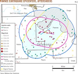
The Sept. 3, 2016, M5.8 earthquake occurred in Pawnee County on the eastern edge of the central zone. Pawnee had experienced relatively few earthquakes over the period of increased activity, and its neighbor, Osage County had experienced almost no earthquakes (Fig. 4).
This earthquake caused localized damage in Pawnee and was felt throughout much of the US mid-continent. The location of the main shock and early aftershocks placed it on a previously identified fault.5 Subsequent aftershocks defined an additional previously unidentified fault, and the OCC was forced to revise its initial order, shutting in additional wells, but also changing the wells it had directed to cut back on injection. The US Environmental Protection Agency, which regulates salt water disposal in Osage County based on its governance by Osage Nation, followed OCC's lead and shut in additional wells there.
The Nov. 7, 2016, M5.0 Cushing earthquake brought the 2016 total to an unprecedented three M5.0+ earthquakes. All four recent M5.0+ earthquakes (including the M5.7 Prague event of 2011) occurred near the edges of the two main seismic regions.
The occurrence of three M5.0+ earthquakes against a pattern of decline for nearly all other magnitude groups goes against the current trend. There were 1,026 M2.8+ earthquakes in 2016, a nearly one-third reduction from 1,533 in 2015. For M3.0+ earthquakes, the count was 623 in 2016, a reduction of 280 (31%) from the 903 in 2015.
Commission actions
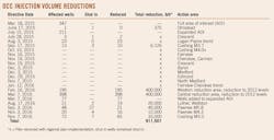
The OCC has taken steps to reduce injection of produced formation water across most of the earthquake-prone area, issuing a series of directives calling for changes in injection practices in response to the evolving seismic activity (Table). The team addressing the earthquake issue defined an earthquake-prone area of interest that encompassed a very large fraction of the earthquakes. This area increased in size as earthquakes continued, but has been stable since early 2016.
Surveying future events
The average depth of the earthquakes in Oklahoma has been 5.4-5.5 km, indicating that most of the state's seismicity occurs within its crystalline basement.6 Elevated seismic activity induced by oil and gas operations in Oklahoma is likely to continue through 2017. A decrease in earthquakes will likely depend on the activity along the Galena Township fault and on faults responsible for the Pawnee and Cushing earthquakes.
With all three large 2016 earthquakes happening in these zones, uncertainty remains about the frequency and magnitude of future earthquakes, and their potential for damage. Each of the M5.0+ events resulted in some damage, but the initial damage from a moderate (M4.0+) earthquake aggravated by cumulative shaking from numerous smaller earthquakes has not been evaluated, and remains an issue for the state.
Acknowledgments
The author acknowledges the support of many staff members of the Oklahoma Geological Survey, particularly hydrogeologist Kyle Murray, acting lead seismologist Jefferson Chang, and Austin Holland and Amberlee Darold, who built much of the present OGS seismic network and established the framework for understanding Oklahoma earthquakes.
References
1. Walsh, F.R. and Zoback, M.D., "Oklahoma's recent earthquakes and saltwater disposal," Science Advances, Vol. 1, No. 5, June 18, 2015.
2. Murray, K., "Class II Saltwater Disposal for 2009-2014 at the Annual-, State-, and County- Scales by Geologic Zones of Completion, Oklahoma," Oklahoma Geological Survey Open File Report OF5-2015, December 2015.
3. Andrews, R.D. and Holland, A.A., "Statement on Oklahoma Seismicity," Oklahoma Geological Survey, April 21, 2015.
4. Yeck, W.L., Weingarten, M., Benz, H.M., McNamara, D.E., Bergman, E.A., Herrman, R.B., Rubinstein, J.L., and Earle, P.S., "Far-field pressurization likely caused one of the largest injection induced earthquakes by reactivating a large preexisting basement fault structure," Geophysical Research Letters, Vol. 43, No. 19, Oct. 16, 2016.
5. Darold, A.P., Holland, A.A., Morris, J.K., and Gibson, A.R., "Oklahoma Earthquake Summary Report 2014," Oklahoma Geological Survey Open File Report OF1-2015, February 2015.
6. Darold, A.P. and Holland, A.A., "Preliminary Optimal Oklahoma Fault Orientations," Oklahoma Geological Survey Open File Report OF4-2015, July 2015.
The author
Jeremy Boak ([email protected]) is the state geologist and director of the Oklahoma Geological Survey in Norman, Okla. He was director of the Center for Oil Shale Technology and Research at the Colorado School of Mines, and before that worked at Los Alamos National Laboratory, The US Department of Energy's Yucca Mountain Project, and ARCO Oil and Gas. He holds BA, MS, and PhD degrees from Harvard and an MS from the University of Washington, all in geological sciences. He is a member of the American Association of Petroleum Geologists and Geological Society of America.
