New study expands understanding of Central-South Atlantic breakup

Yannis Bassias
Amphore Energy Inc.
Houston
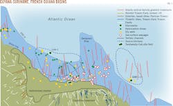
Observed NNW-SSE lineaments represent old faults reactivated during Cretaceous E-W drift that helped create a favorable Tertiary-to-present structural and depositional environment for southward, shoreward hydrocarbon migration in the South American Central Equatorial Atlantic margin. This margin covers the exclusive economic zones of Guyana, Suriname, and French Guiana, and extends across the eastern border of Venezuela and the northern border of Brazil. Geological parallels between the Brazilian and West African margins have led to optimism regarding the Atlantic margin's hydrocarbon potential in the past 20 years. The margin has two active petroleum systems confirmed in the basins of Guyana-Suriname and French Guiana (Fig. 1).
These petroleum systems share at least one reservoir with Venezuela and West Africa, but the margin's hydrocarbon migration mechanisms remain unclear. This article expands understanding of the Central-South Atlantic breakup's historical effects on contemporary migration pathways. It also compares basement structural framework with satellite derived vertical gravity gradient and identifies the distribution of seepages near shows and production sites to better understand onshore extrapolation of the migration process.
Recent activity
Faults lying NNW-SSE of Early Jurassic age were reactivated during the Cretaceous E-W drift and created favorable Tertiary-to-present structural and depositional trends of the same direction. These trends privileged southwards migration toward the shore. Hydrocarbons then traveled along preferential paths to the surface.
Production (16,000 b/d) in this large equatorial area comes from shallow heavy oil reservoirs onshore Suriname. More than 25 wells have also been drilled offshore Suriname and Guyana in an area exceeding 170,000 sq km.1 2 Several on the shelf and in shallow water either had noncommercial shows or were positioned off-structure. The most successful well was the Liza-1 discovery by ExxonMobil Corp. on Stabroek block 120 miles off Guyana. The 17,835-ft exploration well was drilled in 5,719 ft of water and encountered 295 ft of oil-bearing sandstone reservoirs (OGJ Online, May 20, 2015).
Seven wells were drilled in a 27,000-sq-km area off the coast of French Guiana but with generally disappointing results. One exception was Zaedyus (GM-ES-1) drilled in 2,048 m of water by Tullow Oil PLC in 2011. The 5,711-m well encountered 72 m of oil bearing turbidites at the eastern slope of the Demerara Plateau (OGJ Online, Sep. 9, 2011).
Deep lineaments, early rifting
A network of NNW-SSE lineaments appears along the Atlantic margin coast on offshore vertical gravity data (Fig. 2). These lineaments denote relics of deep faulting associated with the early rifting of the Central Atlantic Ocean in Early Jurassic (190-170 million years).
These satellite-derived vertical gravity gradients represent variations in the subsurface and beneath the ocean. Vertical gravity gradients are a high-pass filtered version of gravity that reveals seamounts and plate boundaries in areas where bathymetry data are not available.3 Along the Suriname coast, studies have observed the graben-rift system in the ENE-WSW direction, perpendicular to the NNW-SSE lineaments, with around 60° strike to the coast (in yellow on Fig. 2).2 This feature is related to the early rifting event several researchers have investigated.4-10
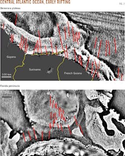
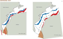
The same lineaments are on the southern edge of Florida's peninsula (F on Fig. 2) and seem to be concomitant with the direction of the initial break up between North America and Africa at 190 million years (Fig. 3). This occurred before a change in plate motion from NNW-SSE to NW-SE at 170 million years.10
The reconstruction in Fig. 3 suggests North America is fixed. The blue and red zones represent the coastal magnetic anomalies of North America's east coast and Africa's west coast. The dashed blue line represents the Blake Spur magnetic anomaly. G, D, and F represent respectively the Guinea plateau, Demerara plateau, and Florida peninsula.
Cretaceous stress release
During Late Jurassic-Early Cretaceous (170-120 million years) the rifting progressed to the south and a transtensional regime released the stress along the coast of Guyana-Suriname-Guiana, allowing Africa and South America to drift apart along transform fault systems. During this EW stretching part of the NNW-SSE motion, faults were reactivated, leading to extensional structures and creating space for the emplacement of tholeitic dikes (Fig.1).
These tholeitic dikes were mapped onshore French Guiana and Suriname and encountered on several wells described as basement.11-14 From Late Cretaceous the equatorial margin remained thermally and structurally undisturbed, which developed Eocene and younger sand deposits in both shelf and deepwater environments and built future reservoirs.
Source rock, seepage concentration
Cretaceous sediments from onshore wells in Suriname, east of the Tambaredjo block, have biomarkers indicating a Jurassic or Lower Cretaceous-age petroleum system with a maturity window starting around 90 million years.2 The rock types indicate a different source rock than that of the Tambaredjo and Calcutta producing fields, which produce from Cenomanian-Turonian. This Type II marine source rock (Canje formation, similar to the La Luna shale) shows maturity initiating much later, at 45-40 million years, and migration is mainly SSE on the tracks of the mapped Cretaceous and Early Tertiary channels.2
Landsat and Spot optical and radar images detected both concentrations of oil-slick areas of light oil and high seep densities in the eastern portion of Suriname's offshore and the western portions of French Guiana's.2 Seepage density distribution is consistent with the following:
• Direction of the Late Cretaceous and Early Tertiary channels.
• Range of the Aptian top surface that represents the major carrier bed.
• Deep NNW-SSE faulting direction detected on gravity maps.
• Distribution of shows in wells.
These features indicate a preferential SSE direction of migration towards the coast of the larger Guyana equatorial margin. West of the Demerara plateau, an evident correlation exists between the NNW-SSE deep lineaments, oil shows in the wells, seepage locations at the water surface, and most likely the onshore production of heavy oil. East of the Demerara Plateau we note that the wells are located close to the observed lineaments (Fig. 1). The Late Tertiary channel system of the margin has a southward direction and the seepage density is concentrated close to the neck (updip) rather than the mouth (downdip) of these channels.
Cretaceous, Eocene reservoirs
The observed NNW-SSE lineaments are Early Jurassic faults that were reactivated during Cretaceous E-W drift and helped create a favorable Tertiary-to-present structural and depositional environment for southward, shoreward hydrocarbon migration. This hypothesis is supported by the fact that the margin's Late Tertiary channel system has a N-S direction and the seepage density is concentrated close to the neck updip rather than the mouth of the channels.
Further understanding of this mechanism and a large surface geochemistry sampling will identify advantageous locations along the entire equatorial margin where the preservation of offshore Cretaceous and Eocene reservoirs occurs.
References
1. "International Competitive Bid Round 2013, The Demerara Plateau-An Exploration Opportunity in Offshore Suriname," Staatsolie NV Annual Report 2012, Apr. 14, 2013.
2. "Suriname, The Next Giant Plateau," Staatsolie NV, American Association of Petroleum Geologists International Conference and Exhibition, Singapore, Sept. 16-19, 2012.
3. Sandwell, D.T., Satellite Geodesy, Scripps Institution of Oceanography, University of California, San Diego, topex.ucsd.edu/marine_topo.
4. Guyet, S., Unternerh, P., and Mascle, A., "The French Guiana margin and theDemerara Plateau: Geological History and Petroleum Plays," Special Publication of the European Association of Petroleum Geoscientists, No. 4, 1994, pp. 411-422.
5. Pindell, J. and Dewey, J.F., "Permo-Triassic reconstruction of western Pangea and the evolution of the Gulf of Mexico/Caribbean region," Tectonics, Vol. 1, No. 2, April 1982, pp. 179-211.
6. Pindell, J., Kennan, L., Sanek, K.P., Maresch, W.V., and Draper, G., "Foundations of Gulf of Mexico and Caribbean evolution: Eight controversies resolved," Geologica Acta, Vol. 4, No. 1-2, 2006, pp. 303-341.
7. Greenroyd, C. J., Peirce, C., Rodger, M., Watts, A.B., and Hobbs, R.W., "Crustal structure of the French Guiana margin, West Equatorial Atlantic," Geophysical Journal International, Vol. 169, No. 3, June 2007, pp. 964-987.
8. Greenroyd, C.J., Peirce, C., Rodger, M., Watts, A.B., and Hobbs, R.W., "Demerara Plateau - the structure and evolution of a transform passive margin," Geophysical Journal International, Vol. 172, No. 2, February 2008, pp. 549-564.
9. Bird, D., and Burke, K., "Pangea breakup: Mexico, Gulf of Mexico, and Central Atlantic Ocean," expanded abstract, Society of Exploration Geophysicists, January 2006.
10. Labais, C., Olivet, J.L., Aslanian, D., and Roest, W., "An alternative early opening scenario for the Central Atlantic Ocean," Earth and Planetary Science Letters, Vol. 297, No. 3-4, September 2010, pp. 355-368.
11. Delor, C., Lahondere, D., Egal, E., Lafon, J.M., Cocherie, A., Guerrot, C., Rossi, P., Truffert, C., Theveniaut, H., Phillips, D., and De Avelar, V.G., "Transamazonian crustal growth and reworking as revealed by the 1:500,000-scale geological map of French Guiana," 2nd edition, Géologie de la France, No. 2-3-4, 2003.
12. Geological Map of the French Guiana at 1:500,000 scale, BRGM (2003), edition BRGM.
13. Geological Map of Suriname at 1:500 000 scale (1977): Geologisch Minsbouwkundige Dienst, Amsterdam.
14. Veldkamp, J., "Gravity Surveys in Suriname and the Netherlands Leeward islands area, 1958-1965," Netherlands Geodetic Commission, Publications on Geodesy, Vol. 3, No. 3, 1969, pp. 1-77.
EXPLORATION &
DEVELOPMENT
The author
Yannis Bassias ([email protected]) is president of Amphore Energy Inc., Houston, and works on frontier exploration areas of the Indian and Atlantic Oceans. He has also served as president and CEO of Georex from 1997-2012. Before joining the petroleum industry he was associate professor in the National Museum of Natural History, Paris. He holds a PhD (1984) from the University Pierre et Marie Curie, Paris. He is a member of the American Association of Petroleum Geologists, the Society of Exploration Geophysicists, the Petroleum Exploration Society of Great Britain, and the Association of International Petroleum Negotiators.