Multiple stacked plays drive continued Permian development

Kristen Marra
Stephanie Gaswirth
US Geological Survery
Lakewood, Colo.
The exploitation of unconventional (continuous) resource plays with horizontal drilling and fracturing techniques continues to spur renewed development in mature producing basins in the US. The Permian basin of west Texas has emerged as a particularly strong prospect due to the potential for multiple stacked resource plays in formations such as the Wolfcamp shale and Spraberry and Bone Spring formations.
Production began in the Permian basin in the early 1920s, and more than 116,000 wells have been drilled in Midland basin alone.1 2 In 2017, total Permian basin oil production climbed to nearly 1.7 million b/d.3
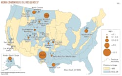
The US Geological Survey (USGS) conducts geologic-based assessments of undiscovered, technically recoverable domestic hydrocarbon resources. The USGS recently assessed the Wolfcamp shale in the Midland basin portion of the Permian basin for continuous (unconventional) oil and gas resources, and completed a reassessment of the Spraberry formation for both continuous and conventional oil and gas.4 5 Combined, the assessments of the Spraberry formation and underlying Wolfcamp shale in Midland basin comprise the largest domestic continuous oil assessment in the contiguous US (Fig. 1).
Spraberry Wolfcamp
The Early Permian Spraberry formation lies exclusively within Midland basin, the eastern sub-basin of the greater Permian basin in southwest Texas. The underlying Pennsylvanian-Permian Wolfcamp shale is found within both the Midland and Delaware basins and extends across the Central Basin Platform. The Bone Spring formation is considered the lateral and time-equivalent of the Spraberry in Delaware basin.6
The Wolfcamp shale was deposited during the Pennsylvanian-Permian as predominantly carbonates on the Eastern shelf and Central Basin Platform and as interbedded organic-rich siliciclastic mud, organic-poor clay-rich mud, and fine-grained carbonates within the Midland Basin.6 The overlying Spraberry Formation was generally deposited as a large-scale submarine fan system, and consists of interbedded sandstone, siltstone, carbonate, and organic-rich shale. Detrital limestone deposits occur along the margins of the basin.6 7
The Spraberry formation of Midland basin has been producing oil and gas since the early 1950s and was historically developed with vertical wells. Drilling and perforation depths have generally increased over time during Spraberry development, allowing for commingling of multiple intervals of the Spraberry formation, as well as with the underlying Wolfcamp shale. The combined drilling of the Spraberry and Wolfcamp produced the informal “Wolfberry” play across the Spraberry (trend area) field.6
In recent years, horizontal drilling, coupled with hydraulic fracturing techniques, allowed development of individual horizons within both the Spraberry formation and Wolfcamp shale. The Wolfcamp shale is informally divided by industry into the Wolfcamp A, B, C, and D horizons, where A is the uppermost unit. In general, industry has been focused on horizontal exploitation of the Wolfcamp A and B units.4
The Spraberry formation is informally divided into upper, middle, and lower Spraberry intervals. Operators are specifically targeting the middle and lower Spraberry, with particular development emphasis on the lower Spraberry due to higher proportions of shale and organic matter. The lower Spraberry is further divided by some operators into the informal lower Spraberry shale and lower Spraberry. Within the upper section of the lower Spraberry, a silt-rich interval referred to as the “Jo-Mill” by industry, is also considered a specific horizontal drilling target. For the 2017 USGS geologic resource assessment, however, the Spraberry formation is separated only into the informal upper, middle, and lower intervals.5 6
Geologic assessment
The Spraberry formation was previously assessed by the USGS in 2007 as part of a larger assessment of the greater Permian basin. In the 2007 assessment, two assessment units (AUs) were defined for the Spraberry formation: 1) Spraberry Continuous Oil AU and 2) Spraberry Conventional Sandstone AU. The quantitative assessments of these AUs were based on vertical drilling development in Midland basin.8 The Wolfcamp shale had not been previously assessed for continuous resources before 2016 by the USGS; however, the Wolfcamp was assessed as part of combined Pennsylvanian-Lower Permian strata for conventional resources in 2007.8
In 2017, the Spraberry Formation AUs were redefined to include wells that have been drilled to the perimeter of the basin and beyond the previously established Spraberry (trend area) field. In addition, two separate AUs were defined within the continuous Spraberry formation region to account for current horizontal drilling into the informal lower and middle Spraberry intervals. In total, three new assessment units were defined for the Spraberry formation in Midland basin:
• Lower Spraberry Continuous Oil Trend AU.
• Middle Spraberry Continuous Oil Trend AU.
• Northern Spraberry Conventional AU (Fig. 2).
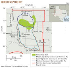
The Upper Spraberry interval, consisting predominantly of sands, was not included in this assessment due to spacing issues related to extensive vertical drilling development in the play.5
The assessment methodology in 2017 incorporated the recent shift to horizontal drilling technology in the Spraberry continuous AUs, which changes both the per well estimated ultimate recovery (EUR) and well spacing projections used in the assessment calculations. The mean EUR for a Spraberry horizontal well was calculated at 0.13 million barrels of oil (MMBO) for the Middle Spraberry Continuous Oil Trend AU and 0.18 MMBO for the Lower Spraberry Continuous Oil Trend AU, based on limited well data.5 In contrast, the mean EUR projected for a vertical Spraberry well at the time of the 2007 assessment was approximately 0.05 MMBO. A reevaluation in 2017 by the USGS of the mean EUR for a vertical Spraberry well in the continuous region of the play increased the estimate to 0.08 million barrels of oil.5 8
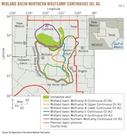
The Wolfcamp shale was divided into a total of six AUs:
• Midland Basin Wolfcamp A Continuous Oil AU.
• Midland Basin Wolfcamp B Upper Continuous Oil AU.
• Midland Basin Wolfcamp B Lower Continuous Oil AU.
• Midland Basin Wolfcamp C Continuous Oil AU.
• Midland Basin Wolfcamp D Continuous Oil AU.
• Midland Basin Northern Wolfcamp Continuous Oil AU (Fig. 3).
The differences in AU extents among the various horizons were primarily based on depositional limits and thicknesses throughout Midland basin, where the formation is mature for oil generation. The average calculated EURs for the Wolfcamp shale based on limited well data was 0.10-0.14 MMBO, with the highest EURS estimated within the Wolfcamp A and B horizons. To account for potential future enhanced recovery, the mean EURs for the Wolfcamp A and B intervals were estimated at 0.17 MMBO (with a probability range of 0.12-0.30 MMBO) for the purposes of the assessment. The mean Wolfcamp A and B EURs are comparable to those calculated for the lower and middle Spraberry intervals.4 5
Total oil resource
The mean estimated total resource of the 2017 Spraberry formation was 4.2 billion bbl of oil and 3.1 tcf of gas. The majority of this resource assessment is attributed to the two Spraberry continuous AUs (Middle Spraberry Continuous Oil Trend AU and Lower Spraberry Continuous Oil Trend AU), as a mean of 5 million bbl was assessed for the Northern Spraberry Conventional AU. In comparison, the mean total assessed in 2007 for continuous and conventional resources of the Spraberry formation (based on vertical wells) was 530 million bbl of oil.5 8
The underlying continuous resources of the Wolfcamp shale in Midland basin were assessed for the first time by the USGS in 2016, resulting in mean totals of 20 billion bbl of oil and 16 tcf of gas within six continuous AUs. Combined with the historically prolific Spraberry formation, the total mean undiscovered, technically recoverable oil resource is 24.2 billion bbl for these stacked reservoir intervals in Midland basin.4 5
In 2013, the USGS released an updated assessment of the Bakken and Three Forks formations in Williston basin, which estimated a total mean of 7.4 billion bbl of oil. At the time, this was the largest domestic oil assessment conducted by the USGS. The addition of the Heath formation, assessed in 2016, raises the total assessed continuous oil resources in Williston basin to 7.6 billion bbl of oil.9 10 The recent assessments of the Spraberry and Wolfcamp formations in the Midland basin nearly tripled the Bakken, Three Forks, and Heath formations’ mean assessment due to horizontal exploitation of thick, stacked reservoir intervals.
Midland basin contains the largest estimated assessed continuous oil resource by the USGS. Additional assessments are underway in neighboring Delaware basin that will ultimately alter the total mean resources projected by the USGS for the greater Permian basin.
References
1. Farnsworth, B., “Permian Basin enters its second act,” Hart Energy E&P, Apr. 29, 2015.
2. Blomquist, P.K., “Wolfcamp horizontal play, Midland Basin, West Texas,” [abs.], American Association of Petroleum Geologists Search and Discovery Article #10890, Nov. 28, 2016.
3. Texas Railroad Commission, “Texas Permian Basin Oil Production 2008 through November 2017,” http://www.rrc.state.tx.us/media/41514/permianbasin_oil_perday.pdf (accessed February 2018).
4. Gaswirth, S.B., Marra, K.R., Lillis, P.G., Mercier, T.J., Leathers-Miller, H.M, Schenk, C.J., Klett, T.R., Le, P.A., Tennyson, M.E., Hawkins, S.J., Brownfield, M.E., Pitman, J.K., and Finn, T.M., “Assessment of undiscovered continuous oil resources in the Wolfcamp Shale of the Midland Basin, Permian Basin Province, Texas, 2016,” US Geological Survey Fact Sheet, November 2016, 2016-3092.
5. Marra, K.R., Gaswirth, S.B., Schenk, C.J., Leathers-Miller, H.M., Klett, T.R., Mercier, T.J., Le, P.A., Tennyson, M.E., Finn, T.M., Hawkins, S.J., and Brownfield, M.E., “Assessment of undiscovered oil and gas resources in the Spraberry Formation of the Midland Basin, Permian Basin Province, Texas, 2017,” US Geological Survey Fact Sheet, May 2017, 2017-3029.
6. Hamlin, H.S. and Baumgardner, R.W., “Wolfberry (Wolfcampian-Leonardian) deep-water depositional systems in the Midland Basin – Stratigraphy, lithofacies, reservoirs, and source rocks,” Bureau of Economic Geology, The University of Texas at Austin, Report of Investigations No. 277, 2012, p. 61.
7. Handford, C.R., “Sedimentology and genetic stratigraphy of Dean and Spraberry Formations (Permian), Midland Basin, Texas,” AAPG Bulletin, Vol. 65, No. 9, September 1981, pp. 1602-1616.
8. Schenk, C.J., Pollastro, R.M., Cook, T.A., Pawlewicz, M.J., Klett, T.R., Charpentier, R.R., and Cook, H.E., “Assessment of undiscovered oil and gas resources of the Permian Basin Province of West Texas and Southeast New Mexico, 2007,” US Geological Survey Fact Sheet, February 2008, 2007-3115.
9. Gaswirth, S.B., Marra, K.R., Cook, T.A., Charpentier, R.R., Gautier, D.L., Higley, D.K., Klett, T.R., Lewan, M.D., Lillis, P.G., Schenk, C.J., Tennyson, M.E., and Whidden, K.J., “Assessment of undiscovered oil resources in the Bakken and Three Forks Formations, Williston Basin Province, Montana, North Dakota, and South Dakota, 2013,” US Geological Survey Fact Sheet, April 2013, 2013-3013.
10. Drake, R.M., Schenk, C.J., Klett, T.R., Le, P.A., Leathers-Miller, H.M., Brownfield, M.E., Finn, T.M., Gaswirth, S.B., Marra, K.R., and Tennyson, M.E., “Assessment of undiscovered continuous oil and gas resources in the Heath Formation, Central Montana and Western North Dakota, 2016,” US Geological Survey Fact Sheet, June 2017, 2017-3032.
11. US Geological Survey, National Oil and Gas Resource Assessment Team, “1995 National assessment of United States oil and gas resources,” 1995, US Geological Survey Circular 1118, p. 20.
The author

Kristen R. Marra ([email protected]) is a research geologist with the Central Energy Resources Science Center at the USGS Denver office. Before joining the USGS in 2011, she worked for QEP Energy Co., Tulsa. Marra completed her BS (2005), MS (2008), and PhD (2015) degrees at the University of Oklahoma, Norman, Okla.

Stephanie B. Gaswirth ([email protected]) is a research geologist with the Central Energy Resources Science Center of the USGS in Denver. She worked for ExxonMobil Upstream Research Company prior to joining the USGS in 2006. Gaswirth holds degrees in geology: a BA (1997) from Franklin & Marshall College, Lancaster, Pa.; an MS (1999) from Rutgers University; and a PhD (2004) from the University of Colorado, Boulder.