Ultradeep shelf well logs four indicated pays in Miocene
The ultradeep Gulf of Mexico shelf well known as Blackbeard has logged four “potential hydrocarbon-bearing zones below 30,067 ft,” said operator McMoRan Exploration Co., New Orleans.
Having reached 32,997 ft in October, McMoRan and partners had to decide whether to halt drilling and attempt to test the zones encountered thus far or continue drilling to basement, expected below the permit depth of 35,000 ft, in an effort to penetrate at least another 2,000 ft of sediments.
It is too soon to tell whether the four zones, in the Miocene Rob-L formation, contain crude oil or gas-condensate, James R. Moffett, cochairman of McMoRan said on an Oct. 20 webcast. On Oct. 23, McMoRan said, “The well will be temporarily abandoned while the necessary long lead time completion equipment is procured for this anticipated high pressure test.”
How soon formation tests might take place wasn’t predicted.
Bottomhole pressure exceeds 25,000 psi, and the four zones exhibit the high resistivity seen in Rob-L elsewhere.
Moffett said, “No one ever tried to flow a well at these depths.” The well is presently cased to 27,000 ft.
About 18 months after previous operators gave up on the well after drilling to just below 30,000 ft, McMoRan’s group took over. It deepened the well routinely except for a 31/2-week period of lost returns, penetrated a normal stratigraphic section, and ran conventional logs to the new total depth, Moffett said.
Wide area impact
The well is on the crest of a massive structure covering more than 10,000 acres, and test results have implications out to a 50-mile radius of the well, Moffett said.
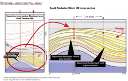
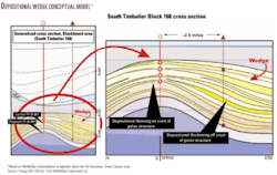
“Seismic data on the prospect indicates the potential for significantly thicker sands on the flanks of the structure as confirmed in recent major deepwater discoveries,” McMoRan said. “Based on information obtained to date in the South Timbalier Block 168 well, McMoRan believes additional drilling on the flanks could result in significant reserve potential.”
A drillsite 21/2 miles southeast of the Blackbeard well, for example, might encounter a depositional wedge in which the same formations are two to three times as thick as at the crest, Moffett said. The great thickness and large areal extent makes for large recoverables.
Moffett said this conclusion is based on McMoRan’s interpretation of data made public by the partners in the K2 deepwater field 90 miles south-southeast on Green Canyon Block 562, where sands were transported from the onshore Mississippi River Delta.
Operators naturally drill the top of structures in deep water because they lack well control and historically found the greatest chance for hydrocarbons is at the crest, Moffett noted.
McMoRan’s confidence in Blackbeard is further bolstered because it is exploring for the same formations as at its large Flatrock discovery in 10 ft of water on South Marsh Island Block 212 about 100 miles north-northwest of Blackbeard. The Rob-L formation encountered at 28,000-35,000 ft at Blackbeard is producing gas at 14,000-16,500 ft at Flatrock.
Flatrock discovery
Flatrock field, with five successful wells, is producing gas from Rob-L and the underlying Miocene Operc formation.
The Flatrock-6 delineation well, expected to spud in the current quarter, targets deeper Rob-L sands than those producing, Operc sands, and possibly the even deeper Miocene Upper Gyro sand section of the Flatrock/Hurricane Deep structure. It is projected to 19,700 ft and will probe the south half of Flatrock.
Successful wells can be placed on production quickly through Tiger Shoal field facilities.
McMoRan said the Flatrock-4 well tested 109 MMcfd of gas and 2,500 b/d of condensate on a 50/65-in. choke with 8,170 psi flowing tubing pressure. The same sand is producing 100 MMcfd in the Flatrock-2 well, which went online in July.
The first three Flatrock wells are producing a combined 170 MMcfed of gas and condensate, and wireline logs indicated 100 net ft of pay in the Rob-L section of the Flatrock-5 development well. That well is drilling towards 18,400 ft to deeper Rob-L and Operc sands.
A McMoRan group is also preparing to drill the Ammazzo prospect in South Marsh Island 251. It is 16 miles and 11 miles south-southeast of Flatrock and JB Mountain fields, respectively, and lies along the structural axis of a ridge trending from Flatrock. Objectives are the same three Miocene formations.
Ammazzo is one of the largest undrilled structures on the gulf shelf, McMoRan said.
Deep shelf economics
Moffett pointed out that the deep shelf play is not so price sensitive as onshore shale plays, for instance, because the reserves are large, the gas is found in conventional, soft rock that requires no horizontal drilling or frac treatments, and production infrastructure is everywhere.
The South Timbalier Block 168 No. 1 well, formerly Blackbeard West, is the deepest ever drilled below the mud line in the gulf. It is in 70 ft of water 115 miles southwest of New Orleans (see map, OGJ, June 7, 2004, p. 40). The prospect covers a number of leases in the South Timbalier and Ship Shoal areas.
McMoRan operates the well with 32.3% working interest. Plains Exploration & Production Co. and Energy XXI USA Inc., both of Houston, have 35% and 20%, respectively.
McMoRan is one of the largest acreage holders on the gulf shelf with rights to 1.5 million gross acres including 450,000 gross acres associated with the ultradeep trend.
AlbaniaStream Oil & Gas Ltd., Calgary, will plan a development program for Ballsh-Hekal and Gorisht-Kocul oil fields in Albania based on initial results of its well remediation work.
After starting the first phase of radial jetting on four wells in the two fields in mid-August, the company reported higher recovery rates from all wells through September. It placed progressive cavity pumps in the wells in October and will report production results once stabilized.
“In general a twofold increase in production from those wells is sustained and upon optimization of the PCP pump flow this can increase even further,” the company said.
Stream Oil & Gas also plans a second phase of radial jetting for Cakran-Mollaj field once the appropriate rig is mobilized early 2009, subject to the company’s ability to raise the required funds. It let a contract to Seismotech Ltd. to deploy microfracture monitoring equipment, initially at Cakran-Mollaj and then at the two other fields, to map preferential fracture zones around the wells and direct radial jetting accordingly.
New ZealandCanadian consulting engineers confirmed a prospective resource of a most likely 12.6 billion bbl of 50° gravity oil in the Paleocene Waipawa and Paleocene-Cretaceous Whangai fractured shales on two blocks held by Trans-Orient Petroleum Ltd., Vancouver, BC, in New Zealand’s lightly explored East Coast basin.
The consultants assigned the prospective resource on the basis of well log data, core pyrolysis, and the company’s field measurement of outcrops and oil and gas seeps.
Trans-Orient Petroleum holds 100% interest in PEP 38348 and 38349 totaling 2.2 million acres onshore in the basin, and the estimate is based on less than 10% of the acreage. Depth to the shales is 1,500-1,750 m.
SpainSaxon Oil Co. Ltd., a Canadian company based in Dallas, signed a definitive agreement in a transaction that would give Saxon the rights to a proposed coalbed methane project in northwestern Spain.
Saxon plans to buy the stock of Picogina Holdings BV, which owns 100% of Hidrocarburos del Cantabrico SL, a private company that holds full interest in five hydrocarbon exploration licenses totaling 237,000 acres in the Asturias region 225 miles northwest of Madrid.
HDC’s plan is to seal existing coal mines and extract methane to generate electricity. Saxon will ask its shareholders to vote on the acquisition on Nov. 20 and would close the purchase a few days later.
QuebecBrownstone Ventures Inc., Toronto, completed the acquisition of a farmout from X-Terra Resources Corp., Rouyn-Noranda, western Quebec, of three oil and gas licenses in Quebec’s St. Lawrence Lowlands.
Brownstone becomes operator with 50% interest in the Rimouski and Rimouski North licenses near Rimouski and the Shawi license on the St. Lawrence River north bank near Trois Rivieres. The licenses, to be explored for gas in Ordovician Utica shale, total 159,991 ha.
CaliforniaTri-Valley Corp., Bakersfield, plans to drill three more horizontal wells to shallow Pliocene Vaca tar sand at Pleasant Valley in Ventura County near Oxnard, Calif., where it has seven wells on cyclic steam production.
Tri-Valley was to begin cyclic steaming in late October at four existing vertical wells on the Lenox Ranch lease at Pleasant Valley. The vertical wells are not as productive as the company’s horizontal wells, but the 19 existing vertical wells drilled by a prior operator appear responsive to reworking.
A rig is expected to spud at Lenox Ranch in mid-November, and the company aims to drill at least 10 more Vaca horizontal wells there in 2009.
ColoradoThe US Fish & Wildlife Service, surface owner of the Baca National Wildlife Refuge in Saguache County, Colo., has issued a finding of no significant impact for the proposed Baca gas drilling project operated by Lexam Explorations Inc., Toronto.
The finding, which followed a 15-month review process, is the final approval required before Lexam can proceed with exploration, although legal challenges are possible.
Lexam drilled two exploration wells in the San Luis subbasin in the 1990s when the surface was privately owned and plans to drill two more with 75% interest and ConocoPhillips has 25% (OGJ, Sept. 1, 1997, p. 78). The F&WS acquired surface ownership in 2000 and operates the refuge.
New YorkNorse Energy Corp., Lysaker, Norway, reported having completed 11 successful gas wells in fractured Silurian Herkimer sandstone in south-central New York.
The company holds mineral rights to more than 130,000 acres in Broome, Chenango, and Madison counties. It estimates 1.2 bcf/well recoverable and has laid a gathering system near Norwich, northeast of Binghamton, in eastern Chenango County.
The wells have cut 250-380 ft of gross pay, and the company has identified 250 locations on seismic so far on its acreage. The company also plans to test the Ordovician Utica and Devonian Marcellus shales, which are indicated to be promising on logs.
PennsylvaniaCabot Oil & Gas Corp., Houston, is averaging 4-5 MMcfd of gas from five vertical Devonian Marcellus shale wells in northeastern Pennsylvania.
The company expects to exceed its goal of producing 6-9 MMcfd by the end of 2008.
Cabot completed its first horizontal well, which will be on line shortly, with only three of six planned fracs. The company will run the other three fracs in a few weeks.
Two more horizontal wells are cased awaiting completion, and five vertical wells are in various stages of completion, all of which are expected to be flowing to sales by yearend.
TexasGulf Coast
Calgary independents Sharon Energy Ltd. and Diaz Resources Ltd. took positions in the Cretaceous Eagle Ford shale play in South Texas.
Each firm reported acquiring 5,400 gross acres, and Sharon is operator with a 50% working interest with its partner in 4,250 net acres.
Sharon didn’t specify the location of its holdings but said they are on trend with a Petrohawk Energy Corp. gas-condensate discovery in LaSalle County and a large Apache Corp. drilling program (OGJ Online, Oct. 21, 2008).
Apache, with acreage in Washington, Burleson, and Brazos counties, has completed four horizontal Eagle Ford wells in Burleson at an initial 170-345 b/d of oil after four to nine frac stages each.
Sharon said its acreage has numerous existing wellbores that it believes can be reentered, horizontally drilled, and have staged fracs applied in the Eagle Ford. It is preparing a development plan.

