Report lists Arizona's oil, gas potential
This article is a summary of Arizona Geological Survey Circular 29, which contains detailed figures of each area, a descriptive tabulation of seeps and petroliferous rocks, and extensive references.
A wealth of evidence indicates that Arizona has potential for oil, natural gas, coalbed methane, helium, and carbon dioxide resources.
The evidence includes current production of oil and gas, past production, and recent discovery of the industrial gases helium and carbon dioxide, shows of oil, gas, and helium in wells, outcropping petroliferous rocks, oil seeps, and prospective areas with hydrocarbon source and reservoir rocks.
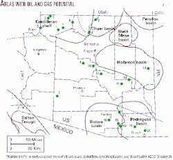
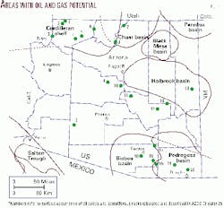
Eight areas have fair to excellent potential (Fig. 1). In addition, some Tertiary basins have evidence of source or reservoir rocks.
Production history
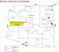
The earliest recorded attempt to find oil in Arizona was in 1905, when a dry hole was drilled in the Chino Valley, about 20 miles north of Prescott (Fig. 2). Kipling Petroleum Co. discovered helium about 40 miles east of Holbrook in 1950. Shell Oil Co. made the first oil discovery in 1954 when it drilled the 2 East Boundary Butte well in the Four Corners area.
To date 97 wells have produced oil, gas, or helium. Twenty-five wells currently produce oil and nine produce gas. Cumulative production from all wells is more than 20.5 million bbl of oil, 28.5 bcf of gas, and nearly 740 MMcf of 99.9% pure helium.
Land status, services
At 113,955 sq miles, Arizona is the sixth largest state.
Large blocks of state trust, public, and fee lands are available in several of the areas with potential.
All current production in Arizona is from Navajo Indian land. Past production of helium was from state trust and fee land.
The closest locations for most oilfield drilling, service, and supply companies are Farmington or Artesia, NM. Some companies have used drilling equipment from California, Texas, and Oklahoma.
Regulation, permitting
The Oil and Gas Conservation Commission (OGCC) regulates drilling and production in Arizona. The OGCC is attached administratively to the Arizona Geological Survey (AZGS).
Prior to drilling one must submit an application, bond, and a small filing fee to the oil and gas administrator at the AZGS. The bond is $10,000 or $20,000 depending on depth. A blanket bond for multiple wells is $25,000.
Petroleum geology
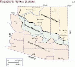
The landscape of Arizona consists of two physiographic regions separated by a transition zone that has elements common to both (Fig. 3).
The southern part of the Colorado Plateau makes up the northeastern 40% of Arizona. It is characterized by flat-lying, relatively undisturbed, largely marine sedimentary rocks of Paleozoic and Mesozoic age covered by Tertiary to recent volcanic flows near Flagstaff and Springerville. All current production, past production of helium, and the recent discovery of carbon dioxide are from rock formations in the Plateau province.
The Basin and Range makes up the southwestern 40% of the state. It is characterized by folded and faulted igneous, metamorphic, and marine sedimentary rocks of Precambrian to Mesozoic age that are exposed in north- to northwest-trending, linear mountain blocks (ranges). The mountains are separated by wide, deep valleys (basins) filled largely with deposits of Tertiary to Recent age.
The Colorado Plateau and Basin and Range provinces are separated by the Transition Zone, which includes at least two Tertiary basins that have not been conclusively drilled for oil and gas.
Hydrocarbon indications
Surface seeps, outcropping petroliferous rocks, and shows of oil and gas in wells are common in many parts of Arizona (Fig. 1). Surface seeps are commonly characterized by tar in fractures. Petroliferous rocks are characterized by a strong odor of petroleum on freshly broken surfaces. Some yield a faint cut fluorescence in 111-trichloroethane.
Shows of oil and gas in wells are documented in the well files and sample cuttings maintained by the AZGS. Shows range from oil stains on grains to oil bleeding from fractures in conventional cores. Free oil and oil-cut mud were reported in several wells.
Areas with potential
Areas with hydrocarbon potential are present in several sparsely drilled parts of Arizona.
Average drilling density in Arizona is about one well/100 sq miles. It is closer to one well/250-395 sq miles in some basins.
Eight areas in Arizona are considered to have the best potential for additional discovery of oil, gas, helium, or carbon dioxide. Potential exists among the eight areas to the same extent that the strata of one region extend into another.
The areas with the best potential (Fig. 1) are:
- The Cordilleran shelf in northwestern Arizona;
- The Chuar basin in north-central Arizona;
- The Paradox basin;
- The Black Mesa basin in northeastern Arizona;
- The Holbrook basin in east-central Arizona;
- The Pedregosa and Bisbee basins in southeastern Arizona; and
- The Yuma basin or Salton trough in southwestern Arizona.
At least 14 Tertiary basins have hydrocarbon potential in the Basin and Range Province.
Cordilleran shelf
The Cordilleran shelf in northwestern Arizona includes the Arizona Strip, between Grand Canyon and Utah, and the Coconino Plateau south of Grand Canyon. This area contains Paleozoic and Triassic rocks.
Strata equivalent to the rocks in northwestern Arizona have produced oil from Upper Valley field in south-central Utah and Virgin field in southwestern Utah.
The Arizona strip contains tar seeps, petroliferous rocks, and oil shows in numerous wells. Free oil was recovered in one well. Fluorescence and cut fluorescence were reported in the only well drilled for oil on the Coconino Plateau.
Paleozoic and Triassic formations underlying the Arizona Strip are largely under-pressured. It is easy to miss commercial reservoirs in under-pressured formations. An example is Pecos Slope field, north of Roswell, NM, which now has more than 900 producing wells. Oil in under-pressured units above the water table may have accumulated preferentially in synclines, as it has at San Juan field in southeastern Utah, rather than in anticlines.
The potential in the Arizona Strip and Coconino Plateau is fair to good. Land is mostly federal with scattered tracts of state trust and fee. Drilling depths range from 700 ft to 6,000 ft. Drilling density is about one well/135 sq miles.
Chuar basin
The Chuar basin (Precambrian age) extends from northern Arizona into southern Utah. The form and extent of the basin or half-graben that may preserve Chuar Group rocks in the subsurface is not clear.
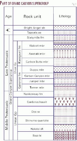
The Chuar Group contains good to excellent petroleum source rocks with up to 8% total organic carbon. Reservoir rocks have been identified in the Nankoweap formation, Walcott and Carbon Butte sandstone members, and Tapeats sandstone (Fig. 4).
Oil was reported east of Grand Canyon in the Collins Cobb 1X and southeast of Grand Canyon in the Lockhart 1 Babbitt. The oil in these two wells may have migrated from underlying Chuar Group source rocks.
Land is mostly forest and public north of Grand Canyon, Navajo Reservation to the east, and scattered tracts of state trust and fee to the southeast. Drilling depths range from 6,000 ft to 15,000 ft or more.
Paradox basin
The northeastern corner of Arizona includes the southernmost margin of the Paradox basin, most of which is in southeastern Utah.
Strata in northeastern Arizona grade laterally into southeastern Utah, where giant Aneth field has produced more than 415 million bbl of oil.
All current production in Arizona is from the Paradox basin. Oil and gas have been produced from strata of Paleozoic and Tertiary ages. Helium has been produced from Paleozoic rocks.
The potential for discovery in northeastern Arizona is considered to be good to very good. All land in this region is part of the Navajo Reservation. Drilling depths range from 2,500 ft to 6,000 ft.
Black Mesa basin
The Black Mesa basin contains marine to nonmarine rocks of Paleozoic and Mesozoic age. Cretaceous strata include extensive coal deposits.
Potential for oil and gas in Paleozoic strata of the Black Mesa basin is considered fair to good. Potential for coalbed methane in Cretaceous strata is considered very good to excellent. All land in the Black Mesa basin is Indian land. Drilling depths range from 500 ft to 6,000 ft.
Holbrook basin
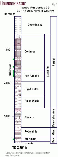
The Holbrook basin in east-central Arizona contains Paleozoic rocks including sabkha deposits of Permian age. The sabkha deposits consist principally of fine-grained red beds that are locally interbedded with limestone, anhydrite, and salt (Fig. 5).
The sabkha deposits in the Holbrook basin are similar in age and character to deposits in the Permian Basin of West Texas. Permian strata have hydrocarbon potential south of the Holbrook basin beneath the volcanic rocks of the White Mountains.
The potential for hydrocarbons and industrial gases in the Holbrook basin is considered good to very good. Evidence includes past production of helium, recent discovery of carbon dioxide, shows of oil and gas in numerous wells, and a seep and outcrops of petroliferous rocks along the southern edge of the basin.
Large blocks of state trust and fee land are present in the Holbrook basin. Drilling depths range from less than 4,000 ft to 6,000 ft.
Pedregosa and Bisbee basins
The Pedregosa and Bisbee basins in southeastern Arizona contain up to 25,000 ft of largely marine strata of Cambrian through Cretaceous age. The Bisbee basin of Cretaceous age generally overprints the older Pedregosa basin.
Paleozoic rocks and regional unconformities in the Pedregosa basin are similar in age and character to those in the Permian Basin of West Texas, where truncated strata beneath the regional unconformity form important hydrocarbon traps.
Lower Cretaceous marine rocks contain reefs similar to those that produce oil in Texas and Mexico. Upper Cretaceous rocks in Mexico about 15 miles south of Douglas contain coal seams that may yield coalbed methane in the vicinity of Douglas.
Evidence for hydrocarbons in the Pedregosa and Bisbee basins includes shows of oil and gas in wells, including 450 ft of oil-cut mud in one well, and petroliferous rocks. Color changes in conodonts show that the Paleozoic rocks in southeastern Arizona are within the oil and gas window.
Potential of the Pedregosa and Bisbee basins is considered fair to very good. Interstate pipelines cross the area and provide a market outlet. Large blocks of state trust and fee land are available. Drilling depths range from 4,000 ft to 15,000 ft or more. Drilling density is about one well/395 sq miles.
Yuma basin
The Yuma basin in southwestern Arizona is part of the Salton Trough and merges into the Altar basin in Mexico.
The Yuma basin contains a thick sequence of Tertiary deposits and may have been in proximity to the prolific Los Angeles Basin, which has been displaced northward along the San Andreas fault.
A well drilled by Petroleos Mexicanos SA in the Gulf of California produced up to 5.7 MMcfd of gas at a depth of 13,500 ft. The producing interval in the Pemex well may extend northward into the Yuma basin, where no wells are deep enough to have tested it.
The hydrocarbon potential of the Yuma basin is considered fair to good. State trust, fee, and public lands are available. Prospective land on the Barry M. Goldwater Aerial Gunnery Range is currently withheld from leasing and exploration. Drilling depths range from 4,000 ft to 20,000 ft or more.
Tertiary basins
At least 14 Tertiary basins, primarily in southern and southwestern Arizona, have not been adequately tested for hydrocarbons. These basins are filled with diversely stratified Tertiary deposits preserved in down-faulted blocks of the Basin and Range Province.
Some of the Tertiary basins contain thick evaporite deposits. Two of the basins contain a minimum of 10,000 ft of salt.
Organic-rich rocks of Paleozoic, Cretaceous, and Tertiary age could serve as hydrocarbon source rocks in the Tertiary basins. Oil produced from the Tertiary reservoirs in Nevada appears to have been derived from source rocks of Paleozoic and Tertiary age.
None of the deep Tertiary basins has been adequately tested. Very few deep wells have been drilled, and no wells have penetrated the thick evaporite deposits.
Potential of the Tertiary basins is considered to be good where deeply buried organic-rich strata are beneath the thick evaporite deposits. Most land is either fee or state trust. Drilling depths range from a few hundred feet to more than 12,500 ft.
The author
Steven L. Rauzi joined the Arizona Oil & Gas Conservation Commission in Phoenix in 1988. That agency was merged into the Arizona Geological Survey in 1991. He now serves as the oil and gas administrator for the survey in Tucson. He worked for Texaco in Los Angeles as an exploration and development geologist during 1980-87. His current interests include salt basins in Arizona. He received BS and MS degrees in geology from Utah State University. E-mail: [email protected]
