Guiana Shield tectonics influence hydrocarbon bearing compartments
Bernard Collet
Consultant
Paris, France
Yannis Bassias
HHRM Co.
Athens, Greece
Interpretations of magnetic anomolies, fracture-zone geometry, and continental-oceanic crust transitions frame the debate surrounding the tectonic opening of the Equatorial and South Atlantic Ocean. Misinterpretations of movement in this region lead to misalignments and misunderstanding of the depositional environments at the margins.
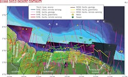
This article presents further evidence of the Guiana Shield's role during the initial separation between the American and African plates. Research suggests that the structure of the larger Guiana basin was controlled by the reactivation of Paleozoic and early Mesozoic faults, inherited from older orogenic belts. The same river paths fed the basin with clastic deposits for several tens to hundreds of millions of years. A network of NNW-SSE and NNE-SSW lineaments along the Atlantic margin coast and their onshore continuity at the edge of the Guiana Shield denote relics of deep faulting associated with the early rifting of the central Atlantic Ocean during early Jurassic, between 190 and 170 million years (Ma) (Fig. 1). These older faults were reactivated during Cretaceous E-W drift, a fact that created a favorable Tertiary-to-present structural and depositional environment for southward-shoreward hydrocarbon migration in the South American-Central Equatorial Atlantic margin (OGJ, Jan. 4, 2016, p. 42).1
Structure above crystalline basement
The Guiana Shield, between the Orinoco and the Amazon rivers, exposes a crystalline basement onshore formed with igneous and metamorphic rocks. To a lesser extent the basin is covered on the coastal plain by Upper Cretaceous to Holocene sediments with Pliocene to Holocene sediments cropping out at the surface (Fig. 1). Most of the basin lies offshore where the sedimentary pile is thicker and deeper. In contrast, the regional dip and thickness of the onshore sedimentary column is governed by the topography of the Precambrian basement.
The onshore sedimentary column thickens from south to north and at the center of the onshore part of the sedimentary basin. The column comprises Upper Cretaceous to Holocene sediments (part of the Corantijn Group). The Cretaceous section consists of continental deposits with evidence of several cycles of erosion. The Tertiary section comprises coastal to shallow marine deposits, while Quaternary sediments are mainly composed of sand and shale with minor shelly sands. Suriname's 17,000 bo/d production comes from continental to shallow marine reservoirs (Paleocene: Saramacca and Eocene and Miocene: Coesewijne) at depths of 350-800 m.2 As the coastal plain enlarges and deepens from French Guiana to Guyana the sedimentary thickness increases. There are no known indications for similar reservoirs onshore in Guyana or French Guiana.
Fault categories
Image interpretation identified three main structural compartments-A, B, and C from E-W-along the larger Guiana margin, both on and offshore (Fig. 1). The general N-S fault direction varies for each compartment: NNE-SSW in A, NNW-SSE in B, and again NNE-SSW in C. A second main fault direction, WSW-ENE, is common in all compartments and appears to parallel the southern border of the sedimentary blanket covering the shield. The slight changes of direction appear in conjunction with the coast line and the Conte and Appouague Rivers for compartments A and B, and with the Corantijn River for compartments B and C.
This research used Landsat, Shuttle Radar Topography Mission (SRTM) images, geological and geophysical maps of French Guiana, Suriname, and Guyana, and vertical gravity data from the offshore part of the basin.3-6 Further analysis used two types of satellite data: Landsat thematic mapper (TM) with a 30-m resolution and Digital Elevation Model SRTM3 from simple interferometry processing of radar data gathered by NASA's space shuttle. The images use red, green, and blue (RGB) composition of bands 7 (average infra-red), 4 (near infra-red), and 2 (green).
The zone of study is covered by vegetation, subordinating the choice of these three composition bands. The plants respond well to these bands' wavelengths, allowing effective differentiation between human activity and natural vegetation. Digital elevation model (DEM) SRTM has a 90-m resolution with 3 sec of angle and allows generation of slope and shadow images. DEM-shadowed image analysis occurs jointly with that of colored Landsat TM images to isolate objects resulting from human activity.
Our research calculated illumination for shadowed images with a 45° incidence angle and 45° N orientation. These parameters made it possible to illuminate the two families of lineaments. The modification of the DEM resolution amplified the image contrast and the variations of image roughness. This in turn helped define the objects' limits. Slope mapping determined the coherence between river flows and topography.
Offshore observations
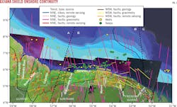
Gravimetry data from the basin show the presence of old lineaments, generally trending N-S (compartments A, B, and C), considered to be strike-slip faults related to an early rifting phase of Lower Jurassic age.1 These faults expand onshore and are visible on the crystalline basement (Fig. 1 and 2). They were reactivated during the late Jurassic-early Cretaceous when the W-E extension phase controlled the opening of the Atlantic Ocean, leading to extensional structures and creating space for tholeitic dikes (OGJ, Jan. 4, 2016, p. 42).1
Previous studies have questioned the presence of compartments in the deep offshore geometry and within the thickness of oceanic crust along the margin.7 At shallower depths, basement faults often observed in onshore and offshore seismic data terminate in the Eocene Upper Saramacca formation or in some cases in the Miocene Coesewijne formation. These fault terminations indicate that minor tectonic activity occurred during the drift phase from Late Cretaceous to Recent times along the margins of the Guiana Shield.2
Onshore observations
Surface analysis with satellite imagery helped locate the position of both fault categories, particularly under sedimentary cover. Image analysis in the crystalline basement, as in the sedimentary zone, highlighted two families of features (faults or fractures) with ENE-WSW, NNW-SSE, or NNE-SSW direction as observed offshore (Fig. 1). These directions are visible on a large scale by the rivers' flows, and at a smaller scale by radiometry variations in Landset TM, roughness of the shadowed images, and meanders' geometries.
The slope map shows that the sedimentary zone has an average angle close to 1° and can extend to 3° in some cases, compared to the horizontal plane (Fig. 2). Under these conditions, the rivers should flow perpendicular to the coastal line, sculpting important meanders. But each one of these rivers has a singular direction and geometry flowing in NNW-SSE or NNE-SSW parallel directions. Only Saramacca and Commewijne Rivers at the vicinty of Calcutta and Tambaredjo fields represent an exception, having an E-W direction (Fig. 2).
This change of direction is related to E-W trending faults. Recent 3D seismic studies combined with gravity and magnetic data from the Tambaredjo oilfield conclude that E-W (Tambaredjo fault) and the NE-SW (Broederschap fault) systems impact the local hydrocarbon entrapment.8
Regional tectonics
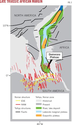
The NNW-SSE lineaments of Triassic-early Jurassic age are perpendicular to the WSW-ENE graben-rift system. Studies have suggested these systems represent an aborted rift that occurred before the change in plate motion from NNW-SSE to NW-SE between 190-170 Ma.2 This timing coincides with the North America-Africa separation. Studies have mapped the same NNW-SSE direction of Late Triassic (Norian) on the African margin at Senegal's latitudes (Fig. 3).9-11 While some tectonic reconstructions of the equatorial Atlantic have differences of 10 Ma, they all place the Demerara Plateau south of Dakar, Senegal, prior to the rifting of Africa from South America.
The Demerara Plateau, part of Compartment B in Fig. 1, is built on rifted continental crust of Paleozoic and early Mesozoic age. Barremian basaltic volcanics have been recovered in petroleum exploration wells from the Demerara Plateau, suggesting that NW-SE rifting began in the early Cretaceous. Indeed Barremian-Aptian shales were piston-cored while Jurassic sandstones were dredged at the northeastern part of the Plateau.12
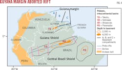
The second main direction, WSW-ENE, is parallel to the Palaeozoic intracontinental Amazonas and Solimoes basins filled dominantly with sandy Cretaceous to recent sediments. These basins have Jurassic to Cretaceous right lateral wrenching with short lateral or transcurrent movements and are considered an aborted rift (Fig. 4).13 14
Guiana Shield makeup
The two perpendicular fault directions, trending N-S and WSW-ENE, are the record of old tectonic deformations that affected what today is the edge of the Guiana Shield onshore, the African margin, and Florida. They were reactivated during late Jurassic-early Cretaceous and controlled the deposition of sediments from the rivers to the sea, many of which became source rocks and potential reservoirs. This fault system should advantage the southwards oil migration from the kitchen towards the continent as shown by the distribution of sea surface seepages. The suggested presence of compartments follows the geometry of the margin and may be related to differences in the thickness of the oceanic crust along the margin.
References
1. Bassias, Y., and Collet, B., "Hydrocarbon Migration Constraints in the South American Central Equatorial Atlantic Margin," American Association of Petroleum Geologists (AAPG) Prospect and Property Expo (APPEX) poster session, London, Mar. 3-5, 2015.
2. Staatsolie, "The Suriname-Guyana Basin: The Next Giant," Suriname 2013 International Bidding Round, AAPG International Conference and Exhibition, Singapore, Sept. 16-19, 2012.
3. Delor, C., Lahondere. D., Egal, E., Lafon, J.M., Cocherie, A., Guerrot, C., Rossi, P., Truffert, C., Theveniaut, H., Phillips, D., and de Avelar, V.G., "Transamazonian crustal growth and reworking as revealed by the 1:500,000-scale geological map of French Guiana (2nd edition)," Geologie de la France, 2003.
4. "Geological Map of Suriname at 1:500 000 scale," Geologisch Minsbouwkundige Dienst, Amsterdam, 1977.
5. Veldkamp, J., "Gravity Surveys in Surinam and the Netherlands Leeward islands area, 1958-1965," Netherlands Geodetic Commission, Publication of Geodesy, Vol. 3, No. 3, 1969, pp. 1-77.
6. Sandwell, D.T., "Satellite Geodesy," Scripps Institution of Oceanography, University of California, San Diego, topex.ucsd.edu.
7. Greenroyd, C.J., Peirce, C., Rodger, M., Watts, A.B., and Hobbs, R.W., "Demerara Plateau - the structure and evolution of a transform passive margin," Geophysical Journal International, Nov. 29, 2007, p. 172, pp. 549-564.
8. Griffith, C., and Bihariesingh-Raghoenath, V., "Petroleum: A New Economic Boost for Suriname," GeoExpro, Vol. 10, No. 4, September 2013, pp. 22-27.
9. Chubert, G., Faure-Muret, A., and Sougy, J., "Carte Tectonique internationale de l'Afrique," Association of African Geological Surveys and United Nations Educational, Scientific, and Cultural Organization, 1968.
10. Dercourt, J., Guetani, M., Vrielynk, B. "Atlas Peri-Tethys: Paleogeographical Maps and Explanatory Notes," Commission de la carte geologique du monde, 2000.
11. Labais, C., Olivet, J.L., Aslanian, D., and Roest, W., "An alternative early opening scenario for the Central Atlantic Ocean," Earth and Planetary Science Letters, Vol. 297, No. 3-4, Sept. 1, 2010, pp. 355-368.
12. Fox, P.J., Schreiber, E., and Peterson, J., "Compressional wave velocities in basalt and altered basalt recovered during Leg 14," Initial Reports of the Deep Sea Drilling Project, Vol. LIX, 1972, pp. 773-776.
13. Milani, E.J., and Zalan, P.V., "An outline of the geology and petroleum systems of the Paleozoic interior basins of South America," Episodes, Vol. 22, No. 3, September 1999, pp. 199-205.
14. Caputo, M.V, and Silva, O.B., "Sedimentation and Tectonics in the Solimoes Basin," Origin and Evolution of Sedimentary Basins, Petrobras, Rio de Janeiro, 1999, pp. 169-193.
The authors
Bernard Collet ([email protected]) is a consultant geologist. He served on the oil and gas regulatory team of the French Ministry of Ecology and Energy from 2013 to 2017 where he covered the technical evaluation of exploration matters for France and overseas French territories. He has worked with university and industry clients in East and North Africa, Venezuela, and eastern Turkey. He holds a PhD (1998) from the University Pierre et Marie Curie in Paris.
Yannis Bassias ([email protected]) is president and CEO of the Hellenic Hydrocarbon Resources Management Co., the regulator for oil and gas exploration and production in Greece. He also served as president and CEO of Georex from 1997 to 2012 and president of Poros SAS between 2007 and 2012, overseeing exploration assets in the Paris basin and Tunisia. He held academic positions in Berlin and Paris before joining the industry in 1991. He holds a PhD (1984) from the University Pierre et Marie Curie in Paris.


