Columbia River basin wildcat to draw focus to Washington
Renewed exploration for deep gas is under way in Washington state more than 15 years after the end of the previous cycle.
EnCana Corp., Calgary, drilled the surface hole in January 2005 at the 1 Anderville Farms well in Grant County 35 miles east-northeast of Yakima (OGJ Online, Jan. 28, 2005).
EnCana, flush with drilling, stimulation, and completion expertise in low-permeability formations and basin-centered gas plays in Rocky Mountain basins in the US and Canada, drilled to 1,550 ft, ran 20-in. conductor casing, and suspended the well. It is to be deepened later to circa 14,000 ft using suitable rigs.
The company is said to be returning to the Columbia River basin with modern technology to tap gas that couldn’t be produced economically with the knowhow available in the last exploration cycle in the 1970s-1980s.
EnCana’s foray
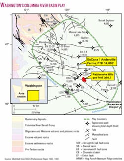
Site of the current drilling is 35 miles east-northeast of Yakima and north of the US Department of Energy’s Hanford nuclear reservation (see map).
The well, in 6-14n-25e, Grant County, is waiting for a rig that is being specially built in Salt Lake City to drill basaltic lavas. Expected at the drillsite in May, this rotary could be expected to penetrate 8,000-10,000 ft of basalt.
Later a conventional rig would be moved in to drill the subbasalt nonmarine sedimentary strata to as deep as 14,000 ft. One source said that present information indicates the well is being drilled as a basin-centered gas test.
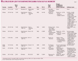
EnCana’s drill site is a few miles south of the Shell Western E&P Inc. 1 BN, drilled to TD 17,518 ft in the Eocene Roslyn formation in 1984-85 and still the state’s deepest hole (see table). That well recovered gas at noncommercial rates from 12,000-13,000 ft, below almost 2 miles of Miocene basalt.
Shell also tested gas at the 1-33 Yakima Minerals well.
Rattlesnake Hills gas field, the only accumulation to have produced in the basin, was discovered during the drilling of a water well in 1913. It was developed around 1930 and abandoned in 1941 after having produced an estimated 1.3 bcf of gas.
The field’s gas was trapped in a faulted anticline between two vesicular zones in basalt flows sealed by clay interbeds, at 700-1,300 ft.
Columbia River basin
The Columbia River basin in Washington and Oregon is one of the largest nonproductive basins in the US.
US Geological Survey Professional Paper 1582 refers to a hypothetical gas play (501) in the northwestern Columbia Plateau.
“The thickness of the prospective section ranges from about 4,000 ft to 20,000 ft (1,219 to 6,096 m) or more, based on thicknesses of exposed sequences at the northwest margin of the play,” wrote Samuel Y. Johnson and three other scientists. They sized the play at 125 miles long and 60 miles wide.
“Potential reservoirs are Eocene or Oligocene arkosic fluvial sandstone beds of the nonmarine Swauk, Chumstick, Roslyn, Manastash, and Wenatchee formations and coeval units. These units are all exposed on the northern and western margins of the play, where they are interbedded with substantial thicknesses of volcanic rocks,” the USGS report said.
Potential source rocks are lacustrine and fluvial shales in the Swauk and Chumstick formations and coal beds in the Roslyn formation, the paper said.
The authors also described a basin-centered gas play (503) that covers about the same play area as Play 501 but said the areal and spatial extent of the 503 accumulation are imprecisely known because of insufficient deep drilling. This is the play EnCana is believed to be pursuing, and the USGS assessed its mean undiscovered technically recoverable resource at 12.2 tcf in the 1997 paper.
Potential basin-centered reservoirs “consist of Eocene arkosic fluvial sandstone bodies that are exposed on the northern margin of the play and consist of the Swauk, Chumstick, Roslyn, and Manastash formations,” the USGS report said.
The report mentioned porosities of 6-15% calculated from logs and said the gas-bearing interval is at least 6,400 ft thick. Maximum thickness is not known because no well has entirely penetrated the interval. Depth of reservoirs appeared to range from 8,300 ft to more than 17,000 ft. ✦


