P. 4 ~ Continued - Methane in Pennsylvania water wells unrelated to Marcellus shale fracturing

Displaying 4/10
View Article as Single page
3. Middle Devonian.
Tully limestone.
The Tully limestone, a fossiliferous calcareous shale, underlies the Lock Haven formation.
Hamilton Group (Mahantango formation and Marcellus shale).
Middle Devonian formations of the Hamilton Group can be found beneath the Tully limestone. These include the Mahantango formation, consisting of laminated shale, siltstone, sandstone, and claystone, and the carbonaceous Marcellus shale, which is located at the base of the Hamilton Group.
The Marcellus shale is currently the target of shale gas extraction throughout the Appalachian basin and has been estimated to contain as much as 84 tcf of gas.18 The Upper Devonian Catskill and Lock Haven formations have also been historically explored and drilled for oil and gas, although these shallow gas zones are not presently considered economical.
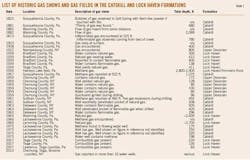
Table 1 summarizes numerous published records of gas shows in water and oil wells drilled into the Catskill and Lock Haven formations in Susquehanna County and surrounding areas over the past 200 years. For example, an oil boring described in an 1881 publication was reported to have encountered substantial amounts of gas while drilling to a depth of 680 ft within the Catskill formation.20
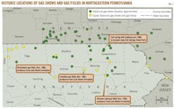
In addition, the Pennsylvania Geological Survey's 1922 publication "The Oil and Gas Fields of Pennsylvania" describes several instances of known shallow hydrocarbon production less than 2,100 ft beneath the surface in the Catskill formation in Wyoming County, directly to the south of Susquehanna County.21 Numerous other instances of methane gas encountered at depths ranging from 80 to 800 ft below grade in the Catskill or Lock Haven, dating to recent years, are indicated on Table 1 and Fig. 3.
Geologic studies suggest that, during deep burial of the Upper Devonian 270 million to 290 million years ago,22 oil within the organic rich strata of the Catskill and Lockhaven formations was cracked to gas. This gas was subsequently expelled and accumulated in overlying and adjacent sandstone stratum within the same formations.22
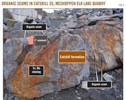
This finding is supported by the observation of numerous lenses of organic material in sandstone (bluestone) quarries and outcrops in Susquehanna County (Fig. 4). These organic seams have a measured vitrinite reflectance of 2.02, within the range sufficient to produce dry gas from organic material.23
A systematic and consistent fracture (i.e., joint) network is also observed in Upper Devonian bedrock exposures throughout the region.15 The locations of valleys and draws are commonly observed to be controlled by these fractures and joints.15 Vertical fracture planes are primarily oriented north-south, with penetrative planar fractures cutting through both the sandstone and shale beds of the Catskill formation.24 Inferior fracture sets are oriented west-east, northeast-southwest, and northwest-southeast, and stress relief fractures and bedding plane partings are also developed in the area.13 Iron staining and other mineral precipitation is abundant along the north-south oriented fracture surfaces, serving as evidence of ground water flow via the fracture planes.
The LiDAR map shows various linear trends that are often related to near-surface fracturing, faulting, and glacial erosion patterns. Some surface drainages are observed to closely follow these lineations, such as Wyalusing Creek, a tributary of the Susquehanna River, which exhibits orthogonal drainage patterns that exemplify the relationship of surface drainages and regional geomorphology to existing fracture networks and surface fold trends.
Displaying 4/10
View Article as Single page