P. 3 ~ Continued - Methane in Pennsylvania water wells unrelated to Marcellus shale fracturing
Displaying 3/10
View Article as Single page
Geologic conditions in Susquehanna County
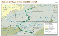
Understanding the geologic and hydrogeologic context of Susquehanna County is important for determining the source of elevated methane gas concentrations observed in lowland water wells (Figs. 2a and 2b).

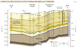
Susquehanna County is in the northeastern Appalachian basin, an area characterized by Paleozoic sedimentary rocks including organic-rich shales, siltstones, sandstones, and carbonates deposited in marine and fluvial environments.
These formations frequently contain "thermogenic gas," which formed from the burial of entrained organic material at sufficient temperatures and pressures within the earth to generate hydrocarbons abiotically. These thermogenic sources are distinct from "biogenic" methane, which forms from the biodegradation of organic material in the shallow subsurface, such as in alluvial and glacial drift deposits.
Most of the sedimentary shale deposits currently being developed for shale gas in the Appalachian basin formed during the Devonian period, subdivided by age into the Upper Devonian (359 million to 385 million years ago), Middle Devonian (385 million to 398 million years ago), and Lower Devonian (398 million to 416 million years ago) epochs.6 The characteristics of the principal geologic strata, and associated groundwater resources, beneath Susquehanna County are as follows, in order of increasing depth:
1. Quaternary.
Glacial drift and alluvium.
Surface geology is dominated by deposits of glacial drift (glacial till and outwash) and Quaternary alluvium, including sands, silts, clays, peat, and gravel.7-10
These deposits typically range from tens of meters thickness in valleys and drainages to a few meters on mountain tops.11 A limited number of water wells are completed in this stratum; however, drilling logs show that most water wells extend into the underlying sandstone bedrock.12
2. Upper Devonian.
Catskill formation.
The Catskill formation, consisting of sandstone, shale, siltstone and conglomerate, underlies the surficial deposits. The Catskill formation outcrops on ridgetops in the majority of Susquehanna County (with the exception of the northern and northwestern portions of the county), and is roughly 1,800 ft thick.9 The Catskill contains numerous sandstone beds that are water-bearing and is the primary aquifer accessed by local water wells, which are usually completed through glacial drift and alluvium into the unconfined aquifers of the Catskill formation at typical depths of 200 to 400 ft.12-15
In Susquehanna County, groundwater flow in the Catskill sandstone is primarily controlled by fracture flow through secondary porosity,16 with overall regional groundwater flow moving from north to south.17 Most water wells completed in the Catskill formation contain casing with only limited grouting, and are unsealed so as to draw groundwater from multiple water-bearing horizons and-or fractures.12
Lock Haven formation.
The Catskill formation is underlain by the Lock Haven (formerly Chemung) formation, comprised of interbedded units of sandstone, siltstone, and shale. The Lock Haven formation outcrops in the northwest and northern parts of the county and has been shown to contain brackish water.13 15
The Bradford sands, a locally known subdivision of the lower Lock Haven formation, is comprised of abundant sandstone deposits.
Brallier (Elk) formation.
Upper Devonian subsurface units beneath the Lock Haven include the Brallier, locally known as the Elk formation, and the Trimmers Rock formation in northeastern Pennsylvania.18 The Brallier and Trimmers Rock formations are comprised principally of interbedded sandstone, siltstone and shale.
Displaying 3/10
View Article as Single page