P .2 ~ Continued - Pilot shale awaits oil exploration in Great Basin

View Article as Single page
Gravity, other subsurface data
Structural models, and gravity data calibrated with well data, are used to identify depth of the buried Pilot shale.
Commercially available gravity data are available as disparate gravity surveys of varying vintages and quality mostly concentrated in the valleys. A consistent, state-of-the-art gravity survey in the ranges between the valleys acquired by the authors constitutes the most extensive proprietary Great Basin gravity survey.
The existing commercially available gravity data are greatly improved when merged with the new survey of nearly 20,000 highly accurate, modern proprietary terrain-corrected gravity stations.
When coupled with commercially available magnetic data and the new geologic map, the gravity merge provides cross cutting relationships that reveals the tectonic history of the Great Basin. For example, the gravity merge shows that Diamond (Eureka County) and Railroad (Nye County) valleys are structural lows filled with low-density Tertiary valley fill including Oligocene lava flows.
The high magnetic susceptible lava flows are expressed as magnetic highs within the valleys. Therefore, in contrast to conventional wisdom suggesting that these valleys are a result of recent extensional phase, the valleys were likely formed as a result of tectonic compression tens of millions of years earlier.
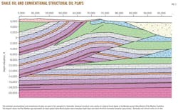
The authors are now engaged in creating restorable balanced structural cross sections (Fig. 5) constrained with the new surface mapping, more than 200 well studies (entire Great Basin), regional structural style, and gravity and seismic data. These structural models are also confirmed by comparing the calculated gravity profiles with the observed gravity profiles.
Modern structural modeling software facilitates thrust fault restoration to see if the restored thrust sheets make depositional sense. When fully restored, the Pilot shale subbasin has dimensions similar to those of the Williston basin. The stacked thrust sheets allow for multiple pay zones at a single location.
The authors
Alan K. Chamberlain ([email protected]) was employed with Exxon, Gulf, Marathon, and Placid oil companies before starting Cedar Strat Corp. in 1984. He has been conducting the Great Basin geological survey ever since. He has a BS and MS in geology from Brigham Young University and a PhD in geology from Colorado School of Mines.
S.K. Bhattacharjee (Kumar) is co-owner of Sita Oil Exploration House Inc., Houston ([email protected]). He has worked as an explorationist in national oil companies including Sonatrach, in large independents including Union Texas Petroleum and Maxus Energy, and small independents such as Frontera Resources. He has worked on projects funded by the US Department of Energy and US Agency for International Development. A 40+ year industry veteran, he has a BS in geology, an MS in geophysics, and has done postgraduate study in applied geophysics.
Displaying 2/2
View Article as Single page
More Oil & Gas Journal Archives Issue Articles
View Oil and Gas Articles on PennEnergy.com