Pilot shale awaits oil exploration in Great Basin
Alan Chamberlain
Cedar Strat Corp.
Las Vegas
S.K. Bhattacharjee
Sita Oil Exploration
Houston
The organic rich, thermally mature, oil-prospective Pilot shale, age equivalent of the Bakken formation in the Williston basin, underlies a large part of the eastern Great Basin in Nevada and Utah.
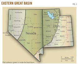
An isopach map constructed by the authors indicates that the Pilot shale is at least 140 ft thick under 45 million acres of the 71 million acres of the eastern Great Basin (Fig. 1). Moreover, the Pilot shale is at least twice as thick as the Bakken under 17.2 million acres and 800 ft thick or more under 1.3 million acres.
Integration of extensive surface mapping, measured sections, well studies, and recent gravity data acquisition suggests that these shales are stacked in laterally extensive and coherent thrust sheets at relatively shallow (~7,000 ft) to relatively deep (18,000 ft) depths.
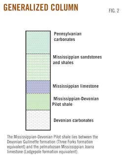
Both the Pilot and the Bakken lie between Devonian and Mississippian carbonates (Fig. 2).
Proprietary geological survey
Though the Great Basin, with its sparse and sporadic exploration history, has had commercial oil production since the 1950s, federal and state agencies have made no effort to conduct a systematic and accurate geological survey.
At the request of several major oil companies, a privately funded proprietary geological survey has been under way for 3 decades to fill the exploration gap.
The proprietary geological survey began by improving and expanding the Great Basin stratigraphic framework of one of the major oil companies in order to identify mappable stratigraphic sequences and collect samples for source, reservoir, and biostratigraphic analyses.
Compiling publicly available geologic maps into a single map and then correcting and improving the map with more than 55,000 precisely located structural attitudes and lithologic descriptions allows for the creation of an accurate master geologic map of these mappable stratigraphic sequences.
The stratigraphic framework and new geologic map provides the foundation for structural and basin modeling that provide exploration leads and the basis for appraising prospects.
Oil-prone Pilot shale
The new Great Basin geological survey indicates that the Pilot shale occurs at relatively shallow depths in extensive, lateral cohesive thrust sheets.
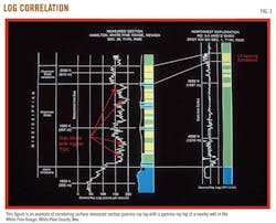
Measured sections with surface gamma ray logs greatly supplement the paucity of the approximately 20 wells that have penetrated the Pilot shale and helps reduce confusing stratigraphic nomenclature of the region (Fig. 3). Also, surface gamma-ray logs combined with lithologic descriptions help identify stratigraphic sequences that can then be correlated between thrust sheets (Fig. 4).

Colorado River drainage basin headward erosion exposes the Cordillera thrust belt in the Timpahute Range, Lincoln County, Nev., about 100 miles north of Las Vegas. Correlation of exposed Devonian sequences between thrust sheets facilitates structural modeling and thrust fault restoration.
Combining measured section data with well data provides a clear understanding of lateral distribution of exploration targets in this promising and yet unexplored subbasin.
The authors combined conodont analysis with palynomorph analyses of thousands of outcrop samples and well cuttings to obtain accurate information on age, maturity, depositional environment, kerogen type, and richness of the shales. These fossil data indicate that the marine Pilot shales are oil-prone, thermally mature, and organically rich in contrast with the gas prone overlying Mississippian Chainman shales containing terrestrial plant bearing regressive sequences. Descriptions of measured sections and outcrop samples show that the Pilot has better or at least similar potential reservoir lithofacies as the Bakken. The argillaceous siltstone to very fine-grained sandstone lithofacies in the middle Pilot shale offers an attractive potential reservoir target.
The surface gamma-ray log, a field technique pioneered by the authors, allows identification of strata with the highest organic content. X-ray fluorescence (XRF) analysis of surface samples and cuttings provides another tool for correlating surface and subsurface sections and correlation between source shales and oil.
For example, oil from Blackburn field in Pine Valley contains elevated concentrations of vanadium. XRF analyses of Pilot shale samples from the adjacent Pinon Range and from the Fish Creek Range, on strike to the south, also show elevated concentrations of vanadium.
Gravity, other subsurface data
Structural models, and gravity data calibrated with well data, are used to identify depth of the buried Pilot shale.
Commercially available gravity data are available as disparate gravity surveys of varying vintages and quality mostly concentrated in the valleys. A consistent, state-of-the-art gravity survey in the ranges between the valleys acquired by the authors constitutes the most extensive proprietary Great Basin gravity survey.
The existing commercially available gravity data are greatly improved when merged with the new survey of nearly 20,000 highly accurate, modern proprietary terrain-corrected gravity stations.
When coupled with commercially available magnetic data and the new geologic map, the gravity merge provides cross cutting relationships that reveals the tectonic history of the Great Basin. For example, the gravity merge shows that Diamond (Eureka County) and Railroad (Nye County) valleys are structural lows filled with low-density Tertiary valley fill including Oligocene lava flows.
The high magnetic susceptible lava flows are expressed as magnetic highs within the valleys. Therefore, in contrast to conventional wisdom suggesting that these valleys are a result of recent extensional phase, the valleys were likely formed as a result of tectonic compression tens of millions of years earlier.
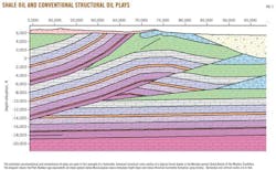
The authors are now engaged in creating restorable balanced structural cross sections (Fig. 5) constrained with the new surface mapping, more than 200 well studies (entire Great Basin), regional structural style, and gravity and seismic data. These structural models are also confirmed by comparing the calculated gravity profiles with the observed gravity profiles.
Modern structural modeling software facilitates thrust fault restoration to see if the restored thrust sheets make depositional sense. When fully restored, the Pilot shale subbasin has dimensions similar to those of the Williston basin. The stacked thrust sheets allow for multiple pay zones at a single location.
The authors
Alan K. Chamberlain ([email protected]) was employed with Exxon, Gulf, Marathon, and Placid oil companies before starting Cedar Strat Corp. in 1984. He has been conducting the Great Basin geological survey ever since. He has a BS and MS in geology from Brigham Young University and a PhD in geology from Colorado School of Mines.
S.K. Bhattacharjee (Kumar) is co-owner of Sita Oil Exploration House Inc., Houston ([email protected]). He has worked as an explorationist in national oil companies including Sonatrach, in large independents including Union Texas Petroleum and Maxus Energy, and small independents such as Frontera Resources. He has worked on projects funded by the US Department of Energy and US Agency for International Development. A 40+ year industry veteran, he has a BS in geology, an MS in geophysics, and has done postgraduate study in applied geophysics.
More Oil & Gas Journal Current Issue Articles
More Oil & Gas Journal Archives Issue Articles
View Oil and Gas Articles on PennEnergy.com