BURGOS TARGETS—1: Burgos basin play analysis reveals Frio-Vicksburg exploration focus areas
A recent Pemex study of the Burgos basin indicated considerable exploration potential and reserves growth opportunities from field rehabilitation in Mexico.
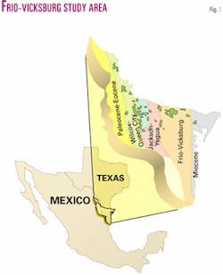
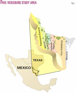
Pemex conducted a detailed analysis of the Burgos basin's Frio-Vicksburg play to identify future exploration focus areas. The Frio-Vicksburg play is one of five Tertiary producing trends, which include from west to east: the Paleocene-Eocene, Wilcox-Queen City, Jackson-Yegua, Frio-Vicksburg, and Miocene (Figs. 1 and 2).
The Frio-Vicksburg and Wilcox-Queen City plays together produce 97% of the gas in the Burgos basin. The Frio-Vicksburg alone has produced more than 4.1 tcf.
This study involved the regional mapping of major structural elements, definition of the Frio-Vicksburg stratigraphic framework, mapping of depositional systems, reservoir sands, well performance and show data, and integration and comparison with the Frio-Vicksburg in South Texas.
Fifty-two subplays were identified within 13 stratigraphic units across the study area, which were recombined into six plays to aid in comparison with South Texas producing analogs. Plays were then ranked and stacked to identify future focus areas.
Burgos basin gas production was established in the late 1940s in the Mision field, and by 1970 had peaked at 620 MMcfd. By early 1994, production had declined to 183 MMcfd. With demand for gas increasing in northern Mexico, Pemex embarked on an ambitious exploration and development program to reverse the decline and by 1997 had increased the production to 1 bcfd, which remains the case today.
With the planned offering of several blocks to multiservice contractors, Pemex forecasts production to increase to 2 bcfd within 4 years.
Structural setting
An interpretation of the regional structural configuration of the Frio-Vicksburg section across the Burgos basin was generated from a coarse 2D seismic grid and 450 wells.
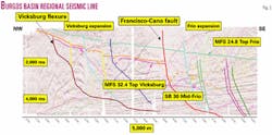
Three regional seismic markers corresponding to top Frio (MFS 24.8 toward base of Anahuac shale), middle Frio (SB 30) and top Vicksburg (MFS 32.4) were identified and correlated across the basin and northward into Texas Railroad Commission Dist. 4 (RRD4). The markers were used for regional structure mapping, to provide a basis for resolving nomenclature differences between areas, and in correlating and extrapolating tectonic elements (Fig. 3).
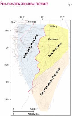
Faults strike generally north-south across the Burgos basin and can be readily traced north into Texas RRD4. The dominant north-south Vicksburg and Frio fault trends are supplemented by a secondary northeast-southwest trend that parallels the large San Fernando fault. Three structural provinces are recognized across the study area (Fig. 4).
In the northwestern part of the Burgos basin Vicksburg expansion dominates the first province. Significant basinward, lateral movement occurred along the Vicksburg detachment system, which glides on or within the Eocene Jackson shale. Accommodation space was created at the head of the detachment system as older section continually translated down dip along the detachment surface.
In the second province the Frio Francisco-Cano fault system separates expanded Vicksburg section from expanded Frio section. Through the complex interplay of accommodation and sediment supply the Frio progrades basinward and initiates younger faulting to the east. At the far eastern edge of the study area major Miocene expanded sediments overlie the Frio.
The third province is distinguished by a northeast-southwest trending normal fault system that extends across the entire southern half of the study area. This trend may be related to forces active in the fold and thrust belt to the west that manifest themselves as lineaments recognized on satellite and aerial images.1 The northeast-southwest faults begin just south of Monterrey field, becoming the dominant structural trend south of the San Fernando fault.
The top of the Frio formation is relatively unstructured in the Burgos basin and displays a north-south structural grain and gentle east dip. Western faults have relatively small throws, on the order of 30-100 m. Fault throws are larger along eastern faults, which display Upper Frio and Lower Miocene expansion. The upper Frio outcrops at the western edge of the study area and reaches depths of more than 3,500 m in the east.
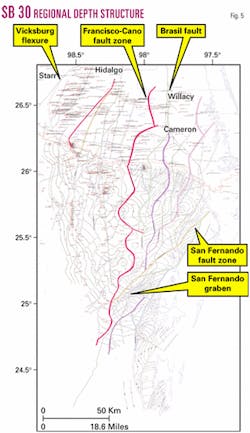
Significantly more structural relief exists at SB 30 level (Fig. 5), particularly east of the Francisco-Cano expansion fault. Overall, SB 30 structure reveals the basin depocenter to be north of the Rio Grande with significant Frio expansion occurring eastward of the Francisco Cano fault.
Middle Frio sediments outcrop in the west and reach greater than 5,000 m in the east. At SB 30 level a significant number of high-side and low-side fault-dependent and fault-independent traps are evident ranging in depth from 1,400 m to 4,000 m. In the south, expansion on the order of 2,500 m with sediment sourcing from the southwest, is found within the San Fernando graben. Here, as-yet untapped combination structure-stratigraphic trapping is anticipated in the Upper Frio.
The deepest mapped interval, the top Vicksburg (MFS 32.4) outcrops to the west and attains depths in excess of 5,000 m in the east. Again, the overall structural configuration indicates a basin depocenter north of the Rio Grande. Very few Vicksburg penetrations exist east of the Francisco Cano fault zone. As with the lower Frio, traps include high-side and low-side fault dependent structures, fault-independent structures, and combination structural-stratigraphic traps within the San Fernando graben system.
A second graben system, recognized on seismic data, lies beneath the mapped MFS 32.4 horizon south of the Cuitlahuac field and contains in excess of 2,000 milliseconds of pre-Miocene sediment, deposited directly onto the Cretaceous. Combination structural-stratigraphic traps may be anticipated although at depths greater than 3,000 m.
Stratigraphic framework
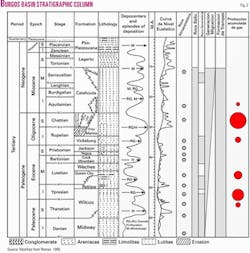
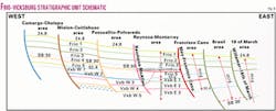
A sequence stratigraphic framework was defined which recognizes five Frio and eight Vicksburg stratigraphic units (Fig. 6). All five Frio units, located between the MFS 24.8 and the MFS 32.4, were correlated and mapped across the study area.
Correlation of the Vicksburg stratigraphic units is made difficult by significant section expansion across major growth faults and sliding on the unstable muds of the underlying Jackson group. While the uppermost Vicksburg marker, MFS 32.4, can be correlated across the study area, older flooding surface markers are correlated within, but not across, the three fault-bounded, structurally defined provinces.
Systems mapping
Depositional systems tract analysis is an ideal technique for predicting, with a high degree of reliability, the potential distribution of reservoir facies in areas of sparse well data.
After the stratigraphic framework was established, a set of lithofacies maps defining the depositional systems and sediment dispersal patterns was constructed. For each of the stratigraphic units, a suite of maps was generated that included gross sandstone thickness, log facies, net sand-porosity (phi-h) thickness, and production-hydrocarbon show maps.
Combining the information from these maps and modern analogs allowed a paleographic interpretation to be made and a reconstruction of depositional system morphology. Integrating this suite with structure maps and incorporating exploration and production model concepts developed from Burgos producing fields and Texas analogs allowed the potential of the Frio-Vicksburg to be defined.
Depositional architecture mapping has identified major depositional systems that include bedload and coastal streamplain systems, fluvial and wave-reworked delta systems, strandplain and barrier lagoon systems, interdeltaic embayments, and shelf and slope systems.
For the Frio or Vicksburg, no one depositional system can be identified uniquely as having either the highest quality or lowest quality reservoir and potential. The barrier-lagoon and wave-reworked delta systems account for the majority of the production primarily because they are the most common systems.
The main sediment source is from the northwest, and the majority of the Burgos basin sediments are from the ancient Rio Bravo delta. In addition to this, a second sediment province was identified in the southwest part of the basin where sediments are interpreted to be responsible for sourcing the San Fernando delta.2
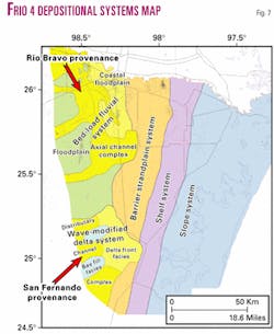
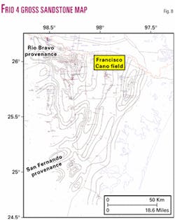
For illustration, depositional architecture maps for the Frio 4 stratigraphic unit are presented, including a display of the depositional systems interpreted from log facies character and sand body geometries resulting from gross sandstone mapping (Fig. 7). Five major depositional systems are interpreted in the Frio 4:
- A large barrier-strandplain system extends southward from the Texas border to the southern part of the Burgos basin.
- Shelf and slope depositional systems lie seaward of the barrier-strandplain system.
- The Rio Bravo fluvial and coastal-plain systems lie landward of the barrier-strandplain system.
- The San Fernando wave-modified delta system that prograded northeasterly from the southwestern corner of the Burgos basin.
Syndepositional growth faulting was very active during Frio 4 deposition and strongly influenced sandstone distribution and facies architecture. In the west, Frio 4 fluvial systems contain dip-oriented sand-rich axes that thicken and merge forming a pattern that defines the major channel axes.
Broad sand-poor areas interpreted as west-to-east aggradational floodplain facies separate the channel axes (Fig. 8). Eastward sand body geometry changes markedly to a north-south strike-oriented sand-rich barrier-strandplain depositional system.
One example can be found extending southward from Francisco Cano field. Coastal plain facies occupy the area between the fluvial and barrier-strandplain systems. The sequence is greatly expanded across syndepositional growth faults east of the barrier-strand-plain system, and the gross interval here is shore parallel and shalier but contains thick gross sandstones. These more shale-rich sequences occurred in shelf and slope depositional systems.
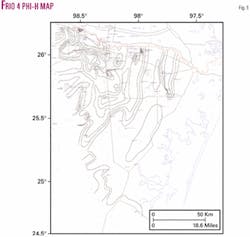
The Frio 4 phi-h map (porosity * net sand thickness) in Fig. 9 displays excellent reservoir potential over the northwestern two-thirds of the basin, while in the southeast and easternmost parts reservoir quality deteriorates. Porosities are highest in the fluvial and barrier-strandplain systems in the west and diminish to the east as the barrier system passes into the shelf and slope. Data are insufficient in the southern part of the basin to assess the reservoir potential.
Next: Play analyses and comparisons with South Texas.
