Coalbed gas play emerges in eastern Kansas basins
The Cherokee and Forest City basins in eastern Kansas and western Missouri, which comprise part of the Western region of the Interior Coal Province, are venerable energy-producing basins (Fig. 1). Coalbed gas represents a new potential resource that could revitalize this region.
Higher gas prices, increasing demand for natural gas, and new technologies have turned coalbed gas into an active energy play. Coalbed gas represents approximately 7% of total dry gas production and 9% of dry-gas proved reserves of the US.1 2 These values are expected to increase in the future.
In the last two decades, the total coalbed methane gas production in the US is in excess of 7 tcf, a value of $156.1 billion, at a price of $2.23/Mcf.3
Brief history
The history of petroleum production in eastern Kansas started over a century ago.
In 1860, as soon as one year after Col. Drake's historic well first produced oil near Titusville, Pa., drilling for petroleum reportedly commenced near the town of Paola, in eastern Kansas.4 Oil and gas production started in the late 1800s and most of the larger fields were discovered and delineated by 1930.
Conventional petroleum production continues to the present, but it has been in decline for several decades. Virtually all of it is now stripper production.
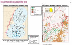
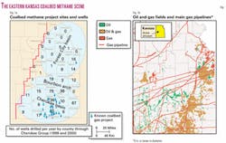
Most drilling activity for both conventional reserves and coalbed gas is in the Cherokee basin and Bourbon arch (Fig. 1A), with considerably less activity in the Forest City basin.
Coals also have been produced from surface and subsurface mines in eastern Kansas since the mid-1800s. Peak production was during World War I and production from only strip mines continues to present time, but these operations are very small and are carried out by only local companies. Surface and subsurface mines have produced over 300 million tons of coal in Kansas.5
Coalbed gas production began in Kansas in the mid-1980s. No systematic compilation of coalbed gas fields in Kansas exists, but a regional map is presented (Fig. 1A). At least 232 wells were completed for coalbed gas in Kansas by 1993,6 and total completions have more than doubled since then, with a virtual explosion in drilling in 2001 and 2002 (Table 1). The Cherokee basin in the southeastern part of the state hosts the majority of these wells.
Present resource
Coal beds in eastern Kansas tend to be widely distributed, but the primary concerns are their thinness and their correspondingly smaller volumes of gas.
Evaluation of 600 geophysical logs from eastern Kansas indicates that 85% of the coal occurs in beds 14-28 in. thick, 11% occurs in beds 28-42 in. thick, and 4% occurs in beds thicker than 42 in.7 The main strategy for exploring for coalbed gas will thus be to locate thicker coals or multiple coal beds.
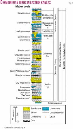
Thirty-two coal beds, with thickness in excess of 14 in., are identified in the Middle Pennsylvanian stratigraphic column in eastern Kansas (Fig. 2). Most of these are in the Desmoinesian Cherokee Group, which is a cyclothemic unit mostly composed of marine and terrestrial sandstones and shales, marine carbonates, and minor coals.
Up to 14 coal beds can be encountered in a typical well,7 so a strategy for production from several zones in a single well may be a good option for economically viable resource development.
Resource assessment places the amount of deep coal in eastern Kansas (i.e., >100 ft depth) at 53 billion tons.5 7 This assessment includes all the coals in the Cherokee Group and six Pennsylvanian coals stratigraphically higher.
Of this deep coal, approximately 70% resides in the Cherokee basin and Bourbon arch and 30% in the Forest City basin. Coals having the largest deep resources include the Bevier, Mineral, Weir-Pittsburg, Rowe, Riverton, and two informally named coals ("Aw" and "Cw") between the Rowe and Riverton (Fig. 2 and 3).
Most of the coals in eastern Kansas are less than 2,500 ft deep, so drilling and development expenditures are relatively modest. Major pipelines traverse the region (Fig. 1B), and large urban markets are nearby. Because a local petroleum industry exists, infrastructure necessary for energy development is largely in place, and landowners have a relatively benign rapport with this industry.
Water disposal is no great problem, with most brines being readily pumped into permeable zones at the top of the Cambrian-Ordovician Arbuckle limestone, present 200 to 400 ft below the base of Pennsylvanian strata in the Cherokee basin. This zone is deeper in the Forest City basin (up to 1,300 ft below the Pennsylvanian), but other lower Paleozoic limestones can also be utilized for this purpose.
Development considerations
Although several coalbed gas operations have been started in the last 15 years in southeastern Kansas (Fig. 1A), exploration and development programs for coalbed gas in this region are hindered by limited data. Large areas remain unevaluated.
More detailed work on the extent and thickness of the coals is required for better resource evaluations. The gas quality and gas content of individual coals also remain largely untested. In general, coals in the Cherokee Group in the Cherokee basin are of high-volatile A bituminous rank. Shallow coals in the Forest City basin have been rated as slightly less-mature high-volatile B bituminous in rank,7-10 but deeper coals are high-volatile A bituminous in rank.11
The gas storage capacity of a coal is a complex function of reservoir temperature and pressure, composition, micropore structure, and molecular properties of its adsorbed gas. In addition to these parameters, the geology of the coal deposit and the surrounding strata also can affect gas content.
Desorption tests published for the Cherokee basin8 12 report gas contents from a core sample of Weir-Pittsburg coal in Montgomery County as being as high as 220 scf/ton and Riverton coal as high as 239 scf/ton. Gas contents reported for a cored well in the Forest City basin are less—94 scf/ton for Riverton coal in Leavenworth County and lower volumes for coals higher in the section.11 Additional desorption work is necessary to more fully understand the potential of both basins.
Even though coalbed gas is often termed "coalbed methane," other gases are produced such as nitrogen, carbon dioxide, and other hydrocarbon gases. Coalbed hydrocarbon gases have been attributed to both biogenic and thermogenic processes.13
Biogenic gas is generated by bacterial degradation of the coal. This gas largely is composed of methane that typically is isotopically light (i.e., relatively enriched in C12). Thermogenic gas can contain greater proportions of higher-molecular-weight hydrocarbons and its methane carbon is isotopically heavier than biogenic gas. Thermogenic gas is generated from the high temperature and pressure of deep burial over time, a process that roughly begins at a rank of high-volatile C bituminous and increases at higher ranks.
Kansas coals are slightly higher rank than this (i.e., high-volatile A and B bituminous) and thus may have both biogenic and thermogenic contributions. Both biogenic and thermogenic methane have been documented in Pennsylvanian sandstone reservoirs in eastern Kansas,14 but differentiation of these gas sources in Kansas coals is yet to be determined.
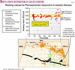
Coalbed gases desorbed from a well in the southern end of the Forest City basin in eastern Kansas11 yield calculated heating values ranging from 860 to 1,079 BTU/scf. This range is comparable to that produced by traditional Cherokee Group gas wells (Fig. 4).
Whether coal gases will also mimic the regional trends in BTU content for nearby conventional gas reservoirs has yet to be determined, but at least some of the gas in conventional gas fields has been sourced by coals. Recent work by Stoeckinger15 documented that channel sandstones truncating coals in southeastern Kansas can be charged with gas generated by these coals, and vice versa.
A group of relatively higher-BTU gases in the tier of counties along the Oklahoma state line (Fig. 4) indicates these gases have a greater proportion of heavier hydrocarbon gases (i.e., wet gas), such as ethane, propane, and butane. This may be caused by greater thermal maturity of Pennsylvanian strata in this area16 and also possibly by wet gases that may have migrated northward out of deeper strata in Oklahoma.
Coalbed gases, because they are also subject to these geological conditions in this region, may also have greater BTU content relative to production farther north. Coals farther upsection from the Cherokee Group may contain gases having lower BTU content, for this pattern appears to be the case for conventional reservoirs (Fig. 4).
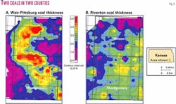
Detailed mapping and stratigraphic interpretations of individual coals will be critical in any exploration program. The Weir-Pittsburg coal, for example (Fig. 5), markedly changes thickness over distances of just a few miles, whereas Riverton coal in the same area is thinner but more consistent. Through such detailed mapping, depositional trends and related production fairways can be determined and factored into leasing and resource evaluation.
Variations in coal quality, thickness, and lateral distribution will be better understood by placing Cherokee Group coals within a sequence-stratigraphic framework. Lange17 (in progress) notes that these coals accumulated in a variety of depositional settings such as marsh, back-barrier marine, fluvial floodbasin, and interdistributary deltaic environments.
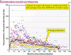
Gas production data in Kansas for coalbed gas leases to date are only cursorily compiled, as the type of gas production (i.e., traditional or coalbed gas) for any well permit or lease was not originally required of operators. However, monthly production figures for single-well leases (Fig. 6) reveals the presence of coalbed gas production because peak production for these wells typically occurs several months after initial production (as opposed to peak production with conventional wells, which occurs almost immediately after production begins).
Production in coalbed gas wells typically peaks in 1-3 years after start and slowly declines for years. The rate of production can greatly vary from well to well, but the best wells may produce 350 Mcfd at their peak. Average daily production during peak time for all wells considered (minimum 50 Mcfd for at least 3 years) is about 90 Mcfd (Fig. 6). The systematic classification and analysis of these data according to location, depth, and stratigraphic horizon may reveal production fairways and sweet spots that have hitherto gone unnoticed.
Data sources
Data available from years of oil and gas drilling can be utilized to provide reliable regional correlation of major coal beds and discern their thickness, depth, and structural deformation, as well as ancillary information on bottom-hole temperatures and pressure tests.
Wireline logs, drillers logs, and scout cards, archived at the Kansas Geological Survey in Lawrence, Kan., and Kansas Geological Society in Wichita are good data sources. Cores and well cuttings are also archived at Kansas Geological Survey facilities in Lawrence and Wichita. Drilling permit information is readily available online from the Kansas Corporation Commission. Many consultants have extensive personal data collections, born of years of local petroleum experience.
Summary
Coalbed gas from Middle Pennsylvanian rocks in eastern Kansas is an emerging new energy play.
Many of the critical geological parameters that will prove to be the major controls on the production fairways of this potential new resource have yet to be determined. Nevertheless, preliminary analyses indicate that recent leasing and exploration may translate into long-term production of new gas resources in what was hitherto considered a supermature petroleum province.
Acknowledgments
The authors are grateful to Jennifer Sims and Patricia Acker for graphics arts and file formatting support for illustrations in this article.
References
- Energy Information Administration (http://www.eia.doe/gov/oilgas/fwd/cr2000.html), "U.S. crude oil, natural gas, and natural gas liquids reserves 2000 Annual Report," 2000 (accessed 1/2002).
- Scott, A.R., "Coalbed exploration strategies; where is the next play?," Kansas Geological Society Bull., Vol. 76, No. 5, 2001, p. 9.
- Nelson, C.R., "Changing perceptions regarding the size and production potential of coalbed methane resources," Gas Research Institute, Gas Tips, Vol. 5, No. 2, summer 1999, pp. 4-11.
- Haworth, E., "Special report on oil and gas," University Geological Survey of Kansas, Vol. 9, 1908, 586 pp.
- Brady, L.L, "Eastern Kansas- some considerations for coalbed methane," Proceedings of the Rocky Mountain Association of Geologists Coalbed Methane Symposium, June 19, 2002, Denver, 5 pp.
- Stevens, S.H., and Sheehy, L.D., "Western Interior Coal Region (Arkoma, Cherokee, and Forest City basins)," in "Coalbed methane—state of the industry," Gas Research Institute, Quarterly Review of Methane from Coal Seams, Vol. 11, No. 1, 1993, pp. 43-48.
- Brady, L.L., "Kansas coal resources and their potential for coalbed methane," in McMahan, G., ed., Transactions of the AAPG Mid-Continent Section Meeting, Sept. 14-16, 1997, Oklahoma City, pp. 150-163.
- Stoeckinger, W.T., "Kansas coalbed methane comes on stream," OGJ, June 4, 1990, pp. 88-90.
- Tedesco, S.A., "Coalbed methane potential assessed in Forest City basin," OGJ, Feb. 10, 1992, pp. 68-72.
- Brady, L.L., and Guy, W.J., "Coal resources and coalbed methane potential in the Kansas portion of the Forest City basin," abs., AAPG Bull., Vol. 83, No. 7, 1999, pp. 1,193-94.
- Bostic, J., Brady, L., Howes, M., Burchett, R., and Pierce, B.S., "Investigation of the coal properties and the potential for coal-bed methane in the Forest City basin," U.S. Geological Survey, Open-File Report 93-576, 1993, 44 pp.
- Stoeckinger, W.T., "Methane from coal in southeast Kansas; the rebirth of an old industry," proceedings of the 1989 Coalbed Methane Sympoium at University of Alabama, Tuscaloosa, 1989, pp. 211-217.
- Rice, D.D., "Composition and origin of coalbed gas," in Law, B.E., and Rice, D.D., "Hydrocarbons from Coal," AAPG Studies in Geology No. 38, 1993, pp. 159-184.
- Jenden, P.D., Newell, K.D., Kaplan, I.R., and Watney, W.L., "Composition and stable isotope geochemistry of natural gases from Kansas, Midcontinent, USA," Chemical Geology, Vol. 71, No. 1-3, 1988, pp. 117-147.
- Stoeckinger, W.T., "Gas in an incised valley, Upper Cherokee age, eastern Kansas," abs., in "Finding and Producing Cherokee Reservoirs in the Southern Midcontinent—A Workshop," May 14-15, 2002, Oklahoma City, Oklahoma Geological Survey and US Department of Energy, p. 30.
- Hatch, J.R., and Newell, K.D., "Geochemistry of oils and hydrocarbon source rocks from the Forest City basin, northeastern Kansas, northwestern Missouri, southwestern Iowa, and southeastern Nebraska," Kansas Geological Survey Technical Series 13, 1999, 32 pp.
- Lange, J.P., "Stratigraphy, depositional environments and coalbed methane resources of Cherokee Group coals (Middle Pennsylvanian)-southeastern Kansas," unpub. MS thesis, University of Kansas, Lawrence, Kan., in prep.
The authors
Dave Newell (dnewell@kgs. ukans.edu) has researched stratigraphy, diagenesis, and petroleum geochemistry at the Kansas Geological Survey since 1982. Before this, he worked 6 years in exploration with Mobil Oil in Dallas and Aramco in London. He has a BS in geology from Indiana State University, an MS from the University of Wisconsin, and a PhD from the University of Kansas.
Lawrence L. Brady is a senior scientist with the KGS, where he has worked for 31 years in geologic research. His professional experience also includes teaching as an assistant professor of geology at Oklahoma State University and as an engineering geologist with the US Army Corps of Engineers. Brady holds a BS in geology from Kansas State University and an MS and PhD in geology from the University of Kansas.
Jonathan Lange is a graduate research assistant with the KGS, where he is working towards an MS in geology from the University of Kansas. He is researching the stratigraphy and depositional environments of the Cherokee Group coals in southeastern Kansas. He has a BS in geology from Kansas State University.
Tim Carr worked for 13 years at ARCO Oil & Gas Co. in research and exploration. Since 1991, he has been chief of petroleum research at the KGS, co-director of the Energy Research Center, and adjunct professor of geology at the University of Kansas. He has a BS in economics and a PhD in geology from the University of Wisconsin and an MS in geology from Texas Tech University.
