Iowa Forest City prospect may be large Paleozoic trap
A 1930s type oil field prospect exists in the Forest City basin in southwestern Iowa.
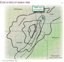
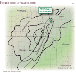
This isolated graben-type filled depression of carbonates is in the shallow Paleozoic Silurian-Devonian Hunton petroleum trend whose northern two oil traps are represented by Falls City and Barada oil fields in Richardson County, southeast Nebraska. There, initial oil production was 50 to 900 b/d of oil from 2,400 ft (Fig. 1).
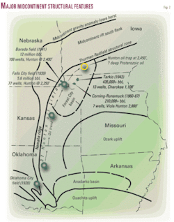
The 1930s type oil field prospect area is an extension of a proven oil field trend line that was developed by drilling thousands of wells into Paleozoic sediments from giant Oklahoma City field to Barada field, a distance of 200 miles or more (Fig. 2).
On the other hand, one deep well 100 miles north of the oil prospect has established the genetic petroleum system set forth by recent erudite academic authors.
Detrital sediments penetrated by one well, Amoco Eischeid-1, in 6-83n-35w, Carroll County, Iowa, drilled to 17,851 ft in 1986, established the Proterozoic Nonesuch shale as an enormous oil source zone for deep clastic enigmatic “reservoir” rocks and younger.
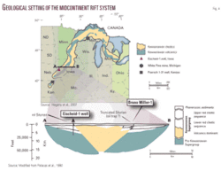
The genetic relation of the Nonesuch shale Proterozoic oil source zone and basin clastics is set forth on the left side of Fig. 3.
Petroleum system—Proterozoic
The potential petroleum system consisted of 12,178 ft of clastic sediments in a Proterozoic depression above Unit C, the Nonesuch shale oil source zone as depicted on the north side of the horst, MGA.
The 600 ft thick Nonesuch shale source bed equivalent was logged at 15,000 ft below surface in the Eischeid well. Its age was logged at 1,000-1,100+ Ma.1
The Eischeid well logged the Devonian at 1,200 ft. An unconformity was logged at 400 Ma. Devonian was lying on Ordovician 1,630 ft. No Silurian sediments were logged on the north flank of the horst in the graben.
Petroleum play—Paleozoic
On the right side of Fig. 3, the Silurian zone missing in the Eischeid well was logged at 2,470 ft below kelly bushing in the Bruno Miller-1, in 24-72n-39w, Montgomery County, Iowa, in 1988. TD below KB was 3,610 ft, 10 ft into arkosic Cambrian sandstone.
Devonian is lying on Ordovician in 24-72n-39w.
Hunton oil trap
The Midcontinent geophysical anomaly (MGA) consists of a horst in the middle, a basin to the north, and a basin to the south (Fig. 4).
The MGA is 1,000 miles long and 100 miles wide. The Nonesuch Lake has been postulated to have been on the same order of magnitude, a huge oil source environment that developed over geologic time.
The Bruno Miller-1 well was drilled on the south side of the horst in the Paleozoic sedimentary basin, graben, major depression, Forest City basin.
Note that porous Silurian carbonates are present on the south flank of the MGA, Iowa horst (right side of Fig. 3, and Figs. 4 and 5), 5½ miles south of 24-72n-39w, in 18-71n-38w[A], and they are truncated in 24-72n-39w.
Oklahoma City oil field
Oklahoma City field is a giant because of its location near the south end of the buried mobile basement feature—the Nemaha ridge—and its intersection with the northeast rim of the Anadarko basin.
The prominence of the uplift provided the environment for the development of very large flanking stratigraphic traps in the Siluro-Devonian Hunton limestone.2
Oil trend discoveries
The Hunton oil trend line begins with Oklahoma City field (Fig. 2).
A Silurian oil trap question to be answered is whether the 200-mile proved oil trend of Hunton oil traps, which follow the Nemaha ridge, where truncated at the even larger buried mobile feature the Midcontinent rift, a 40+ mile extension, provide the environment for the development of very large flanking traps in the Hunton, and thus the potential for a major Hunton truncated oil trap in Iowa?
1. Play evaluation (shallow-Paleozoic).
The Hunton stratigraphic unit exists from Oklahoma City field in the Anadarko basin to Falls City and Barada fields in the Forest City basin. The 200-mile underlying, controlling, structural, tectonic, petroleum accumulation “buried mobile feature” was the Nemaha ridge. Extension of the trend line intersects the Silurian zone with the MGA.
2. Genetic evaluation (deep-Proterozoic).
Underpinning a reliable petroleum system model for the Midcontinent rift system, Hegarty et al.1 set forth the criteria for the huge deep Nonesuch shale as an oil source bed, which is often quoted as having a remarkable low temperature history with oil dripping from the shale zone in a copper mine to the north.
The Iowa Geological Survey3 echoed the petroleum source rock and the obscure potential detrital overlying Proterozoic petroleum system.
But there is not one word in regard to the known Hunton oil traps within the 0 to 500-ft contours of Fig. 1 and the Silurian truncation with intersection of the Midcontinent rift and associated tectonic events in either article; Paleozoic play evaluation was not intertwined with the Proterozoic petroleum system study, although they intertwined at depth in 24-72n-39w.
Stratigraphy
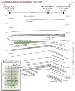
Stratigraphic control for Fig. 5 comes from three induction “E” logs.
A' and A'' surface geographical location overlie the deep-seated mobile feature as depicted in Fig. 5, the south flank of the Iowa horst and contiguous graben. The Thurman-Redfield structural zone was a linear series of domes, basins, and anticlines in Paleozoic rocks atop the south flank of the Midcontinent rift.
Western Seismograph 1984 regional gravity and magnetic surveys have all left their signatures for these features at the location of the Bruno Miller-1 (4-3-88) and the Ozona Brown-1 (5-19-08) in 24-72n-39w.
Zero time line was the top of Silurian porosity zone as depicted in [A] Teague Phelps-1 (8-12-84), which was 209 ft structurally low to truncated Silurian in [A'], a potential oil column of 200 ft, 40 ft of Silurian porosity, gross 80 ft eroded off the truncated Silurian [A] zone which is truncated at [A'] and [A''].
The Ordovician Maquoketa was below porous Silurian in Phelps-1 [A]. At updip truncation of Silurian, A'-A'', less than 5½ miles north, Devonian argillaceous carbonates (cap rock) are lying on older Maquoketa members, i.e., a potential stratigraphic oil trap to the south (Fig. 5).
The addition of 184 ft of Maquoketa sediments below the erosional unconformity within the 1 mile distance between A' and A'' suggests that the exact location of forced folds, which were formed by fault blocks simply pushing up the overlying sediments and then erosion and nearby detrital accumulation, may be depicted in 24-72n-39w.
Note that the tectonic activity and subsequent increase in deposition stopped at the base of the Devonian, zero time line. Thus, there may be a major Silurian truncated oil trap to the south (Figs. 3-5).
Method of discovery
The source of Hunton oil trap exploration as depicted in Fig. 5 was as tangible as it can get.
A mineral core hole driller extracted three core hole logs from a file-cabinet identified by well numbers only. Two logs described very porous cores saturated with high gravity oil. The depth was more than 2,400 ft. A third hand-written (field copy) log described thick asphalt at 1,900 ft where the core hole was “lost.”
During the 1980s, a core hole driller drilled core holes with three Longyear-type rigs exploring for lead and zinc in Iowa, Kansas, Oklahoma, Tennessee, and Kentucky. He reported to the author and others, “The two cores in Iowa had more high gravity oil recovered than all the others combined.”
In Cumberland County, Ky., some core holes produced 500 b/d of oil from 1,500 ft below surface from eroded Ordovician Knox hills.
Possible analogs
Fig. 5 is a stratigraphic cross-section that depicts the stratigraphic Hunton (updip) truncation that flanks the south Midcontinent rift system as set forth for this type petroleum deposit zone of the Paleozoic that fits the model exactly of criteria set forth by giant Oklahoma City field for the Hunton.
Oklahoma City field is 12 miles long and 4½ miles wide. The Iowa Silurian Hunton prospect is 4+ miles north-south. No well has been drilled for 10 miles east or west of the potential Silurian oil trap within the limits graphically defined in Fig. 5 and within the 0 to 500-ft Silurian contours of Fig. 1 and on strike with the MGA.
The Silurian prospect is for an independent oil company looking for an oil trap with 20 million bbl of oil potential, more or less, at a shallow depth, in a large oil producing sedimentary-structural depression that is an extension of a 200-mile oil trend.
The deeper underlying Proterozoic petroleum system is also exactly defined by Fig. 5. The thermal history of the Nonesuch shale obtained from the Amoco Eischeid well drilled in 1986 penetrated 15,000 ft of Proterozoic clastics that may be suitable for hydrocarbon exploration.
Western Seismograph indicated that these same basin type sediments are below the 24-72n-39w area, on the MGA south flank, and above a deep-seated mobile feature; they are also on the hydrocarbon production trend line in this government section.
Hegarty et al.1 wrote, “Two outstanding attributes of the Midcontinent rift system led geologists to the widely held model that the Phanerozoic was tectonically quiescent,” which may be academic cant. Above the erosional unconformity, base Devonian through Pennsylvanian sedimentation correlation was flat.
Immediately below the unconformity and base of Maquoketa Group within less than a mile is an additional 184 ft of sediments that may indicate contiguous force folds and faulting from Nonesuch shale through Upper Ordovician, not Phanerozoic and younger tectonic quiescent, but possible deep source beds with migration paths, solution trends, of oil for a defined Forest City basin Silurian Hunton oil trap. The same area lies at the end of an established oil trend line for the deep “enigmatic” Midcontinent rift petroleum system.
Robinson field was the first and largest oil field discovered in Illinois. Erudite geologists of the Standard oil companies informed the wildcatter Mike L. Benedum, that his trend line had been tested and found to have no merit.4
More than 100 number 1 wells in a few months proved that the correct trend line in Illinois was all that was needed for the first Illinois giant oil discovery.
Similarly, perhaps it will take shallow Paleozoic trend wells to discover and develop the Silurian oil trap extension of the Forest City basin oil trap(s) for the first oil field(s) in Iowa? Or will the deep elusive Phanerozoic petroleum system at the termination of a Paleozoic oil trend produce a huge oil discovery for the first oil field in Iowa? Or maybe they both share the same deep oil source?
Two updip Silurian truncated wells have been drilled. The downdip well with Silurian porosity has been drilled. The geographical area in between is yet to be tested with a single well drilled for Hunton trapped oil.
References
- Hegarty, Kerry A., et al., “Direct measurement of timing: Underpinning a reliable petroleum system model for the Mid-Continent rift system,” AAPG Bull., Vol. 91, No. 7, July 2007.
- Gatewood, Lloyd E., “Oklahoma City field—Anatomy of a Giant,” in “Geology of Giant Petroleum Fields,” Michel T. Halbouty, ed., AAPG Memoir 14, 1970, pp. 223-254.
- “Exploring the Midcontinent Rift,” Iowa Geological Survey, Iowa Department of Natural Resources, Iowa City, Iowa, Fact Sheet 2006-2.
- Mallison, Sam T., “The Great Wildcatter, The Story of Mike Benedum,” Education Foundation of West Virginia Inc., Charleston, 1953.
Bibliography
Palacas, J.G., et al., “Petroleum source-rock assessment of Middle Proterozoic (Keweenawan) sedimentary rocks, Eischeid #1 well, Carroll County, Iowa,” Iowa Department of Natural Resources, Geological Survey Bureau, Special Report Series No. 2, 1990, pp. 119-134.
Western Seismograph, 1987, speculative seismograph line 2, Page-Montgomery County, Iowa, deep-seated igneous, sedimentary depositional basin.
The author
George H. Miller ([email protected]) is a consulting petroleum geologist in Brady, Tex. He has more than 50 years of oil and gas industry experience and has been consulting since 1962. He started with Plymouth Oil, a Benedum-Trees company, as an analog seismograph plotter and later as geologist for North Louisiana, Arkansas, and East Texas. He has also worked the Cincinnati arch. He has an MS in geology from Texas A&M University.
AustraliaTexalta Petroleum Ltd., Calgary, plans to shoot seismic on Exploration Permits 103 and 104 in the frontier Georgina basin in Australia’s Northern Territory under a renegotiated farmout.
Texalta renegotiated terms of its late 2007 farmout with Officer Basin Energy Pty. Ltd., a subsidiary of Rodinia Oil Corp. Officer Basin Energy plans to assign its rights to Australia Energy Corp., newly incorporated with the same management as Rodinia Oil.
The work commitment is for 100 line-km of seismic on Permit 103 and 50 line-km on Permit 104.
MoroccoSan Leon Energy PLC plans to negotiate with Morocco’s ONHYM to convert its Zag reconnaissance license into an exploration license.
San Leon said a high-resolution aeromagnetic survey integrated with surface and subsurface data indicated large structures, including a 60-km anticline with hydrocarbon potential.
RWE-Dea took a farmout on the license just north of San Leon’s Zag license. San Leon operates Zag with 50% interest, Longreach Oil & Gas has 30%, and Island Oil & Gas PLC has 20%.
AlaskaOooguruk field off Alaska’s North Slope reached giant status when operator Pioneer Natural Resources Co., Dallas, hiked the field’s net resource potential last month.
Pioneer hiked Oooguruk’s resource potential to 120-150 million boe net to its 70% interest from the previous estimate of 70-90 million boe. Eni Petroleum Inc. holds 30% interest.
Production, 3,000 b/d at the end of 2008, was expected to rise gradually to 10,000-14,000 b/d in 2011 and average 5,000 b/d in 2009. Pioneer is reevaluating the 2009 estimate after the initial production rate at the most recent development well was about 7,000 b/d.
Oooguruk is being developed from a gravel island in Harrison Bay 5 miles northwest of Oliktok Point.
UtahNo appreciable drilling success came from Delta Petroleum Corp.’s first three exploratory wells in the Utah Hingeline play other than to establish that oil appears to have migrated through the region, the company said.
The company impaired 90% of its acreage cost basis and believes it has condemned only six of the 21 intially identified structural features.
Delta, with 65% interest in the acreage, will likely seek further joint venture participation in Utah as it focuses a majority of its capital expenditures on lower risk projects.
WashingtonHigh mud weights were required to control gas flows in several sandstone intervals in Delta Petroleum Corp.’s Gray 31-23 exploratory well in the Columbia River basin of Washington.
The gas column in the Kittitas County well appears to be much higher in the stratigraphic section compared with other wells in the basin, the company said. Delta expects to reach total depth by early April.
The well “has encountered numerous sandstones that contain several hundred net feet of porous and permeable sands based on wireline logs and core analysis. Porosities range from 12% to 17% with an average of 14% and permeabilities are very good and range from 27 md to 107 md,” Delta said.
“Volumetric calculations based solely on logs and cores indicate the potential for significant gas volumes, and completion results will provide the necessary information to generate reserve estimates,” Delta added.
The Denver company has begun permitting efforts for a second well but plans no further capital commitments it finishes the Gray well.
