Historical production trends suggest remaining upside for E&D in Michigan
In spite of being a small player on the world petroleum stage, Michigan has attracted considerable attention over the years and continues to be a haven for companies searching for oil and gas prospects with reserves on the order of 500,000-1 million bbl of oil equivalent.
Recent jumps in commodity prices to nearly $60/bbl for oil and $7/Mcf for gas may further lower economic thresholds for prospects and development projects in the state. It seems reasonable that a high number of 1 million bbl and smaller fields and perhaps a few multimillion barrel fields or plays remain to be discovered.
In this article, we present newly compiled historical production data and use the data to review 10 important oil and gas plays in the Michigan portion of the Michigan basin. New ideas, old-fashioned prospecting, and the application of technology (combined with prudent business and regulatory practices and a bit of luck) have played and will continue to play important roles in the production results of the state.
Significant upside likely remains for increasing production and reserves by applying new and creative ideas for exploration in prospective formations, by improving recoveries from existing fields, and by applying appropriate technology.
Michigan production
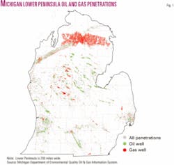
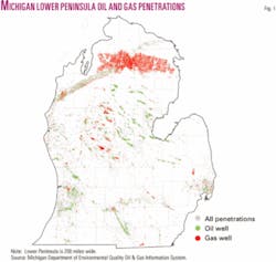
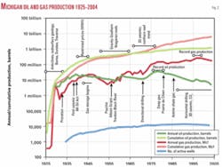
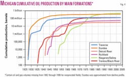
Cumulative oil and gas production (1925 to 2004) exceeds 1.2 billion bbl of oil and 6.0 tcf of gas in Michigan from more than two dozen plays located in Paleozoic carbonates and sandstones (Table 1 and Figs 1-2).
Michigan monthly production in December 2004 was 546,000 bbl of oil and 13.5 bcf of gas from more than 12,000 active wells.
Of this monthly total, Silurian Niagaran-Salina carbonate reservoirs contributed 227,000 bbl of oil and 1.7 bcf of gas. Middle Devonian Traverse-Dundee-Reed City-Detroit River-Richfield carbonate reservoirs contributed 293,000 bbl of oil and 0.1 bcf of gas.
Upper Devonian Antrim shale tight gas reservoirs contributed 10.8 bcf, Ordovician Prairie du Chien-Glenwood sandstone reservoirs contributed 5,600 bbl of oil and 0.7 bcf of gas, and Trenton-Black River carbonates contributed 5,000 bbl and 0.1 bcf.
Annual production statistics for Michigan were not published prior to 1932, but many early state geological survey reports contain clues and information regarding oil and gas shows and production from individual brine (salt), fresh water, core, oil, and gas well tests and from oil and gas fields drilled before 1932.
The Michigan Department of Environmental Quality (MIDEQ) online oil and gas information system lists more than 36,000 total historical and/or existing productive wells, more than 2,000 separate fields, and more than 2,150 separate reservoirs in the state.
These reservoirs produce from more than 30 MIDEQ reservoir designations, with names and abbreviations based upon geologic formation names and stratigraphic nomenclature (Table 1).1 2 The MIDEQ oil and gas database also lists more than 59,000 oil, gas, core, injection, and brine wells and/or deviated and horizontal well completions in Michigan.
Production database
In order to investigate the remaining potential of subsurface formations in Michigan, annual production data were methodically entered into spreadsheets from all the historical hard copy records published between 1934 and 1982 by the MIDEQ and its predecessors.
These spreadsheets were then combined into a standard query language database and merged with the 1982 to present MIDEQ online oil and gas information production database.3 4
Production volumes by formation from 1925 through 1933 were taken from summary tables presented in certain of the annual production reports. Associated gas volumes, however, are not available at this time during the early years of production for many Middle Devonian fields and reservoirs.
In addition, only prorated oil and gas monthly volumes were tracked between 1982 and 1996 in the online oil and gas database, but production from all wells was tracked beginning in 1997. Quality control of the production data continues at the present, and additional historical and new production data are added to the full database as they become available.
Mississippian-Devonian fields
Commercial quantities of oil and gas have been known in Michigan since at least 1886 when oil was produced from the Devonian Dundee limestone in the Port Huron area to make grease for buggy and wagon axles and natural gas was used for residential lighting.5 6
Exploration in the Saginaw area located oil in the Devonian Traverse and Dundee limestones and gas in the Devonian-Mississippian Berea sandstones as early as 1913, but it was not until 1925 that additional discoveries set off a town-lot drilling boom.6 7
By 1928, more than 300 wells had been drilled to the Berea and deeper, and Berea wells were shot with nitroglycerin in Saginaw field.6 Annual oil production in Michigan climbed from 4,000 bbl in 1925 to 435,000 bbl in 1927 (Fig. 2).
The discovery of gas and oil in the Devonian Traverse limestone on the Muskegon structure in Southwest Michigan in 1927 set off a drilling boom in the area just as Saginaw field was playing out.
Subsequent deeper drilling discovered oil in the Devonian Dundee limestone, and by 1929 Muskegon field had reached peak oil production of more than 18,000 b/d.8
Many of the wells were completed naturally, but acidizing was also employed. However, by 1932 production had declined to less than 1,200 b/d from the 466 wells due to overdrilling on town lots, early loss of pressure, and rapid edge-water encroachment.8
Simultaneously, in 1927 the confidential brine well records of the Dow Chemical Co. were released to the youthful Michigan oil industry in the Mount Pleasant area in Midland County.6 8 An anticline was mapped from these records below the glacial drift, and shows in the wells led the Pure Oil Co. to drill the Devonian Dundee limestone discovery well in 1928 after acquiring over 80,000 acres in the area.6 8
The Mount Pleasant discovery well came on for around 100 b/d of oil, but further development of the field to the east in 1931 resulted in wells that produced more than 3,000 b/d of oil.
By 1934, Michigan was producing more than 10 million bbl/year, and by 1939 it was producing more than 23 million bbl/year from more than 70 Middle Devonian discoveries (and proration was implemented to conserve the state’s oil and gas resources).
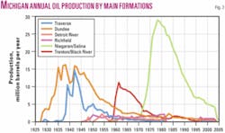
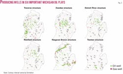
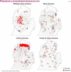
Additional discoveries based upon subsurface mapping and core drilling through the early 1950s (and later using seismic data) in the Berea, Stray, Traverse, Dundee, Reed City, Detroit River, Detroit River sour zone, and the Richfield continued to play important roles in the annual oil and gas production (Figs. 3-8).
Ultimate recovery from the Middle Devonian plays and reservoirs will likely exceed 1 billion bbl of oil equivalent (Fig. 4).
Future work is needed to understand diagenesis, facies, and production performance of dolomite and limestone lithologies-facies in Middle Devonian carbonate reservoirs.6-10 Detailed studies of existing fields may identify new infill and secondary and tertiary recovery targets, especially in the solution-gas reservoirs.11
Many Middle Devonian reservoirs are structural accumulations and are located along anticlinal trends related to faulting at depth. However, many other Devonian and Mississippian reservoirs (Stray, Berea, Traverse, Reed City, and Detroit River) have accumulated in stratigraphic traps, and most of these fairways are greatly underexplored.
Production from the Devonian Rogers City member of the Dundee limestone is combined with Dundee limestone production in the MIDEQ production database. However, Rogers City reservoirs have probably produced at least 25% (~75 million bbl of oil) of the total reported Dundee oil, based upon the correlations and drill cuttings studies of Cohee and Underwood.12
More recent work using well log curves has correlated the Rogers City member as well as the Reed City member of the Dundee limestone in central and western Michigan,13 but additional detailed sequence stratigraphic analysis may identify additional facies tracts with multiprospect potential.
Trenton-Black River fields
Ordovician Trenton and Black River reservoirs have produced more than 138 million bbl of oil and 275 bcf of gas from fractured dolomite reservoirs in southern Michigan (Table 1 and Figs. 3-5).
The majority of this production has come from the following five fields: Deerfield (discovered 1920 but not produced until 1935), Northville, the Albion-Scipio Trend, Hanover, and Stoney Point.14
Ordovician carbonate reservoirs typically occur as narrow, linear features and are stratistructural traps composed of hydrothermal dolomite in regionally tight limestone. Many of these reservoirs are offset along their trace due to wrench faulting induced Riedel shears.15
Porosity and permeability vary widely in these fracture-related accumulations. There is significant remaining space for the narrow Albion-Scipio and Stoney Point-type fractured Ordovician reservoirs between existing well control in Michigan. Stoney Point (12 million bbl recoverable), for example, was not discovered until 1982.
Current exploration in the northeastern U.S. and southeastern Canada is enjoying commercial success in Trenton-Black River reservoirs using horizontal wells and new ideas regarding tectonics and the timing of formation of structures.
Silurian Niagaran fields
The Silurian Niagaran reef play is the most important and spectacularly successful play in Michigan, with cumulative production of 475 million bbl of oil and 2.8 tcf of gas.
The play is more than twice the size of the Devonian Dundee play. However, if the cumulative production is combined for all Middle Devonian carbonate plays, then the Middle Devonian carbonates and the Silurian Niagaran pinnacle reef plays are roughly equal in size (Table 1 and Figs. 3-5).
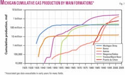
About 1,250 total fields in the Salina (20), A2 Carbonate (5), A1 Carbonate (20), and Brown Niagaran (1,200) are described in the MIDEQ production database, and 490 are classified as gas fields and 730 as oil fields. Ultimate recovery from the Niagaran play will probably exceed 1 billion boe from more than 1,000 individual pinnacle reefs (Figs. 1,4, and 7).
The first Niagaran discovery in Michigan occurred by accident in 1927 in St. Clair County when the Diamond Crystal Salt Co. encountered gas while drilling a well for salt.16
The first reported oil production from the Southern Niagaran Reef Trend was in a well in Dorr field in Allegan County in 1937.17
The first oil production from the Northern Niagaran Reef Trend occurred in 1952 from a well in the middle of the trend (Brazos, HE-1 State-Chester), but the well was abandoned in 1956 after producing just 2,700 bbl of oil.17
Beginning in the late 1940s, gravity methods were used to locate more than 90 reefs beneath glacial drift deposits in Southeast Michigan and Ontario.18 However, as the southern Niagaran reef play moved westward, significant variations in the thickness and composition of the glacial drift made gravity data and single-fold seismic data unreliable.18
It was the use of common depth point seismic data that solved the glacial drift problems in the play for Mobil, Shell, and Amoco (among others) and led to the westward development of the Southern Niagaran Reef Trend and the successful exploration of the Northern Niagaran Reef Trend (Fig. 5). By the mid-1980s the quality of seismic data had greatly improved because of modern processing, higher fold data, and improved acquisition parameters.
New ideas, new interpretation schemes, and new techniques to improve the seismic expression of reefs in legacy and new seismic data (combined with old-fashioned subsurface prospecting) will continue to locate profitable prospects in this play (Fig. 4).19-22
Niagaran pinnacle reef reservoirs recover 15-35% of the original hydrocarbons in place during primary recovery, and based upon 55 Michigan waterflood projects, secondary recovery practices may recover another 20% of the original hydrocarbons in place.23 Tertiary recovery using carbon dioxide from Devonian Antrim shale waste gas has also been used to increase recoveries from these reservoirs (e.g., Dover 33, 35, and 36 fields, Otsego County).
Niagaran reefs make excellent gas storage reservoirs, and 39 reefs in Michigan are currently used for storage.24 The proper placement of deviated and horizontal wells to reach undrained and poorly connected reservoir compartments has also improved recoveries and deliverabilities from these fields.25-27
Prairie du Chien deep gas
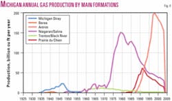
Gas in the Ordovician Prairie du Chien Group, the St. Peter sandstone, and the Glenwood formation was commercially discovered in 1981, and more than 75 of these fields have produced 15 million bbl of oil and 600 bcf of gas through 2004 (Table 1 and Figs. 6-7).
The slope of the cumulative gas curve for this play suggests significant remaining potential (Fig. 7). Average reservoir properties for these multipay sandstone targets include porosities of 6-10%, permeabilities of 10-20 md, and water saturations of 25-35%.28
Subsurface mapping and the interpretation of seismic data (e.g., isopach thin between the Dundee and Prairie du Chien) are important tools for locating productive reservoirs.29 To date, most Prairie du Chien production has been found directly beneath or slightly offset from anticlinal features in Middle Devonian strata.
Barnes30 concluded a thick Middle Ordovician stratigraphic sequence is present in the Michigan basin depocenter, and that lack of penetrations and detailed biostratigraphy have led to uncertain subsurface correlations. Transitional contacts, lateral and vertical facies changes, and complicated subsurface nomenclature in these stacked and burrowed sandstones (e.g., Prairie du Chien, St. Peter sandstone, Glenwood shale, among others) indicate significant remaining upside for gas and condensate production in stratigraphic traps and subtle structural traps.
A thrust structure with repeated A1 Carbonate containing high-pressure gas was discovered while drilling in the Au Gres field in Arenac County and could indicate a new and prospective structural paradigm.31
Devonian Antrim shale gas
The Devonian Antrim shale has produced more than 1.8 tcf of gas since tax credits and drilling success made the play attractive in the mid-1980s (Table 1 and Figs. 1-2, 6, and 7).
About 9,000 wells have been drilled in the Northern Antrim Trend (Fig. 8) to produce biogenic and thermogenic gas from sets of well-developed fractures.32
Most wells are completed in the Norwood and Lachine members using staged fracture stimulations. Mud log gas shows, penetration rates, and velocity and resistivity image logs are used to locate the thin vertically fractured intervals for perforation. Antrim shale wells initially produce with high water rates.
The Antrim play has been extended to the western portion of the northern production trend, and gas production in Manistee County is likely from the correlative Devonian Ellsworth shale.33 Shows of gas in the Antrim shale have been observed in many areas of Michigan, suggesting the possibility of additional productive areas, but most drilling outside the northern trend has been at best marginally successful or unsuccessful to date.
The projection of the cumulative production curve for the Antrim shale suggests that the play could have ultimate recovery of several trillion cubic feet of gas (Fig. 7). Horizontal drilling to intersect fractures and new completion technologies, like those being applied to the Barnett shale in the Fort Worth basin in Texas, could greatly expand the Antrim play.
Future play opportunities
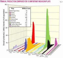
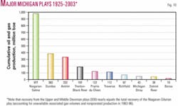
From 1925 to present, Michigan has produced a little over 2.2 billion boe from nearly 2 dozen plays.
Of these, the following five plays account for over 88% of the total production (Figs. 9-10):
- The Silurian Niagaran pinnacle reefs (43%).
- The Devonian Dundee carbonates (17%).
- The Devonian Antrim Shale (15%).
- The Ordovician Trenton-Black River fractured reservoirs (8%).
- The Prairie du Chien Group (5%).
Combining all Upper and Middle Devonian reservoirs (41%) into one play brings the production from the five plays to 97% of the total hydrocarbons produced to date. On a world scale, the Niagaran reefs and the combined Devonian reservoirs will likely qualify for giant field status, based upon projection of ultimate recoveries from the cumulative production curves (Figs. 4 and 7).
The steep slopes on the cumulative production curves for the Niagaran, Antrim, and Prairie du Chien plays suggest that important undiscovered resources may remain in these formations. The flat slopes on the cumulative production curves for the other plays in Michigan could indicate that there is not much potential left for undiscovered resources, or undiscovered resources are still present but new technology and-or new ideas are needed to find the hydrocarbons.
Discoveries of gas in the Lower Silurian Burnt Bluff and in the Clinton formations suggest that some exploration geologists may have new ideas regarding the oil and gas opportunities in these intervals.34 35 New paradigms regarding the Lower Devonian Sylvania sandstone could also lead to new discoveries.
Ideas regarding sequence stratigraphy, modern analogs, and hydrodynamics could be used to reevaluate the Silurian Niagaran Pinnacle Reef Trend from new and contrarian viewpoints to discover additional resources.
The potential for oil and gas accumulations in the Cambrian sandstones in Michigan is largely unknown because only about 200 wells have penetrated the interval.36 Anticlinal structures related to reactivation of basement faults are likely targets for hydrocarbon entrapment.37
Application of new advances in 2D and 3D seismic processing techniques, including spectral decomposition to understand the seismic signatures of Middle Devonian and Trenton-Black River fracture-controlled reservoirs as well as other stratigraphic intervals in Michigan, could improve conventional subsurface analysis and locate new productive trends.21 38
New drilling and completion technologies applicable to fractured reservoirs and tight-gas reservoirs could extend the Antrim shale play to other areas of the state. Finally, tantalizing shows have been observed in many other stratigraphic intervals in Michigan, suggesting that rich opportunities exist for exploration geologists who can recombine, reinterpret, and reintegrate the historical data to develop new ideas for plays and prospects.
Acknowledgments
We thank Carol Asiala for the Visual Basic programming and database manipulation. The Michigan Department of Environmental Quality provided well location and production data. IHS Energy Log Services provided digital well logs. Landmark Corp. provided the GeoGraphix mapping and cross section software through its University Grant program. Parts of this work were supported by DOE contract DE-FC26-00BC15122. Acknowledgment is made to the donors of the American Chemical Society Petroleum Research Fund for partial support of this research.
References
- Catacosinos, P.A., Harrison, W.B., III, Reynolds, R.F., Westjohn, D.B., and Wollensack, M.S., “Stratigraphic nomenclature for Michigan,” Michigan Department of Environmental Quality, Geological Survey Division, 2000, 1 sheet, < http://www.deq.state.mi.us/documents/deq-gsd-info-geology-Stratigraphic.pdf>, accessed June 4, 2004.
- Catacosinos, P.A., Harrison, W.B., III, Reynolds, R.F., Westjohn, D.B., and Wollensack, M.S., “Stratigraphic Lexicon for Michigan,” Michigan Geological Survey Bull. 8, Department of Environmental Quality and Michigan Basin Geological Society, 2001, 56 pp.
- Michigan Department of Environmental Quality, 1934-86, “Michigan’s oil and gas fields,” annual statistical summaries, Department of Natural Resources, Geology Division, Lansing, Mich., multiple yearly reports.
- Michigan Department of Environmental Quality (MIDEQ), 2004, Online oil and gas information system: http://www.deq.state.mi.us/mir/, accessed June 4, 2004.
- Catacosinos, P.A., Daniels, P.A., Jr., and Harrison, W.B., III, “Structure, stratigraphy and petroleum geology of the Michigan Basin,” in Leighton, M.W., Kolata, D.R., Oltz, D.F., and Eidel, J.J., eds., “Interior cratonic basins,” AAPG Memoir 51, 1991, pp. 561-602.
- Michigan Oil & Gas Association (MOGA), “Michigan oil and gas story, county by county,” privately published, Michigan Oil & Gas News Inc., Mount Pleasant, Mich., 1991, 208 pp.
- Smith, R.A., “The occurrence of oil and gas in Michigan,” Michigan Geological & Biological Survey, Pub. 14, 1912, 281 pp.
- Newcombe R.B., “Oil and gas fields of Michigan,” Michigan Geological Survey, Pub. 38, 1933, 293 pp.
- Harrison, W.B., III, “Reservoir characteristics controlled by depositional facies and diagenesis, Devonian System of Michigan Basin,” abs., AAPG Bull., Vol. 73, No. 8, 1989, p. 1,033.
- Harrison, W.B., III, “Dundee field production history and reservoir performance in relation to reservoir type,” abs., AAPG Bull., Vol. 85, No. 8, 2001, p. 1,532.
- Maness, T.R., “Regional depositional control on Dundee Reservoirs in the Michigan Basin,” abs., AAPG Bull., Vol. 85, No. 8, 2001, p. 1,535.
- Cohee, G.V., and Underwood, L.B., “Lithology and thickness of the Dundee Formation and the Rogers City Limestone in the Michigan Basin,” US Geological Survey, Oil & Gas Investigations Map, 1945, Scale 1:1,000,000.
- Taylor, E.T., “Stratigraphic distribution of the Rogers City dolomitization across the west central region of the Michigan Basin,” abs., AAPG Bull., Vol. 85, No. 8, 2001, p. 1,539.
- Wylie, A.S., Jr., and Wood, J.R., “Map views of the producing formations in Michigan, the Michigan Basin, US,” abs., AAPG Eastern Meeting, Columbus, Ohio, Oct. 3-6, 2004.
- Hurley, N.F., and Budros, R., “Albion-Scipio and Stoney Point fields, USA, Michigan Basin,” in Beaumont, E.A., and Foster, N.H., eds., “Stratigraphic Traps I,” AAPG Treatise of Petroleum Geology, Atlas of Oil & Gas Fields, 1990, pp. 1-37.
- Mantek, W.E., “Silurian oil and gas potential of Michigan,” abs., Michigan Basin Geological Society symposium, Lansing, Mich., 1979, p. 9.
- Ells, G.D., “Michigan’s Silurian oil and gas pools,” Michigan Geological Survey, Report of Investigation No. 2, 1967, 49 p.
- Labo, J., Cousins, J., Werner, W.G., and Pan, P.H., “Exploring for Silurian-Niagaran pinnacle reefs in southern Michigan Basin,” OGJ, June 22, 1981, pp. 93-98.
- Pangborn, T.C., “The Michigan Niagaran reef trend still exciting and profitable,” Ontario Petroleum Institute, 22nd Annual Conference, 1983, 23 pp.
- Loveland, M.W., “Geophysics of the Michigan Basin-an overview of the seismology and geology of the northern Michigan reef trend and center basin gas play,” Interstate Oil Compact Commission Committee Bull., Vol. 28, No. 2, 1986, pp. 82-95.
- Partyka, G., Gridley, J., and Lopez, J., “Interpretational applications of spectral decomposition in reservoir characterization,” The Leading Edge, Vol. 18, No. 3, 1999, pp. 353-360.
- Esperson, T.B., Hardwick, A., Ratnett, N., and Sunderland, J., “Making the most of nonexclusive legacy seismic data-an example from the Southern North Sea,” accessed Feb. 15, 2005, http://www.tgsnopec.no/attachments/tech_art_Legacy.pdf.
- Brock, T., “Secondary recovery in Michigan reefs summary results, recovery achieved,” in “Engineering Applications for Michigan,” Society of Petroleum Engineers, Continuing Education Seminar, Mount Pleasant, Mich., Apr. 11-12, 1995, 30 pp.
- Michigan Public Service Commission (MPSC), “Michigan Natural Gas Storage Field Summary,”
, accessed Apr. 9, 2005. - Metzger, F.W., and Rowan, M.C., “Natural gas storage in a southeastern Michigan pinnacle reef,” abs., AAPG Bull., Vol. 85, No. 8, 2001, p. 1,536.
- Pearce, L.A., Hewitt, C.M., and Corder, L.M., “Horizontal drilling in the northern reef trend of the Michigan basin,” in Carr, T.R., Mason, E.P., and Feazel, C.T., eds., “Horizontal wells: Focus on the reservoir,” AAPG Methods in Exploration No. 14, 2003, pp. 193-213.
- Wylie, A.S., Jr., and Wood, J.R., “3D-Imaging of Core and Log Curve Amplitudes in a Niagaran Reef, Belle River Mills Field, St. Clair County, Mich., US,” AAPG Bull., Vol. 89, No. 4, 2005, pp. 409-433.
- Harris, J.W., Goter, E.R., McElhaney, M.S., and Sternbach, C.A., “Stratigraphy, depositional environments, and reservoir-seal relationships of the Prairie du Chien and St. Peter Formations (M. Ordovician) in the Michigan Basin,” abs., AAPG Annual Convention Program, 1992, pp. 51-52.
- Martinson, T.P., “St. Peter sandstone exploration in the Michigan Basin,” Ontario Petroleum Institute, 26th Annual Conference, 1987, 32 pp.
- Barnes, D.A., Harrison, W.B., III., and Shaw, T.H., “Lower-Middle Ordovician lithofacies and interregional correlation, Michigan Basin, USA,” in Witzke, B.J., Ludvigson, G.A., and Day, J., eds., “Paleozoic Sequence Stratigraphy-views from the North American Craton,” GSA Special Paper 306, 1996, pp. 35-54.
- DesAutels, D., “Thrust structure in Michigan could point toward more targets,” OGJ, Aug. 16, 1993, pp. 86-88.
- Curtis, J.B., “Fractured shale-gas systems,” AAPG Bull., Vol. 86, No. 11, 2002, pp. 1,921-38.
- Ells, G.E., “Stratigraphic cross sections extending from Devonian Antrim Shale to Mississippian Sunbury Shale in the Michigan Basin,” Michigan Geological Survey, Report of Investigations 22, 1979, 186 p.
- Maslowski, A., “New interest in Clinton and Trenton formations takes hold,” Northeast Oil Reporter, Vol. 3, No. 3, 1983, pp. 34-35.
- Harrison, W.B., III, and Jalkut, K., “Petrology, stratigraphy, and depositional environments of Burnt Bluff Group in Michigan,” abs., AAPG Bull., Vol. 69, No. 2, 1985, p. 263.
- Catacosinos, P.A., “Oil and gas potential of Michigan Cambrian,” abs., Michigan Basin Geological Society symposium, Lansing, Mich., 1979, p. 7.
- Harrison, W.B., III, and Atekwana, E., “Reservoir properties and hydrocarbon potential in Cambrian and Lower Ordovician strata in the Michigan Basin,” abs., AAPG Bull., Vol. 86, No. 9, 1997, p. 1,553.
- Budros, R.C., and Johnson, K.R., “Deep River and North Adams Fields-Devonian fracture-controlled dolomite reservoirs in the central Michigan Basin,” abs., AAPG Bull., Vol. 74, No. 8, 1990, p. 1,303.
This article is based in part on certain presentations from the joint Michigan Petroleum Technology Transfer Council, Michigan Basin Core Research Laboratory, and Michigan Oil & Gas Association workshop, “Petroleum Systems of the Michigan Basin-A Look at Remaining and Undiscovered Oil and Gas Resources,” Sept. 23, 2004, in Grand Rapids.
The authors
A. S. “Buddy” Wylie (aswylie @mtu.edu) prepared this article while a research scientist-engineer with Michigan Technological University and has since joined Cabot Oil & Gas Corp., Denver ([email protected]). He worked for19 years in petroleum exploration and reservoir characterization in a variety of positions for companies including Gulf, Chevron, Santa Fe Energy, and Mobil. His present interests include the continued development of log curve amplitude slicing and tomography for subsurface imaging of petroleum systems and reservoirs. He has MS and BS degrees in geology from North Carolina State University and a PhD from Michigan Tech.
James R. Wood is professor of geology at Michigan Technological University and director of its subsurface visualization laboratory. He was with Chevron Oil Field Research Co. from 1978 to 1990. His present interests include petroleum geology and surface geochemistry as well as computer-based mapping of the subsurface. He has a PhD from John Hopkins University.
