HOPEDALE BASIN-1: Favorable geology, advanced technology may unlock Labrador’s substantial resource
Michael Enachescu, Memorial University, St. John’s, Newf.
Several large gas discoveries were made along the Canadian Labrador shelf during an early exploration cycle that extended through the 1970s into the early 1980s. With the focus at the time being strictly on oil exploration, no development and no further drilling have occurred in the area since 1983.
That early drilling, which included only 27 wells (21 located in the Hope- dale basin) proved the presence of 4.2 tcf of recoverable natural gas in the five discoveries made and demonstrated the presence of a rich petroleum system over a vast area.
With recent trends in commodity prices and the need for new supply regions it is understandable that industry is now revisiting this highly prospective frontier located on the northeast corner of North America. To date this renewed activity has been in the form of modern 2D seismic data across the shelf and into the unexplored slope and deepwater area.
Although there are two major basins in the Labrador Sea, the focus in the new exploration cycle is the Hopedale basin which contains the significant discoveries from the earlier cycle. The Hopedale basin is a large Mesozoic rifted area that covers 175,000 sq km and extends from the modern day shelf to the lower slope (200 to 3,000 m of water).
Based on the characteristics of the prerift basement and of the sedimentary infill, the Hopedale basin can be subdivided into a series of subbasins and ridges probably offset on strike by transfer faults. Several larger depocenters are recognized on the shelf and slope that contain thick Mesozoic sequences including mature Cretaceous source rocks and possibly Late Jurassic aged sediments at deeper locations.
The improved resolution of seismic data shows a number of large, previously unknown structural and stratigraphic leads on the distal continental shelf and on the slope.
As attested by the existing discoveries, the Hopedale basin has considerable potential for natural gas development and presents a wide variety of large, undrilled structural and stratigraphic features. However, oil shows in two of the Labrador wells, as well as on the conjugate margin off west Greenland, also indicate that there is a good possibility of oil finds.
The increasing demand for clean energy in the Eastern US and Canada is being supplemented by the emergence of new cold-ocean production and transportation technologies (CNG, LNG, GTL tankers, for example) and is setting the stage for a new cycle of exploration drilling and monetizing the stranded gas resources off Labrador.
Introduction
Although almost 10 tcf of recoverable natural gas has been discovered offshore Newfoundland and Labrador, (4.2 tcf offshore Labrador and 5.99 tcf on the Grand Banks), commercial production of gas has yet to proceed.1-4
The solution gas being produced with the oil on the Grand Banks is presently being re-injected to maintain reservoir pressure and for eventual commercialization. Work is under way in government agencies, at Memorial University, and among the industry players on the best means to bring this gas to market.
A new exploration program off Labrador may bring the large future gas discoveries that provide the critical mass and will launch offshore Newfoundland and Labrador as a new gas supply area for North America. Alternatively it may bring new oil discoveries to a province that it will soon produce 400,000 b/d of oil.5
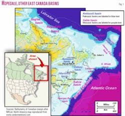
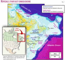
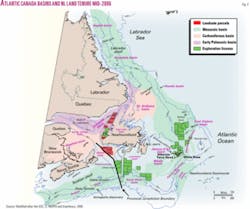
The passive continental margin of Atlantic Canada stretches on for more than 3,000 km from Georges Bank, at the Canada-US border to the northern tip of Labrador (Figs. 1 and 2) and off Baffin Island.1 2 6-8
With production of more than 338,000 b/d, representing around 10 million bbl/month, the province of Newfoundland and Labrador is producing at the level of a world class producer from one giant, Hibernia, and two large fields, Terra Nova and White Rose. This production represents about 40% of Canada’s light oil output and it is equivalent to about 40% of the present deepwater Gulf of Mexico production.
White Rose field began production in late 2005 and is expected to ramp up this summer to about 100,000 b/d, while the other two fields have reached their production peaks. These fields are in the increasingly productive Jeanne d’Arc basin, which is only one of the many Mesozoic basins located in Atlantic Canada.
Based on latest geologic, petrophysical, and reservoir simulation studies and drilling results, the C-NLOPB has revised upward its estimates of recoverable reserves-resources. It put Hibernia field oil reserves at 1.244 billion bbl, an increase of 379 million bbl, and the Hebron complex at 731 million bbl of proven and probable oil resources, an increase of 317 million bbl.
These amounts bring the total of oil reserves-resources in the Newfoundland and Labrador offshore area to 2.75 billion bbl, an increase of 696 million bbl from previous estimates. This combined reserve boost generously counterbalances the already produced oil from Hibernia and Terra Nova fields.
Newfoundland and Labrador’s area of petroleum potential extends far beyond the boundaries of the producing Jeanne d’Arc basin.6-8 Mesozoic sedimentary basins are found from the Laurentian basin, across the Grand Banks basins, through the deeper waters of the Flemish Pass basin, and into the Orphan basin, where activity is now focused, and continuing northward into several basins along the Labrador shelf and slope (Figs. 1 and 2).7 9-11
Also present are Paleozoic basins that occupy several large areas on land and the entire Gulf of St. Lawrence, off Newfoundland’s west coast.12 Recent petroleum land sales including the present 2006 Call for Bids (closing November 2006) have targeted both Mesozoic and Paleozoic basins, with major exploration programs ongoing in the East Orphan and Laurentian basins.6 7
The Labrador Mesozoic area (Fig. 2) is the most northerly of the Atlantic Canada basins, and it appears that the large 2D programs in the area are part of a reconnaissance phase that is likely to lead to a licensing round in the near future.
Regional geology
Favorable geology with proven large gas discovery but relatively remote location and harsh environment characterize the Labrador Sea.
The Hopedale basin is the southernmost rift basin within the Labrador Sea and is positioned just north of the Orphan basin, which is an area of current exploration drilling by Chevron, ExxonMobil, Imperial Oil, and Shell (Figs. 1 and 2). The basin has an elongated area of 175,000 sq km situated between 55° and 59° N. Lat. (same latitude as North Sea) and in 100 to 3,000 m of water.
The shelf part of the basin has water as deep as 400 m, was recently glaciated, and contains several banks, plateaus, and troughs. The slope is relatively gentle and less sculptured by canyons as compared to the Scotian shelf or Southern Grand Banks margins.
The Labrador Sea is an Atlantic-type extensional margin, initially part of the intracontinental network of basins formed during the Mesozoic between North America and North Africa and Europe.2 7 13-19
The region was subjected to rifting, continental mantle exhumation, drifting, seafloor spreading between Labrador and Greenland, oceanic rift cessation, ridge abandonment, and significant thermal subsidence.2 5 17 20-24
The prerift basement consists of Precambrian metamorphic and magmatic rocks and Paleozoic clastics and carbonates.12 25-28 The Mesozoic sedimentary fill contains faulted and slightly folded mostly Early Cretaceous synrift sedimentary rocks, all covered by a thick wedge of Tertiary and recent glacial deposits.
Geologically, the Hopedale rift basin is bounded:
- To the west by the onlap of Mesozoic beds into a prerift basement hinge zone or in places by a down-to-the-sea basin-bounding fault;
- To the south by the Cartwright Transfer Fault Zone (CTFZ) that separates it from the Cartwright arch and Hawke basin;
- To the east by the lineament marking the Continent-Ocean Boundary (COB) that is placed beyond the end of the seismic survey; and
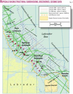
- To the north by Okak arch and an implied transfer zone separating it from the Saglek basin (Fig. 3).
Recent seismic exploration in the basin began in 2002 and includes more than 30,000 line km of speculative 2D seismic, predominantly acquired by Geophysical Services Inc. (GSI), Calgary. The original programs were more of a regional grid to define the major structural and stratigraphic elements of the basin, but each year GSI has returned to acquire denser coverage that is more suitable for identified leads and prospects. GSI has donated the data to Memorial University for regional geology studies and made the data available for illustrations in this article.
Exploration history
Over 40 years of petroleum exploration has unlocked the regional geology and unveiled some of the petroleum wealth of the sedimentary basins.
The shelf of the Hopedale basin was intensively explored in the 1970s-early 1980s when over 120,000 km of 2D seismic data was collected and all existing 21 industry wells within the basin were drilled.7 14 29-32 Several wells did not reach their petroleum targets and only 16 wells provide significant data in terms of basin analysis.
This earlier seismic and drilling information helped to identify the main stratigraphic units and structurally map the shelfal Late Mesozoic-Cenozoic basinal area that contains proven reservoirs and source rocks.29 30 33
The Geological Survey of Canada (GSC) provided a thorough portrayal of Labrador Sea basins based on interpretation of earlier seismic data in its monumental Labrador Atlas.14 The present study extends the Hopedale basin description into the deeper parts of the basin and to the outer shelf and slope area (up to 3,000 m of water) and helps evaluate its further petroleum potential
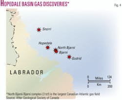
All five Labrador shelf gas discoveries have come from shallow targets in the Hopedale basin (Figs. 1 through 4). The first discovery, Bjarni H-81 in 1973, was followed by Gudrid H-55 (1974), Snorri J-90 (1975), Hopedale E-33 (1978), and North Bjarni F-06 (1980) (Figs. 3 and 4).2 4 13 29 30 32 These wells tested between 8 and 20 MMcfd.
The computed recoverable resources (P50) are for North Bjarni 2.2 tcf, Bjarni 0.9 tcf, Hopedale 0.1 tcf, Gudrid (0.9 tcf), and Snorri 0.1 tcf.3 7 31 34 No drilling has occurred in the basin since 1983.
The excellent quality reservoirs encountered at depths of 2 km to 3.5 km are Late Cretaceous sandstones of the synrift sequence and Paleozoic prerift limestone and dolomites.5 14 29 33 The discoveries have estimated total reserves of 4.2 tcf of gas and 123 million bbl of NGL of 50-60º API. The undiscovered gas potential in the Labrador shelf is estimated at 22 tcf.34
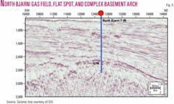
One complex formed by adjacent Bjarni and North Bjarni fields contains more gas than the currently producing Sable Project (Sable is composed of five medium size fields off Nova Scotia) or the large (2.7 tcf) White Rose gas cap in the Jeanne d’Arc basin (Figs. 3 to 5).
Umpleby defined the stratigraphic nomenclature of the Labrador shelf sequence.33 McWhae et al.29 redefined the basin stratigraphy using several new seismic stratigraphic units; GSC adapted his published chart, which was largely accepted by the exploration community.
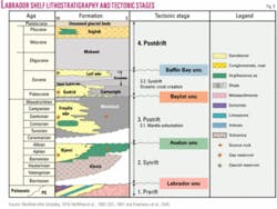
A lithostratigraphic chart modified from these authors and including tectonic evolution, source, and reservoir intervals and main unconformities marked by regional seismic markers is presented in Fig. 6. During the early exploration cycle, drilling targeted basement highs, drape anticlines, sand pinchouts, and several listric fault blocks. One well, North Leif I-05, has recovered small quantities of 33° API waxy oil from the Bjarni sandstone (Fig. 3).
It is worth mentioning that gas discoveries were recorded accidentally during the search for oil reservoirs. No systematic gas drilling, using DHI or AVO analysis of the seismic data, was ever performed in this area.
Geoscience data base
A large variety of industry and research reflection, refraction, gravity, magnetic, bathymetric, engineering, economic, environmental and well data has accumulated in the Labrador Sea and are available for consultation from the GSC, C-NLOPB, Government of Newfoundland and Labrador, Memorial University, and other sources.
Only the geoscience database is discussed here, and the reader can find more detailed information in the attached references.
Seismic data. The early seismic data base is extensive, comprising well over 100,000 km of data spanning over 15 years of seismic exploration and research in the Labrador Sea area. Most of the older data were collected only on the continental shelf and upper slope and are not migrated.
Several multichannel deep seismic lines were also acquired by research institutes in Canada and abroad.18 19 24 GSI and TGS recently recorded high quality long lines and made them available to the industry.
The GSI 2003-2004 Hopedale basin 2D seismic grid was donated to Memorial University for regional structural studies and investigation of its petroleum systems (Fig. 3). This data set was used in this study. The GSI dip lines cover the entire continental margin extending into the deep and ultradeep water.
A dozen basin-crossing strike lines were collected to tie most of the significant exploration wells and correlate regional markers. Evidently, this data grid contains better quality imaging than data collected 30-35 years ago, and it extends from the near shore to the lower slope of the basin, which is a very important factor in allowing the deciphering of the basins evolution, and in the identification of new play concepts.
Additionally, 20,000 km of older GSI lines have been reprocessed and added to the current grid.
Seismic data parameters. The 2003-04 GSI 2D seismic grid contains 10,121 line km. Acquisition was done with 6 to 8 km long streamers and recorded to a minimum of 12 sec. Processing to 10 sec includes modern multiple elimination routines and Kirchoff prestack time migration resulting in ninety-sixfold data with excellent to fair quality data (depending on geological complexity).
Data quality suffers on the shelf break and upper slope whenever a rough and-or hard water bottom is present. The regional dip grid is generally 30 km spaced and in places it gets denser to 20 and 10 km spacing. Dip lines are tied by very long strike lines that are denser on the shelf and 80 km apart on the slope.
A denser grid was recorded over North Bjarni and several other discoveries. During 2005, GSI more than doubled its Labrador Sea coverage and extended the work north into the Saglek basin using the same acquisition parameters and data processing sequence. The company plans more data acquisition (15,000 km) in the 2006 season.
Well data. A total of 21 wells were drilled in the Hopedale basin during the late 1970s-early 1980s; only 19 are classified as exploration and two are delineation wells (Bjarni O-82 and Herjolf M-92). Only 16 exploration wells reached the planned exploration target. Good electric and radioactive logs exist for most wells as well as good velocity information for seismic data correlation and depth conversion.
While several wells have encountered gas in Cretaceous and Tertiary reservoir sandstones as well as in Paleozoic carbonates, no Kimmeridgian source rock (the prolific source of Grand Banks) was penetrated, but source rocks with high TOC were drilled in Cretaceous and Lower Tertiary formations. Excellent cores through reservoir and source rock intervals are available from the C-NLOPB Core Repository.
Well history reports and various information (logs, check-shot surveys, tops, drillstem tests, etc.) are publicly available from Canada-Newfoundland Labrador Offshore Petroleum Board (C-NLOPB) and from the Geological Survey of Canada (GSC) Basin web site (www.gsca.nrcan.gc.ca/BASIN)
Potential field data. A compilation of marine magnetic and gravity data is available from GSC in both map and digital form.35 This dataset was used to correlate the tectonic and structural elements observed on the reflection data and estimate sediment thickness on the margin.24 25 36 Satellite gravity is also available in the public domain.
Potential field data provided by the GSC help to better estimate the composition of the numerous large rotated fault blocks and ridges that form the prerift basement and are covered by Early Cretaceous clastics and volcanics and draped by later sediments.5
Several authors20 21 23 37 discussed the magnetic data when trying to establish the seaward extension of continental and transitional crust and discuss the geodynamic evolution of the Labrador Sea.
Based on analysis of the potential field data integrated with reflection lines we can extend the area viable for oil and gas exploration farther into the deep water where we can interpret a thick, mainly Tertiary, sedimentary cover over large swaths of transitional crust, containing peridotite ridges disposed parallel to the Labrador coast.5 22 23
Next: A look at the Hopedale basin’s structural and tectonic evolution, petroleum system, and exploration potential.
The author
Michael E. Enachescu ([email protected]) is Husky Energy Senior Fellow in Exploration Geophysics at Memorial University of Newfoundland, St. John’s, and an advisor to Palo Alto Investors of California. He has been involved with major exploration drilling programs in the Grand Banks, Scotian shelf and slope, Labrador Sea, Arctic, and Beaufort Sea. He was a member of the regional mapping, discovery, and delineation teams and a contributor to the Development Plan Applications for Terra Nova and White Rose fields. He has worked in various basins in more than 20 countries.
