MADAGASCAR DEEPWATER-2 - How new seismic data show basin off western Madagascar
With the cooperation of Madagascar's OMNIS, TGS-Nopec and a consortium operated by Xpronet Inc. acquired a test seismic survey in late 2001. The program was designed to answer the following questions:
1.Can seismic data quality be improved with current acquisition and processing technology as compared with the quality of historic data?
2.Do the igneous sections, known from well control, blanket the west Morondava subsurface, or is there perhaps a limited distribution?
3.Can the origin of diapir-like structures seen in the legacy data be confirmed, whether evaporite/sedimentary (salt or shale) or igneous?
4.What can be determined about the structural and stratigraphic character of the large-scale deepwater bathymetric highs of the Davie ridge trend? Are these of interest for oil exploration?
While only 800 line km in cumulative length (four lines, Fig. 4), the new data base (88-fold seismic data with shipborne gravity and magnetic data) provides answers to each of these questions and suggests that the area is an early-stage province for future deepwater hydrocarbon exploration.
Acquired with a 6,600-m cable, the new reconnaissance data show substantial improvement in quality compared to the historic data. Apparent sedimentary rock sequences are visible down to 8 sec (two-way reflection time, as are subsequent references to seismic reflection time).
Survey interpretation
Seismic interpretation has been done in two steps:
1.Regional integration that included interval velocity, reflection strength, seismic depth displays, and shipborne gravity and magnetics profiles; and
2.Initial interpretation of amplitude seismic displays of structure, stratigraphy, and observed exploration leads.
The shallow-water ends of our survey lines all show the presence of magnetic bodies interpreted to result from the volcanic sequences present in the wells of Fig. 6. One other magnetic body is present in the southern end of the survey area and is interpreted as a shallow tabular igneous body, a possible intrusion.
The remaining data suggest that the area is relatively magnetically quiet, with only minor anomalies observed elsewhere. This is consistent with the character of the seismic data, from which we observe that the study area is underlain by a thick succession of sedimentary rocks.
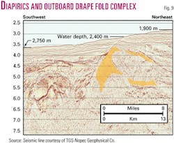
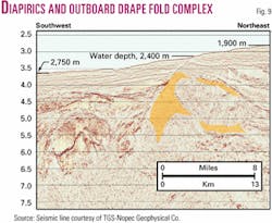
A major diapiric structure is evident in the center of the line shown in Fig. 9. This is interpreted as a salt structure due to its shape, seismic velocity, and internal seismic character. When restored to its predrift position (Figs. 7 and 8 in Coffin and Rabinowitz, 1988),7 this structure lies at similar latitude to the Mandawa-7 well in Tanzania, which penetrated a thick salt sequence.
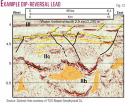
Fig. 1 is an extract from this same line, northeastward from Fig. 9, illustrating a dip reversal below 3.5 sec. A deep syncline lies between the southwest end of Fig. 1 and the northeast end of Fig. 9.
The section below the strong reflector at 3.7-3.8 sec is interpreted as upper Cretaceous in age, hypothesizing that this high-impedance event may be tied to the late Cretaceous bathymetric and depositional reorganization marking the end of the mid-to-late Cretaceous volcanic activity. The limited extent of the volcanic sequences observed in the nearest wells suggests that this region was on the western periphery of the igneous deposits associated with the separation of India from Madagascar.
The northernmost line extends from seaward of the Davie ridge eastward toward the shallow Madagascan shelf. The line crosses the broad gravity maximum, which we have interpreted as a failed oceanic rift (Fig. 8), and shows deep, apparent sedimentary reflections overlying a zone of high seismic velocity material. The sedimentary basin imaged on this line is on the order of 9.5-10 km thick below a 2-2.5 km thick water column.
While the late-Cretaceous volcanic rocks are thick in places (up to 2,094 m in Copetma Vaucluse-1, Fig. 6), our data suggest that these may be confined developments. The new seismic sections show that the volcanics do not uniformly blanket the west Morondava subsurface. Where present, they are distal, remnant accumulations, derived from sources far to the southeast.
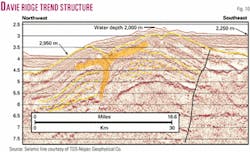
To the west, the Davie ridge trend of structures can be seen to consist of an outcropping cuesta on the western edge of this deep basin. These structures also illustrate internal diapiric seismic character as interpreted in Fig. 10.
The large fault interpreted in this section may be a strike-slip fault, recognizing that there is a significant character difference with the data to the east. This may be also consistent with our understanding of the wells of Fig. 6, where the lack of coherent thickness relationships across the faults, suggests apparent reversal of throw over time—and therefore strike-slip motion may be indicated.
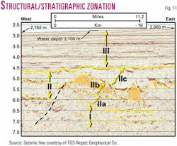
These regional lines show a clear structural and stratigraphic zonation in the basin fill. Three major zones are here identified, from bottom to top (Fig. 11). Zone I is the deepest and is characterized by parallel and subparallel reflections, with limited indications of block faulting. Zone I is readily differentiated with a set of deep, nearly horizontal seismic reflectors. Inspection of the data confirms these to be primary reflectors and not multiples.
Above this, Zone II is characterized by rapid changes in internal unit thicknesses. Zone II is in turn divided into three subunits IIa, IIb, and IIc.
Subunit IIa reflections are generally parallel and subparallel within the unit, but are often onlapping to the top of Zone I.
IIb is disrupted by diapiric character interpreted to be the result of salt movement, and colored orange on our displays. Zone IIb contains apparent salt welds that appear as strong amplitude layers. Our initially-processed displays of these reconnaissance lines used a 0.5-sec amplitude gain control (AGC) window, resulting in the appearance of strong low-frequency reflectors within relatively acoustically transparent sections.
When the acoustic gain between strong reflectors in subunit IIb is properly adjusted, the true nature of the geology becomes apparent. Similar AGC effects were first noticed in areas of the deepwater Gulf of Mexico where salt layers and salt welds are present.
The geometric form of the strong reflections seen within IIb are more consistent with salt contacts than with volcanic layers or igneous intrusions. The lack of magnetic signature argues against the presence of massive volumes of igneous material being present in this deepwater basin.
Subunit IIc sediments fill in around the diapiric structures of subunit IIb.
As a working hypothesis, the top of Zone II is currently interpreted to be within the upper Cretaceous. Our ties to the well control (Fig. 6) suggest that the top of the volcanic section is not of uniform age. A range in age from Maastrictian-Campanian to Coniacian-Turonian is possible, depending upon location.
The shallowest section, Zone III, is a continental rise sedimentary accumulation, latest Cretaceous to Recent in age.
Exploration implications
The TGS-Nopec reconnaissance test seismic data show potentially prospective diapiric (salt/shale) structures (Fig. 9), large dip-reversal structures (Figs. 1 and 12), and amplitude anomalies and flat-event anomalies (note arrows in Fig. 12) in the study area. Dip-reversals and structural complexes from 10 to 30 km in apparent width are present on three of the four lines of this reconnaissance program.
Our work suggests that the thinned continental crust/failed rift (Fig. 8) may be of late Carboniferous to Triassic age, during which intermittent graben formed, perhaps similar to parts of the onshore Morondava basin.7 14 Within our study area, this was succeeded by deposition of Jurassic-Cretaceous sediments, including local evaporites in the Jurassic, as shown schematically in Fig. 5.
The new seismic data (Fig. 10) shed fresh light on the origin of the Davie ridge structural trend, the shallowest expression of which should be viewed as a late Cretaceous and younger feature, a reactivated plate boundary, distinct from an older "Davie Fracture Zone." The Davie Fracture Zone is a feature implied from reconstruction of magnetic data, along which the Malagasy subplate drifted during mid-Jurassic through early Cretaceous time.
The Davie ridge trend of bathymetric highs appears to originate from post-tectonic adjustment along the western edge of the subplate during the early Tertiary. This younger movement had rather widespread effect, as evidenced by the early Tertiary unconformities seen even in the wells of Fig. 6 some 250-300 km to the east.
Exploration findings
Here are the key conclusions:
1.Confirmation of the presence of a widespread composite sedimentary basin extending the greater Morondava basin westward into deep waters nearly 300 km from the Madagascan coast.
2.Seismic imaging of as much as 9.5-10 km of sedimentary fill in a basin between the Davie ridge and the present day shelf break off the west coast of Madagascar.
3.Interpretive support for hypothesized salt tectonics and salt basins. After restoration to their predrift positions, these areas lie contiguous with recognized salt basins offshore from Tanzania and Kenya.
4.Observation of multiple types of potentially prospective structures:
Diapiric structures, cored by salt or shale, or both.
Dip-reversal structures on the order of 10-15 km in apparent width, and large composite structures up to 30 km across.
Amplitude anomalies (both positive and negative amplitude variation with offset) and anomalous flat-events.
5.Seismic evidence from which to infer hydrocarbon source kitchens of likely Triassic through Cretaceous age which would be capable of generating large-scale volumes of hydrocarbons, perhaps analogous to known deposits at Bemolanga and Tsimiroro.
6.Igneous sections appear to be limited in their distribution, concentrated inboard of the present day shelf break, but with probable dikes and sills scattered elsewhere, as indicated by drilling results, seismic and magnetic character.
7.Two lines crossed bathymetric highs of the Davie ridge trend, exhibiting post-upper Cretaceous anticlinal folds and cored with rocks of diapir-like character. Other lateral character changes in the seismic data suggest that there could be strike-slip faults bounding these anticlines, bringing rocks of differing time-space origin into juxtaposition. These same two lines also continue across the Malagasy subplate-Africa plate boundary, indicated by these data to lie westward and separated from the Davie ridge trend of bathymetric highs.
These observations confirm that the deep waters of the west Morondava basin contain structures of sufficient size and frequency to be the target of a continuing deepwater hydrocarbon exploration program. Additional geological and geophysical data need to be acquired, since, for example, there is no regular grid of seismic data, only a set of one-line crossings from which these initial structures of interest have been identified.
Acknowledgments
Office des Mines Nationales et des Industries Stratégiques (OMNIS), Antananarivo, Madagascar; Robert Bertagne and Donald Rusk, of Rusk, Bertagne & Associates for their cooperation and exchange of information as the projects advanced; William Pearson, Pearson Technologies Inc.; Thomas Wittick of Lindon Exploration; Nick Cameron and Ray Bate, Global Exploration Services (UK); and Xpronet Inc. The authors also thank the management of TGS-Nopec Geophysical Co. for use of the seismic data displayed herein.
The authors
Ralph A. Stone ([email protected]) is a consulting geoscientist to Xpronet Inc. and was vice-president, exploration from 1997 until July 2002. He has worked in oil and gas exploration and production for the past 32 years, beginning his career with Mobil Oil Corp. He has since held posts with Superior Oil, Kilroy Co., CLK Co., and Seagull Energy. He holds BS and MS degrees in geology from Wheaton College and the University of Wisconsin-Madison, respectively.
Samuel D. LeRoy ([email protected]) is vice-president of EarthView Associates Inc., Houston. For the past 10 years he has consulted on building exploration frameworks for frontier basins and applying new technologies in mature petroleum provinces. Recent projects include combining seismic, gravity and magnetic data sets to explore continental margin basins and exploring in geopressured environments using velocity fields with AVO-AVA-AVF. He has over 25 years' industry experience, working previously for Texaco and Conoco. He holds a PhD in geology from the University of Southern California.
References
1. Radelli, L., "Geology and oil of Sakamena basin, Malagasy Republic (Madagascar)," AAPG Bull., Vol. 59, No. 1, 1975, pp. 97-114.
2. Kamen-Kaye, M., "Mozambique-Madagascar geosyncline (Part 1): Deposition and architecture," Jour. of Petroleum Geol., Vol. 5, No. 1, 1982, pp. 3-30.
3. Kamen-Kaye, M., "Mozambique-Madagascar geosyncline (Part 2): Petroleum geology," Jour. of Petroleum Geol., Vol. 5, No. 3, 1983, pp. 287-308.
4. Du Toit, S.R., Kidston, A.G., and Slind, O.L., on behalf of the Canadian International Development Agency, "Hydrocarbon Potential of the East Africa Continental Margin," Alconsult International Ltd., Calgary, 1997, 132 p., 2 tables, 45 figs., 35 encl.
5. Rayer, F.G., and Slind, O.L., "Hydrocarbon potential of the East Africa continental margin," Offshore, Vol. 59, 1999, pp.107-112.
6. Coffin, M.F., and Rabinowitz, P.D., "Reconstruction of Madagascar and Africa: Evidence from the Davie Fracture Zone and Western Somali Basin," Jour. Geophysical Res., Vol. 92, No. B9, 1987, pp. 9,385-9,406.
7. Coffin, M.F., and Rabinowitz, P.D., "Evolution of the conjugate East African-Madagascan margins and the western Somali Basin," GSA Spec. Paper 226, 1988, 78 p.
8. Coffin, M.F., and Rabinowitz, P.D., "The Mesozoic East African and Madagascan conjugate continental margins: stratigraphy and tectonics," in, Watkins, J.S., Zhiqiang, F., and McMillen, K.J., "Geology and Geophysics of Continental Margins," AAPG Memoir 53, 1992, pp. 207-240.
9. Lawver, L.A., Gahagan, L.M., and Dalziel, I.W.D., "A tight fit early Mesozoic Gondwana, a plate reconstruction perspective," in Motoyoshi, Y., and Shiraishi, K., eds., "Origin and Evolution of Continents," proceedings of the "Origin and Evolution of Continents" international symposium, Oct. 13-14, 1997, Tokyo, Memoirs of National Institute of Polar Research, Special Issue No. 53, pp. 214-229, 1999. Accessible from: http://www.ig.utexas.edu/people/staff/lawver/gondwana/gondwana .pdf
10. Rusk, D., and Bertagne, R., "Petroleum geology and geophysics of the Mozambique Channel," announcement, Rusk, Bertagne & Associates and TGS-Nopec Geophysical Co., 2002, 7 p., 5 figs.
11. Storey, Michael, Mahoney, John J., Saunders, Andrew D., Duncan, Robert A., Kelley, Simon P., and Coffin, Millard F., "Timing of hot spot-related volcanism and the breakup of Madagascar and India," Science, Vol. 267, Feb. 10, 1995, pp. 852-855.
12. Torsvik, T.H., Tucker, R.D., Ashwal, L.D., Eide, E.A., Rakotosolofo, N.A., and de Wit, M.J., "Late Cretaceous magmatism in Madagascar: palaeomagnetic evidence for a stationary Marion hotspot," Earth Planet. Sci. Lett., Vol. 164, 1998, pp. 221-232.
13. Torsvik, T.H., Tucker, R.D., Ashwal, L.D., Carter, L.M., Jamtveit, B., Vidyadharan, K.T., and Venkataramana, P., "Late Cretaceous India-Madagascar fit and timing of break-up related magmatism," Terra Nova, Vol.12, No. 5, 2000, pp.220-225.
14. Nichols, G.J., and Daly, M.C., "Sedimentation in an intracratonic extensional basin: the Karoo of the central Morondava basin, Madagascar," Geol. Mag., Vol. 126, No. 4, 1989, pp. 339-354.
Bibliography
Besairie, H., and Collignon, M., "G
Besairie, H., "Carte geologique de Madagascar," Service G
Bassias, Y., and Leclaire, L., "The Davie Ridge in the Mozambique Channel: crystalline basement and intraplate magmatism," N. Jb. Geol. Pal
Boast, J., and Nairn, A.E.M., "An outline of the geology of Madagascar," in Nairn, A.E.M., and Stehli, F.G., eds., "The Ocean Basins and Margins: The Indian Ocean," Plenum, New York, 1982, pp. 649-696.
Clark, David N., "Review of the exploration potential of Madagascar," Houston Geol. Soc. Bull., June 1998, pp. 23-29.
Demaison, G.J., "Tar sands and supergiant oil fields," AAPG Bull., Vol. 61, No. 11, 1977, pp. 1,950-61.
Dostal, J., Dupuy, C., Nicollet, C., and Cantagrel, J.M., "Geochemistry and petrogenesis of Upper Cretaceous basaltic rocks from southern Malagasy," Chemical Geol., Vol. 97, 1992, pp. 199-218.
Droz, L., and Mougenot, D., "Mozambique upper fan origin of depositional units," AAPG Bull., Vol. 71, No. 11, 1987, pp.1,355-65.
Lalaharisaina, J.V., and Ferrand, N.J., "Cretaceous may hold promise in Majunga basin," Madagascar, OGJ, Aug. 1, 1994, pp. 54-58.
Lort, J., Limond, W., Segoufin, J., Patriat, P., Delteil, J., and Damotte, B., "New seismic data in the Mozambique Channel," Mar. Geophys. Res., Vol. 4, 1979, pp. 71-81.
Pawlowski, R.S., Meaux, D.P., and von den Steinen, A., "East Africa study highlights regional framework using geoscience syntheses," Offshore, Vol. 61, 2001, pp. 90-100.
Storey, Michael, Mahoney, John J., and Saunders, Andrew D., "Cretaceous basalts in Madagascar and the transition between plume and continental lithosphere mantle sources," in Mahoney, J.J., and Coffin, M.F., eds., "Large Igneous Provinces: Continental, Oceanic, and Planetary Flood Volcanism," Geophysical Monograph 100, American Geophysical Union, Washington, DC, 1997, pp. 95-122.
