Diagenetic Reservoirs —1: Systematic exploration approach for diagenetic traps advanced
Recent hydrocarbon discoveries in diagenetic reservoirs, particularly in New York state and western Canada, have focused attention on these underexplored types of fields.
Traditionally hydrocarbon exploration has focused on structural and stratigraphic traps, and until recently accumulations associated with diagenetic traps largely have been found by accident. An improved understanding of the role of basinal hydrothermal fluids in forming diagenetic traps now facilitates deliberate exploration for them but requires a new exploration strategy.
Basinal hydrothermal systems affect the 1) development of secondary porosity and cements in siliciclastic units, 2) dolomitization and solution of carbonates, and 3) regional and local maturation of hydrocarbon source units. Hot brines of these systems move laterally via deep regional aquifers toward the basin margins.
Diagenetic traps develop where hydrothermal flow is focused and vertically directed. Regionally, vertical flow is most likely on arches and at regional aquifer or seal terminations. On an oil field scale, reactivated basement-involved faults, fault intersections, and karst features further focus vertical flow.
The first step in the systematic exploration for these types of accumulations is the regional mapping of deep aquifers, seals, and basinal architecture to identify key zones of lateral flow and vertical flow of basinal brines. In mature basins this analysis can be carried out using published literature and low-cost well logs.
Within the areas identified as generally favorable for vertical fluid flow, emphasis should be placed on identifying reactivated basement faults and fault intersections using public domain maps and low-cost gravity and magnetic data. In these highgraded areas, seismic data are effective at identifying subtle sags and dim-out zones related to solution and diagenesis in horizons favorable for development of diagenetic reservoirs.
Basinal brine migration
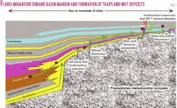
Understanding the regional and local movement of basinal brines is essential to systematically explore for diagenetic traps formed by these fluids (Fig. 1).
Driven by a variety of mechanisms, basinal brines move laterally toward the basin margins via deep aquifers. In many of the Paleozoic basins of North America, the basal sandstone produced by the Cambrian transgression is one such deep aquifer. Typically in these Paleozoic basins, the Cambrian sandstone is directly overlain by a carbonate unit of regional extent.
Through infiltration of hot brines from the underlying sandstone, the overlying carbonate unit can be pervasively dolomitized and develop permeable zones that form additional regionally extensive aquifers. Examples of this relationship include the lower Ordovician units in the central and eastern US (Knox, Arbuckle, Ellenburger) and various Middle Devonian units in the Western Canada basin.1
In some parts of these aquifers, permeability and porosity are increased by dissolution of feldspars and unstable rock fragments in sandstones and by dolomitization and solution of calcium carbonate in limestone units. In other parts of the aquifers, porosity and permeability are decreased by precipitation of quartz, clay, and carbonate cements derived from the dissolved components. These effects are predictable and mappable based upon thermal, structural, and stratigraphic constraints.
In zones of focused vertical flow, hydrothermal brines produce reservoirs of restricted areal extent by dolomitization, solution of carbonates, silicification, and brecciation (Fig. 1). Until recently, these diagenetic traps largely have been found by accident during exploration for structural and stratigraphic traps. Diagenetic traps offer new opportunities in many basins at a mature level of exploration for “conventional” hydrocarbon traps, and an improved understanding of their origins now facilitates deliberate exploration for them.
Controls on trap formation
In the following sections, known examples of diagenetic reservoirs and Mississippi Valley Type (MVT) lead-zinc deposits are used to illustrate the structural and stratigraphic controls on diagenetic trap formation.
MVT deposits are low-temperature hydrothermal deposits that occur in carbonate units located in cratonic or foreland basins. While there are obvious differences between MVT deposits and hydrocarbon accumulations hosted in diagenetically developed reservoirs, the similarities in character and origin far exceed their differences.
Both are characterized by dolomitization, silicification, and carbonate solution produced by low temperature basinal hydrothermal fluids. MVT deposits contain metal sulfides and minor amounts of hydrocarbons, while the diagenetic reservoirs contain hydrocarbons and minor MVT type sulfide minerals.
Recognition of MVT deposits/alteration as part of a continuum with diagenetic hydrocarbon traps allows application of the voluminous three-dimensional structural, mineralogic, geochemical, isotopic, and fluid inclusion data and resultant concepts developed from the MVT deposit exploration, mining, and research to be applied to hydrocarbon accumulations.
Fluid inclusion and mineralogy data from MVT lead-zinc deposits, stable isotope data from reservoir cements, basinal brine compositional data, and patterns of alteration demonstrate that much of diagenesis within sedimentary basins is produced by lateral and local vertical migration of hot, basinal brines.1-8
Most large structural or stratigraphic hydrocarbon accumulations are reservoired in regional aquifer units. These “conventional” hydrocarbon traps have been the focus of extensive exploration and have been extensively exploited in basins at a mature level of exploration.
In this article, regional aquifers are considered only in the context of their role in the lateral transport of hot brines from basin centers toward the basin margins where the brines may form “unconventional” reservoirs that rely partly or wholly on diagenetic changes for hydrocarbon trapping.
Diagenetic trap formation occurs in areas of focused vertical migration and is controlled by a combination of structure, original depositional fabric of the reservoir, and subsequent diagenesis. In areas of focused vertical flow, dissolution and brecciation associated with volume change are common, and diagenesis includes dolomitization, silicification, dedolomitization, and precipitation of calcite, siderite, sulfides, and sulfates.
This alteration is restricted to the flow conduit and adjacent strata. The extent of diagenesis depends on the original matrix and fracture permeability of the reservoir rock.
During periods of strong lateral fluid flow, basinal brines move through regional aquifers toward the margins of basins and toward fluid outflow zones such as regional arches.4 5

In these regions enhanced vertical flow occurs where 1) major aquifers terminate and lateral fluid flow is restricted, 2) aquifuges or aquicludes that act as seals locally are absent, or 3) seals are breached by major faults. Structures that enhance and focus vertical flow of basinal brines can be arranged hierarchically by scale from regional arches to individual fractures (Table 1).
In most cases several scales of structures are involved in localizing and focusing vertical fluid flow. In the following sections, features that focus vertical flow of hot basinal brines are described proceeding from large-scale to oilfield-scale using examples from both oil fields and MVT deposits as exhumed oil fields.
Findlay arch
The Middle Ordovician Trenton formation of northwestern Ohio provides an example of major hydrocarbon accumulations reservoired in dolomite formed by hydrothermal brines localized by a regional arch.
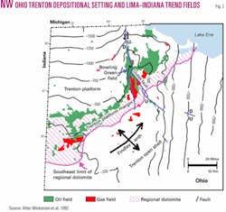
In this area the Findlay arch plunges in a north-northeasterly direction (Fig. 2). Depositional settings in the Trenton trend in a more easterly direction than the arch and from northwest to southeast consist of carbonate platform, platform margin, and open shelf.9
Major historic oil and gas fields of the Lima-Indiana trend are located along the southeastern margin of the carbonate platform, which largely lies along the northern flank of the arch. The estimated historic production from this trend in Ohio and adjacent Indiana is 500 million bbl of oil and 1 tcf of gas.9
Across much of Ohio, the Trenton formation is an impermeable limestone, but in northwestern Ohio coarsely crystalline hydrothermal dolomite and zones of brecciation and solution with associated minor MVT mineralization occur in Bowling Green field, which is located along the Bowling Green fault slightly north of the main Lima-Indiana trend. Fine- to coarse-grained dolomite with fair porosity but relatively low permeability is the reservoir in the main Lima-Indiana trend.9
The relationship between these two dolomites is not fully documented, but the following scenario is proposed as a working hypothesis. The structure on the top of the Precambrian basement forms a large closed high beneath the Findlay arch and centered just south of the southern extent of the Bowling Green fault (Fig. 2).10 The structure of the overlying Cambrian Mount Simon sandstone, which is the main deep aquifer of the region and likely source of the dolomitizing fluids, approximately mimics the top of the Precambrian.
This relationship suggests that hot basinal brines moved laterally through the Mount Simon sandstone from the Michigan basin toward the Findlay arch and then moved vertically up the Bowling Green fault zone. Finally the brines spread out laterally along the updip margin of the Trenton platform through packstones and grainstones that had some preexisting permeability to produce the regional dolomites developed along the Lima-Indiana trend.
Oils from these fields have a general geochemical signature linking them to Ordovician source rocks,11 but a precise oil-source rock correlation has not been made. Burial history plots indicate that Ordovician source rocks generated oil during the Carboniferous in the Michigan basin12 and during the Permian and Triassic in northwestern Ohio.13 These periods coincide with the Permian or Pennsylvanian period of fluid flow suggested by reset K-Ar dates from Ordovician bentonite beds in the southern Michigan basin, along the Cincinnati arch, and in central Indiana.14 and suggest that migration of basinal brines and oil occurred at approximately the same time.
Aquifer truncation
The same Ordovician petroleum system present in northwestern Ohio extends into southwestern Ontario.
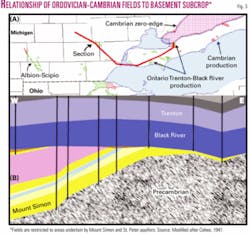
Several oil fields are hosted in hydrothermal dolomite reservoirs localized by minor faulting within the Trenton and underlying Black River formation15 (Fig. 3). However, the regional distribution of these fields is controlled by the position of the Algonquin arch and a regional angular unconformity at the base of the Black River formation that truncates the Mount Simon sandstone and Middle Ordovician St. Peter sandstone.16
Oil fields are restricted to the portion of the arch underlain by the two aquifers that transported basinal brines. No commercial fields have been found where the aquifers are eroded and Precambrian crystalline rocks subcrop directly beneath the Black River formation.15
Intersecting faults
Both basinal brines and hydrocarbons move laterally updip through aquifers. If a favorable geometry is present at the updip termination of the aquifer, hydrocarbons may be trapped stratigraphically (Fig. 4).
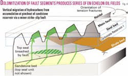
At these aquifer terminations, flow of both basinal brines and hydrocarbons also may become focused by migration through faults that cut the aquifer. Depending on the distribution of shallower aquifers and seals, these fluids may 1) migrate laterally along the fault zone and escape the system, 2) migrate laterally and vertically along the fault zone into the next highest aquifer or 3) migrate vertically up the fault zone.
In the latter case, hot basinal brines may form a diagenetic reservoir along the fault zone if a favorable carbonate unit and overlying seal are present. If the fault has a small component of strike-slip displacement, the likelihood of trapping is generally enhanced since this situation results in en echelon faults with limited lateral extent preventing escape of the hydrocarbons.17
Faults with large dip-slip displacements may allow brines to escape vertically without “ponding” to form a substantial diagenetic reservoir or may breach top seals preventing hydrocarbon trapping.
Top seal windows
Basinal brines and hydrocarbons migrate upward from regional aquifers in areas where regional top seals above the aquifer are absent due to nondeposition, erosion, or facies changes.
These windows may be either locally restricted or of regional extent. Smaller-scale features including faults, fractures, and karst features further control the local vertical migration of fluids in these zones.
Tri-State accumulations
The ore deposits of the Tri-State MVT district of southwestern Missouri, southeastern Kansas, and northeastern Oklahoma produced very large amounts of zinc and lead during the late 19th century and first half of the 20th century and contained enough oil and natural gas to be a hindrance to mining.
Regional patterns of mineralization and dolomite cement formation show that the mineralizing system was basin-scale and that the hydrothermal fluids migrated generally northward from the Arkoma basin as far north as central Missouri in aquifers in the Arbuckle Group and underlying Cambrian Reagan (Lamotte) sandstone.18
While trace amounts of mineralization occur over this very large area, the commercial ore deposits are restricted to Mississippian carbonate rocks located above a stratigraphic window formed by erosion of the Upper Devonian Chattanooga shale and nondeposition of the Mississippian Boice (Hannibal) shale.
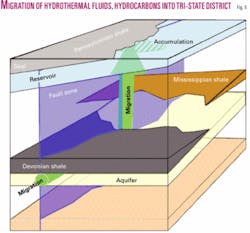
The absence of these shales that regionally form top seals for the Lower Paleozoic aquifers allowed ore fluids to move vertically into the Mississippian strata of the Tri-State area (Fig. 5). Shales of the Pennsylvanian Cherokee Group form a top seal above the mineralized carbonates.
Within the area of the stratigraphic window, regional and local faulting and gentle folding influenced district- and mine-scale alteration and mineralization.19 Alteration consisted of dolomitization and silicification of favorable limestone horizons.
Much of the silicified rock is stained brown or black by bitumen indicating migration of oil contemporaneously with alteration. The small quantities of oil and natural gas were reservoired in structural traps, generally anticlines, beneath a shale top seal.20
SE Michigan Trenton
While the role of stratigraphic windows through regional seals in controlling the formation of shallower diagenetic oil reservoirs is not well demonstrated, Albion-Scipio and Stoney Point fields of southeastern Michigan may be examples of this phenomenon (Fig. 6).
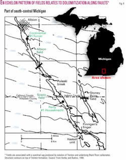
These fields are extremely long, narrow fields reservoired in hydrothermal dolomite formed in the Trenton and Black River formations along en echelon basement-involved faults reactivated during the Paleozoic with very minor strike-slip displacement and vertical displacement below the resolution of seismic.12 Dolomitizing brines are interpreted to have migrated vertically up the faults, probably from the Cambrian Mount Simon sandstone aquifer.
The only regional seal between the Black River formation and the Mount Simon is the Lower Ordovician Glenwood shale. In the area of the fields, the shale is abnormally thin (only about 6 ft or 2 m thick) due to the combined effects of depositional thinning and an unconformity at the top of the unit.12 Thus, only very small vertical fault displacement was required to breach the top seal formed by the Glenwood shale.
Elsewhere in the Michigan basin similar faults were not pathways for basinal brines perhaps because fault displacement was insufficient to offset a thicker Glenwood shale seal.
Next: Suggestions for a systematic approach to exploring for diagenetic reservoirs. ✦
The authors
Robert G. Hickman ([email protected]), owner of Structural Solutions, Houston, is a consultant specializing in structural and tectonic studies. He spent 25 years with Unocal, most recently as coordinator of structural geology. He has a BS in geology from Stanford University and an MS and PhD in geology from the University of Wisconsin.
W. Norman Kent ([email protected]) carries out international consulting through Kent GeoScience, Richmond, Tex. He spent 25 years at Unocal, where he participated in or managed exploration projects in the US and internationally. He has a BS in geology from the University of Arizona and an MS in geology from Northern Arizona University.