Dominican Republic seeks domestic gas resource
Stephen Pierce
Independent Consultant
Palmer, Tex.
Rigorous development activities point to a large accumulation of gas reserves in the Dominican Republic's Enriquillo basin on the island of Hispaniola.
Maleno Oil Co.'s ongoing exploration plans for two culminations of the Boca Cachon anticline in the southwest portion of the Dominican Republic and the government's cooperation may soon help the country achieve domestic production.
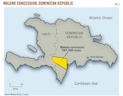
The Maleno concession consists of 597,000 acres. The company is deploying an exploration program involving geologic mapping, gravimetric, seismic, and geochemical surveys, and the drilling of a well.
The company operates two concessions in the Dominican Republic including Murfin and Maleno, formerly known as the Enriquillo (Fig. 1). Interest in hydrocarbon exploration in the Dominican Republic is based on oil seeps in the Azua basin (OGJ, Mar. 25, 2002, p. 40) and gas seeps in the western portion of the Enriquillo basin.
Because the Dominican Republic depends entirely on imports, the government encourages oil and gas exploration and cooperates in finding these resources.
Exploration history
Following extensive field work, Seaboard Dominican Oil Co. drilled the first well in the basin, the Mella–1, to a depth of 8,769 ft in 1946.1 Drilling activity lapsed until Petrolera Dominicana drilled the Palo Alto–1 to 6,568 ft in 1960, the Mella–2 to 10,910 ft in 1961, and the Cabritos–1 to 6,402 ft also in 1961.2 3
In 1981, Superior Oil Co. drilled the deepest well on the island of Hispaniola to 15,847 ft. The Charco Largo–1 was intended to provide oil for Superior's nickel mine at Falconbridge in the Cordillera Central.4 Before 2001, all of the previous wells in the basin were dry holes (Table 1).
In 2001, after evaluating existing gravity data, Maleno acquired about 10 miles of new seismic data. Combining these with previously acquired Superior seismic data and sampling the gas seeps adjacent to the Boca Cachon anticline, Maleno drilled the Boca Cachon–1 and discovered gas. However, the well was located too far down–dip on the anticline's eastern flank to be productive.
Geological structure
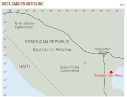
The Boca Cachon is a large, east–west trending anticline located in the western Enriquillo basin. It features two major culminations—Gran Sabana to the west and Sierra Preita to the east (Fig. 2).
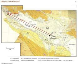
The basin's extension into Haiti is known as the Cul de Sac basin and also trends east–west. When combined, the basins have a total length of 124 miles. The Enriquillo basin is 62 miles long and varies in width from 10 to 25 miles in an eastward direction (Fig. 3).
Structurally, the Enriquillo basin is a ramp basin with its northern and southern flanks defined by reverse faults.6 The basin surface is generally covered by recent alluvial deposits. Early Pliocene evaporites of the Angostura formation and clastics of the Late Pliocene Sal Salinas formation crop out on the southern flank of the basin.
The stratigraphy of the Enriquillo basin consists of carbonates, clastics, and evaporites (Fig. 3). The basin's known sediments range in age from Middle Miocene Sombrerito limestone to recent. Although not observed within the basin, the oldest sediments are thought to be Paleocene to Eocene cherty carbonates that are observed on the north flanks of Neiba Sierra and Sierra de Bahoruco located on the south flank of the basin. In addition, basement consisting of Upper Cretaceous oceanic basalts outcrop in these mountains.
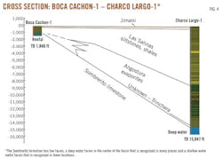
Well data show the observed sedimentary section within the center of the basin consists of Middle Miocene deep marine carbonates, Late Miocene deep marine Trinchera formation clastics, Early Pliocene evaporites, Upper Pliocene siltstones, shales and sandstones, and recent alluvium. On the western part of the basin at Boca Cachon, the recent is represented by reefal limestones of the Jimani formation. Fig. 4 shows a cross–section from the Boca Cachon–1 to the Charco Largo–1.
The Boca Cachon–1 is near the eastern margin of a Middle Miocene shallow carbonate platform. Lower to Upper Pliocene Angostura and Las Salinas formations conformably overlie the carbonate platform of Sombrerito reefal limestones (Fig. 4).
Fig. 5 illustrates the details of the stratigraphy of the Boca Cachon–1. Recent Jimani formation reefal limestones are represented by a 140–ft thick crop out at the surface. Directly below the Jimani formation are the Las Salinas and Angostura formations
Paleontology data are not precise enough to distinguish the Late Pliocene Las Salinas formation from the Lower Pliocene Angostura formation. The combined thickness of the silty Las Salinas and Angostura is 1,295 ft, and the Sombrerito formation lies conformably below. The Sombrerito is a reefal limestone with the upper part of the formation consisting of limestone and shale. The Boca Cachon–1 reached a total depth of 1,846 ft. within the upper Sombrerito limestone.
The petroleum system of the Boca Cachon features two large anticlinal traps. The Sierra Preita trap on the eastern culmination has an areal closure to the gas–water contact of 1,900 acres. The Gran Sabana culmination to the west of the Sierra Preita has not been mapped.
The Sombrerito reefal carbonates have 123 ft of net pay as recorded in the Boca Cachon–1. Silts and shales of the Las Salinas–Angostura formations provide adequate seals. The source rocks have not been identified, although they are located in the clastic–evaporitic sedimentary deposits of the eastern Lake Enriquillo.
Hydrocarbon potential
Four gas seeps were first identified in the western Enriquillo basin in 1942, and four additional gas seeps were discovered by in 1953.7
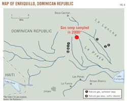
These gas seeps were drafted in 1947 (Fig. 6). Nelson described these seeps as emitting flammable gas bubbling from saltwater seeps, which were accompanied by faint odors of sulfurous gas.7
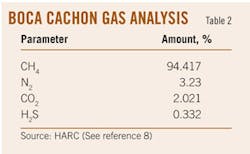
In November 2000, the Houston Advanced Research Council (HARC) analyzed gas samples captured from one of these seeps (Fig. 6). The analysis determined the gas contained hydrocarbon content no higher than that of methane (Table 2).
The methane was isotopically very light (–71 parts per trillion) with respect to Carbon–13, which suggests that the gas was of a biogenic origin. The laboratory observed a deuterium isotope ratio of –156 parts per trillion, which corroborates the C–13 data indicating a biogenic source.
Boca Cachon prospect
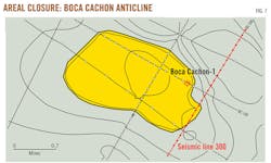
Efforts are under way to develop the gas potential on the two culminations of the Boca Cachon structure. The anticline is defined by surface geology, gravity, and seismic data. Seismic data consist of 21 miles of vibroseis data (from a total of 562 miles acquired in 1979 throughout the basin) and 10 miles of dynamite seismic acquired in 2001. Fig. 7 shows seismic control over the anticline.
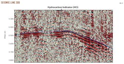
The Seirra Preita culmination is a gentle west–northwest, east–southeast anticline. The time structure map shows the Boca Cachon's Sombrerito formation with electric logs defining the gas–water contact. The hydrocarbon indicator (HCI) on Seismic Line 300 (marked in red) shows the gas migration into the reservoirs of the Boca Cachon anticline (Fig. 7).
Unfortunately, two of the three seismic lines acquired by Murfin drilling in 2001 were of poor quality due to seismic reflections above a hard carbonate surface, which is always a difficult task where hard lithologies are at the surface, such as limestones. Seismic line 300 clearly shows the tuning effect in the reflector at 0.488 sec (Fig. 8). The "sag" beneath is the effect of gas on the seismic velocity.
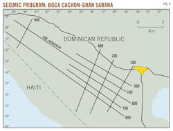
The Boca Cachon–1 well location was chosen with the poor seismic data along with the one good line.9 Maleno plans to acquire additional seismic data to exploit the potentially large gas reserves in the Boca Cachon anticline. The seismic program will cover not only the culmination at Sierra Preita, but also will include one additional line and the extension of two other lines to include the Gran Sabana structure (Fig. 9).
Acknowledgments
In addition to HARC's gas analysis, ASC Laboratories of Houston analyzed the water accompanying these samples.
References
1. Boardman, R., Internal report, Mella–1, Enriquillo basin, Dominican Republic, Seaboard Petroleum Co., 1946.
2. Ford, D., Interoffice correspondence, Paleontology report of Petrolera Dominicana Palo Alto–1, Superior Oil Co., 1978.
3. Author unknown, Well summary, Mella–2 Baoruco Province, Dominican Republic, Unpublished report, Petrolera Dominicana C. Por A., 1961.
4. Pierce, S., Well completion report Charco Largo–1, Superior Oil Co., 1981.
5 Toloczyke, M., Ramirez, I, Mapa Geologico de la Republica Dominiana, Secretaria de Estado de Industria y Comercio, Dominican Republic, 1991.
6. Mann, P., Draper, G., and Lewis, L., "Geologic and Tectonic Development of the North America–Caribbean Plate Boundary in Hispaniola," GSA Special Paper 262, 1991.
7. Nelson, P., A Report of Oil Prospects in the Dominican Republic, Western Natural Gas Co., 1954.
8. Elrod, L., unpublished report, HARC Geochemistry Laboratory, Houston, 2000.
9. Pierce, S., Well Completion Report Boca Cachon–1, Murfin Drilling Co., 2001.
The author
Stephen Pierce ([email protected]) is a consulting geologist with more than 37 years of international and domestic geologic exploration experience. He has provided prospects in the Dominican Republic to major and smaller independent oil companies and recently presented two papers at the Nineteenth Geologic Congress in Santo Domingo. He holds a BS in geology from Long Beach State University and an MS in geology from San Diego State University.

