CHINA THRUST BELT EXPLORATION-1: Oil discovery revives China foreland basin after long lull
Located in the northern edge of the Qilian Mountain fold belt in western China, the Jiuxi basin is a Mesozoic-Cenozoic foreland basin with Lower Cretaceous source rocks and Tertiary-Cretaceous reservoirs.
This is the first of two parts on the course of exploration and a relatively recent discovery that has implications for broader exploration in foreland basins and thrust belts elsewhere.
The Jiuxi basin is small but has 67 years of exploration history.
Five Tertiary anticline oil fields had been found in the foreland thrust belt at the southern margin of the basin with oil in place of 61.61 million tons from 1950 to 1960 and a peak production of 1.4 million tons in 1959. Since then, no discoveries were been made until the late 1990s, and production gradually declined to 0.4 million to 0.6 million tons/year.
In 1983, exploration turned to the source depression, i.e. the Qingxi Depression, and oil discovery peaked in the Jiuxi basin. In 1998 a high oil flow from the Lower Cretaceous was encountered in test well Liu 102 in the Liugouzhuang structure; and Qingxi field, the largest in the basin, was found. Since the discovery, 41 wells have been drilled, proved reserves have reached 58 million tons, and the basin’s production is 80 million tons/year.
The discovery of Qingxi field in the Jiuxi basin is an example of successful exploration in foreland thrust belts. The key factors for the success include deepened geological understanding, improved seismic imaging in hilly areas, better identification of reservoirs, and good reservoir stimulation. This success provides hope for finding new oil and gas fields in other foreland basins, especially their thrust belts, in central and western China.
The case study of the Qingxi field discovery in this article sheds light on future hydrocarbon exploration in thrust belts of foreland basins in China and other parts of the world.
Introduction
Foreland basins and their thrust belts are some of the world’s most petroliferous areas with a great hydrocarbon exploration potential.1
Mann and Gahagan2 classified six kinds of tectonic settings according to the evolution history of hydrocarbons and found that, among 595 giant oil and gas fields with reserves over 500 million bbl or equivalent gas, 141 are in collisional margins produced by terminal collision between two continents, and 44 are in collisional margins produced by overthrusting of volcanic arcs onto a passive margin. Pettingill3 showed that 58% of 76 giant fields discovered in 1990-99 are in collisional tectonic settings, including fold belts, foreland, and foredeep.
The multiple stages of tectonic evolution and multiple successions of source rocks in foreland basins are the principal geological factors for abundant hydrocarbon resources. The application of modern technology is critical to making a great discovery. For example, a suite of new and-or improved technologies in seismic data acquisition, processing, and interpretation, drilling and well completion, and stimulation of low permeability reservoirs, made the Greater Rocky Mountain Region the “garden” for exploiting previous big discoveries in the 1990s.4 Improved seismic technology, especially deep seismic imaging, plays a great part in big discoveries.
Petroleum exploration in foreland basins and their overthrust and fold belts in west and central China has a long history.5 During the 1950s and 1960s, exploration focused on clearly identified surface anticlines in foothills and depressions with many surface oil leakages, and many small and medium-sized oil fields were discovered.
In the 1990s, improved hilly seismic technology and drilling and well-logging technology under complex geological conditions (e.g., complex structures and high temperature and abnormal formation pressure) enabled discovery of a group of oil and gas fields in foreland regions, which increased reserves dramatically.
In the late 1990s, Qingxi field was discovered after 67 years of exploration in the mature Jiuxi basin. It is a great example of successful exploration in Chinese foreland basins and shows the great potential of hydrocarbon discoveries in many other thrust belts in west and central China. The success also demonstrates that good geological understanding and wise application of new technology can make great discoveries in mature foreland regions.
Basin evolution and petroleum system
Tectonics
The Jiuxi basin is located in the Hexi Corridor, northwestern China, bounded by the Alashan landmass in the north, Qilian Mountains in the south, Jiayuguan uplift in the east, and Arkin strike-slip fault belt in the west (Fig. 1).6
It is one of the Mesozoic-Cenozoic foreland basins along northern front of the Qilian Mountains and covers 2,700 sq km (Figs. 1 and 2).
null
Stratigraphy
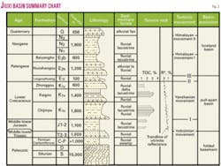
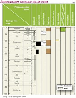
The Jiuxi foreland basin developed overlying a pre-Jurassic folded basement. Basin fill consists of Carboniferous, Permian, Lower-Middle Triassic, Lower-Middle Jurassic, Lower Cretaceous, Tertiary, and Quaternary, dominantly nonmarine deposits (Fig. 3).
The basement of folded and metamorphosed Lower Paleozoic rocks consists of extremely thick marine deposits.7 The Devonian contains mainly purplish red fluvial sandstones and conglomerates, and some continental andesite and basalt that are also folded.
The Lower-Lower Carboniferous and Permian consist of about 1,000 m of transitional marine-nonmarine deposits mainly of sandstone with limestone and coal that were deposited in the marginal foreland basin settings after the Early Paleozoic ocean was closed.8
The Middle and Lower Triassic contain 1,000 m of fluvial-deltaic and lacustrine sandstone, siltstone, mudstone, and coal.9
The Middle and Lower Jurassic contain up to 1,100 m of fluvial-lacustrine pebbly sandstone, mudstone, and coal and are mainly at the piedmont side of the basin.
The Lower Cretaceous contains mainly alluvial and lacustrine deposits of upward Chijinpu, Xiagou, and Zhonggou formations. The Chijinpu formation has mainly sandstone and conglomerate in the lower part, dark gray mudstone in the middle part, and interbedded sandstone and mudstone in the upper part. Lateral facies changes are common in the Xiagou and Zhonggou formations.10
On the basin margin, purplish red sandstone, conglomerate, and mudstone are dominant and form one of the main oil reservoirs. Dark-gray mudstone, dolomitic mudstone, and black mudstone are in the central part of the basin as the key source rocks.
The Paleogene strata are dominantly fluvial-lacustrine purplish red mudstone and brownish red sandstone-conglomerate up to 2,000 m thick that were interpreted as being deposited in an arid climate.
The Neogene strata are primarily grayish white fluvial and lacustrine sandstones intercalated with brownish red mudstone. The Quaternary deposits are mainly piedmont conglomerates.
Basin evolution
In reference to basin type and evolution, formation of the Jiuxi basin has undergone three stages (Fig. 3).
Stage of basement formation. The northern Qilian oceanic basin underwent convergence closure at the end of the Caledonian Orogeny to form the northern Qilian orogenic belt was amalgamated with the northern Alashan landmass. Together they formed the folded basement for the overlying Mesozoic-Neozoic basins in the Hexi Corridor.
During Early and Middle Devonian, piedmont molasses were deposited on the edge of the northern Qilian fold belt. During Carboniferous and the earliest Permian, a mixed marine-nonmarine coal-bearing succession was deposited associated with an extensive marine transgression.
After a hiatus, typical continental clastic rocks were deposited during the Early-Middle Triassic. Thereafter, Upper Triassic was absent probably due to regional uplift associated with the Indosinian Orogeny.
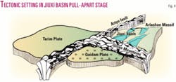
Stage of pull-apart and rift basin. The amalgamation of the Qinghai-Tibet Plate with the Northern China Plate in Jurassic and Early Cretaceous caused the northeastern movement of both the Qilian fold belt and the Alashan Massif via strike-slipping along the Arkin fracture.6
A more rapid eastward movement of the Alashan Massif caused a clockwise transtensional movement at the joint between the Qilian fold belt and the Alashan Massif, resulting in sets of NE-oriented fractures and transtensional rift basins11 (Fig. 4). Depocenters at both the northern and southern ends of the rift basins were filled with lacustrine facies.
Outcrop data indicate that the Middle-Lower Jurassic Longfengshan Group overlies unconformably the Middle-Lower Triassic Xidagou formation. The Yanshan Orogeny started at the end of Middle Jurassic and deformed pre-Cretaceous strata through faulting and folding.12 The Middle-Lower Jurassic strata are sparsely present in the basin probably due to strong folding and erosion.
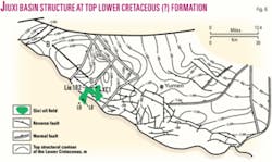
The major northern fault of the Qilian Mountains was overthrust towards basins during this stage.13 At the Early Cretaceous, the transtensional movement formed a NE-trending half-graben basin with a faulted margin in the east and a ramp margin in the west. The Lower Cretaceous strata are 3,000-5,000 m thick (Fig. 5).
Fan delta conglomerate and sandstone were deposited at the basin margin and lacustrine shale, micritic limestone, and shaly dolomite in basin center.10 During the Early Cretaceous, the rift basins experienced three phases: early rapid rifting, middle slow rifting, and late drifting, corresponding to deposition of the Chijinpu, Xiagou, and Zhonggou formations. Upper Cretaceous and Paleocene deposits are absent probably because of concurrent regional uplift.
Stage of foreland basin and thrust belts. Foreland basins formed in the piedmont areas due to intense uplift of the Qilian Mountains and northward compression from the latest Eocene to Oligocene,14 and 1,900 m of clastic rocks were deposited.
The Huoshaogou formation is a succession of interbedded alluvial brownish red conglomerate and fluvial and lacustrine sandstone and mudstone deposited in an arid climate.
The Baiyanghe formation consists principally of brownish red interbedded mudstone and conglomerate-sandstone.
The Pliocene consists of 1,000-2,000 m of dominantly fluvial and lacustrine conglomerate, sandstone, and mud rock deposited in an arid climate. Faulting and thrusting intensified at the northern edge of the Qilian Mountains at the end of Pliocene due to the distal effect of the collision between the Indian and Asian plates and the uplifting of the Qinghai-Tibet Plateau, resulting in the formation of large thrust and nappe structures.
Both the sedimentary cover and basement were being involutedly deformed, becoming parts of the nappe at the northern edge of the Qilian Mountains. In this stage, the structural style in the basins had basically patterned. The northern Qilian orogenic belt has been rapidly uplifted, and pluvial facies has been deposited in the basins during the Quaternary.
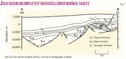
The sedimentary fill in the Jiuxi basin can be divided into two structural units (Fig. 6). The lower unit features NE-trending normal faults in the Jurassic-Cretaceous.11 The Himalayan compression partially inversed the normal faults. However, as for most boundary faults of transtensional rift basins, the inversion was incomplete.
At present, the faults remain to be normal faults (Fig. 7) or “normal fault in the lower part and reverse fault in the upper part.” The upper structural unit features NW-trending thrust faults and fault-related folds, forming an imbricated thrust system, which consists of the piedmont nappe structural belt in front of the northern Qilian Mountains in the south, the Laojunmiao thrust and fold belt in the middle, and the Baiyanghe thrust belt in the north (Fig. 2).
Petroleum system
Source rock. Dark gray and gray lacustrine shaly dolomite and dolomitic shale of the Lower Cretaceous Xiagou and Chijinpu formations are the source rocks in Jiuxi basin.15-17 They are mainly in the Qingxi Depression and thicken from 2,400 m at basin margin to 3,200 m at depocenter.
Total organic carbon is 0.6-2.0% (Table 1). Type II kerogen dominates with some types I and III kerogens. Hydrocarbon generation potential (S1 + S2) exceeds 6 mg/g. Kerogens in the Xiagou formation are mature with some submature; those in the Chijinpu formation are mature to highly mature.
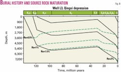
Analyses of burial history, hydrocarbon generation, and evolution history indicate that hydrocarbon generation occurred principally at the end of Tertiary18 (Figs. 8 and 9).
Reservoir rock. Reservoir rocks in the Jiuxi basin include Paleogene, Lower Cretaceous, and Middle-Lower Jurassic nonmarine clastic rocks, Lower Cretaceous lacustrine shaly dolomite, and Silurian fractured metamorphic rocks. Coarse to fine-grained sandstones of alluvial, braided stream, and deltaic origins in the Paleogene Baiyanghe formation have a porosity of 24% and permeability of 10-1,200 md with a mean value exceeding 100 md.
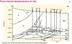
The Xiagou formation contains important porous fractured reservoir rocks (Fig. 5). In the piedmont area, the reservoir rocks are mainly alluvial-fan conglomerate, 100 to 400 m thick, and have a porosity of 6-19% (averaged at 8%) and a permeability of 0.987-44.4 md.
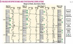
The lacustrine depocenter contains dolomite, shaly dolomite, and dolomitic shale, which are widely distributed and laminated. Their reservoir quality is poor, with a porosity of 1.27-7.13% (averaged at 4.31%) and a permeability of 0.1-1.6 md.19 They are, however, extensively fractured near faults, forming porous fractured reservoirs (Fig. 10). Silurian metamorphic reservoir rocks are also fractured.
Cap rock. Illite and smectite-rich mudstones of the Paleogene Baiyanghe formation are the regional cap rocks with good seal capacity in the Jiuxi basin. Their illite content is 40-60% and smectite 30-40%.20
The cap rocks cover the entire basin but thin from 140 m in the Qingxi Depression to 20 m at the basin margin. The cap rocks that overlie the Cretaceous oil pools are mud rocks at the top of the Xiagou formation and in the lower part of Zhonggou formation. The thickness is 50-150 m, with a maximum thickness of 400 m in depocenter in the mountain front.
Migration and accumulation. Oil to source rock correlations8 suggest that the oil is mainly from the Lower Cretaceous source rocks.
Oil generated in the Cretaceous source rocks in the lacustrine depocenter first accumulated in the shaly dolomite close to the kitchen and then neighboring fan-delta conglomerates at the basin margin, which formed lithostratigraphic traps. Thereafter, oil migrated along faults and-or unconformities and accumulated in structural traps and buried-hill traps. As a result, each structural belt has its own specific reservoir type.
Resources and reserves. Oil resources are estimated as 0.533 billion tons in the Jiuxi basin, among which accumulations in Cretaceous rocks account for 70%, Tertiary for 23%, and Silurian for 7%.
The total proved reserves in six oil fields are 148 million tons, among which Tertiary reserves account for 67.4%, Cretaceous for 23.1%, and Silurian for 9.5%.
Remaining resources are 0.396 billion tons, among which the Cretaceous resources account for 80%, Tertiary for 13%, and Silurian for 7%. This estimate suggests that the Cretaceous rocks have excellent prospecting potential.
Structural definition and trap configuration. The Kulongshan anticline under the Paleozoic nappes in the Qilian Mountain front is large and elongate with a gentle and broad eastern limb and a steep and narrow western limb in the map view.
The Kulongshan anticline covers 132 sq km with 1,800 m of closure. The anticline is covered by the overthrust for 6-8 km with a structural area of 97.8 sq km (Figs. 2 and 11).
The Kulongshan structure is composed of NW-trending thrusts and nearly NS-trending tear faults. The north flank is relatively steep where faults developed, while the southern flank is relatively gentle, where the Cretaceous and Tertiary strata were overthrust by Paleozoic (Silurian to Permian) metamorphic rocks.
In the piedmont nappe, hydrocarbon shows occur in the Silurian to Cretaceous interval in both hanging wall and foot wall. But the key target beds are in the Cretaceous Xiagou formation in the foot wall. The reservoirs are controlled by both lithology and fractures.
Reservoir architecture and properties. Oil accumulation in the Xiagou formation is primarily controlled by structure and lithofacies in Qingxi field. For instance, the dimensions of Kulongshan reservoirs are confined by structures (Figs. 11 and 12), with the same depth of oil-water contacts at -2,200 m elevation. The reservoir rocks are sandstones and conglomerates of fan-delta front facies (Fig. 13).
In the Liugouzhuang region, the oil-water contact is at -2,000 m elevation; and the reservoir rocks are lacustrine shaly dolomite and fractured dolomitic shale, which have a low matrix porosity but relatively high permeability and high oil production (Table 2) due to extensive fracturing.
Next: Jiuxi basin exploration history, use of modern technology, and lessons learned and their broad exploration implication.
The authors
Wenzhi Zhao ([email protected]) is a professor and the vice-president of Research Institute of Petroleum Exploration and Development of PetroChina. His research interests include petroleum systems and integrated geologic assessment of superimposed sedimentary basins in China. He has a BS from Northwest University, China, and MS and PhD degrees from RIPED.
Zechen Wang is a senior geologist of RIPED. His research interests include petroleum structural analysis, natural gas geology, and integrated geologic assessment of reservoirs. He has a BS and MS from China University of Geosciences and a PhD from China University of Mining & Technology.
Jianjun Chen is a senior geologist and the vice-manager of Yumen Oilfield Co. of PetroChina. His profession highlight focuses on petroleum exploration of sedimentary basins including the Jiuxi basin in the Hexi Corridor of Central China. He has BS, MS, and PhDs from Southwest Petroleum Institute (China).
Yongke Han is a senior geologist of Yumen Oilfield Co. of PetroChina. He has a BS from China University of Geosciences in 1988 and an MS from Southwest Petroleum Institute (China).


