New assessment for Central Nigeria's Bida basin highlights geological prospects
Nuhu G. Obaje
Ibrahim Badamasi Babangida University
Lapai, Nigeria
Abdullahi Idris-Nda Aliyu I. Goro Salihu H. Dantata
Federal University of Technology
Minna, Nigeria
Anthony U. Okoro Eliseus O. Akpunonu
Nnamdi Azikiwe University
Awka, Nigeria
Shadrach B. Jatau
Nasarawa State University
Keffi, Nigeria
The Bida basin is the least studied of all Nigeria's inland frontier basins. To date, no exploratory wells have penetrated its sequences, and subsurface data are limited.
Preliminary geological and prospectivity mapping presented in this study defines resource potential in the Bida basin. In addition, processed and interpreted geophysical aeromagnetic data assess depth to basement and basement topography, and redefine locational prospectivity.
Available geochemical data show that hydrocarbon source rocks exist within the Enagi and Patti formations in the northern and southern sections, respectively. Aeromagnetic data indicate depths of more than 2,000 m within the identified prospects.
The present study serves as a basis for accelerating investment decisions on new business opportunities, defined here as open acreage in Nigeria's sedimentary basins not yet licensed out by the government's Department of Petroleum Resources but with potential for hydrocarbon accumulation.
Inland basin studies
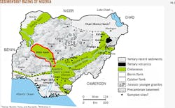
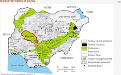
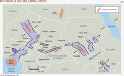
The Bida basin, also known as the Mid-Niger or Nupe basin, is in north-central Nigeria and is one of several Cretaceous and later rift basins in Central and West Africa whose origins are related to the opening of the South Atlantic (Fig. 1). Several commercial discoveries have been made in these rifted inland basins (Fig. 2).1 2
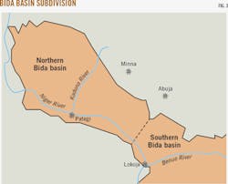
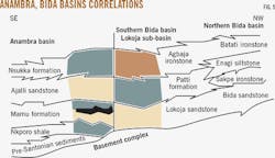
Bida basin is generally subdivided into northern and southern portions (Fig. 3). Literature on the Bida is scant, unlike similar inland basins in Nigeria that have been more documented. In the early 1970s, researchers documented the stratigraphy and sedimentation of Upper Cretaceous succession in the central parts of the basin around Bida.3 The study defined and established the lithostratigraphic units geologists continue to use for studying theBida basin.
Interpretations of Landsat imageries and borehole logs and geophysical data suggest that the basin is bounded by a system of linear faults trending NW-SE. Gravity studies point to a series of central positive anomalies flanked by negative anomalies, similar to the adjacent Benue trough and typical of rift structures.4 5
University-based research on aero and ground-magnetic and gravimetric geophysical surveys are available for parts of the Bida basin.6 These works generally corroborate that it is bounded by linear faults.4 5
In addition to preliminary stratigraphic investigations, geologists carried out further analyses through the late 1980s that located and described type localities and type sections for the Bida basin's geologic formations.3 7-9
Sedimentology in parts of the southern Bida basin ascribe fluvial depositional models to the Lokoja formation and parts of the Patti formation.10-12 Data show relatively good quality reservoir rocks in portions of these formations.
Geochemical results on source-rock samples from the Patti formation in the southern Bida basin reveal sedimentary organic matter in the early stages of oil generation.2 13 Organic matter is also more prone for gas than oil.
Processing
The scope of the present work consists of geological mapping, geophysical aeromagnetic data acquisition, processing, interpretation, and results integration to delineate prospective areas.
Our team collected samples throughout the entire Bida basin to produce a comprehensive geological map and obtain good quality rocks for analytical studies. We validated correlations of the rock units with macrofossil assemblages as they occurred in the field while simultaneously performing structural analyses. The resulting geological map constructs subsurface cross-sections to delineate areas with thicker sediment piles.
The Nigerian Geological Survey Agency (NGSA) supplied aeromagnetic maps covering the Bida basin. Once processed, these maps helped determine probable depths to basement, basement topography, and buried magnetic materials. We processed field magnetic data with mathematical operations of the Fast Fourier transform (FFT) algorithm, a precursor of spectral analysis. We then converted the aeromagnetic raw data to depths-to-basement on a color index scale with Geosoft software.
Prospects, interpretations
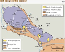
Preliminary geological mapping (Fig. 4) revealed some composition details, aerial extent, and the inferred boundaries of the formations in the Bida basin. All previous geological maps available on the Bida basin lumped the sediments into one undifferentiated formation, Nupe sandstone, making it impossible to infer prospectivity for hydrocarbon exploration and acreage assessment.
The delineation of inferred boundaries between the formations in the basin is an initial criterion for evaluating hydrocarbon prospects. These geological mapping exercises corroborated the four lithostratigraphic formations in the northern Bida basin and the three in the southern Bida basin identified by earlier research.
In the northern Bida basin, four mappable lithostratigraphic units are recognized, namely, the Bida sandstone (divided into the Doko member and the Jima member), the Sakpe ironstone, the Enagi siltstone, and the Batati formation. These correlate with the stratigraphic units in the southern Bida basin (Fig. 5).
In the southern Bida basin, which has been studied in more detail, exposures of sandstones and conglomerates of the Lokoja formation directly overlie the Precambrian to Lower Palaeozoic basement gneisses and schists.13 14 This formation is overlain by the alternating shales, siltstones, claystones, and sandstones of the Patti formation, which is 70-100 m thick in the Koton-Karfi and Abaji axes. The Patti formation is succeeded by the claystones, concretionary siltstones, and ironstones of the Agbaja formation.
This study defined boundaries between the formations in preparing the geological-prospectivity map, the first complete geological map of the Bida basin (Fig. 6).
Prospectivity
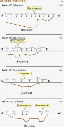
The Bida basin contains horst and graben structures, whereas the deepest grabens lie below the Batati and Agbaja formation outliers. These outliers, which may be considered "geological bright spots," represent the most prospective areas in the Bida basin. Pattishabakolo, Edozighi, Kandi, and Enwan are the bright spots in the northern Bida basin, whereas Agbaja and some localities around Gegu-Beki constitute the geological bright spots in the southern Bida (Figs. 7a-d).
Most of the areas covered by the Enagi and Patti formations are presumed to be of relatively moderate depth-to-basement with the depth increasing towards the center of the basin (Fig. 7c). These areas are prospective in terms of sediment thickness but relatively less prospective than the areas covered by Batati-Agbaja formations, including areas around Adogo, Pizhi, Duba, Kachegi, Kutigi, Ndaba, Badegi, Agaie, Gulu, Muye, Gerinya, Abaji, Ahoko, and Gegu-Beki.
The least prospective areas are those covered by the Bida sandstone, including Bida, Doko, Jima, Baro, Wushishi, Pategi, Kotonkarfe, and Lokoja (Fig. 6).
Aeromagnetic data
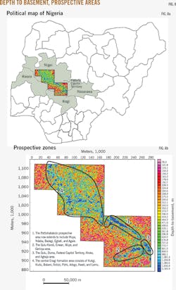
The aeromagnetic data comprise the raw data acquired from NGSA and the processed and interpreted data that show the depth to basement in a color index (Fig. 8a, b). We obtained raw data from most of the sheets (individually) covering the sedimentary layer of the Bida basin and merged these together for a composite interpretation.
The results of aeromagnetic processing and interpretations have assisted in better defining the earlier geologically postulated prospective areas. Aeromagnetic geophysical measurements normally target magnetic materials (magnetic minerals and rocks), which are typically more abundant in basement rocks than in sedimentary rocks.
Most interpretations assume zero value for sedimentary cover. Deeper-lying basement receives lesser values than near-surface basement or higher concentrations of magnetic minerals such as haematite, ironstones, and others. For this reason, the aeromagnetic data for the Bida basin must be carefully juxtaposed against the geological map. This is important because the Bida basin is the only sedimentary basin in Nigeria with abundant ironstones in its formational lithologies (Sakpe ironstone, Batati ironstone, Agbaja ironstone). Its other formations also contain measurable amounts of ferruginous components. Data over these areas may be interpreted as near-surface basement whereas the high magnetic values may result from thick sections of sedimentary ironstones.
Preliminary interpretation of aeromagnetic data over the Bida basin agrees generally with the geological mapping interpretation except that the aeromagnetic interpretation has widened the extent of prospective areas (Fig. 8a). The interpreted aeromagnetic data map is divisible into four prospective zones that generally correlate with the geologically defined prospective areas (Fig 8b):
• Zone 1 is made up of a deep NW-SE trough containing the Pattishabakolo prospective area extending through Wuya, Ndaba, Badegi, Egbati, and Agaie.
• Zone 2 is the E-W trench of the Gulu, Kandi, Enwan, Muye, and Gerinya prospective area.
• Zone 3 prospective areas correlate with the Gulu, Duma, FCT, Ahoko, Agbaja trough.
• Zone 4 is the geologically mapped Enagi surface cover in the northwestern portion of the basin with prospective areas covering Kutigi, Kudu, Bokani, Robizi, Pizhi, Adogo, Kwati, and Lemu. Most parts of Zone 1, Zone 2, and Zone 3's prospective areas have been filled with the Batati formation at surface, even though the Batati formation was mapped only as isolated outliers (Fig. 6).
It is probable depths-to-basement are independent of formational correlation or that the Batati formation was eroded in most parts where it should have been encountered. The geological map in Fig. 6 shows that the central part of the northwestern portion of the Bida basin, which is widely covered with the Enagi formation, would have isolated deep sections of prospective areas. This interpretation conforms to the aeromagnetic data interpretation for that zone.
Prospect range, localities
For the prepared geological map, prospective areas are discernably ranked from "less" prospective and "prospective" to "more" prospective. Pattishabakolo, Edozighi, Kandi, and Enwan make up the more prospective localities in the northern Bida basin, whereas Agbaja and some localities around Gegu-Beki constitute the geological bright spots in the southern Bida basin.
Although the aeromagnetic interpreted data did not give exact depth to basement, they show that most of the identified prospective areas have sediment thicknesses beyond 2,000 m. Based on early geophysical evaluation, the first wells to be drilled in the basin should be at Pattishabakolo (near Bida) and at Kandi (near Gulu). Other sites can be determined by additional studies and further lease-operator investigation.
Acknowledgments
This study was funded by the Niger State Government through Ibrahim Badamasi Babangida University, Lapai. The Executive Governor of Niger State (2007-15), Mua'zu Babangida Aliyu, and the Vice Chancellor of Ibrahim Badamasi Babangida University (2010-14), Ibrahim Adamu Kolo, are thanked for their support and supervision.
References
1. Mohamed, A.Y., Pearson, M.J., Ashcroft, W.A., Illiffe J.E., and Whiteman, A.J., "Modeling petroleum generation in the Southern Muglad rift basin, Sudan," AAPG Bulletin 83, December 1999, pp. 1,943-1,964.
2. Obaje, N.G., Wehner, H., Scheeder, G., Abubakar, M.B., and Jauro, A., "Hydrocarbon prospectivity of Nigeria's inland basins: from the viewpoint of organic geochemistry and organic petrology," AAPG Bulletin 87, March 2004, pp. 325-353.
3. Adeleye, D.R., and Dessauvagie, T.F.J., "Stratigraphy of the Mid-Niger Embayment near Bida, Nigeria," Proceedings of the Conference on African Geology, 1972, pp. 181-186.
4. Ojo, O.M., "Prospects of finding uranium deposits in Nigeria," Nigerian Journal of Mining and Geology 17, 1980, pp. 1-12.
5. Ojo, S.B. and Ajakaiye, D.E. "Preliminary interpretation of gravity measurements in the Mid-Niger Basin area, Nigeria," Geology of Nigeria, 2nd Ed., 1989, pp. 347-358.
6. Udensi, E.E., and Osazuwa, I.B., "Spectral determination of depths to magnetic rocks under the Nupe Basin, Nigeria," Nigerian Association of Petroleum Explorationists (NAPE) Bulletin 17, 2004, pp. 22-27.
7. Adeleye, D.R., "Sedimentology of the fluvial Bida Sandstones (Cretaceous), Nigeria," Sedimentary Geology 12, September 1974, pp. 1-24.
8. Adeleye, D.R., "Nigerian Late Cretaceous stratigraphy and paleogeography," AAPG Bulletin 59, December 1975, pp. 2,302-2,313.
9. Adeleye, D.R., "The Geology of the Mid-Niger Basin," Geology of Nigeria, 2nd Ed., 1989, pp. 283-287.
10. Braide, S.P., "Geologic development, origin and energy mineral resource potential of the Lokoja Formation in the southern Bida Basin," Journal of Mining and Geology 28, 1992a, pp. 33-44.
11. Braide, S.P., "Syntectonic fluvial sedimentation in the central Bida Basin," Journal of Mining and Geology 28, 1992b, pp. 55-64.
12. Braide, S.P., "Alluvial fan depositional model in the northern Bida Basin," Journal of Mining and Geology 28, 1992c, pp. 65-73.
13. Akande, S.O., Ojo, O.J., Erdtmann, B.D., and Hetenyi, M., "Paleoenvironments, organic petrology and Rock-Eval studies on source rock facies of the Lower Maastrichtian Patti Formation, southern Bida Basin, Nigeria," Journal of African Earth Sciences 41, June 2005, pp. 394-406.
14. Ladipo, K.O., Akande S.O., and Mucke, A., "Genesis of ironstones from the Mid-Niger sedimentary basin: evidence from sedimentological, ore microscopic and geochemical studies," Journal of Mining and Geology 30, 1994, pp. 161-168.
The authors
Nuhu G. Obaje ([email protected]) is dean of the Applied Sciences and Technology Faculty at Ibrahim Badamasi Babangida University, Lapai, Nigeria. He holds a BSc and MSc in geology from Ahmadu Bello University, Zaria, Nigeria, and a PhD in Geology from the University of Tuebingen, Germany.
Abdullahi Idris-Nda ([email protected]) is senior lecturer at the Federal University of Technology, Minna, Nigeria, where he also received his masters in hydrogeology (2002) and a PhD in geology and hydrogeology in 2010. He received his BSc in geology from Ahmadu Bello University, Zaria.
Anthony Okoro ([email protected]) is a senior lecturer, and immediate former head, in the Department of Geological Sciences at the Nnamdi Azukiwe University, Awka, Nigeria. He has also worked with the Geological Survey of Nigeria and with Core Laboratory Ltd. in Port Harcourt.
Eliseus O. Akpononu ([email protected]) is a senior lecturer and current head of the Department of Geological Sciences at the Nnamdi Azikiwe University, Awka. He obtained a BSc in geology from the University of Nigeria, Nsukka, in 1984 and an MSc in applied geophysics and PhD in petroleum geology from the Nnamdi Azikiwe University, Awka, in 2002 and 2008, respectively. He has also served as geotechnical consultant to Orient Petroleum Resources Ltd. and the Central Bank of Nigeria.
Shadrach B. Jatau ([email protected]) is an associate professor and dean of the Natural and Applied Sciences at Nasarawa State University, Keffi. He also served as chief lecturer and head of the Mineral Resources Engineering Department at Kaduna Polytechnic, Kaduna. He holds a MSc and PhD in geological sciences with specialization in applied geophysics and minerals from the Nnamdi Azikiwe University, Awka, Nigeria.
Aliyu I. Goro ([email protected]) is a final year PhD student at Abubakar Tafawa Balewa University, Bauchi. He holds an MSc in petroleum geosciences from the University of Manchester, UK, and a bachelors from the Federal University of Technology, Minna.
Salihu H. Dantata ([email protected]) is a PhD student at the Federal University of Technology, Minna, where he also received a BS in geology. He holds a MSc in petroleum technology from the University of Teesside, Middlegourough, UK.
