Permanent monitoring enhances life of field reservoir management
Rocco Detomo Jr.
Omoted Geophysical Consulting
Indian Harbour Beach, Fla.
Although permanent reservoir monitoring (PRM) technology is in its infancy, certain components, such as life-of-field seismic (LoFS) systems, are becoming more commonplace.
Repeating measurements for a field over the development life cycle requires positional and technical accuracy, and permanent installations can mitigate problems associated with repeatability (e.g., when placing and removing seismic sensors). Cost can be high, however, especially in new field developments for which uncertainties often run highest, but added value can justify the expenditure.
Within the past decade, several major fields have served as testing grounds for permanent installations. These fields now stand as maturing examples that display the value and range of new geophysical instruments that have proven capable of repeatedly and accurately monitoring subsurface properties as they change throughout the life of a field.
These systems cover several areas, including:
• Life of field seismic systems: permanently deployed acoustic (seismic) sensors on the seafloor.
• Geodesic instrumentation: seafloor sensors that monitor subsidence and lateral movement of the seafloor, usually through ranging and pressure measurements.
• Downhole geophysical sensors: permanently deployed wellbore sensors, particularly optical systems, which can be Bragg Grating or distributed acoustic sensors (DAS).
Seafloor seismic systems
Reservoir monitoring with LoFS systems is based upon the extensive application and success of acquiring repeated, nonpermanent areal seismic imaging (4D). The methodology measures velocity and density changes in the subsurface by accurately repeating 3D seismic surveys and interpreting the small and subtle changes detected in subsequent seismic shoots.
Repeat 3D and 4D seismic surveys demonstrate value by driving down uncertainty and increasing dollars per barrel of oil over the life of a field. LoFS systems are most effective early in a field's development cycle when subsurface reservoir uncertainties can have the greatest impact. Repeat seismic also is useful during a field's productive life to monitor for unexpected subsurface responses. For a field's end-of-life, 4D seismic is capable of identifying bypassed reserves or remaining opportunities.
Frequent offshore 3D areal seismic does not necessarily require permanent seafloor systems. There are, however, a growing number of offshore developments that are excellent candidates for such LoFS systems:
• Surface infrastructure affects seismic towed-streamer vessel coverage, reducing survey repeatability and increasing costs.
• Seafloor infrastructure limits or excludes the use of recoverable ocean-bottom cable (OBC) systems and reduces survey repeatability.
• Difficult reservoirs with high production rates or water injection that may require seismic on demand, which is difficult to accomplish with these large, multipurpose systems.
Recently, some of these limitations have been tackled by the growing availability of ocean-bottom node (OBN) systems, which are highly repeatable and deployable under and near surface and subsurface infrastructure. The quality of 4D seismic acquisition depends strongly upon the positioning repeatability of seismic sources and receivers.
Although industry has made great strides in seismic source vessel repeatability, receiver repeat positioning has varied to as accurate as ~1 m for ocean-bottom nodes from up to ~50 m for towed streamers. Deployment of nodes to the seafloor in deep water requires the use of remotely operated vehicles (ROVs), which can increase the cost of seismic shoots 2-3 times that of a comparable towed-streamer survey.
Although cost is an important consideration, observations from various marine 4D acquisition studies have indicated that price difference is not absolute. High-resolution streamer surveys (higher multiplicity than typical exploration seismic surveys) with dedicated undershoots for surface obstructions use multiple vessels and are sometimes more expensive than OBN for even a single survey.
Cost increases occur because many field development seismic surveys are small (100-200 sq km) and vessels with towed streamers gain their cost effectiveness by covering large areas with little time spent changing the vessel's direction. Surface obstructions create complex seismic survey designs that take more time to acquire.
If only an "average" 4D repeatability is needed, however, and there is clear surface access, narrow towed streamer 4D repeat surveys may suffice.
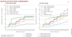
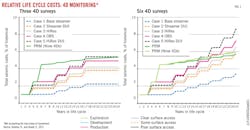
Often, there is a choice between executing multiple 4D areal seismic surveys over a field, as needed, vs. installing a LoFS system upfront. Initial costs for equipment and installation of an LoFS system is high ($50-100 million), but the cost of subsequent seismic 4D monitor surveys is considerably reduced ($2-7 million each). In this case, a large number of repeat surveys over a field's life make permanent LoFS systems more cost effective (Fig. 1).
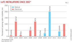
Since 2002, several offshore fields have been developed with LoFS systems (Fig. 2). Early systems were deployed in the North Sea, where monitoring reservoirs that have complex faulting and connectivity uncertainty would deliver valuable subsurface information. These early systems were electrical in design and amounted to a seafloor version of an onshore permanent receiver array wired to the platform at the surface.
Recently, we've seen the advent of optical systems that use fiber optic sensors and move data from the seafloor through the use of lasers at the platform. The belief is that removing electrical components from the marine environment and locating all active components within the topsides control center will improve the LoFS sensitivity and reliability over the extended (25 years or longer) life of an offshore development. In addition to the North Sea, offshore fields in the Gulf of Mexico and Brazil are monitored with marine LoFS systems.
In some cases, novel designs can provide "patch" 4Ds, such as instantaneous 4D (i4D). Nevertheless, reservoir monitoring remains a mix of development-plan validation (e.g., Is the oil-water contact moving uniformly as was expected?) and reactionary investigation (e.g., Where is the water from an injector going?). Often, the best way to accommodate this mix is to have a permanent LoFS system in place, which streamlines the requirements for subsequent budgeting, contracting, and permitting.
In the future, marine LoFS systems will gain broader deployment that will be characterized by several likely technical developments:
• Growth in fiber optic systems integrated with other fiber-control and instrument systems deployed on the seafloor and brought back to data centers, especially with subsea systems.
• Emergence of long-life autonomous recorders (nodes), enabled by:
• Remote operations via acoustic commands.
• The maturing of seafloor power solutions.
• The development of a robust optical data transmission link in seawater.
• Growth of novel, targeted geometries (e.g., i4D) and hybrid strategies for 4D.
• Development of permanent, more portable, and less expensive acoustic sources.
• Increase in exploitation of passive listening and recording and marine microseismic enabled by LoFS.
Geodesic instrumentation
Marine areal 4D monitoring is predicated on the exact repetition of the seismic experiment, such that changes may be ascribed to reservoir production effects. Although we can control the accuracy of the placement of the sources and receivers, we cannot control the seasonal and diurnal changes in the water column. These effects are small, but temperature, depth, and salinity variations do change the water's velocity.
These variables give rise to differences between subsequent seismic surveys, even down to the length of acquisition time for a single survey. Seafloor sensors are useful, such as depth and pressure recorders or vertical water velocity ranging instruments that monitor these changes.
Seafloor sensors may be used to address other issues. For instance, although areal 4D seismic monitoring can address many subsurface questions, it depends completely on the ability to detect changes in density and velocity at or near the reservoir level. Sometimes, operators wish to monitor larger scale changes in the subsurface or examine changes that may not manifest themselves as a measurable change in the seismic response. In these cases, other geophysical tools and instruments are available for marine reservoir monitoring including:
• Seafloor depth and pressure recorders.
• Seafloor lateral ranging recorders.
• Seabed gravity meters.
Unfortunately, these types of instruments are often decoupled from each other and not always commercially available. Integrated sensing stations will see more deployment opportunities as seafloor systems continue to multiply. In particular, the next few years should see the emergence of an integrated instrumented seafloor recording station that includes:
• An accurate, calibrated pressure sensor.
• Further distance ranging to other sensing stations.
• Water column velocity measurement capability.
• Equipment that can accurately measure gravity and gravity gradiometry.
• Sensors that respond to and record acoustic signals triggered by microseismic events.
Emerging downhole sensors
One of the most recent advances in reservoir monitoring technologies is the use of downhole fiber optic sensors. These systems are based on the sensitivity of optical fiber. Changes in the downhole environment (acoustic waves, temperature, and pressure) can be accurately interrogated by lasers at the surface, which then provide detailed information on subsurface conditions.
Sensors fall into two broad classes: point and distributed. Point sensors are based on Bragg gratings distributed along the fiber. Distributed sensing is measured continuously along the fiber with natural backscattered light. Distributed acoustic sensing (DAS) is particularly attractive because it provides for a tiny, robust, and passive line of sensors that can easily and permanently be deployed in a well, either on casing or on tubing.
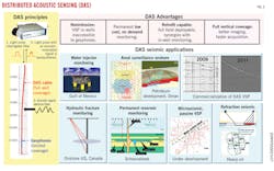
DAS for wellbore acoustics can assist in monitoring wellbore performance and can serve as downhole sensors for passive microseismic monitoring and active borehole geophysical surveys: vertical seismic profiles (VSPs) and cross-wellbore tomography (Fig. 3). DAS also has the potential to accelerate large scale 3D VSPs.
Other advantages offered by DAS technology include an "already wired" well as permanent deployment of optical fiber results in zero rig time required for data collection. In addition, the cost of purchasing and deploying DAS fibers may be less expensive than running geophones downhole in a conventional 3D VSP. The permanent installation also gives way to VSP on demand as data acquisition can be acquired at any time.
DAS technology does have limits. To date, these systems have been proven offshore only on wells with dry trees and without complex downhole hardware.
Subsea engineering is rapidly moving to provide safe and certified optical passthrough solutions for all marine applications. Over the next few years, as these solutions mature and wells are outfitted with optical fibers for a multitude of measurements, DAS data acquisition will see a growing application in offshore wells due to the following advances:
• Improved instrumentation.
• More sensitive interrogators (+ ~24db S/N).
• More dense receiver spacing (<1 m).
• More channels/receivers (>50,000/interrogator).
• More rugged fibers.
• New fiber optic deployment standards and procedures.
• Accommodating well equipment and design (wellheads, packers, etc.)
• Increase in active source wellbore geophysics (VSP and cross wellbore)
• Growth in wellbore passive geophysics (e.g., microseismic)
Real time advances
The industry should expect rapid acceleration in offshore reservoir monitoring with both proven and emerging technologies. Increased monitoring will be driven by the economic demands of effectively producing more difficult reservoirs by closely tracking production. Additionally, increased improved oil recovery (IOR) and enhanced oil recovery (EOR) of historically prolific fields along with identification of bypassed reserves will continue to add value to permanent monitoring systems.
Aside from economics, more social scrutiny and an increase in regulatory requirements will drive this technology, especially with respect to out-of-zone injection, reservoir and earth deformation, and fault reactivation. The proliferation of fiber optic and autonomous systems designed as integrated remote sensing and data transmission centers also will provide acceleration.
The expectation is that these advances in technology will result in higher reservoir recovery efficiency, more efficient use of capital, compressed field lifecycles, and improved access to difficult reserves. These systems, however, will also give rise to a general growth in remote sensing and operations. Larger datasets will be acquired in real time, which will continue to demand larger, faster computing systems. Ultimately, this will provide increased end-to-end integration across businesses, between disciplines, and across data types.
Bibliography
Bett, M.A., "Alternative Business Models to Overcome Barriers to PRM," European Association of Geoscientists & Engineers Workshop on Permanent Reservoir Monitoring (PRM)-Using Seismic Data, Trondheim, Feb. 28-Mar. 3, 2011.
Detomo, R., "Emerging Offshore Geosciences Technologies in Permanent Reservoir Monitoring," Offshore Technology Conference, Houston, May 4-8, 2014.
Detomo, R., "4D Time‐Lapse Seismic Reservoir Monitoring of African Reservoirs," (after F. Smit, et al), Society of Exploration Geophysicists, Africa and Middle East Honorary Lecture, Cairo, Dec. 6, 2012.
Detomo, R., and Quadt, E., "Life-Cycle Seismic for Turbidite Fields in Deepwater Nigeria," Society of Exploration Geophysicists Annual Meeting, San Antonio, Sept. 18-23, 2011.
Detomo, R., Berlang, W., van der Horst, J., Lopez, J., and Potters, H., "In-Well Distributed Fiber Optic Solutions for Reservoir Surveillance," Offshore Technology Conference, Houston, May 6-9, 2013.
Detomo, R., "Perspective of a Career in Upstream Oil & Gas," Offshore Technology Conference, Houston, May 6-9, 2013.
Eiken, O., Stenvold, T., Zumberge, M., Alnes, H., and Sasagawa, G., "Gravimetric Monitoring of Gas Production from the Troll Field," Geophysics, Vol. 73 (2008), No. 6, WA149-WA154.
Foster, D., "The BP 4-D Story: Experience Over the Last 10 Years and Current Trends," International Petroleum Technology Conference, Dubai, Dec. 4, 2007.
Habib, Al-Khatib, "Managing declining fields with geophysics-Seismic Permanent Reservoir Monitoring-Solutions, challenges & opportunities," NAPE Technical Meeting, Lagos, January 2013.
Sasagawa, G., and Zumberge, M.A., "A self-calibrating pressure recorder for detecting seafloor height change," IEEE Journal of Oceanic Engineering, Vol. 38 (2013), pp. 447-454.
Stammeijer, J.G.F., Davidson, M., Hatchell, P.J., and Lopez, J.L., "Instantaneous 4D seismic (i4D)-an innovative concept to monitor offshore water injector wells," International Petroleum Technology Conference, Beijing, Mar. 26-28, 2013.
Wang, K., Hatchell, P., Udengaard, C., Craft, K., and Dunn, S., "Direct Measurement of Water Velocity and Tidal Variations in Marine Seismic Acquisition," Society of Exploration Geophysicists Technical Program Expanded Abstracts 2012, 1-5.
Zumberge, M., Alnes, H. Eiken, O., Sasagawa, G., and Stenvold, T., "Precision of seafloor gravity and pressure measurements for reservoir monitoring," Geophysics, Vol. 73 (2008), No. 6, WA133-WA141.
The author
Rocco Detomo Jr. is president of Omoted Geophysical Consulting LLC. Most recently, he led research in reservoir surveillance areal monitoring for Shell Oil Co. in addition to holding a variety of leadership and management positions with the company before his retirement after 33 years. He holds a PhD (1981) from Ohio State University, Columbus.
He is a member of Houston Geological Society, Society of Exploration Geophysicists, and the Southeastern Geophysical Society.


