Giant oil prospects lie in distal portion of offshore East Mediterranean basin
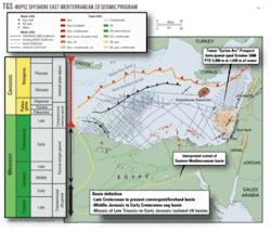
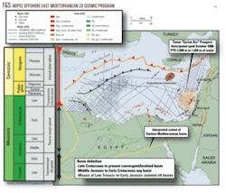
The onshore and offshore portions of the Eastern Mediterranean basin (Fig. 1) have proven to be a prolific hydrocarbon producing area. As of December 2006, oil reserves are 15 billion bbl and gas reserves are 100 tcf.
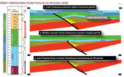
The tectonic evolution of the basin is interpreted to have proceeded through the following five stages:
- A Late Triassic to Early Jurassic transtensional rift period.
- A Middle Jurassic to Early Cretaceous sag period.
- A Late Cretaceous to Early Paleogene alpine inversion period.
- A Late Paleogene to Miocene internal plate adjustment period.
—Oligo-Miocene Gulf of Suez rifting.
—Miocene Red Sea rifting.
—Messinian salinity crisis. - A Pliocene flood period.
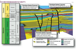
The basin’s hydrocarbon reserves are broadly distributed within three proven petroleum systems (Fig. 2) recognized within the EMB:
- Petroleum System A.
—Late Cretaceous-Eocene inversion structural play (referred to regionally as “Syrian Arc” folds).
—Middle Jurassic limestone and Early Cretaceous sandstone reservoirs. - Petroleum System B.
—Oligo-Miocene incised valley/submarine canyon structural/stratigraphic play.
—Oligo-Miocene sands deposited within the incised valley/submarine canyons. - Petroleum System C.
—Basal Pliocene-Pleistocene stratigraphic/structural play.
—Basal Pliocene turbidite sandstone reservoirs offshore Gaza Strip and offshore Israel.
—Mid-Pliocene to Pleistocene turbidite sandstone reservoirs offshore Egypt.
Important general phenomena observed associated with the distribution of hydrocarbons through the stratigraphic column include the following;
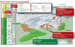
- There exists a distinct lightening-upward of the hydrocarbon phase from oil and gas in Petroleum System A to gas, oil, and condensate in Petroleum System B to mainly very light gas (mainly methane) occasionally associated with condensate (Fig. 3).
- With the historical shift in drilling from initial onshore and near offshore focus on Petroleum System A and Petroleum System B, the EMB was perceived as an oil and oil/gas prone basin. With the large success of offshore Petroleum System C, the more distal portion of the EMB is generally regarded as gas-prone.
- All Plio-Pleistocene gas and gas/condensate discoveries are proximal to deep-seated, near vertical paleofaults that extend through the entire stratigraphic column.
- Importantly to the petroleum systems in the distal portion of the EMB, operators and service companies have reported water-bottom oil seeps associated with these deep-seated, near vertical paleofaults that cut upward to the water bottom interface from the Mesozoic section through the entire Cenozoic section (inclusive of the Messinian Salt and overlying Plio-Pleistocene section (Fig. 3).
In spite of the impressive scale of the hydrocarbon reserves within the EMB, the distal portion of the basin remains underexplored.
Between 2001 and 2005, TGS-NOPEC Geophysical Co. acquired the nonexclusive Eastern Mediterranean basin 2D seismic database that consists of 19,256 km of new shoot 2D seismic data off Lebanon, Israel, and Egypt (Fig. 1). The company also reprocessed to merge with the new acquisition 4,526 km of existing EGAS offshore Egypt vintage seismic data (Fig. 1).
Importantly, the TGS-NOPEC Eastern Mediterranean basin 2D seismic database tied all preacquisition deep offshore wells (penetrated into the Mesozoic section). Those preacquisition offshore deep wells are all relatively near the shoreline of Egypt and Israel.
As onshore in the Egyptian Western Desert and northern Sinai Peninsula and the Israeli coastal plain, these preacquisition offshore deep wells commonly targeted large inversion structures (Petroleum System A: “Syrian Arc” folds) that were “squeezed up” from paleo-lows during strong, abrupt transpressional episodic pulses during the Late Cretaceous-Eocene period (Fig. 4). The stratigraphic section penetrated in these offshore “Syrian Arc” wells consists of a thick Mesozoic section under a thin Pre-Messinian Tertiary section. Middle Jurassic limestone or Early Cretaceous sandstones reservoirs in these offshore “Syrian Arc” wells frequently exhibit oil and gas shows or tested oil generated from mature Middle Jurassic and Early Cretaceous source rocks.
With the exception of one well (the Total Mango-1 well drilled in 1985 off the Sinai Peninsula), all other pre-seismic acquisition, deep offshore wells are separated from the distal portion of the EMB by extreme structural (prominent structural ridge offshore Israel) or stratigraphic (deep incised valley/submarine canyon complexes offshore western Egypt) obstructions and, thus, these deep wells do not provide reliable extrapolation with confidence of well ties along seismic lines to the distal portion of the EMB.
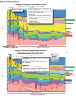
Previous attempts to extrapolate horizons along seismic lines tied to formation tops encountered in these proximal deep offshore wells to the distal portion of the EMB have been greatly influenced by these structural or stratigraphic obstructions. The prevailing interpretational paradigm has been to “drop down” along normal faults on the distal side of these obstructions. This “drop-down” interpretation has resulted in prevailing perspective that the distal portion of the EMB is widely interpreted to be dominated by a very thick Oligo-Miocene section (2-3 sec (TWT) thick) overlying a thin, deeply buried Mesozoic section (Fig. 5a).
Burial histories constructed on pseudowells utilizing the thick Oligo-Miocene section over a thin, deeply buried Mesozoic section predict:
- Known onshore/proximally offshore Early Cretaceous/Middle Jurassic source rocks are too thin, too deeply buried, and overmature to provide hydrocarbons to the overlying sections.
- The Paleogene/Neogene section is thermally immature and only capable (if source rock potential exists) of generating biogenic gas into the available Tertiary reservoirs.
Due to the above interpretational paradigm combined with the predominance of light gas in the Plio-Pleistocene traps, the distal portion of the EMB is therefore regarded near universally as a gas (methane-dominated) province.
However, several unusual aspects of this prevailing interpretational distal EMB paradigm of a distal, thick Oligo-Miocene section over a thin, deeply buried Mesozoic section are as follows:
- The interpretational paradigm contrasts starkly with the known stratigraphic section in all the deep offshore wells of an overlying thin Oligo-Miocene section dominated by a thick Mesozoic section.
- The interpretational paradigm strongly implies a sudden, extreme Oligo-Miocene extensional tectonic phase as considerable accommodation space is required for the sudden 2-3 sec (TWT) expansion of the Oligo-Miocene section. This need for sudden expansion (and implied extension) again is in stark contrast with the known tectonic evolution that shows that the EMB was under continued compression from Late Cretaceous (initial collision of the northern Eurasian plate with the southern African/Arabian plates) to the present.
- Where a biogenic-gas generating petroleum system is predicted, water bottom oil seeps are reported in the distal portion of the EMB associated with deep-seated, near vertical paleofaults.
Deep Seek Exploration Experts LLC interpreted all the TGS-NOPEC Eastern Mediterranean 2D seismic database off Lebanon, Israel, and Egypt.
From the proximal deep well control to the distal portion of the EMB, this Deep Seek Exploration interpretation was uniquely accomplished by the following methodology:
- Unlike previous “drop-down” interpretational attempts to extrapolate horizons distally, Deep Seek interpreted the TGS-NOPEC Eastern Mediterranean 2D seismic database from “bottom up.”
- Deep Seek Exploration constrained the interpretation firmly within the basin’s known tectonic evolution framework.
- The EMB Triassic-to-present stratigraphic section is punctuated by two major megatransgressive periods including the Middle-to-Late Jurassic period and the Senonian-to-Eocene period. On seismic lines through deep offshore control wells, the end of each of these megatransgressive periods are marked by two thick seismically transparent (implying homogeneous lithology) units dated in the control wells as 1) Late Jurassic and 2) Latest Cretaceous to Eocene. Therefore in the distal portion of the EMB, the deepest seismically transparent unit is dated Late Jurassic while the shallowest seismically transparent unit is dated the Latest Cretaceous to Eocene.
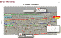
Fig. 6 is the Deep Seek Exploration Experts’ “bottom-up” interpretation of the TGS-NOPEC line 2069-IS. The pre-Messinian salt interpretation was accomplished through the following “bottom-up” steps:
- Step 1: Identification of the Triassic-Early Jurassic rift ztage base/rift horizon (red).
—This horizon is identified by onlap of seismic events (synrift) onto subparallel obliquely inclined prerift seismic events. Over the distal portion of the EMB, confident identification of this horizon ranges from poor-good. - Step 2: Identification of the base/Cretaceous horizon (blue).
—This horizon is identified by being directly above the deepest seismically transparent unit interpreted as a Late Jurassic section of homogeneous hemipelagic mudstone deposited within paleo-lows during the maximum extend of the Jurassic megatransgression. - Step 3: Identification of Top/Albian horizon (yellow).
—This horizon is identified by the first (from bottom-up) episodic “punch-up” or inversion of paleolows. Syn-inversion seismic events directly over this “punch-up” would onlap the Top/Albian horizon. The overlying syn-inversion section would thin over the structure and thicken off-flank of the structure.
The Deep Seek Exploration Experts’ “bottom-up” constrained interpretation of the distal portion of the EMB utilizing the TGS-NOPEC Eastern Mediterranean basin 2D seismic database has the following consequences:
- The distal portion of the Eastern Mediterranean basin is interpreted to be dominated by a thick Mesozoic section under a thin Pre-Messinian Tertiary section (Fig. 4b).
- The interpretation of burial histories performed on pseudowells with thick Mesozoic section under a thin Pre-Messinian Tertiary stratigraphic sections (show that the distal portion of the EMB, like the known onshore and proximally offshore, is not a biogenic gas province but an oil province.
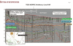
The significant exception to the previously mentioned extrapolation dilemma (horizons tied to well formation tops extended into the distal portion of the basin) is the Mango-1 well that was drilled offshore Sinai Peninsula by Total in 1985. The Mango-1 well targeted the crest of a large offshore Syrian Arc fold (inversion structure, Petroleum System A) and tested 10,000 bo/d from a number of thin Albian/Aptian sands. Total drilled the Mango-2 well along approximate structural strike but failed to penetrate correlative, productive sands to those that tested oil in the Mango-1 well. With the failure of the Mango-2 well, Total subsequently abandoned the project. Importantly, the Mango structure is located on the basinal side of a large structural ridge. TGS-NOPEC programmed the acquisition of the NW-SE trending line 5130-EG to tie the Mango-1 well. Along this line, horizons tied to the Mango-1 well formation tops can be extrapolated with a good confidence into extreme distal portion of the Basin (Fig. 7) and tie to the “bottom-up” line 2069-IS (Fig. 6). This Mango-1 extrapolation into the distal portion of the EMB not only was utilized as a constrain on the “bottom-up” interpretation but helped support the interpretation that the distal portion of the EMB is oil-prone.
Exceptionally large four-way dip structural traps (100 sq km to over 1,500 sq km) have been mapped within drillable depths (generally less than 1 sec TWT below the base/Messinian salt) throughout the distal portion of the basin (offshore Lebanon, Cyprus, Israel, and Egypt). The “bottom-up” interpretation utilizing the TGS-NOPEC Eastern Mediterranean basin 2D seismic dataset predicts that these large structures are Petroleum System A inversion structure. If as suggested by burial histories executed on distal pseudowell location on the “bottom-up” interpretation and supported by the presence of distal water bottom oil seeps along deep-seated paleofaults, giant-to-supergiant accumulations of oil may be trapped within Early Cretaceous sandstone reservoirs contained by these distal “Syrian Arc” inversion structures.
The concept will soon be tested.
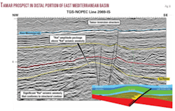
Noble Energy Inc. will spud the Tamar-1 well as early as October 2008 in the distal portion of the EMB (Fig. 8). The well will target a large (250 sq km), asymmetrical, NE-SW trending pre-Messinian salt four-way dip structure. Seismic amplitude anomalies including a “flat” amplitude anomaly at approximate structural spill-point with a high-amplitude seismic package above the “flat” event further enhancing the prospectivity of the large Tamar structure (Fig. 6 (close-up of Fig. 5)).
The “bottom-up” interpretation utilizing the TGS-NOPEC Eastern Mediterranean basin 2D seismic dataset would conclude the following concerning the Tamar structure:
- The NE-SW trending asymmetrical four-way dip structure is a very large Syrian Arc fold (inversion structure (Petroleum System A).
- The “flat” seismic anomaly with overlying “hot” seismic package is directly below the Top/Albian horizon and is interpreted as associated with an Albian turbidite sand unit.
- The “flat” seismic anomaly with overlying “hot” seismic package is directly below the Top/Albian horizon and is interpreted as an oil-filled Albian sand reservoir unit with good porosity and permeability above an oil/water contact.
The author
James M. Peck ([email protected]) is president of Deep Seek Exploration Experts LLC in Houston. He has been involved since 1975 in exploration in the Gulf of Mexico, West and North Africa, the Middle East, and Southeast Asia. For the last 10 years, he has focused on the Eastern Mediterranean basin and has interpreted more than 28,000 line-km of 2D seismic data over the offshore portion of the basin. He has a BS in geology from the University of Houston.
