New exploration concepts highlight Columbia River basin’s potential
Rising demand for natural gas in the US and an uncertain outlook for imports make the search for new domestic reserves both urgent and economically attractive. Few regions of the world are as extensively explored as the lower 48 states, yet there remain a small number of frontier areas of the first rank with proven hydrocarbon potential.
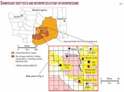
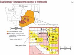
Among these, the most underexplored by far is the Columbia River basin (CRB) of south-central Washington State (Fig. 1). This 60,000 sq mile province, larger than most Rocky Mountain basins, is also unique in geologic character, complexity, and gas prospectivity.
It was the target of important, if intermittent, industry interest from the 1950s to the 1980s, when several companies led by Standard of California and Shell drilled a remarkably courageous series of deep wildcats attempting to penetrate thousands of feet of basalt in hopes of encountering thick Eocene reservoirs beneath.
Now, a new round of activity is under way. The first phase of this activity involved three deep tests, drilled between 2005 and 2007 by EnCana Corp., providing important confirmation of basin potential and adding significantly to understanding of the CRB. The next phase of work, currently in progress, involves an impressive technical effort spearheaded by Exxel Energy Corp. of Houston. Results of these efforts not only justify further drilling but reconsideration of two older wells as possible reentry candidates.
The present article is intended to summarize some of the ideas and information that contribute to this conclusion. As such, it is aimed at updating previous publications on the hydrocarbon potential of the basin,1 2 including the author’s own.3 The writing of this report has benefited greatly from selected access to data provided by Exxel Energy, a major participant in the CRB play.
Exploration history
The current round of drilling represents only the second time modern exploration methods have been applied to the CRB.
During the 1980s, Shell, Meridian, Arco, Chevron, Exxon, and several independent operators were involved in detailed study of the province. Their analyses, based on surface mapping in surrounding areas, as well as data from a few older wells plus seismic, gravity, and magnetotelluric (MT) surveys within the CRB proper, yielded a preliminary basin model.
Several key aspects of this model are worth reviewing. Shell et al. verified the existence of three graben-like subbasins filled by Eocene fluvial deposits (Swauk/Manastash/Herren and Roslyn/Naches/Chumstick formations) and Oligocene volcanogenic and siliciclastic rocks (Ohanepechosh and Wenatchee formations, respectively), overlain by Miocene flood basalts. Thickness of the basalt was difficult to predict at the time, but data strongly suggested it increased substantially into the subbasin lows.
Major structures included basement horsts and long, narrow, late-stage folds (Yakima fold belt) bounded by shallow thrust faults that appeared to steepen with depth. Based on field study, reservoir quality was expected to be highest in the Swauk and possibly the Roslyn intervals. Surface structures were interpreted to continue at depth. The model did not incorporate the possibility of a basin-centered gas accumulation, as this concept was not yet articulated.
Shell and partners drilled eight wells, mainly to test Yakima fold belt structures. Five of these penetrated into the prospective Tertiary reservoir section. Two wells, the Shell Western Yakima Minerals 1-33 and BN 1-9 (Fig. 1), tested significant flows of gas. The BN 1-9, in particular, produced up to 5.1 MMcfd and 6 b/d of condensate over a 62-day period. Both wells indicated many zones in the Eocene-Oligocene section with significant sand development and gas potential, based on mud and well log information. Both were deemed noncommercial and abandoned due to a combination of low gas prices, high drilling costs, and lack of gas transport options.
The three recent tests (Fig. 1), drilled by EnCana in varying partnership with Shell, Delta Petroleum, Exxel, and Netco, apparently targeted Roslyn on basement uplift and thrust-related structures as well and were guided in part by exploration concepts developed by Savant Resources LLC.
The Brown 7-24 apparently intended to test a large basement feature, while the Anderson 11-5 and Anderville Farms 1-6 seem to have had objectives in deeper, fault-related traps below 12,000 ft. Detailed results of these wells remain proprietary, yet several comments may be made on the basis of information recently released by Delta Petroleum:4
- The Brown well encountered its target but penetrated a considerably thinned Roslyn and Swauk section before bottoming in basement;
- The Anderson penetrated a significantly thickened basalt cover and did not reach its intended target; and
- The Anderville test may have been in an off-structure position.
These results highlight three facts.
First, like most of Shell’s program in the ‘80s, none of these wells succeeded in completely evaluating the concepts on which they were based. Downdip potential on the Brown feature, for example, may be the reason that Exxel assumed control of this well.
Second, exploration in the CRB remains at an early but critical stage. Explorationists face significant challenges related to predicting the depth, extent, and structure of the subbasalt section.
Third, geoscientific analysis of a high order, combining all forms of available data, is required to resolve the petroleum system operating in the basin.
At present, large parts of the CRB are under lease. Major players involved in the basin remain Shell, EnCana, Exxel, Delta, Trident Energy, Savant Resources, and Netco. Delta has permitted two wells for future drilling, the Gray 31-23 and McBride 28-13, both located in a portion of the CRB, south of the Pasco subbasin, without any previous deep tests and distant from outcrop exposures.
According to Delta,4 the Gray well targets an anomaly defined in part on the basis of magnetotelluric data. This anomaly is interpreted to thin the basalt cover by 50% and create about 5,000 ft of local structural relief. Exxel Energy, meanwhile, has identified a series of prospects in the northern CRB, located over basement highs and thrust closures.
Exploration concepts
A large team of geoscientists assembled by Exxel Energy has developed an updated and evolving basin model for the CRB.
This model has benefited from innovative methods that integrate gravity, magnetic, and seismic data (reflection and refraction) and that incorporate exhaustive geologic and geochemical studies based on outcrops around basin margins and hundreds of wells drilled in both eastern and western Washington (many wells in western Washington penetrate the identical Tertiary stratigraphic sequence as exists in the CRB).
The result, compared with interpretations based on only one or two data types (e.g., MT and well correlations) is a greatly enhanced ability to image and characterize the subbasalt section. Improved delineation is now possible of such key parameters as basalt thickness, subbasin geometry, structural style, burial history, and reservoir distribution.
Exploration concepts that emerge from Exxel’s recent work firm up earlier interpretations and also reveal some surprises. A selection of related concepts would include the following:
Reservoirs
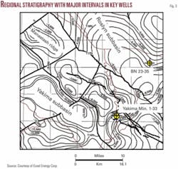
The primary target reservoirs are the Eocene Roslyn formation and equivalent rocks. Secondary objectives include the underlying Swauk/Manastash and Teanaway formations, as well as the overlying Oligocene Wenatchee (Fig. 2). The Roslyn represents deposition by low-gradient meandering streams that traversed peat swamps. Sandstones of both distant and local provenance often contain coaly material and are interbedded with carbonaceous shales and coal beds, thus creating reservoir/source rock “couplets.”
In the deeper parts of the Yakima and Pasco subbasins, sandstones have little remaining pore space due to extensive diagenesis (quartz overgrowths, authigenic clays, and zeolites). Gas-bearing sands closer to basin flanks and on structure retain porosities of 10% or more. Migration of gas into these sands is interpreted to have inhibited the later stages of diagenesis, preserving porosity.
Wenatchee sands are mixed fluvial and volcanogenic deposits that have also been subjected to significant alteration. In the BN 1-9 well, however, gas is present in thin (5-20 ft) sands below 12,500 ft depth, again suggesting that migration was an important inhibiting factor on diagenetic processes.
The Teanaway is a nonmarine, volcaniclastic unit at the base of the Roslyn that appears to have tested gas and very high volumes of water in the Yakima 1-33 well over a thick perforated interval. In the central and southern portions of the CRB, net sandstone in the Roslyn alone averages 2,100 ft, testifying to a very large gas resource.
Structural style
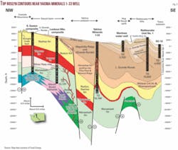
Three types of dominant structures exist: horst-like basement uplifts; a system of NW-SE dextral, oblique-slip faults; and a set of east-west folds commonly bounded by low-displacement thrusts. A number of basement uplifts and also the boundaries of subbasin lows are defined by the NW-SE fault system and its weaker NE-SW conjugate set (Fig. 3).
Thrusted folds in the basalt have a complex, variable relationship to structures at depth. In some areas, thrusts are detached, while in others they may be rooted in older, basement faults. In general, it is now speculated that much of the basalt cover responded as a separate structural entity relative to the underlying sedimentary section. New analysis of seismic and other data suggests that ramp-type geometries are prevalent in certain parts of the basin (Fig. 4).
These interpretations, which revise previous ideas of basin structure, highlight new kinds of prospects, including those where conventional traps and the basin-centered accumulation may be superimposed. Despite the existence of brecciated basalt at the surface, faults are interpreted to be sealing at depth within the Tertiary section, based on analogy (e.g., to Oregon’s Mist field). Base of basalt is reliably predicted from a combination of integrated geochemical stratigraphy, gravity and magnetic data, well correlations, and mapping of individual flow geometries within the basalt section.
Trap types
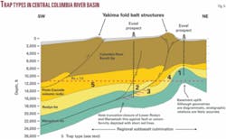
As suggested by Fig. 5, there are a minimum of five trap types in the CRB. These include:
- Basement highs.
- Thrust-related closures.
- Subthrust (upturned) beds.
- Reservoir pinchout/truncation along the flanks of highs.
- Basin-centered gas accumulation (overpressure cell).
Of these types, the most prospective are interpreted to be 1, 2, and 5. A number of mapped closures are considerable in size (>10 sq miles) and may rank among the largest untested structures in the western US. Regional cross sections through the CRB show that some basement uplifts lie within the overpressure cell, while others extend above it.
Roslyn and equivalent rocks are erosionally thinned significantly over many of these highs. Thrust-related and pinchout traps in Roslyn and Wenatchee intervals can also occur within the zone of overpressuring.
Gas distribution
It is well-known that gas is widespread in aquifers and water wells across the CRB. Older basin models interpreted such gas to have a biogenic or thermogenic origin within the basalt sequence. Isotopic analysis by Johnson et al., however, has helped establish a deep, coalbed source.5
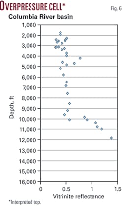
At the same time, geochemical study of rock samples recovered from subbasalt tests in the basin, as well as mud weights, drillstem test data, and other information, together suggest the existence of a large overpressure cell in the basin.6 Over much of the CRB, this cell corresponds with gas occurrence in low-permeability Roslyn and, to a lesser extent, Wenatchee sands and is thus interpreted to represent a basin-center accumulation. As shown by Fig. 6, top of this accumulation corresponds to a vitrinite reflectance of Ro = 1.0 and depths of around 11,000 ft.
Burial history
Improved characterization of the subsurface allows for better understanding of geologic history and gas generation in the CRB.
It is apparent, for example, that Swauk and lower Roslyn sediments were deposited over a vast, westward-draining plain. This plain was subjected to deformation in Eocene-Early Oligocene (upper Roslyn) time, when oblique plate convergence and proto-Cascade volcanism generated NW-SE and NE-SW oriented faults and began segmentation of the CRB into the Pasco, Yakima, and Richland subbasins.
Rapid downdropping and filling of subbasin depocenters took place through the Oligocene, such that, by the time flood basalt extrusion began (17 m.y.), Roslyn coals and carbonaceous shales were in the early stages of gas generation.7 A shift to north-south compression, coeval in part with the later stages of extrusion, generated the thrust-bound structures of the Yakima fold belt and continued subsidence in subbasin lows. Migration of gas into conventional traps and into low-permeability Roslyn and Wenatchee sandstones reached a maximum during the Mid-Late Miocene and continues today.
Taken together, these concepts strongly support the need to apply contemporary techniques of well completion in tight gas sandsspecifically, multistage frac stimulationto the Roslyn within the overpressure cell. Such techniques have proven enormously successful in unlocking the multi-tcf reserves of the well-known Jonah and Pinedale fields of the Green River basin, Wyo.
Indeed, like the CRB, neither of these giant fields was commercial during the first several decades of related exploration. Potential at Pinedale, in particular, had long been recognized in thick sequences of gas-bearing fluvial sands and shales of the Late Cretaceous Lance formation but had to wait for modern completion methods to be realized.
Multistage frac treatments, by which several stages of a reservoir can be stimulated in fairly rapid succession, has opened new production in many tight formations of the US, including the Lance, Mesaverde, Barnett shale, and Bakken formations.
Redrill candidates
To date, log and test data are available from six deep wells in the CRB. Among these, five had flows of gas, mainly from sands in the Roslyn and Wenatchee formations.
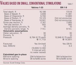
In only two of these wellsthe Yakima 1-33 and BN 1-9 (see Fig. 1 for locations)were stimulation and acidization applied to the Roslyn. These stimulations were small in scale and conventional for the time. Nonetheless, both wells yielded flow rates that would be considered commercial in most hydrocarbon basins. A summary of information from these wells is shown in Table 1.
The Yakima 1-33 was drilled at the intersection of an identified subbasalt thrust structure and northwest-trending horst and penetrated a large portion of the Wenatchee-Roslyn section (TD = 16,199 ft). Most of the Roslyn section at this location is within the overpressure cell, revealed by a gradient of 0.75 psi/ft at 11,700 ft.
Log analysis indicates a total of 35 potential reservoir zones, totaling 1,481 net ft (502 ft with maximum potential). Only 12 zones were tested, with a small frac (77,000 lb of proppant) applied to several sands at 12,350-460 ft depth, establishing a flow of 500 Mcfd. All nonstimulated zones produced smaller amounts of gas with little or no water.
The well also tested 570 Mcfd and 5,400 bbl of water from a thick zone (no frac) that included a significant portion of the Teanaway formation, indicating high permeability possibly due to fracturing. A new well drilled to intersect most or all of these zones, plus the Teanaway zone above the gas/water contact, defines a quality prospect in this vicinity.
In the BN 1-9, the intended target was a thrust-bound closure in a deeper part of the basin. At this location, the basalt cover is 11,500 ft thick; thus both the Wenatchee and Roslyn formations occur within the zone of overpressure. The well reached TD at 17,518 ft and did not encounter the base of the Roslyn.
Examination of log data in comparison with that from wells in producing tight gas plays, such as the Pinedale anticline, suggests between 550 ft and 750 ft of potential net pay. Using conventional analysis, Shell identified 15 prospective sands, with 157 net ft, and tested a total of 11 zones (107 ft). Only two of these zones received fracs: one zone, in the lower Wenatchee (~12,800 ft), flowed 2.4 MMcfd; the other, in the Roslyn (~13,380 ft), yielded a rate of 3.1 MMcfd with 6 bbl of 30.2° condensate, with 3,965 psi flowing tubing pressure.
Core information on this deeper Roslyn zone indicated 7% porosity and 0.4 md permeability. Several of the more prospective zones, particularly within the Wenatchee, were not tested in this well.
Both of these wells demonstrate large volumes of producible gas. Given that they were stimulated with 1980s techniques on isolated intervals, it is reasonable to assume that much higher flow rates would have resulted if larger, multistage fracs were applied to a majority of prospective zones in each well. In one estimation, rates at the BN 1-9 could have exceeded 10 MMcfd had such stimulation been applied at the time.8
It is for these reasons that the two wells are currently under serious consideration for either reentry or offset. Specifically, depending upon hole conditions, the BN 1-9 presents a reentry opportunity, whereas the Yakima 1-33 would likely be offset, due to the large amount of water in the Teanaway.
Reserves estimates
Based on data from these two wells, plus that from the other four subbasalt tests, resource and reserve estimates can be made.
One set of such estimates was generated in 1995 by Advanced Resources International Inc. (ARI), a research and consulting firm specializing in unconventional reservoirs.8 Its figures provide an informative third-party assessment.
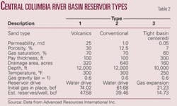
ARI defined three basic reservoir types: porous/permeable volcanics (e.g., Teanaway formation); conventional sandstones; and tight gas sandstones. Parameters chosen for each reservoir type are shown in Table 2.
It should be noted that the tight sand reservoir type was not assessed on the basis of an identified basin-centered gas accumulation, since this interpretation had not yet been accepted for the CRB, and was posited at a shallower depth (10,000 ft). As a result, the estimate for this type should be considered below an appropriate minimum.
Recovery efficiencies were set at 64% for reservoir types 1 and 2 and at 69% for type 3 (tight sands), based on analogy to known reservoirs of similar composition. As shown, estimated per-well reserves for the different reservoir types range from about 15 to 48 bcf.
Gas-in-place figures supplied by Exxel Energy, meanwhile, calculated on the basis of data from the Yakima 1-33 and BN 1-9, specifically, are given in Table 1 (bottom portion) and can be compared with those of Table 2. Table 2 figures, which combine all reservoir types for each well, are considerable in size. At 69% recovery, they yield reserves of 25 bcf/80 acres for the Yakima well and 33 bcf for the BN 1-9.
These figures closely match those recently cited by Delta Petroleum for the BN 1-9 (30 bcf for 80 acres).4 The scale of these numbers is directly tied to the large thickness of net pay (>500 ft), identified on the basis of integrated log and test data. It is to be noted that both Delta and Exxel report prospects ranging in size from 20,000 to 65,000 acres.
Risks and rewards
While the CRB offers huge potential, it remains a uniquely challenging province. Several primary risks, noted in the past, are apparent today as well. These include difficulty in accurately imaging the subbasalt section, mechanical uncertainties and high costs of drilling, and unknown reservoir performance.
As discussed, the first of these risks has been significantly reduced by contemporary geoscientific methods. Drilling uncertainties, related especially to the basalt and underlying volcanogenic Oligocene section, now appear under control, due to the successful approach adopted by EnCana at its three recent wells, employing reverse circulation.9 Costs, however, remain significant. Risks related to reservoir performance, meanwhile, cannot be evaluated without actual production.
Exploration in the CRB may be at a critical stage. Relevant data indicate a large-scale gas resource in the basin, yet commercial production remains to be established. Further lack of success would likely dampen future drilling.
Yet the first well to achieve economic production would open a new chapter, not only for this unique frontier province, but, quite likely, for gas supply in the western US. In an era of elevated gas prices, the Columbia River basin may yet give new meaning to the old adage that claims exploration as a frequent drama of refound opportunity.
Acknowledgment
The author acknowledges Exxel Energy’s exploration team for contributions to my understanding of the basin and this article. Their team includes Steve Boyer, Steve Reidel, Dale Bird (Bird Geophysical), Tony Gale, Eric Budsberg, Karen Christopherson (Chinook Geophysical), Paul Hammond, Robert Klipping, Ben Law, and Bill Lingley. I also thank Tim Walsh of the Washington Department of Natural Resources.
References
- Johnson, Samuel Y., Tennyson, Marilyn E., Lingley, William S., Jr., and Law, Ben E., “Petroleum geology of the State of Washington,” US Geological Survey Professional Paper 1582, 1997, 40 pp.
- Lingley, William S., Jr., “Petroleum potential and probability of renewed mineral-rights leasing in the Columbia Basin, Washington,” Washington Department of Natural Resources, 1995, 43 pp.
- Montgomery, S.L., “Investigating the Potential of the Pacific Northwest,” Petroleum Frontiers, Vol. 2, No. 4, 1985, 75 pp.
- Corporate presentation, Delta Petroleum Corp., Dec. 13, 2007 (www.deltapetro.com).
- Johnson, V.G., Graham, D.L., and Reidel, S.P., “Methane in Columbia River Basalt aquifers: Isotopic and geohydrologic evidence for a deep coal-bed gas source in the Columbia Basin, Washington,” AAPG Bull., Vol. 77, 1993, pp. 1,192-1,207.
- Law, B.E., “Columbia BasinBasin-Centered Gas play 0503,” in Tennyson, M.E., “Eastern Oregon-Washington Province (004),” in Gautier, D.L., Dolton, G.L., Takahashi, K.I., and Varnes, K.L., “1995 National assessment of United States Oil and Gas ResourcesResults, Methodology, and Supporting Data,” US Geological Survey Digital Data Series DDS 30, 1995, 1 CD-ROM.
- Walsh, T. J., and Lingley, W.S., Jr., “Coal maturation and the potential for natural gas accumulation in western and central Washington State,” in Salisbury, G.P., and Salisbury, A.C., eds., Fifth Circum-Pacific Energy and Mineral Resources Conference transactions, Gulf Publishing Co., 1996, pp. 667-685.
- “Engineering Evaluation of Potential Production from Deep Columbia Basin Wells, Washington,” report prepared by Advanced Resources International Inc., Nov. 29, 1995.
- Rach, Nina M., “Custom-built rig uses reverse-circulation pipe to drill basalt,” OGJ, June 11, 2007 (Vol. 105, No. 22), pp. 53-57.
The author
Scott L. Montgomery ([email protected]) is a petroleum consultant, author, and adjunct faculty member in the Jackson School of International Studies, University of Washington. He has written widely on frontier exploration plays and issues, particularly in North America, and is completing a book on energy issues in the 21st century. His most recent book is “The Chicago Guide to Communicating Science,” University of Chicago, 2003. He has a BA in English from Knox College and an MS in geological sciences from Cornell University.
