This is the second of two parts on oil and gas exploration in the Jiuxi basin in northwestern China.
Exploration started in the basin in 1938.
The basin has one of China’s earliest commercial oil discoveries and is considered the cradle of the Chinese petroleum industry.
By the end of 2003, 540 exploratory wells had been drilled, with a density of 0.2 well/sq km. Six oil fields-Laojunmiao, Yaerxia, Shiyougou, Baiyanghe, Shanbei, and Qingxi-were discovered in succession. The reservoirs are Silurian, Cretaceous, and Tertiary. Discovered reserves are 148 million tons of oil, and the present production is 700,000 tons/year.
Oil exploration in basin came in three stages from 1932-82, 1983-96, and 1997-present.
Structure exploration stage
This stage lasted from 1932 until 1982.
As early as 1938, exploratory wells were drilled on the Laojunmiao anticline along the river valley on the foothills of the Qilian Mountains, which were surveyed at the surface by Mr. Sun Jianchu and others.
In August 1939, the Tertiary Laojunmiao oil field was discovered by drilling the Lao-1 exploratory well, kicking off petroleum exploration and development in the Jiuquan Region.
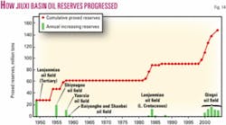
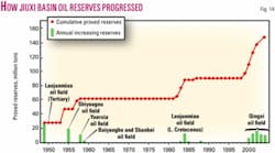
In 1949, cumulative proved reserves reached 27.66 million tons and production was 69,200 tons/year (Figs. 14 and 15). In the 1950s, exploration continued along the anticline belt and consequently, Yaerxia and Oil Gully Tertiary oil fields were found; and the Tertiary Baiyanghe and Shanbei oil fields were discovered in the Baiyanghe thrust belt in the northern part of the basin. At the end of 1959, cumulative proved reserves reached 61.61 million tons and production was 1.4 million tons/year, at its historical peak.
From the 1960s to the early 1980s, little prospecting progress was made. Two small pools were found in faulted Block 701 and 881 in the Cretaceous and Silurian basement in Laojunmiao and Yaerxia oil fields, with 26.86 million tons of reserves proved. This increased cumulative proved reserves by only 16.36 million tons. Thus, oil production fell sharply from 1.09 million tons in 1960 to 0.406 million tons in 1965. Thereafter, the annual production stayed around 0.40-0.60 million tons.
In this stage, exploration targets were traps configured by the uplifts and surface structures; and oil-bearing rocks were fractured Tertiary and partly Cretaceous and Silurian.
Source depression stage
This exploration stage lasted from 1983 to 1996.
In the late 1970s, exploration on the uplift belt and Tertiary formations in the Jiuxi basin was unsuccessful, resulting in a steady decrease in reserves and low oil production for a long time. The severe situation forced petroleum geologists to shift hydrocarbon prospecting from uplift areas to oil-source depressions with the idea of hydrocarbon kitchens controlling the oil reservoirs distribution.
In 1983, the first well, Xican-1, was drilled in the Qingxi Depression to a depth of 4,570 m. It discovered more than 1,000 m of high-quality Lower Cretaceous source rocks. In addition, oil-bearing formations were discovered in the Lower Cretaceous lacustrine shaly siltstones and shaly dolomites.
Well-log interpretation identified two oil-bearing intervals, total 124 m thick; and a formation test produced oil at 7 cu m/day. Yumen Oilfield Co., in cooperation with GSI of the US, introduced digital seismic prospecting technology in 1985 and shot five lines totaling 209.46 km of 2D seismic survey along gullies at both southern and northern edges of the Jiuxi basin and identified large-scale overthrust faults at the northern edge of the Qilian Mountains.
However, it was uncertain whether Mesozoic strata and structures were present underneath the thrust fault due to poor seismic imaging. Until 1988, only three out of nine wells had low oil flow in the “synclinal” shaly dolomites in the Liugouzhuang area of the depression; and the 6 years of exploration in the Qingxi depression did not locate major discoveries. As a result, petroleum prospecting had been nearly suspended in the Jiuxi basin from 1989 to 1997.
The failure, however, did not defeat the confidence of Chinese geologists. From 1984 to 1986, Zhang Chuangan, Zhao Wenzhi, and others conducted detailed studies of the thrust belts in western China and pointed out that there are large thrust belts along the northern edge of the Qilian Mountains where great exploration potential exists on the basis of basin evolution.
The geologists of Yumen Oilfield Co. reevaluated the structures and gained practical understanding of the geological conditions and reservoir types in the thrust belt in the mountain front. The source rocks are rich and thick, with good potential of hydrocarbon generation and abundant hydrocarbon resources.
The Liugouzhuang and Kulongshan structures are located in the source kitchen area, having a fair oil accumulation condition as proved by three low oil flow wells. Reservoir rocks are highly heterogeneous and fractured. They also realized that formation damage is severe and reservoir protection must be strengthened during well completion, and a suite of well logging and stimulation techniques should be applied.
Mountain front stage
This exploration stage lasted from 1997 to the present.
In 1997, Yumen Oilfield Co. reactivated exploration in the Jiuxi basin. Seismic surveys resumed in hilly areas on the thrust belt at the northern edge of the Qilian Mountains, better defining the Kulongshan and Liugouzhuang structural belt.
In 1998, the Liu 102 well in the Liugouzhuang structure in the deep depression (Fig. 11) produced a 54 cu m/day commercial oil flow during formation test from the shaly dolomite of the Cretaceous Xiagou formation. Higher yield (126 cu m/day) was reached after acidizing.
A total of 105,000 tons of oil was produced in 2 years of trial production, and daily production had been above 140 tons/day with a tubing pressure at 5.6 MPa and a casing pressure at 7.6 MPa. The high pressure at high-yield level indicated a strong pressure drive.
Liu 102 was the first well at which production exceeded 100 tons/day in the Qingxi Depression and was the first well with high production discovered by Yumen Oilfield Co. for more than 10 years. It marked the beginning of exploration at the piedmont of the Qilian Mountains.
Furthermore, the L101 well encountered 207 m of total oil-bearing beds and produced 104 and 58 cu m/day of oil, respectively, after acidizing of two intervals in 1998.
Well L4 in the west of the Kulongshan structure produced 108 cu m/day of oil and an initial gas flow of 10,787 cu m/day from conglomerate reservoirs of the Xiagou formation in 1999. After acidizing, the initial production reached 253 cu m/day; and the production as of late 2006 was 86 cu m/day on a 5-mm choke with a tubing pressure at 9.8 MPa.
Well L4 proved that hydrocarbons accumulated in structural highs and, unlike the Liugouzhuang structure, the Kulongshan structure showed a new type of play in the sandy conglomerate reservoirs.
Further analysis of the Kulongshan structure indicates that structure is the main controlling factor (Fig. 12) and sandy conglomerates are fair reservoir rocks. Thus, exploration extended to the mountain front overthrust nappes.
In 2000, Well L8 was drilled at the Qilian Mountains where Silurian metamorphic rocks outcrop. At a depth of 1,325 m, the well penetrated through the Silurian and into the Cretaceous in the footwall of the nappe and encountered oil-bearing sandstones and conglomerates of the Xiagou formation.
Test production at the 4,056.9-4,148.3-m interval was 201 cu m/day of oil and 32,000 cu m/day of gas on a 5.5-mm choke with 19 MPa tubing pressure and 20 MPa casing pressure.
The L8 Well proved a large hydrocarbon accumulation in the Kulongshan structure at the footwall of thrust nappes in the Qilian Mountains. It was followed by a number of productive wells (>100 cu m/day each; Fig. 11).
By the end of 2004, proved reserves reached 57.5 million tons, possible reserves 28.07 million tons, and probable reserves 19.60 million tons. In Qingxi oil field, the proved reserves will likely exceed 100 million tons; and current production is 0.8 million tons/year.
Modern technology
Advanced and practical technology has played an important part in the successful exploration of Qingxi oil field.
Retrospectively, irrational selection and application of prospecting technology delayed the discovery of Qingxi oil field in the Qingxi Depression for 14 years.
Continuous summarization of exploration experiences for 6 years has gradually established four sets of matched prospecting technology suitable for the deep fractured complex reservoirs in the Kulongshan thrust belts, resulting in substantial prospecting performance.
The four sets of technology are seismic imaging and structural modeling, identification and evaluation of fractured reservoirs by imaging logging, near-balanced drilling and formation protection, and deep acidization, which are described in detail below.
Imaging and modeling
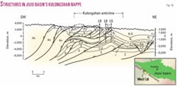
Geologists first established structural models based on field geological survey to further define the Kulongshan structure and recognized that the Kulongshan structural belt was a typical imbricate nappe (Fig. 16).
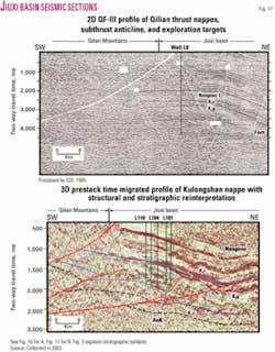
In 2000, seismic surveying in hilly areas was intensified and seismic imaging quality was greatly improved (Fig. 17), further confirming the existence of the Kulongshan structure.
In 2001, a 3D seismic survey was shot on the structure, better defining the deep Cretaceous structures at the footwall of the nappe.
Identification and evaluation
Rapid lateral facies changes in the Cretaceous posed a major technical challenge for reservoir identification and predication.
A set of approaches and procedures has been gradually established through practice to accurately identify fractured reservoirs.
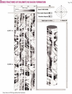
First, FMI logs are used to accurately identify complex reservoir lithologies (Fig. 18).
Second, CMR nuclear magnetic log (NML) and dipole shear sonic imaging (DSI) data are used to estimate the opening, permeability, and effectiveness of microfractures.
Finally, an FTI technique was used to determine and accurately divide oil, gas, and water layers in reservoirs.
The oil and gas production in a well is related to the characteristics of fractured reservoirs, which can be interpreted from signatures of imaging logs. Moreover, fracture development is controlled by small-throw (20-60 m) reverse faulting. The 3D attributes of small reverse faults can be comprehensively interpreted on 3D seismic profiles.
Ultimately, the relationship among small reverse faults, fractured zone, and oil-bearing formations can be established. As a result, exploration focusing on fractured zones has been increasingly successful. For example, 10 out of 14 exploratory and production wells in the Well L4-L5 block have a high yield of 100 tons/day, three wells a medium yield, and one well a low yield, with a 100% success rate. The average production of these wells is 60 tons/day, with combined productivity of 320,000 tons/year.
Formation protection
Kulongshan reservoirs have high formation pressure gradients ranging from 1.20 to 1.36, and serious formation damage will occur when drilling fluid pressure exceeds the formation pressure by 0.03 in gradient, as indicated by experiments.
During the drilling, therefore, drilling fluid density is strictly controlled and not more than 0.02 higher than the formation pressure gradient; no barite powder is used for well control; and a formation protection agent is added before drilling through the producing intervals.
The near-balanced drilling and formation protection technology has minimized formation damage. For example, barite powder was added many times to control Well L2 at the structural high of Kulongshan when a well kick occurred at a depth of 4,016 m. As a result, the well has a low oil yield of 4.13 cu m/day on formation test.
On the other hand, Well L5, which was drilled 253 m from Well L2, encountered the same situation at a depth of 4,029 m. In this case, near-balanced drilling and formation protection technology were applied and, as a result, high oil production was obtained.
Reservoir stimulation
Deep acidization is necessary to free hydrocarbons from the fractured reservoirs in Qingxi oil field to the maximum extent in order to substantially enhance production.
Deep acidization technology for shaly dolomite and conglomerate reservoirs has been developed through many rounds of experiments and has achieved excellent results. The increased oil production that resulted from deep acidization accounts for 36% of total production in Qingxi oil field.
Lessons learned
The discovery of Qingxi oil field and the successful oil prospecting beneath the nappes of the Qilian Mountains have not only revitalized 60-year-old oil fields but also demonstrated the great exploration potential of the foreland thrust belts abundant in central and western China.
Strengthened seismic surveys in the piedmont thrust belt of the Jiuxi basin has discovered a number of favorable prospecting targets beneath the nappe, such as the Jinhaizi, Qingtoushan, and Jinfomiao structures, since the discovery of Qingxi oil field. The total trap area reaches nearly 200 sq km, and the prospective oil resources exceed 230 million tons. Future exploration will certainly add many more reserves.
The discovery of Qingxi oil field has inspired hydrocarbon exploration in thrust belts in central to western China. In only a few years, many large gas fields have been discovered in the Kuche foreland of the Tarim basin, including wells Kela 2, Dina 2, and Wushen 1, and the recoverable gas reserves have reached 581.9 bcm.
At the southern edge of the Junggar basin, Hutubi gas field and Huoerguosi oil and gas field have been discovered, with proved, probable, and possible hydrocarbon reserves exceeding 200 million tons of oil equivalent.
In the Longmenshan piedmont thrust belt in the Sichuan basin, Qiongxi gas field has been discovered with gas reserves reaching 37.2 bcm.
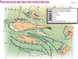
Also, productive oil and gas wells have been discovered in the northern thrust belt of the Tsaidam basin and the southwestern foreland thrust belt of the Tarim basin (Fig. 19). These discoveries indicate that the thrust belts in central and western China will become important regions for discovering large oil and gas fields in the future.
Recent Chinese evaluations indicate that the foreland basins in central and western China hold 4.1 billion tons of remaining recoverable oil and 6.99 bcm of gas, respectively, accounting for 18% and 45% of the total to-be-discovered oil and gas in China. Undoubtedly, overthrust belts are the key targets to discover hydrocarbon reserves in China in the future.
Acknowledgment
The research is sponsored by the National Basic Research Program (China) No. 2001CB209100 and is also the product of cooperation between RIPED and Yumen Oilfield Co. of PetroChina. We thank professor Desheng Li of RIPED for helpful comments; special thanks to Wan Yang, an associate professor in Department of Geology, Wichita State University, for his kind suggestion and modification in English writing. Seismic profiles and micrographs are courtesy of Yumen Oilfield Co.
References
- Macqueen, R.W., and Leckie, D.A., “Foreland basin and fold belts: an introduction,” in Macqueen R.W., et al., eds., “Foreland basins and fold belts,” AAPG Memoir 58, 1992, pp. 1-9.
- Mann, P., and Gahagan, L., “Classification of the tectonic setting of the world’s giant oil fields,” AAPG annual meeting, 2001.
- Pettingill, H.S., “Giant field discoveries of the 1990s,” The Leading Edge, Vol. 20, No. 7, 2001, pp. 698-704.
- Meissner, F.F., and Thomasson, M.R., “Exploration opportunities in the Greater Rocky Mountain Region, U.S.A.,” in Downey, M.W., et al., eds., “Petroleum provinces of the 21st century,” AAPG Memoir 74, 2001.
- Zhai, G.M., “Hydrocarbon resources and oil/gas development prospects in China,” Explorationists (in Chinese), Vol. 1, No. 2, 1996, pp. 1-5.
- Zhang, G.D., and Wang, C.G., “Sedimentary basin features of Arkin strike-slipping structural domain,” Explorationists (in Chinese), Vol. 2, No. 3, 1997, pp. 17-20.
- Wu, Q.Z., and Wang, T.H., “Structural evolution and hydrocarbon accumulation in oil/gas basins of China,” Petroleum Industry Press, Beijing (in Chinese), 1997, pp. 22-24.
- Huo, Y.L., and Tan, S.D., “Continental petroleum geological features and exploration practices in Jiuquan basin,” Petroleum Industry Press, Beijing (in Chinese), 1995, pp. 53-56.
- Huo, Y.L., and Lu, X.L., “Chinese chronicles of petroleum geology,” Petroleum Industry Press, Beijing (in Chinese), Vol. XIII, 1989, pp. 135-174.
- Luo, P., Yang, S.S., and Ma, L., “Genesis and features of shaley plagioclase in lacustrine laminated dolomite of Qingxi Depression in Jiuxi basin and its significance for hydrocarbon prospecting,” Petroleum Exploration & Development, Vol. 28, 2001, pp. 32-33.
- Zhao, W.Z. ,Wang, Z.C., Wang, S.J., Wang, H.J., Qu, H., and Zhang, Q.Q., “The features of petroleum systems in superimposed sedimentary basins of China and their evaluation methodology,” Science Press, Beijing (in Chinese with English abs.), 2003, p. 418.
- Zhu, Q.H., “Kinematic analysis and morphotype of inversion structure,” Offshore Hydrocarbons of China (in Chinese), Vol. 8, No. 4, pp. 244-251.
- Huang, H.F., Zheng, G.D., and Fang, G.Q., “Nappe structure at the southern edge of Jiuxi basin and its oil-bearing domain,” Oil & Gas Geology (in Chinese), Vol. 14, No. 3, 1993, pp. 181-190.
- Xiao W.H., and Wei, J., “Characteristics of overthrust nappe structure and its hydrocarbon accumulation in northern margin of Qilian Mountains,” Xinjiang Petroleum Geology, Vol. 24, No. 6, 2003, pp. 533-535.
- Chen, J.P., Chen, J.J., and Zhang, L.P., “Hydrocarbon forming in Jiuxi basin and new understandings of exploration direction (Part III)-hydrocarbon migration, reservoir formation regularity and exploration direction,” Petroleum Exploration & Development (in Chinese with English abs.), Vol. 28, 2001, pp. 12-16.
- Chen, J.P., Chen, J.J., and Zhang, L.P., “Hydrocarbon forming in Jiuxi basin and new understandings of exploration direction (Part I)-basic petroleum geological conditions and oil generation potential,” Petroleum Exploration & Development (in Chinese with English abs.), Vol. 28, No. 1, 2001, pp. 19-22.
- Chen, J.P., Chen, J.J., and Zhang, L.P., “Hydrocarbon forming in Jiuxi basin and new understandings of exploration direction (Part II)-hydrocarbon generation evolution of source rocks and determination of main oil source,” Petroleum Exploration & Development (in Chinese with English abs.), Vol. 28, No. 2, 2001, pp. 15-18.
- Ren, Z.L., Zhang, X.H., Liu, C.Y., and Wu, H.N., “The determination of paleotemperature of source rocks in Huahai-Jinta basin indicates the hydrocarbon prospecting direction,” Scientific Journal, Vol. 40, No. 10, 1995, pp. 921-923.
- Du, W.B., Chen, J.J., Cheng, S.L., Yang, L.K., and Fang, G.Y., “Characteristics of low permeability conglomerate reservoir in Xiagou formation of Lower Cretaceous in Qingxi oil field,” Xinjiang Petroleum Geology, Vol. 24, No. 1, 2003, pp. 38-40.
- An, Z.X., “Re-migration of hydrocarbons during reservoir forming,” Xinjiang Petroleum Geology (in Chinese), Vol. 17, No. 2, 1996, pp. 188-193.
