WCSB STRUCTURAL DOMAINS-2: Massive rock ploughs formed structures in western Canada
This second of four parts on the formation and potential of the structured belt of the Western Canada Sedimentary basin begins with discussion of how the structures formed.
The belt mainly includes rocks of sedimentary origin in sequences of hard and soft layers of varying thicknesses. Mechanical properties of individual layers and of the entire package determine how the sequence will deform under specific stress conditions.
Stress causes deformation, and structures are born. Stress results in translation (displacement along faults), rotation (formation of folds), and strain (shape change). Each structure might be expressed by two 3D ellipsoids-stress and strain.
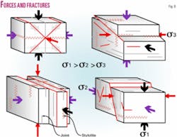
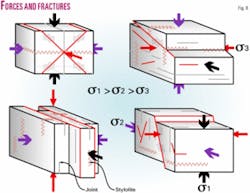
The first includes three active forces: sigma 1, 2, and 3, directed along x, y, or z axes and pointing to the intersection point of the three axes. When each of these forces is not opposed by an equal force, deformation (translation, folding, and strain) occurs.
The force sigma 1 is always the maximum force, sigma 2 the intermediate force, and sigma 3 the minimum force. The result of these three acting forces is strain, which might be represented by a second 3D ellipsoid. It shows the most likely shape changes (volumetric or distortional), including faults, folds, and fractures associated with the stress ellipsoid.
Strain is a function of the mechanical properties of rocks: Elastic, viscous, or plastic, respectively, signifying: No permanent deformation, permanent deformation, and stress-determined permanent deformation. These two ellipsoids more often than not do not have the same x, y, and z axes.
Fractures
Both 3D stress and strain ellipsoids define specific natural zones of mechanical failure, rock fractures, and faults in rocks subjected to stress (Figs. 8 and 9).
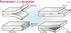
These zones are many: Fractures (Andersonian descriptive modes 1, 2, 3, and antimode 1, Fig. 10), joints, (master, cross, strike parallel, cross-strike, contained, pinnate, and tail), faults, fault zones, deformation bands, compaction bands, stylolites (pressure enhanced cone-in-cone dissolution), slickolites (surfaces of shear displacement, shortening, and dissolution), induced fractures, and fractures formed by massive reduction of overburden pressure, possibly changing sigma 1 vertical to sigma 1 horizontal, resulting in expansion of the rock volume and the opening of fractures.
The pressure enhanced cone-in-cone dissolution of rock may remove great percentages of the original thickness of rock units.
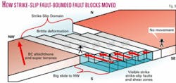
In the sedimentary section, brittle deformation occurred. Movement was mainly along reverse/thrust faults in the W, vertical strike-slip faults in the E, including those penetrating upward from within the basement and others, vertical and striking parallel to the basement ones, and confined to the sedimentary section, normal faults, squeeze faults, horizontal shear faults, and associated flower folds (see seismic transects ST 1-15 in Part 3).
There are also extension fractures (movement perpendicular to fracture surface), and shear fractures (movement parallel to fracture surface). Fractures and faults form when stresses exceed rock fracture strength and displacements range from macroscopic to microscopic. Historically, it was thought that fracture strength depended on lithology and overburden pressure.
To date, it is known that the overburden pressure is only one component of many that form fractures, such as pore pressure, stress dissolutions, chemical changes, rock mineralogy, and grain size, to name a few.
When available cores are not studied and the position of stylolites in the cores is not determined, one will be hard pressed to know what the actual orientations of stress ellipsoids and their three sigma stresses were. This means it is impossible to form an opinion on the 3D position of the strain ellipsoid and its three fracture directions. Ergo, one cannot predict the locations of fractures or where to drill a structure to intersect open fractures.
Thrusts
In the structured belt, thrusts were created in reverse-faulting/thrust stress regimes (sigma 1 horizontal) with the allochthon in the W acting as the main engine.
Rollovers/leading edges of thrusts are the main drilling targets. Their curvatures are important to assess fracture presence and enhancement of potential reservoir rock. Their relative age should also be assessed to determine availability of open fractures.
Strike-slip faults, parallel with structure trends and at angles to them, add fractures and enhance reservoir quality. In drilling a leading edge rollover, one might wish to assess the strike-slip component of that structure and drill into it to achieve maximum reservoir enhancement.
To date, many geologists and geophysicists commonly accept that multiple thrust structures are formed by one thrust having been overridden by a younger one, which in turn is overridden by another even younger thrust. This is the multiplex thrust structure. In it, the oldest thrust is the deepest and the youngest thrust is the shallowest structure.
Detailed structural analyses for this article demonstrate the reverse to be true. Most deep thrusts are younger than the overlying shallower ones. Furthermore, the more easterly the occurrence of the thrust the younger it is. It all comes down to rock plough effects: massive rock blades that ploughed easterly and moved immense volumes of rock.
Seismic transects ST 1-15 (Part 3 of this article) and Fig. 11 define the rock ploughs’ origin through time until all thrusting ceased.
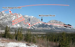
The McConnell Thrust is a good example of a massive rock plough (see photo, p. 40). This thrust (500+ miles long) is a gigantic composite thrust. On it, an entire WCSB sedimentary section moved from W to E on top of a similar section farther E. Due to erosion, it is not known how far this thrust moved E.
Compression and overburden pressure competed to be the larger force. The overridden section was pushed E, and under the enormous compression and overburden pressures broke in many parallel gas-bearing thrusts. Only the easternmost thrusts have rollovers at the leading edges. The thrusts beneath the McConnell Thrust are youngest in the E.
Folds
In addition to fractures and faults, folds are abundant throughout the structured belt (ST 1-15).
There are folds associated with thrust fault displacement and with sigma 1 force directed parallel to bedding, resulting in detachment, fault-propagation, harmonic, and gravity sliding disharmonic folds. There are also symmetric and asymmetric, recumbent, inclined, upright, cylindrical, noncylindrical, and isoclinal folds.
Many folds are riddled with all types of fractures. Predicting the occurrences of such fractures in deep-seated folds is the most difficult part of structural geology. This is as difficult as predicting the shape of the structures and pinpointing their locations at depth.
Successfully exploring the structures is more often than not a game of chance, despite chance of success analyses. Many deep folds with over 30° dipping front and back limbs are impossible to seismically image. Energy bounces off these dips and creates ghost impedance responses. Frequently, dipmeter readings are not supported by seismic data-folds simply do not show up.
Detached rock bodies
The structured belt contains similar structures in its Alberta and British Columbia portions.
In the first, thick carbonate sections overlain by clastics were deformed into huge thrusts, extending hundreds of miles along strike. In the British Columbia portion an alternating sequence of carbonates and shale gave rise to numerous smaller shingled thrusts separated by detachment zones.
There are six regional extensive “horizontal detachment zones,” mainly in shale sequences, >½-mile to 1 mile vertically apart. Two such surfaces enclose a rock body-the detached body. In total, there are five such rock bodies: The Cambro-Ordovician, Silurian/Devonian, Mississippian, Permian, and Triassic rock bodies (ST 12 and 13, Part 3) each >½ to 1 mile thick. A complex structured post-Triassic section (>2 miles thick) is present).
The detachment zones correspond with regional unconformities, marking periods of major structural upheaval. Structures are complex, and complexity was increased by regional shear manifested as strike-slip faults, shear zones, and flower folds.
Historically, the many thrusts were thought to be overthrusts that caused the W-E shortening of the sedimentary section. Compression from the W formed the thrusts. In this article, it is demonstrated that regional N to NW shear (including intense and widespread strike-slip faulting) had an enormous impact on the formation of structure and accumulation of hydrocarbons. This shear (Type I) was caused by a collision between a large landmass and the North American continent. It deformed, intensely in places, basement and overlying sedimentary section. In fact, shear and compression acted simultaneously, and numerous complex structures were formed.
Within the sedimentary section, subhorizontal shear (Type II) occurred between the basement and all above described detached rock bodies. The basement moved farther N-NW than the Cambro-Ordovician detached body, which moved farther N-NW than the Silurian/Devonian detached body, which in turn moved farther N-NW than the Mississippian detached body, and so on. It is not difficult to imagine the incredibly complex structures that formed by simultaneous multiple structural overprinting.
In addition to subhorizontal shear, the structured belt was subjected to NE-SW and W-E directed shear (Type III) in subvertical zones and strike-slip faults. This happened during their easterly movement. Internally the thrust bodies and detachment bodies were subjected to shear in the direction of their movement.
It is likely these shear zones and strike-slip fault zones enhanced reservoir quality in zones perpendicular to the strike of the structured belt. More important, these shear zones were the conduits for gas generated at great depths in the structured belt. This gas filled shallower structures.
The first detachment zone is the top of the regional basement. It is the gliding surface for the overlying shale section. In places, the basement supports large early (Cambrian-Ordovician) carbonate buildups up to 1 mile thick. One is exposed in the NE British Columbian portion of the structured belt. Others are suggested by seismic and structural evidence. These are deep drilling HPHT exploration targets. Possibly 5+ such buildups exist.
The second detachment zone is in the regional basal Cambrian-Ordovician section in a thick shale section. It deformed into a series of parallel NW-trending anticlines (shear boudinage) flat at the bottom and anticlinal at the top (ST 12 and 13). These folds have vertical axial planes, indicating vertical shear played a major role in their formation.
Hinge lines (fold axes) extend over hundreds of miles, undulate, and have individual apexes some 3-5 miles apart. Sometimes one fold splits into two en-echelon folds due to strike-slip shear parallel to the compressional fold axes. Going E, anticlines progressively lose amplitude and gradually go over into the layer cake of the Plains Domain.
This is the area where flanks of the shale cored anticlines exhibit steeply dipping zones. These penetrate the overlying section, cut through the shallower detachment zones, and create structure reversals (anticline to syncline and vice versa) in ascending order.
Resting on the shale anticlines are Upper Devonian carbonates. Numerous four-way closed rollover structures in these carbonates remain undrilled at depths greater than 3.5 miles. It is estimated that some 300 major rollover Devonian Wabamun targets remain undrilled.
The third detachment zone is between Devonian and Mississippian carbonates. It is difficult to recognize as it coincides with a major unconformity surface. In some cases, though, numerous E thrusts support four-way closed Mississippian rollovers.
Mississippian structures vary greatly from large elongated four-way closed rollovers to small thrusted homoclines along the strike of the structured belt. It is estimated that some 400 undrilled Mississippian structures locate between detachment zones two and three.
The fourth detachment zone is between Mississippian and Permian carbonates. It coincides with a seismically mappable regional stratigraphic and structural unconformity. Extensive changes in structural attitude mark this detachment. There are numerous undrilled small structures just below this detachment. Above it, many structures contain Permian reservoirs. All are regionally bound upward by the fourth detachment (between Permian and Triassic strata).
“Permian structures” are numerous and vary in amplitude, size; four-way closed rollovers, thrust faults, and strike-slip shear modified structures. Historically the Permian carbonate play was small, but recently Talisman Energy has proven a new and exciting gas play at Sukunka/Monkman that might increase in significance as drilling progresses. It is estimated there are some 200 undrilled Permian targets in the structured belt.
The fifth detachment zone is between Permian and Triassic strata. Triassic carbonates above this zone are found in large disharmonic folds with steep to vertical E-facing forelimbs (hanging walls) and gently W-dipping backlimbs (footwalls). Sometimes the folds change to thrust faults with heavily fractured carbonates in rollovers. Reservoir communication over distances greater than 3 miles is common in the hingeline portions of the anticlines. There are an estimated 300 Triassic structures to be drilled.
The sixth detachment zone is between Triassic and post-Triassic strata. The post-Triassic section overlying this detachment probably contains the most exciting exploration play of the structured belt. It is a resource play of unprecedented size.
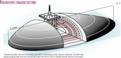
The entire post-Triassic section contains abundant coal seams, carbonaceous shale-siltstone-sandstone. It also contains many thousands of NW and N-trending double plunging anticlines. Multiple directional/slanted holes could be drilled from single drilling leases to target this section at varying depths.
It is estimated 5,000+ anticlines might be drill-targeted with multiple wells per drilling lease. Completion, including advanced fracturing techniques, holds the key to success. This section contains numerous different and complex combinations of compression, gravity sliding, and shear folds and faults. In places, this detachment zone marks structural reversal: Synclines below the zone change into anticlines above it.
Each of the estimated 5,000+ double-plunging hingeline anticlines contains 300-500 ft of cumulative coal beds and 1,000-1,500 ft of carbonaceous shale, sandstone, and siltstone. The coal beds alone have gross storage of 100-300 cu ft of natural gas/ton. Each structure measures about 2 miles long with 1,000-2,000 ft of stacked closures. Each structure might contain 100-300 bcf of original gas in place. This does not include gas stored in the other rock types. Each anticline might support multiple holes from one drilling lease (Fig. 12).
Total contained gas in these structures might be between 500 tcf and 1,500 tcf, a worthwhile resource play.
In general, the rock bodies between the six detachment zones contain numerous disharmonic folds, stacked thrusts with rollovers associated with compression/gravity sliding, in the western reaches of this belt. Going E, there are gentle anticlines and broad synclines and compression and shear-formed low-angle W-dipping thrusts in the W flanks of these anticlines that contain small moderately E-dipping backthrusts. In more competent sections, the shale cored anticlines are broken through and small thrusts are in evidence.
All six detachment zones are not present everywhere in the structured belt. In its northernmost British Columbia portion, the first and deepest detachment zone is present. Gravity sliding prevented the development of the other five zones. In its N Alberta portion, two zones are present. In southern Alberta, in the Coleman-Waterton-Pincher Creek region, only the deepest detachment zone is present. The other five did not develop due to massive E ploughing of the McConnell rock blade.
Origin of the oil sands belt
The collision between foreign landmass and Canadian Shield caused massive deformation in basement and overlying sedimentary section.
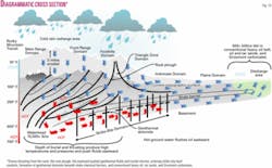
It produced a high topographic relief that attracted abundant meteoric water recharge and regional groundwater flows (down to 7 miles) with heads of 10,000+ psi. Water flowed 400 miles E to regional discharge regions close to the shield outcrop (Fig. 13).
The high pressure groundwater flow occurred simultaneously with E thrusting. The latter included high rock and pore fluid temperatures and pressures, mineral alterations, and crystal slurries. The combination flow and thrusting squeezed and laterally pushed heated and pressurized solution fluids/crystal slurries E ahead of the thrust front and into and through porous rock formations in the Strike-Slip and Plains domains.
When vertical conduits (strike-slip faults) were reached, the fluids vented upward and entered sheared and-or porous strata. In limestone, partial conversion to geothermal dolomite occurred, resulting in geothermal porosity and permeability enhancement of the rock. Further enhancement occurred where the carbonate section is overlain by shale (chemical barrier).
Thus, many dolomite reservoirs for oil and gas were formed capped by shale. The Slave Point represents this setting in NE BC. Others are the Triassic Pardonet/Baldonnel, the Permian Belloy/Belcourt, and the Debolt/Mount Head formations.
In sheared and-or porous sandstones, these solutions produced calcite cement, quartz overgrowth, silica cement, and possibly clay plugging, whereas in sheared shale silicification and calcification might have resulted. Invariably, bitumen is present in rocks affected by the intrusion of solution fluids/crystal slurries.
Water recharge heads and thrusting pushed the heated solution fluids/crystal slurries even farther E into formations not affected by deformation. The resultant flushing occurred along a broad front, 1,000 miles long and 400 miles wide, parallel to the mountains. Formation fluids, including water, oil, and gas, where pushed E thus creating regional fairways for hydrocarbon migration.
Higher temperatures allowed for more solution gas in oils, but gas was expelled from the oils on their way E while cooling off. There fluids including oil entered the younger, less compacted, porous rock sections over wide areas that presently contain 1) the conventional heavy oil belt, extending from N of Lloydminster to the US border, 2) the bitumen/tar sands extending from Fort McMurray to Peace River, and the 3) Grosmont carbonate bitumen belt farther N.
Most gas escaped, and oxygen-rich formation and meteoric waters oxidized the lighter ends, and heavier hydrocarbons remained. The enigmatic Turner Valley field structure (seismic transect ST 3, Part 3 of this article) is the only structure that both captured and retained large volumes of oil (1.3 billion bbl) in a Mississippian carbonate reservoir, possibly sourced from Cretaceous source rock from beneath the Turner Valley thrust.
Geochemistry evaluations of source rock, hydrocarbons, and coal maturation should be treated with great caution and in an unconventional manner because of this major hot fluid flushing of the sedimentary section and the eroded section in the WCSB.
Under normal overburden conditions, source rocks deliver certain volumes of hydrocarbons. The same source rock will deliver substantially more hydrocarbons when it is subjected to squeezing and torque (wrung out) from compression and simultaneous regional shearing.
Next week: The exploration/structural domains are distinctly different in structural style as illustrated in 15 seismic transects.
