WCSB STRUCTURAL DOMAINS-1: W. Canada structured belt given high gas potential
It is projected that 100+ tcf of natural gas awaits discovery in the structured belt of the Western Canada Sedimentary basin (WCSB).
There are 2,000+ undrilled, multitarget structures with known and new play types, including fractured rock bodies and high pressure-high temperature deep carbonate buildups.
Estimated numbers of undrilled structures in the structured belt are: 50+ Precambrian, 5+ large Cambrian-Ordovician carbonate buildups, 300+ Devonian, 400+ Mississippian, 200+ Permian, 300+ Triassic, and 5,000+ post-Triassic.
The 5,000+ shallow to medium depth structures contain resource plays in sequences of coal, sandstone, siltstone, and shale alternating and interbedded with carbonaceous sandstone-siltstone-shale 6,000+ ft thick.
Future exploration will only be successful when stress and strain are understood and when structural geology is given its appropriate place in exploration teams. Seismic interpreters create geometry form maps from impedance similarity recognition and mapping. They should not take the place of structural geologists as unfortunately so often occurs. The latter should interpret the geometry form maps and prepare evolution of forces and strains.
Drilling has discovered 41 tcf of marketable gas, including 8+ tcf in strike-slip structures and 33 tcf in thrusts and gravity slide structures, in the structured belt.
Described in this four-part article is a redefinition of force fields that formed the WCSB structured belt. Subduction zones did not cause the belt. If one ever existed it was overridden by a large foreign rock body that slammed into and overrode the Western Canadian Shield. In the process it ploughed E the sedimentary section of the WCSB.
A series of massive composite thrusts developed. The oldest ones are in the W and the youngest in the E. Each of these acted as a rock plough, pushing the sedimentary section ever eastward.
This assessment is based on regional seismic transects, surface geology, and well data. Six exploration/structural domains are recognized. Structures were formed by simultaneously acting major compression/thrusting, gravity sliding, and transpression/shear force fields.
The structured belt of the WCSB probably is one of the most complex “structures” in the world, probably too taxing for most that explore it for hydrocarbons. It is a structural enigma, not just another thrust belt.
This redefinition of forces changes exploration target definitions and enables recognition of potentially huge new resource plays.
Introduction
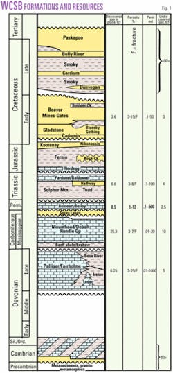
For more than a billion years, the western Canadian portion of the North American continent was a receptacle of sediments (Fig. 1). The WCSB is one of the world’s most prolific hydrocarbon basins.
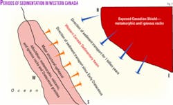
Sediments mainly were sourced from the east (Fig. 2) by erosion of igneous-metamorphic basement rocks of the Canadian Shield. Sediments include Precambrian to Cambrian mainly siliciclastics (>3 miles thick) overlain by Cambro-Ordovician to Mississippian-Permian carbonates and shale (2 miles thick) and Triassic siliciclastics and carbonates (0.5 mile).
A second sediment source area emerged with massive structural upheaval in the W in post-Triassic time. A large foreign body slammed into and overrode the western Canadian Shield. From then onward, the WCSB received sediments from E, S, and W. Post-Triassic strata (3 miles thick) include thick sections of Cretaceous siliciclastics with abundant Barnett-like shale-siltstone and coal seams, representing an untapped major gas resource play.
The WCSB sedimentary section contains many basinwide unconformities, reflecting periods of worldwide tectonic upheaval. Its western reaches were deformed into a structured belt by the Nevadan, Sevier, and Laramide orogenies.
In British Columbia, the Rocky Mountain Trench stretches from the US border to the Yukon. It separates a region formed primarily of plutonic, volcanic, and metamorphic rocks (allochthon) intruded by numerous Cretaceous granites in the W from the Laramide Rocky Mountains and Foothills comprised of folded and faulted sedimentary rocks (structured belt of the WCSB) in the E.
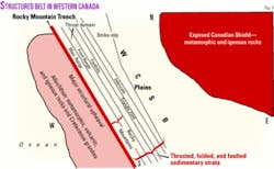
The structured belt (Fig. 3) encompasses the Rocky Mountains, Foothills, and the western structured portion of the Plains of western Alberta and Northeast British Colombia. It covers more than 100,000 sq miles and extends more than 1,000 miles in a northwesterly direction with a width of 100 miles from the Alberta/Montana border in the S to the line between British Columbia and the Yukon Territory in the N.
This region is bordered in the E by the “undisturbed” Plains sedimentary section (Precambrian to Tertiary) that extends E to igneous and metamorphic outcrops of the Canadian Shield. To the W, it is bordered by the Rocky Mountain Trench.
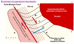
Commonly, it is mistakenly assumed that subduction created the structured belt of the WCSB. Instead, it was a N-moving elongated land mass (allochthon, Fig. 4) an estimated 300 miles wide, 2,000 miles long, and 20-30 miles thick that collided with and slid onto the W portion of the massive Canadian Shield, core of the North American continent. It includes most of British Columbia and moved parallel to its NW-SE long axis, guided by ancient subsurface oceanic crustal features.
Any structured belt associated with subduction and passive continental margin was overridden by this N-moving continental rock body. It scraped over the shield like a massive rock plough. It ploughed E the sedimentary section of the WCSB.
A series of massive composite thrusts developed. The oldest ones are in the W and the youngest in the E. Each of these acted as a rock plough pushing the sedimentary section ever farther E. This assessment is based on regional seismic transects, surface geology, and well data.
Six exploration/structural domains are recognized. Structures were formed by simultaneously acting major compression/thrusting, gravity sliding, and transpression/shear force fields. The shield, composed of rigid igneous and metamorphic rock, resisted deformation.
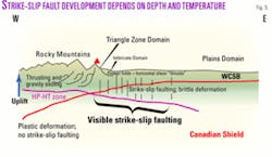
At a depth of >5 miles (overburden pressure >30,000 lb/sq in.), it deformed plastically (Fig. 5). At shallower depths, deformation was brittle and the shield eventually broke in numerous parallel, generally vertical, mainly N-S and NW-SE, and minor NE-SW and E-W striking strike-slip fault blocks.
Predominant right-hand lateral movements along these faults sheared the basement many kilometers to the N and shortened it E-W. The pliable sedimentary cover, resting on this basement, sheared sideways to the NW in places along up to six subhorizontal layers separated by detachment zones.
While being deformed by shear, it simultaneously was horizontally shortened up to 100 miles by E-directed compression (thrusting and gravity sliding) in the form of enormous rock ploughs. NE and W-E shear and strike-slip zones developed within the rocks pushed by the rock ploughs.
In this dynamic setting, the section structurally thickened vertically, over large areas. While all this deformation was proceeding, sediments continued to accumulate in the WCSB, but now derived from two provenances: one in the E and a second, new one, in the W (Fig. 2).
The moving landmass formed very high topographic elevations in the W. It compound thrusted the sedimentary section to great heights, and it pushed the younger, less-compacted sections even higher. This facilitated eventual gravity sliding to the E.
The sedimentary section horizontally shortened (100 miles). Many thrusts in the eastern Canadian Rocky Mountains are compressional (uphill thrusts in the classical sense) in origin. Equally, many of them, especially the younger ones farther E, are gravity gliding structures. Locally, heavily imbricated and much shortened Cretaceous sections support this assertion (see seismic transect ST 6 in Part 3 of this article).
Immense continental forces are needed to push regional rock bodies uphill. Only a fraction of such force is needed to push the bodies downhill, and gravity will maintain the momentum of movement, even when the body is breaking up in numerous parallel substructures such as thrusts and imbricates.
The structured belt
The structured belt of the WCSB includes six exploration/structural domains.
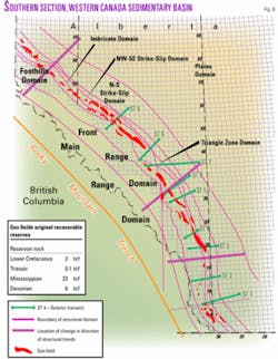
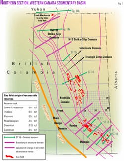
Five domains trend parallel NW. Figs. 6 and 7 are maps of the Alberta and British Columbia portions of the structured belt, respectively. From W to E, these are the Thrust Belt, Triangle Zone, Imbricate, Strike-Slip, and Plains domains. The Gravity Slide Fold Belt domain is the sixth domain.
In these domains, most structures were formed by the simultaneous interaction of several major force fields associated with compression, gravity sliding, and shear. The body of published work, although large, fails to recognize the simultaneity of compression and shear.
Some notable papers are by Gallup,1 Bally et al.,2 Dahlstrom,3 Jones,4 Price,5 Cooper,6 Suppe,7 Moore,8 McMechan and Thompson,9 Groshong and Epard,10 Wright, McMechan, and Potter,11 and Mundy.12 Noteworthy industry contributions were made by Jamieson,13 Newson,14 Goetz,15 Dobson,16-17 and Green and Granier.18
Pre-1900 American settlers described the region to include the “Plains” (prairie), “Foothills” (hills at the foot of the mountains), and “Rocky Mountains.” These terms erroneously attained “structural geological” meanings.
Original topography of the structured belt was at least 3 miles higher than the current one. Sigma 1 and overburden pressures were much higher then than today. This is suggested by anomalously high seismic velocities (>16,500 fps) of shale sections as compared to the velocity (11,000 fps) of the same shale sections in the undisturbed Plains to the E.
The sedimentary section is in a state of “overcompaction.” It has not had sufficient time to structurally relax and decompact in places, giving rise to local overpressure zones. These anomalously high seismic velocities and complex structures make seismic processing and interpretation most difficult tasks.
The regional topography once included towering mountains, which were almost leveled by four major periods of glaciations, in the past 2 million years.
The structural trend of the structured belt from S to N changes several times from NW to N and even from N to NE. These changes take place at hinge lines of unknown origin (Figs. 6 and 7).
Oil and gas
To date, only the E portion of the vast structured belt is explored.
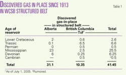
A rewarding 41 tcf of gas in place and 1.3 billion bbl of oil in place were discovered in 169+ fields and pools since 1913 (Table 1). These discoveries followed an oil find in 1859 at Stoney Creek, NB, and gas finds at Medicine Hat, southeastern Alta., in the 1890s.
Many discovered fields include more than one structure: Sukunka field includes the discoveries of seven gas accumulations in series of shingled, independent, parallel anticlines.
Industry discovered four fields in 1910-51 (1/10 years), 47 fields in 1951-63 (4/year), went without a discovery in 1963-67, found 52 fields in 1967-81 (3.5/year), two fields in 1981-89 (1/4 years), and 20 fields in 1980-2007 (1.2/year).
Fields were discovered by Shell (12), Gulf (5), Imperial Oil (5), Phillips Petroleum (4), Suncor (4), Hudson’s Bay (4), Pacific Petroleum (3), Oakwood Petroleum (3), Sun Oil (2), Sinclair (2), Czar Resources (2), BP Canada (2), Dome Petroleum (2), Devon Energy (2), and Talisman (3). More than 40 other companies discovered one pool each.
Recently, gas discoveries (each rumored >0.5 tcf in place) were made in Permian carbonate reservoirs overlain by shale in asymmetric folds (Monkman by Talisman), in a fractured Leduc reservoir with more than 400 ft of net pay (Tay River by Shell Canada), and in Cambrian/older strata (Talisman). Clearly, this demonstrates the “Foothills” is a viable, exciting, and rewarding exploration region!
The common play is structural with stratigraphic components such as fractured carbonate, reefs, platform margins, and pinnacles. As a rule, reservoir quality is enhanced by geothermal dolomitization,19 fracturing, and microshear faulting (Table 1).
Many discoveries will be made in the future if the oil and gas industry takes on increased risk scenarios, moves farther into the mountains, drills deeper targets, and pursues shallow resource plays.
Seismic acquisition/processing and structural geological modeling hold the key to success for the deeper targets. Completion engineering is the key for the shallower resource plays.
Drilling depths will eventually approach 7.5 km (25,000 ft), possibly deeper, at which depths high pressure-high temperature conditions (pressures >15,000 psi and temperatures >300° F.) prevail. To date, drilling depths have not exceeded 20,000 ft. The plays become costlier with deeper drilling, 3D, and 3C-3D seismic acquisition, and construction of roads, leases, tie-ins, and pipelines.
Difficulty of access and increasing distances to infrastructure add to the costs. Development of less costly shallower resource plays may be favored over expensive deep target drilling in the near future.
Despite the 2005 increase in natural gas price, drilling in the “Foothills” has not picked up as it has in other regions of the WCSB. Risk adversity, long lead times, quarterly reporting to financial markets, and dry hole and F&D costs affecting the financial “bottom line” are viewed as possible causes. Others might include inadequacy of 3D seismic acquisition and processing to properly define deeper structures. Recent downturns in gas prices will probably slow exploration in the region.
Exploration challenges
The structured belt does not easily give up its treasures.
Especially troublesome are seismic data acquisition, processing, and interpretation. Surface mapping of anticlines no longer defines drilling locations and discoveries like it did for giant Turner Valley field (1913, 1.3 billion bbl in place).
Since 1950, increasingly complex acquisition and processing methods allowed clearer and more focused images of structures in the belt. Historically, company managements rely on seismic interpretations to guide their exploration efforts. It had worked well in the undisturbed portion of the WCSB. There, seismic and geological modeling are closely linked.
Recognizing and mapping porosity are important. So, why would it not work similarly in the structured belt? And, indeed it did work well. Numerous discoveries were made guided by seismic acquisition and interpretation. Oil industry management accepted a model of simplicity: “Compression from the W resulted in thrusting to the E.” The reality is a tad more complex.
Currently, most shallow exploration targets (<10,000 ft), excluding resource plays, are drilled in the belt. The trend is to drill deeper targets. Unfortunately, seismic energy decreases with depth and reduces the definition of such targets. Consequently, acquisition of deep data, processing, and imaging and interpretation thereof are a challenge.
Commonly, structural geologists are not included in this process until the last minute. No wonder the end results often represent wide gaps between the real structures and those based on interpretations of iterated isotropic abstract mathematical treatises of raw seismic data.
Cases in point, deep structures with limbs that dip more than 20° are difficult or impossible to image. Thus, seismic interpretations become unrealistic to bizarre. In most cases, interpreters through recognition and mapping of impedance surfaces create geometric form (structure) maps, also called “wet blanket” maps. These maps show structural highs connected by contouring that ignores overthrusted portions of the structures.
A further problem is posed by the many active “structural” seismologists, who worked in a structured belt but had no formal structural geological training. Thus, they lack understanding of how structures are formed and what is plausible and what is not in their interpretations. Besides, not being aware of certain structural forms probably precludes mapping thereof.
Once a deep structure is identified, a structural geologist should complete mechanical and kinematic analyses of that structure. This is to determine the forces (stress) that formed the structures’ geometry and the history of their development. It also aims to understand the genesis of strain (fractures) in the region.
Combined, it leads to an understanding of 3D stress and strain through time. Investigations normally should include studies of surface structures, subsurface data, including cores, well cuttings, and logs, and the review of analog structures. Unfortunately, such analyses are seldom performed as an essential part of team work leading up to budget requests and eventual drilling.
It is said, it all comes down to luck, geosteering, FMI logs (bedding and fracture dip readings) and integration with seismic data. Dipmeter interpretations work well in structured regions where deformation is not too complex and uniform. This is not the case in the subject structured belt, where structural complexity reigns: simultaneous thrusting and strike-slip faulting.
FMI logs show the presence of fractures (open, closed, and healed) with microresistivity measurements. Openings vary from a half-inch to 1 micron (about 1/2,500 in.). In laboratories, it is demonstrated that micron fractures might add 2% to 10% porosity (gas storage) to a deformed rock body. A 1/25 in. open fracture is represented by a 4-in. wide dark band on a 1:1 scale FMI log. This is a ratio of 1 to 100. This means that a 1 micron fracture should be represented by 100 x 1/25,000 in. = 1/250 in. dark band on a 1:1 scale FMI log, beyond the image resolution of that log. How wide should an open fracture be before it is visible on an FMI log?
Most evaluation engineers admit the contribution of fractures to both reservoir storage and producibility is not fully understood, especially not in not-so-obvious structural settings.
Another difficult problem faced by seismologists is that unless the rock body is entirely homogeneous from a seismic velocity point of view, it is practically impossible to mathematically precisely position a vertical well or a directional well in either 2D or 3D seismic surveys. Well synthetics might be positioned and stretched to fit the processed data, but it will always remain an inexact solution to an unsolvable problem.
Next week: How structures were formed in the structured belt, including fractures, thrusts, folds, detachment zones, and detached rock bodies, and the origin of the conventional heavy oil/oil sands belt.
The author
Henri Wennekers ([email protected]) has structural geological experience that dates from 1956 in the Alps, Pyrenees, Cantabrian Mountains, Apennines, and Bergamasque Alps in southern Europe. From 1968 onwards, with Sproule Associates Ltd. and PetroCanada, he gained further experience in the numerous northern Canadian and Greenland fold belts. He initiated, with a large team of geologists and engineers in 1976, the first regional resource analysis of 25,000 wells on 9 million acres around Lloydminster, identifying a 28 billion bbl resource base. He coordinated regional studies of Libyan basins for Sirte Oil Co. in 1988-96 and structurally mapped areas of Libya, Algeria, Chad, and Sudan. He has been a wellsite geologist and consultant since 1997. Wennekers initiated, organized, and led 19 geological field expeditions to structured regions in the past 45 years. He has a BSc, MSc, and a DrSc from State University of Leiden, Netherlands.
