How the petroleum system relates to the petroleum province
Petroleum System - 2
A petroleum province and a petroleum system (PS) have very close links. The province represents in 3 or 4 dimensions the envelope of the unique or multiple PSs it contains. It is also the map representation (in 2 dimensions) of the PS.
The province is characterized in terms of richness (the quantity of oil and gas discovered, if possible calculated by surface unit) and in term of habitat, the representation of the accumulations sorted by size. The PS, which represents from a certain point of view the dynamic and morphological aspects of the province, is defined by the names of its source rock and the main sealed reservoirs.
Richness and efficiency of a PS are determined by the same geological elements: initial potential and expulsion efficiency of source rocks, potential of retention of seals and barriers, reservoir qualities, and proximity between reservoir/carrier beds and source rocks.
This last point leaves open the discussion on the spatial relationship between the SR and the reservoir/seal pair.24 This relationship (or elevation and distance) can be ranked, in terms of migration efficiency, into four main classes as follows:
1. Imbricated: the reservoir and mature source rock are intercalated; this is the best case for migration efficiency. One of the best examples is provided by the Gabon Senonian basin, where turbiditic channels and lobes dated Cenomanian to Campanian (Cap Lopez-Azile to Pointe Clairette) are interbedded with shaly high marine OM content intervals. Locally in this basin, PSY of 60% is calculated for some fields.
A global PSY of 31% is estimated for these excellent "imbricated" cases.
2. Superposed: The source rock lies directly below or above the reservoir, meaning that the migration occurs "per ascensum" or "per descensum." This is the case for the Libya Murzuk basin, where Silurian Graptolite hot shales cover or onlap laterally the Ordovician Hawaz-Memunyat reservoirs. Another example is the Austral basin, Argentina, where the Inoceramus Inferior formation is the source rock directly overlapping the Springhill reservoirs.
3. Juxtaposed: A fault allows contact between the source rock and the reservoir. This the case in many areas of the North Sea, where Kimmeridgian hot shales are laterally in contact with the Triassic or Mid Jurassic reservoirs.
4. Separated: An impermeable section isolates vertically or laterally the mature source rock from the reservoir. In this situation, faults and fracturation can help migration. This is the case for the Lower Congo basin (Iabe/Malembo PS).
Another key element is the preservation of the hydrocarbons in the trap.
Biodegradation, tertiary migration (alterations by tilting, post-trap deformations) can jeopardize many accumulations that will not be accounted for in the efficiency of the PS.
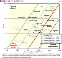
It is not surprising, therefore, that the richest provinces are those that correspond to the most efficient PSs all along the geopetroleum chain. The Maracaibo basin, associated with the PS sourced by the La Luna interval, and the Arabo-Iranian basin, with its multiple source rocks and evaporitic seals, are excellent examples. But the opposite is not necessarily true: Efficient systems can correspond to poor to fair provinces (see the diagram richness vs. PSY, Fig. 4).
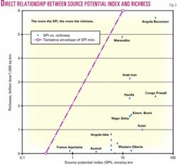
In fact, a better and more intuitive correspondence is observed between the richness of a subbasin (accumulations of fields per surface) and the source potential index (SPI) of the PS (Fig. 3). Demaison4 also mentioned this point.
In some basin morphologies, the richness but not the efficiency of the PS is ensured by a continuous subsidence, under the effect of the basin deformations and the continuity often up to present day of the generation and expulsion of hydrocarbons from source rocks.
This is particularly the case for large deltaic basins and foredeep basins where the subsiding trough moves position through the basin evolution. In the deltaic system of the Niger Delta, for example, a fair richness of 1.6 million boe/sq km corresponds to a modest efficiency of 1.4%.
In the large foreland basins like the Western Canada or the Venezuela Orinoco basin, the source rock richness is altered by the weakness or lack of seals and closures and by long-distance, insufficiently focused migrations. In fact, it is no coincidence that these two basins are bordered by huge extra-heavy oil and bitumen or bituminous sand accumulations. They are trapped against the basement edge, and this trapping can be assisted by a centripetal hydrodynamism.
Other counter examples are observed in the North Sea. The Kimmeridge-Brent PS, described by Klemme,25 and the Upper Jurassic-Ekofisk PS, described by Comford,26 look more rich than efficient. This is explained by limited seal retention and entrapment and the existence of hydrocarbon leakage or dysmigrations as exhibited by direct hydrocarbon indicators (DHI), gas chimneys on 2D seismic lines or 3D seismic cubes.
On the contrary, Magoon and Valin24 observed that efficiency depends heavily on the possibility of direct communication and short distance between the source rock and the reservoir/seal pair, as previously stated.
Particularly to be emphasized is the presence of dominant small-scale vertical migration and highly imbricated systems. The small Heath-Tyler PS in Montana has a PSY of 36% and is the most convincing (and perhaps unique) example.24
Fair to excellent PSY is observed in highly structured passive margins like the Gulf of Guinea, where structural highs and faults help efficient vertical migrations, for examples: the Gabon Senonian basin with a PSY of 32% enhanced by an imbricated system, and the Angola Iabe with a PSY of 4% corresponding to a separated system. More generally, this is illustrated by rich rifts, e.g., the Lower Congo basin (Congo presalt and Angola Bucomazi formation).
Moreover, almost 80% of hydrocarbon resources correspond to relatively concentrated PSs.27
The age and the duration of the kitchen generation also plays a major role. Recent periods are the most favorable. This is one of the reasons for the La Luna PS efficiency of 14% in the Maracaibo basin.
It was observed that PSs are located in the geological timetable around the limits of major geological cycles, around periods characterized by a certain tectonic or paleogeographic instability. It could be expected that these periods would present favorable conditions for hydrocarbon migration, for example along unconformities and reservoirs surfaces although not necessarily for the concentration of source rocks.27 This is the case for the Alaska southern flank of the Barrow arch, where Upper Jurassic source rock is incised and onlapped by transgressive Neocomian sandstones.
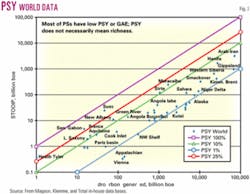
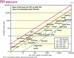
From a general point of view, the low PSY values are surprising (Fig. 2 and Table 1). They are often lower than 5%, frequently in the range of 1-2%, and sometimes less than that.
The rich provinces of the Arabo-Persian Gulf, Western Siberia, and the Saharan Triassic basin show values of 1-5%. This relative inefficiency mostly reflects the large number and variety of cases of losses and leakages that occurred during the existence of the PS.
In the Illinois basin, for example, a basin of Paleozoic shelf with calm tectonics but not very well protected, the source rock of the New Albany formation of Devonian to Mississipian age is estimated to have generated 78 billion boe.
Of this amount, only 11 billion boe, i.e., a PSY of 14%, has been recognized as STOOIP. Two thirds of the generated and expelled hydrocarbons have been lost during the 225 million years of the PS life, 9 billion boe were lost during migration, and 58 billion boe following erosions.28
Overview
The PS precisely formalizes the relationships between different sedimentary, geochemical, tectonic, thermal, and hydrogeological events distributed in space and time that contribute to the formation of a sequence of resulting hydrocarbon accumulations.
Describing the geodynamic evolution of the basin and its geological history, modeling has become an essential technique linked to the PS concept. This method brings a coherency and a sequence of logical steps for the understanding of geological phenomena. Other tools such as prospect calculation software programs, calibrated to references datasets, evaluate hydrocarbon charge and seal retention efficiency (capillarity or hydrofracturation).
Together modeling and prospect calculations allow the interpolation and extrapolation necessary to evaluate and rank remanent or frontier hydrocarbon potential (prospects and leads).
The PS has thus emerged after a couple of decades as a fundamental tool for petroleum exploration.
The PSY is kept as an effective way to compare PSs worldwide, but it needs to include a notion of scale: An object calibrated or not (prospect or field) in a basin will exhibit much higher ratio than the PSY that corresponds to the subbasin itself. For example, some fields of the Gabon coastal basin or of the Lower Congo basin have shown PSYs of 40-60%, although the PSYs of their respective subbasins are much less than that.
Technical progress, in particular the improvement of experimental analysis, modeling, i.e., the multicompositional approach or grid size refinements, bringing more and more details and precision but also complexity in the PS representation, must not hamper the exploration operation processes.
It seems necessary to keep a synthetic global vision of the PS in a given province, an empirical approach and naturalist reasoning guide lines.
To do it we must concentrate on concepts of mega PS, subpetroleum provinces, and finally the exploration unit, prospect or lead itself, at each step of the sequence of evaluation which constitutes the "geopetroleum chain." F
References
1.White, I.C., "The Geology of Natural Gas," Science, Vol. 5, June 26, 1885, pp. 43-44.
2.Perrodon, A., "Géodynamique pétrolière," Masson and Elf Aquitaine, 1980.
3.Dow, W.G., "Application of oil correlation and source rock data to exploration in the Williston basin," AAPG Bull., Vol. 58, No. 7, 1974, pp. 1,253-62.
4.Demaison, G., "The generative basin concept," AAPG Memoir 35, 1984, pp. 1-14.
5.Ulmishek, G., "Stratigraphic aspects of petroleum resource assessment," AAPG Studies in Geology 21, 1986, pp. 59-68.
6.Magoon, L.B., and Dow, W.G., "The Petroleum System," AAPG Memoir 60, 1994, pp. 3-23.
7.Mello, M.R., and Katz, B.J., "Petroleum Systems of South Atlantic Margins," AAPG Memoir 73, 2000.
8.US Geological Survey, "World Petroleum Assessment 2000, Description and Results," USGS Digital Data Series DDS-60, 2000.
9.Perrodon, A., "Petroleum systems: models and applications," Journal of Petroleum Geology, Vol. 18, No. 4, 1995, pp. 471-476.
10.Perrodon, A., and Masse, P., "Subsidence, sedimentation and petroleum systems," Journal of Petroleum Geology, Vol. 7, No. 1, 1984, pp. 5-26.
11.Talukdar, S.C., and Marcano, F., "Petroleum systems of the Maracaibo basin, Venezuela," AAPG Memoir 60, 1994, pp. 463-482.
12.Guardado, I.R., et al., "Petroleum System of the Campos basin, Brazil," AAPG Memoir 73, 2000, pp. 317-324.
13.Scheollkopf, N.B., and Patterson, B.A., "Petroleum systems of offshore Cabinda, Angola," AAPG Memoir 73, 2000, pp. 36-76.
14.Amaral, et al., AAPG Rio 2000.
15.Foucht, D., et al., "Green River Petroleum System, Uinta basin, Utah," AAPG Memoir 60, 1994, pp. 399-419.
16.Ekweozor, C.M., and Daukozou, E., "Northern Delta depobelt portion of the Akata-Agbada petroleum system, Niger Delta, Nigeria," AAPG Memoir 60, 1994, pp. 599-614.
17.Bordenave, M., and Burwood, R., "Source rock distribution and maturation in the Zagros orogenic belt," Organic Geochemistry, Vol. 16, No. 1, 1990, pp. 369-387.
18.Bordenave, M., "The Mid-Cretaceous to Early Miocene Petroleum System in the Zagros domain of Iran and its prospect evaluation," abs. AAPG annual meeting, Houston, 2002.
19.Magoon, L.B., et al., "Petroleum Systems of the Alaskan North Slope—a progress report," abs. AAPG Bull., Vol., No. 86, 2002, p. 1,151.
20.Bird, K.I., "Ellesmerian Petroleum System, North Slope, Alaska," AAPG Memoir 60, 1994, pp. 339-358.
21.Mac Gregor, D.S., "Giant fields, petroleum systems and exploration maturity of Algeria," Petroleum Geology of North Africa, Geol. Soc. of London Special Pub. 132, 1998, pp. 79-96.
22.Hollet, D., "Petroleum Geology of Libya," Elsevier, 2002.
23.Laherrère, J., Perrodon, A., and Demaison, G., "Undiscovered petroleum potential," Petroconsultants, 1994.
24.Magoon, L.B., and Vali, Z.C., "Overview of Petroleum System case studies," AAPG Memoir 60, 1994, pp. 329-338.
25.Klemme, H.D., "Petroleum Systems in the world that involve Upper Jurassic source rocks," AAPG Memoir 60, 1994, pp. 51-72.
26.Comford, C., "Mandal-Ekofisk Petroleum System in the Central Graben of North Sea," AAPG Memoir 60, pp. 537-572.
27.Shirley, K., "'Systems' study gave insight," AAPG Explorer, August 2002, pp. 22-31.
28.Lewan, M.D., et al., "Material balance assessment of New Albany-Chesterian petroleum system of the Illinois basin," AAPG Bull., Vol. 86, No. 5, 2002, pp. 745-777.
The authors
Jean-Jacques Biteau (jean-jacques.biteau@ total.com) is head of the geology department of the New Ventures Division in TotalGeosciences headquarters, Paris. He joined the company in 1979 and has held various exploration management positions with Elf since 1992, including the exploration of Block 17 in Angola from 1996 to 2000. He has large experience with African geology. His interests are petroleum systems synthesis and fast track interpretations. He is graduated geologist-engineer from Ecole Superieure de Geologie de Nancy.
Ghislain Choppin de Janvry is a senior geologist in Total's New Ventures Division in Paris. He has spent his entire career with Total since 1973. He has been applied geochemistry coordinator during several years in the same division and also worked overseas in various exploration and production teams in Abu Dhabi, Cameroon, Tunisia, and Indonesia. He is a geology graduate of Ecole Nationale Superieure des Petroles et des Moteurs.
Alain Perrodon served as advisor of exploration in the Elf group where he was also in charge of geological services. He was involved in the great Saharan exploration with the giant Hassi Messaoud oil and Hassi R'Mel gas discoveries. He was graduated from Ecole Superieure de Geologie de Nancy and Ecole du Petrole. He is now retired.


