Detachment folds and triangle zones: Unexplored hydrocarbon potential along eastern Cumberland escarpment, Tenn.
An 80 km-long unexplored subsurface detachment fold, the Eureka structure, exists in the southern Appalachian thrust belt just east of the Cumberland escarpment in eastern Tennessee.
The Eureka structure involves Ordovician and older rocks that are productive elsewhere in eastern Tennessee, Kentucky, Ohio, and Virginia, and here lie within the oil-gas window.
The eastern Cumberland Plateau escarpment rises 400 to 600 m at the western boundary of the Valley and Ridge in eastern Tennessee. Isolated oil and gas wells and industry seismic reflection lines provide subsurface geologic data and resolution of structural geometry beneath the escarpment.
Seismic lines reveal a deep 80 km-long detachment fold just east of the escarpment in the Chattanooga fault footwall. This major untested structure is located well inside the oil-gas window and contains known (Knox and Middle Ordovician) oil and gas-producing units.
Deformation in thickened units in the Eureka structure varies along strike from development of a triangle zone and splaying off the basal detachment to subseismic scale complex folding and faulting. Above the detachment fold, the Chattanooga, Harriman, Rockwood, and Cranmore Cove faults dismembered a single thrust sheet in a foreland-to-hinterland deformation sequence. The thrust sheet evolved with three major detachment levels: (1) Rome formation; (2) Silurian siltstones and shales; and (3) Upper Mississippian and Pennsylvanian rocks, the latter extending westward under the plateau as a blind thrust.
Between the blind thrust and overlying Rockwood and Cranmore Cove faults, Mississippian and Pennsylvanian rocks are substantially deformed in an exposed shallow detachment fold near Rockwood, Tenn., and Pennsylvanian rocks develop faults dipping toward both the foreland and hinterland. The shallow detachment fold is an exhumed analog for the deep detachment fold, which may be the largest unexplored structure in the Appalachian region.
Introduction
The collision of Africa with Laurentia stacked sheets of Early Cambrian to Pennsylvanian rocks along the eastern margin of North America during the Mississippian-Permian Alleghanian orogeny,1 2 3 forming the Appalachian foreland fold-thrust belt (FTB).
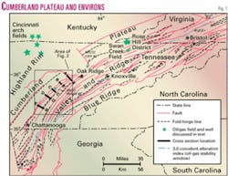
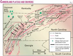
The eroded remains of the FTB today comprise the Appalachian Valley and Ridge and Cumberland/Alleghany plateau (Fig. 1). As much as 50% shortening across the FTB in East Tennessee (ETN) is concentrated along a few major thrust faults3 (Fig. 1).
Numerous structural studies2 4 5 6 7 and decades of detailed geologic mapping8 have characterized the surface and subsurface geometry in the FTB in ETN. Much of the geology and structure along the eastern Cumberland Plateau escarpment in Tennessee was resolved in the 1960s and 1970s.9 10 11
Previous subsurface analysis along the escarpment relied on isolated oil and gas wells and occasional coal tests.11 Additional wells, along with industry seismic reflection data, permit more robust interpretation of subsurface structure and identification of the Eureka structure.
Stratigraphy
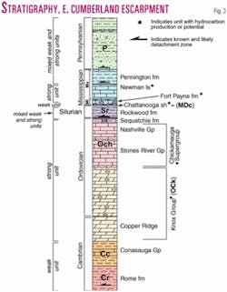
The stratigraphy of the Valley and Ridge in ETN consists of alternating weak and strong units above the Rome formation master décollement, which rests on largely undeformed basement (Fig. 3).
Above the weak Rome formation lies the Conasauga Group (mostly shale to the west). Where the Rome locally becomes either too thin or too strong, the Conasauga is the basal weak detachment layer and the oldest unit exposed along thrust faults.3 9 At the top of the Conasauga is the Maynardville limestone which, together with the massive (up to 900 m) Knox Group carbonates and the western facies of Middle-Upper Ordovician limestones, make up the 1,600-m-thick strong unit in the section.
The Middle Ordovician regional unconformity separates the Knox Group from the overlying Chickamauga Group, in which weak units sometimes act as a middle detachment horizon between the lower Rome/Conasauga and potential upper Devonian-Mississippian Chattanooga shale, Mississippian Pennington, and Pennsylvanian detachment zones.
The Chattanooga shale unconformably overlies Ordovician to Silurian rocks throughout much of ETN. The Chattanooga shale is a source of oil and gas here, and its correlatives to the northeast (the "Devonian shale") source major plays in the Appalachian basin.12 Mississippian rocks along the escarpment grade upward from carbonates and shales to dominantly clastics, and the Fort Payne formation and Newman limestone ("Big Lime") are common oil and gas reservoirs in the Cumberland plateau. The overlying Pennsylvanian deltaic sandstones, shale, and coal are deformed only in the western portions of the FTB in ETN.
Fold-thrust belt structure
The Alleghanian FTB in East Tennessee consists of up to 12 imbricate thrusts sheets with displacements ranging from a few kilometers to over 100 km. Both the number of faults and fault displacement decrease to the northeast into Virginia and southwest into Georgia and Alabama (Fig. 1).
Deformation style varies both along and across the fold belt, with folding dominating at the surface in the eastern belts, in contrast with closely spaced imbricate faulting to the west5 6 8 and increased folding again in northwest Georgia and southwest Virginia (Fig. 1).
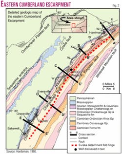
Along the eastern Cumberland escarpment, the Chattanooga fault lies above relatively shallow locally folded faults (Rockwood, Harriman, Cranmore Cove) (Fig. 2). Previous work suggested that the Rockwood-Chattanooga fault system was originally similar to the Pine Mountain block: a single thrust sheet with two major detachment levels and fault-related folding.9
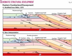
This idea was refined by adding the Cranmore Cove sheet to the Rockwood-Chattanooga system, and suggesting that the original thrust sheet had three detachment zones: the Rome formation, Silurian to Lower Mississippian shaly units, and upper Mississippian/ Lower Pennsylvanian weak units10 11 (Figs. 3 and 4).
Fig. 4a shows an earlier interpretation of structural development along the escarpment.11 First, the middle décollement was deflected into a higher zone by a blind thrust cutting from the basal Cambrian detachment into the Chickamauga Group. Then translation up the upper ramp created a short wavelength ramp anticline in Pennsylvanian and Mississippian rocks along the escarpment.
Fault lockup at this anticline forced additional movement to be accommodated by splays that developed in a foreland-to-hinterland sequence (Fig. 4a).
Interpretation
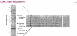
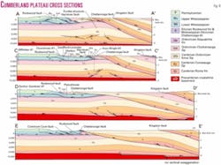
Cross sections A-A', D-D', and E-E' are based on processed industry seismic lines (Fig. 5) in addition to surface and well data (Figs. 2 and 6). Lines B-B' and C-C' were constructed using surface geologic map data and well data from the Tennessee Division of Geology oil and gas well database.13
In our cross sections, faults propagated as single thrust sheets with detachment levels in the Rome formation, Rockwood formation/Chattanooga shale, and Pennington formation, though the upper detachment steps down to the SW through a lateral ramp from Mississippian to Silurian rocks near Dayton, Tenn.
Movement on the detachment folded the Pennsylvanian rocks of the escarpment into a ramp anticline above a blind thrust that tipped out in Mississippian/Lower Pennsylvanian units. With additional shortening, several faults broke through the original thrust sheet in a foreland-to-hinterland sequence, creating imbricates and horses comprised of various parts of the lower ramp anticline (Fig. 4b), consistent with the conclusions of earlier work.10 11
Our new cross sections, however, also differ significantly from previous sections. The Chattanooga fault near Harriman, Tenn., follows a continuous ramp from the surface to the basal detachment, rather than being cut off at shallow depth by the Kingston fault (Fig. 6, Sec. A-A'), so plateau rocks with hydrocarbon potential do not extend as far under the Valley and Ridge as previously suggested.7 9 11
There is no blind thrust from the Rome to the Chickamauga that deflects the sole thrust into an upper Mississippian detachment beneath the Cumberland escarpment anticline (contrast Fig. 4a and Fig. 4b). A third shallow thrust sheet (Harriman sheet), exposed in windows through splays in the Chattanooga fault footwall, extends from Harriman to Spring City, Tenn. (Figs. 2 and 6). And finally, a detachment fold in the footwall of the Chattanooga fault, discussed below, postdates formation of the original thrust sheet and bows up both footwall and hanging-wall units and structures.
Eureka detachment fold
Many published cross sections2 7 limit footwall deformation in ETN to shallow map-scale synclines above the Knox strong unit.
Lack of seismic and well data to constrain subsurface geometry, the small amount (<10%) of internal strain in thrust sheets,14 and widespread application of structural development models not requiring footwall deformation suggested that brittle failure, bulk transport, and hanging-wall deformation dominate FTB deformation.
Seismic reflection data, however, suggest footwall deformation may be more extensive than previously thought. A fractured subthrust anticline, cored by a "mushwad"15 16 or by duplexes of Cambrian shales and carbonates,17 comprises the structural framework for Swan Creek field in Northeast Tennessee (Fig. 1), and exploration below the easternmost synclinorium of Middle Ordovician rock in ETN also suggests structural complexity near the basal detachment.18
Interpretation of industry seismic lines and well data suggests that Rome-Conasauga thickness increases in the Chattanooga fault footwall, folding the rocks above it in a long wavelength-low amplitude detachment fold that is traceable some 80 km from Harriman to Graysville, Tenn. (Fig. 2).
Deformation style changes along the length of the fold from disharmonic folding at the south end, to splaying, to development of a triangle zone to the north. In section A-A' (Fig. 6), the structure facilitating thickening of the sub-Knox Cambrian units is a triangle zone.
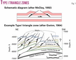
Classic Type I triangle zones19 formed in the cores of folds in the central Appalachian plateau, where blind faults dipping toward both the hinterland and foreland rise from Upper Silurian evaporite and shale into the cores of detachment anticlines20 21 (Fig. 7).
The Eureka structure beneath the Chattanooga thrust along section A-A' consists of hinterland and foreland-dipping faults in the core of the detachment fold above a single, basal detachment layer, a Type I triangle zone. Both Type I and Type II (Canadian Rockies foothills) triangle zones have been identified in the southern and central Appalachians.19 22 23
Approximately 40 km NNE of section A-A', the ARCO/Oxy No. 1 well was drilled to basement in the Chattanooga fault footwall (Fig. 1). Shallow faults (less than 1 km depth) identified in the well log and in several industry seismic lines occur in units and at depths very close to those interpreted in section A-A'.
No faults were identified in the Rome or Conasauga, however, and lower unit thicknesses in the ARCO/Oxy No. 1 well were similar to the undeformed thicknesses of these units in seismic reflection lines farther southeast.
Between sections A-A' and D-D', faulting in the triangle zone diminishes as displacement on the NW-dipping splay goes to zero and SE-dipping thrusts become dominant (Fig. 6). Farther southwest at line E-E', obvious splays off the basal detachment have disappeared, leaving only the increasing thickness of Cambrian units.
Unfortunately, small-scale internal deformation is not resolved in the seismic reflection data. Therefore, in lines D-D' and E-E', the internal deformation of the Eureka detachment fold is inferred from: (1) deformation of exposed Cambrian units, and (2) deformation of units with similar mechanical properties in an analogous structure in Pennsylvanian rocks in the Rockwood fault footwall (discussed below).
The Rome formation and Conasauga Group are commonly depicted in regional cross sections as gently dipping uniform thickness panels at the base of thrust sheets. In many locations, however, these units display complex outcrop- to map-scale folding and faulting.7 8
This scale of faulting must be present in section D-D', where splays off the basal detachment cut up into the Conasauga Group, and in section E-E', where no splays are revealed in the seismic reflection data (Fig. 6) because fault displacements are too small to account for all the thickening in the core of the detachment fold. The seismic lines, however, do not reveal substantial thickening or faulting in the Knox; instead the Knox is gently buckled above the thickened units below.
Rockwood detachment fold structure
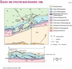
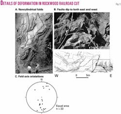
A possible outcrop- to map-scale analogue for the Eureka sub-Chattanooga detachment fold exists in Pennsylvanian plateau rocks in the Rockwood fault footwall (a shallow footwall splay of the Chattanooga fault) (Fig. 8). Highly deformed sandstone, coal and shale occur in the core of a tight anticline beneath the Rockwood fault and are well exposed in a railroad cut near Rockwood, Tenn.9 12 (Fig. 9).
Lithology in the Rockwood exposure mimics that of the Eureka subsurface detachment fold, in which a competent unit was thrust over interbedded incompetent and competent units and tightened into a detachment fold (Figs. 6 and 9), though on a scale of meters to tens of meters. Intense deformation in the interior of the shallow detachment fold is manifested in both WNW- and ESE-dipping thrusts, folds that are asymmetric in both directions, noncylindrical folds, crenulated shale, fanning of and movement on preexisting fractures in sandstone, and high vitrinite reflectance in impure coal.
Fold style varies with both lithology and bed thickness. Thin- to medium-bedded sandstones form short wavelength tight and noncylindrical folds, while massive (>1 m) beds form open, long-wavelength folds. Both WNW- and ESE-directed thrust faults broke overtightened folds (Fig. 9b).
At the east end of the outcrop, noncylindrical folds are identified by curved fold hinges (Fig. 9a), and fold plunges that reverse from south to north across the tracks (Fig. 9c). Shales deformed by folding or fracturing to accommodate the surrounding more competent sandstones are thickened in many fold hinges.
We conclude that the variety and complexity of mesoscopic deformation in the railroad cut probably mimics the subseismic-scale deformation in weak and strong units in the Eureka subsurface detachment fold and other Valley and Ridge structures.
Hydrocarbon potential
The open, linear, 80 km-long, Eureka detachment fold below the Chattanooga thrust could be a major hydrocarbon trap in the western Valley and Ridge, given the potential source and reservoir rocks in the structure.
Conodont alteration index values (CAIs) for exposed Ordovician rocks near the escarpment indicate that thermal maturity is favorable as well. CAIs are between 1.5 and 2.5, similar to those in the Swan Creek field,24 25 well inside the oil-gas window.
Although most of the approximately two dozen wells drilled near this structure have been dry, few wells on the plateau were drilled into units deeper than Mississippian, even fewer wells tested Ordovician or older units on either side of the Cumberland Escarpment, and none was optimally located and drilled near the crest of the detachment fold.16 The ARCO Wright No. 1 well drilled in Rhea County just off the crest contains both oil and gas13 (Fig. 2).
Obvious drilling targets would be the upper Knox and Stones River (Black River) and Nashville (Trenton) Groups, which are productive reservoirs in Swan Creek field in northeastern Tennessee and on the Cumberland plateau and Highland rim (Figs. 1 and 3). These reservoirs may be self sourced: The Cambrian Copper Ridge dolomite at the base of the Knox is organic rich,26 and USGS gas chromatography data27 indicate that oil from Swan Creek field has an algal (probably Ordovician) source,17 potentially from Stones River and Nashville Group rocks.
The Knox unconformity play has also been productive near the Tennessee-Kentucky border on the Cincinnati arch, where tectonically controlled fractures enhanced the reservoir28 (Fig. 1). Although primary porosity is most important in Swan Creek field, secondary fracture porosity is locally enhanced by folding and faulting.14 29
Folding of the Knox in the detachment fold may have increased fracture density, increasing the potential reservoir volume. Fracture studies in higher thrust sheets around Oak Ridge, Tenn. (Fig. 1), however, indicate most Knox Group fractures predate thrusting and that younger deformation was accommodated on existing fractures.30
A deeper, higher risk play could also be pursued in the basal Knox Group Copper Ridge dolomite. It emits a fetid odor on fresh surfaces5 30 and is productive in north-central Ohio fields.28
Intervals in the Stones River Group produce oil in Swan Creek field,29 whereas the Trenton Group has produced oil since 1943 in Rose Hill field on the Powell Valley anticline in southwestern Virginia31 (Fig. 1). Both groups are productive farther north in Kentucky and Tennessee in many wells along the Cincinnati arch and in three gas fields developed in the late 1970s and early 1980s on the Cumberland plateau and Highland rim 40-75 km west of the Chattanooga fault.13
References
1. Rodgers, J., "The tectonics of the Appalachians," Interscience Publishers, New York, 1970, 271 pp.
2. Roeder, D., Gilbert, O.E., Jr., and Witherspoon, W.D., "Evolution and macroscopic structure of Valley and Ridge thrust belt, Tennessee and Virginia," University of Tennessee, Department of Geological Sciences, Knoxville, 1978, 25 p.
3. Hatcher, R.D., Jr., Thomas, W.A., Geiser, P.A., Snoke, A.W., Mosher, S., and Wiltschko, D.V., "Alleghanian orogen", in Hatcher, R.D., Jr., Thomas, W.A., and Viele, G.W., eds., "The Appalachian-Ouachita orogen in the United States," GSA, Boulder, 1989, pp. 233-318.
4. Rich, J.L., "Mechanics of low-angle overthrust faulting as illustrated by the Cumberland thrust block, Virginia, Kentucky, and Tennessee," AAPG Bull., 1934, Vol. 18, pp. 1,643-54.
5. Rodgers, J., "Geologic map of East Tennessee with explanatory text," Tennessee Division of Geology, Nashville, 1953, 168 pp.
6. Harris, L.D., and Milici, R.C., "Characteristics of thin-skinned style of deformation in the Southern Appalachians, and potential hydrocarbon traps," US Geological Survey Professional Paper 1018, 1977, 40 pp.
7. Woodward, N.B., "Valley and Ridge thrust belt: Balanced structural sections, Pennsylvania to Alabama," University of Tennessee Department of Geological Sciences, Knoxville, 1985, 64 pp.
8. Hardeman, W.D., "Geologic map of Tennessee," Tennessee Division of Geology, Knoxville, scale 1:250,000, 1966.
9. Swingle, G.D., "Geologic map and mineral resources summary of the Rockwood Quadrangle, Tennessee," Tennessee Division of Geology, scale 1:24,000, 1960.
10. Milici, R.C., and Leamon, A.R., "Cranmore Cove-Chattanooga fault system: A model for the structure along the Alleghany front in southern Tennessee," Geology, Vol. 3, 1975, pp. 111-113.
11. Milici, R.C., "Structural geology along the Eastern Cumberland Escarpment, Tennessee; a second look," Southeastern Geology, Vol. 21, 1979, pp. 3-16.
12. Milici, R.C., "Upper Devonian fractured black and gray shales and siltstones," in Roen, J.B., and Walker, B J., eds., "The atlas of major Appalachian oil and gas plays," West Virginia Geological & Economic Survey, 1996, pp. 86-99.
13. Faust, E., Tennessee Division of Geology oil and gas well database, 1998.
14. Lutz, C.T., "The gap between total strain and total strain in carbonates in foreland thrust sheets; an example from the southern Appalachians," GSA Abstracts with Programs, Vol. 19, 1987, p. 752.
15. Thomas, W.A., "Mushwad; ductile duplex in the Appalachian thrust belt in Alabama," AAPG Bull., Vol. 85, 2001, pp. 1,847-69.
16. Tavernier, S.A., "Basement Faults in the East Tennessee Seismic Zone: Observations from the Area of the Swan Creek Field," unpublished MS Thesis, University of Tennessee, 2001, 46 pp.
17. Hatcher, R.D. Jr., Williams, R.T., and McCown, M.W., "Swan Creek field: Isolated success or tip of the iceberg?," OGJ, Oct. 1, 2001, pp. 38-44.
18. Hatcher, R.D. Jr., Whisner, J.B., and McCown, M.W., "3-D structure beneath the Middle Ordovician Tellico-Sevier synclinorium, SE and NE Tennessee," GSA Abstracts with Programs, Vol. 33, 2001, p. A-18.
19. Couzens, B.C., and Wiltschko, D.V., "The control of mechanical stratigraphy on the formation of triangle zones," Bull. of Canadian Petroleum Geology, 1996, Vol. 44, pp. 165-179.
20. Gwinn, V.E., "Thin-skinned tectonics in the Plateau and northwestern Valley and Ridge provinces of the Central Appalachians," GSA Bull., 1964, Vol. 75, pp. 863-900.
21. Schumaker, R.C., Wilson, T.H., Dunne, W.M., Knotts, J., and Buckley, R., "Chapter I-Pennsylvania, Virginia, and West Virginia sections," in Woodward, N.B., ed., "Valley and Ridge thrust belt: Balanced structural sections, Pennsylvania to Alabama," University of Tennessee Department of Geological Sciences, Knoxville, 1985, 64 pp.
22. Wilson, T.H., and Schumaker, R.C., "Broad Top thrust sheet: An extensive blind thrust in the central Appalachians," AAPG Bull., 1992, Vol. 76, pp. 1,310-24.
23. Hatcher, R.D., Jr., and Whisner, J.B., "Deformation in the core of the Southern Appalachian triangle zone," GSA abstracts with programs, Vol. 30, 1998, p. 234.
24. Epstein, A.G., Epstein J.B., and Harris, L.D., "Conodont color alteration—an index to organic metamorphism," US Geological Survey Professional Paper 995, 1977, 27 pp.
25. Orndorff, R.C., Harris, A.G., and Schultz, A.P., "Reevaluation of conodont color alteration patterns in Ordovician rocks, east-central Valley and Ridge and western Blue Ridge provinces, Tennessee," US Geological Survey Bull. 1839, 1998, 10 pp.
26. Whisner, J.B., and Hatcher, R.D., Jr., "Assessment of hydrocarbon potential of the region immediately surrounding and including property in Anderson, Roane, Morgan, and Campbell Counties, Tennessee," prepared for Coal Creek Mining & Manufacturing Co., University of Tennessee, Knoxville, 1998, 13 pp.
27. Robert Burruss, USGS, written communication, 1998.
28. Baranoski, M.T., Riley, R.A., and Wolfe, M.E., "Play [Ok; Cambrian-Ordovician Knox Group unconformity play," in Roen, J.B., and Walker, B J., eds., "The atlas of major Appalachian oil and gas plays," West Virginia Geological & Economic Survey, 1996, pp. 181-187.
29. Clendening, J.A., and McCown, M.W., "Swan Creek field: Potential giant develops in Tennessee," OGJ, Apr. 19, 1999, pp. 95-99.
30. Hatcher, R.D. Jr., Dreier, R.B., Foreman, L., Ketelle, R.L., Lee, R., Lee, S.Y., Lietzke, D.A., Lemiszki, P.J., and McMaster, W.M.," Status report on the geology of the Oak Ridge Reservation: Oak Ridge National Laboratory TM-12074," 1992, 244 pp.
31. Miller, R.L., and Fuller, J.O., "Geology and oil resources of the Rose Hill District—the fenster area of the Cumberland overthrust block-Lee County, Virginia," Virginia Geological Survey, Bull. 71, 1954, 383 pp.
The authors
Jennifer Whisner is a graduate student in structural geology at the University of Tennessee in Knoxville, working on a 3D reconstruction of part of the Appalachian Valley and Ridge. She holds an MS degree from Western Michigan University.
Robert D. Hatcher Jr. (bobmap @utk.edu) is a scientist and professor at the University of Tennessee. He is a structural/ tectonics geologist who has worked for more than 35 years in the Appalachians after spending a year in New Orleans with Humble Oil & Refining Co., now ExxonMobil Corp. The National Science Foundation, Department of the Interior, and private industry support his research, and the US Department of Energy's National Petroleum Technology Office recently provided additional assistance.
