Managing Data & Knowledge: Multidisciplinary teams, integrated software for shared-earth modeling key E&P success
Synergistic multidisciplinary teams that use advanced integrated interpretation software and project workflows are critical in the development of an accurate shared-earth model for exploration or development projects.
Such a model incorporates data from all disciplines in real-time. Recent developments in software integration are beginning to allow the use of a single database to store and use for real-time geological, geophysical, and engineering data.
This database is, in effect, the beginning of a shared-earth model. The methods used are integrated into the software and team activities through specific project workflows designed to meet the objectives of each project.
Through the development and application of a shared-earth model, and with the use of advanced software and a synergistic approach, teams can:
- Generate viable, high-quality, three dimensionally valid subsurface interpretations and prospects.
- Reduce cycle time.
- Increase the effectiveness of the integrated process.
- Find oil and gas, thereby adding value to the bottom-line of an exploration or development program.
Shared-earth model
Because geologists, geophysicists, and reservoir and drilling engineers all work with a single earth, the model each discipline develops must be compatible with the model of every other discipline if it is to be correct. A shared-earth model is a single model of a portion of the earth that seamlessly incorporates the observations, interpretations, and data of each specialist involved in its development.
The requirement that a correct model incorporate data from all disciplines seems obvious but is a requirement often overlooked. For example, most geophysicists incorporate into their interpretation log tops picked by geologists.
Fault cuts identified by geologists on well logs are less frequently used, but faults observed in a well log should be visible on seismic if the missing section is greater than the resolution of the seismic data. Too often, fault cuts are not used by geophysicists to aid in the identification of subtle or complicated faulting.
The reverse is also true. Geologists rarely check with geophysicists to see if seismically visible faults cut wellbores. If a fault is interpreted on seismic to cut a wellbore, the fault should either be observable by correlation in the well log or the seismic interpretation is incorrect.
Too few geoscience teams actually perform these crosschecks to verify the accuracy of their shared-earth model.
Crosschecking fault cuts in well logs with faults observed on seismic offers additional information about the velocity field used in the model. Fault cuts that are clearly observed in well logs and on seismic data but do not tie may indicate that the velocity model being used to relate seismic time to depth is incorrect.
Adjusting the velocity model to allow the well data to tie the seismic data improves the entire model.
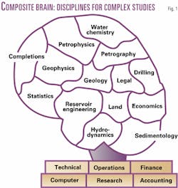
Many problems addressed by the petroleum industry require specialized knowledge about too many subjects to be adequately addressed by an individual. The need for multiple specialists has led to creation of multidisciplinary teams in many exploration and production companies.1 These teams can either function linearly or synergistically to form what we term a "composite brain" (Fig. 1).
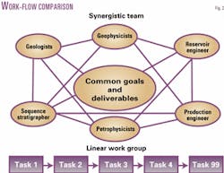
If teams function linearly, each discipline works separately and sequentially. In the case of a multidisciplinary team studying a mature area, the geologist first correlates the well logs and develops a general depositional model. The log tops are transferred from the well logs to the seismic data with some velocity model.
The geophysicist uses the log tops to aid his interpretation of the seismic data. If any discrepancies arise between the log interpretation and the seismic interpretation, the geologist may modify the geologic interpretation, as required.
Once the geologist and geophysicist have reached a consistent interpretation, structure and isochore maps are generated. These maps are passed along to the reservoir engineer who compares well performance with volumetric estimates of reserves.
If any production anomalies are identified, the geologist and geophysicist may review and modify their work again, as necessary.
Once production anomalies are resolved, the geologist, geophysicist, and reservoir engineer identify any remaining potential. Drilling targets are passed along to the drilling engineer who plans the well and estimates the drilling and completion costs.
The well plan is passed back to the geologist who plots where the well will intersect each mapped horizon and fault. The reservoir engineer determines the current pressure of any reservoir intersected by the well and passes this information back to the drilling engineer.
The drilling engineer may modify the well plan and cost estimate to deal with the any unexpected drilling problem such as drilling through depleted reservoirs. The reservoir engineer runs economics on the final cost estimate.
If the economics are favorable, the project proceeds; if not, a new set of drilling targets may be passed to the drilling engineer to start the process again.
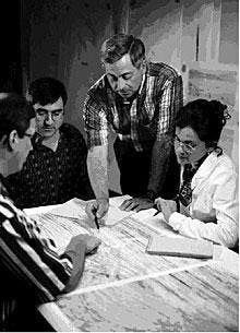
By contrast, in the workflow of a synergistic multidisciplinary team (Fig. 2), work is done in parallel rather than in sequence, and information flows in all directions in much the same way that different parts of our "Composite Brain" function together.2
The geologist, geophysicist, and reservoir engineer all work on their tasks simultaneously, sharing information and discussing problems. A well plan is developed within the shared-earth model generated by the team.
As the well path is modified to maximize drilling efficiency, the team members observe where it intersects faults and depleted reservoirs. The drilling engineer has real-time feedback from the team regarding the well plan.
The power of a synergistic team not only lies in more effectively accomplishing the same set of tasks as the linear team, but also is unleashed when one team member observes something that explains another team member's data, opening the way for new concepts.
In short, synergistic teams find answers to questions that linear teams never recognize, just as humans can recognize problems and solutions using all senses that no individual sense could recognize alone.
Proven philosophy
One exploration team can be successful at finding hydrocarbons in a specific area, while another team working this same area is not. One team can produce a superior technical product resulting in the successful discovery of oil or gas, while another team produces mediocre or below-average results that end up as dry holes.
When investors place their risk dollars into exploration or development prospects, they need to consider the philosophy and methods that went into the project; in other words, people, not computers, find oil and gas.
The technical philosophy and methods of exploration and development used by a team or individual are important in success. Decades of research, observation, and analysis indicate that the success of some individuals, teams, or companies directly results from the technical philosophy and methods used.3 It is not serendipity, luck, or guesswork that finds hydrocarbons.
The philosophical doctrine of subsurface interpretation and mapping presented here provides the best-proven process for finding and developing hydrocarbons. It requires common sense, a certain technical background, experience, logic, and application of proven scientific methods.
This philosophy integrated into advanced geoscience and engineering software is the winning combination for an exploration and production company.
- All surface interpretations must be geologically and geometrically valid in three dimensions.
- An interpreter must have a fundamental, classic education in geology and a strong background in structural geology for a tectonic setting being worked.
- Sufficient planning, time, and detail are required to generate reliable prospects.
- All surface data must be used to develop a reasonable and accurate subsurface interpretation.
- Accurate correlations (well log and seismic) are required for reliable geologic interpretations.
- Use of correct mapping techniques and methods is essential to generate reasonable and correct subsurface interpretations.
- All important and relevant geologic surfaces must be mapped and those maps integrated to arrive at a reasonable and accurate subsurface picture.
- Mapping of multitude horizons is essential to develop reasonable correct, three-dimensional interpretations of complexly faulted areas.
- Balanced cross sections are required to prepare a reasonably correct restoration of complexly deformed structures.
- All work should be documented.
Details of this philosophical doctrine are discussed elsewhere.4 5
Role of software
Properly designed software is of enormous value to the effective functioning of a synergistic team, acting as the neurons of the composite brain. The advantages of interpretation software have been most widely recognized by geophysicists who have used it to make the two-dimensional interpretation of 3-D seismic data much more efficient.
Recent advances in geophysical interpretation software have begun to allow true three-dimensional interpretation of 3-D seismic data, promising additional gains in productivity. Reservoir engineers have also eagerly embraced software for the creation of production databases, projecting decline curves and calculating economics.
Geologists have lagged in their use of computers for several reasons, including the lack of digital log databases, limited computer proficiency, and primitive software design. All of these problems are being addressed with solutions forthcoming, and with them the geologists can expect a significant increase in productivity.
Recent developments in software integration are beginning to allow the use of a single database to store all information about a field, including real-time geophysical, geological, and engineering data. This database is, in effect, a shared-earth model.
Work done by one team member in picking log tops and seismic horizons or designing a well path is instantly available to all other team members. Team members no longer must consciously share data; all data are available to all members of the team through the common database.
Methodology vs. software
Although many geoscientists understand or have been trained in the proven philosophy and methods for finding and developing oil and gas, there is difficulty applying that knowledge in the workstation environment.
It is one thing to know the buttons, another to know how to maneuver within the programs, but the key to finding and developing oil and gas resources resides in following a proven philosophy and applying the appropriate methods and geoscience principles to generate an integrated subsurface interpretation in the workstation environment.
Research has revealed that many interpreters use a very limited set of available workstation software. When asked why, they generally answer:
- The software does not do things as a geoscientist does.
- They are unfamiliar with how best to use all the various software packages in an integrated subsurface interpretation manner.
- They cannot apply a given methodology to the appropriate software to deliver an integrated interpretation.
There are four goals to exploration and production:
- Generate viable, high-quality, three-dimensionally valid subsurface interpretations and prospects.
- Reduce cycle time.
- Increase the effectiveness of the integrated interpretation process.
- Find oil and gas.
When these goals are met, they add value to any exploration and development program.
How can we resolve the problem of limited software use and meet the four exploration and production goals? We must develop sophisticated workstation-computer software that functions in a geologic manner: how geoscientists do their work (Fig. 3).
Such software must combine the steps of a proven geologic philosophy with the right methods and techniques to conduct an integrated geologic subsurface interpretation process directed to find and develop oil and gas resources.
Software has come a long way in the past decade. We can do more to advance the software capabilities to follow the methodologies and techniques in an integrated geologic subsurface interpretation process. This helps both the software developers and the upstream petroleum companies.
Earmarks of successful teams
Even well designed software will not automatically turn every multidisciplinary team into a synergistic team. Successful synergistic teams result from careful planning, training, experience, and nurturing. Successful synergistic teams share several common characteristics (Fig. 4).
- Common objectives, deliverables. An effective team needs clearly defined direction and measurable results. Management must provide the people, tools, overall goals, and direction of a project. It is then up to the team to apply its collective knowledge and skills to define the common goals, objectives, and deliverables.
- Planning. The entire multidisciplinary team must be involved in project planning. Once the overall objectives and deliverables are defined, each person must add his or her thoughts to a final project plan.
Proper planning identifies tasks on the critical path, ensuring that one part of the multidisciplinary team is not waiting for results from another part of the team. Planning is not only essential for organizing complex tasks, but regular planning meetings also foster communication within teams.
- Communication. Successful synergistic teams have excellent communication among team members. Well-designed and integrated software can aid in this communication but is not enough.
Our experience has shown that physical proximity is critical in fostering communication within a team. Ideally, all team members should be in a single large room or common area that contains the necessary computers and data resources for them.
When team members are physically close, information and ideas flow freely between team members. They feed off each other's energy and ideas, leading to breakthroughs in understanding.
When team members are dispersed, the tendency is to wait until it is convenient to share observations or request cooperation. Frequently, it can be days or weeks before observations are shared; occasionally critical observations or questions may even be forgotten. Progress is steady but slow and breakthroughs are rare.
If team members do not work in a single team room, we recommend establishing a common area with individual offices close by to make communication as easy and rapid as possible.
- Interdependency. To develop an accurate shared-earth model, multidisciplinary teams must implement their plan, performing complex tasks with a high degree of interdependence. The total project success depends on each team member for success. What each team member does affects the others; rather than performing as separate individuals in an independent linear process, the team must exhibit interdependency.
- Management support. Management support is essential for a successful synergistic team. Once management has created a team, clearly articulated its goals, and provided the necessary resources, the team must have the autonomy and authority to accomplish its goals. Micro-managing multidisciplinary teams is likely to prove stultifying, preventing synergy from ever developing. Choose your team members wisely and get out of their way.
The upstream petroleum industry is rapidly moving toward development of an accurate shared-earth model, the corporate values of which are added value and reduced costs. The added value is in finding more oil and gas resources, while reducing costs through fewer dry holes, faster project completion, and more accurate results.
References
- Tearpock, D. J., Synergistic Team Organization/Field Study Methodology, (A Short Course). Houston: Subsurface Consultants & Associates, 1994.
- Spiegel, J., and Torres, C., Manager's Official Guide to Team Working. Lafayette, La.: Pfeiffer & Co., 1994.
- Tearpock, D.J., Bischke, R.E., and Brewton, J.L., Quick Look Techniques for Prospect Evaluation. Lafayette, La.: SOG Press, 1994.
- Tearpock, D.J. and Bischke, R.E., Applied Subsurface Geological Mapping. Inglewood Cliffs, NJ: Prentice Hall, 1991.
- Tearpock, D.J., and Bischke, R.E., Applied Subsurface Geological Mapping, 2nd Edition. Inglewood Cliffs, NJ: Prentice Hall, to be published in 2002.
The authors
Daniel J. Tearpock is chairman and CEO of Subsurface Consultants & Associates LLC, Houston, which he founded in 1988. He is an active member of many societies, including American Association of Petroleum Geologists, and is a certified petroleum geologist and advisory board member of the division of professional affairs of the AAPG. He was a finalist in 1996 and 1998 for the Ernst & Young Entrepreneur of the Year program and in 1998 received the Distinguished Service Award from Bloomsburg University, Bloomsburg, Pa. He holds a bachelors (1970) from Bloomsburg University and a masters (1977) from Temple University, Philadelphia.
James C. Brenneke is vice-president for technology at Subsurface Consultants & Associates where he supervises and advises consultants on study plans and other consulting projects. Before joining the company, he was employed with the Royal Dutch Shell Group on a variety of international exploration and production assignments. He holds a BA (1972) in geology from Augustana College, Rock Island, Ill., an MS (1976) in geology from the University of Illinois where he also pursued PhD studies in 1977.
