Groundwater seems not to influence BTEX surface geochemistry
A study of the effects of water saturation thickness changes on hydrocarbon concentra- tion at the surface requires an appropriate measuring technique. In the present analysis, near-surface measurement of benzene, toluene, ethylbenzene, and xylene (BTEX) gases were used to detect the presence of oil at depth. Since such gases are components of the trapped oil, they offer a direct indication of oil in place rather than an indirect chemical or physical change caused by vertical oil migration.
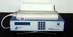
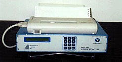
The instrument used, the MSI-301 (Fig. 1), is field portable and can measure BTEX gases to parts-per-billion (ppb) accuracy on a 6-min cycle. Soil gas is drawn from a 30 in. by 3/4 in. hole and injected immediately into the sample port. Analysis results are posted on the field map to facilitate placement of subsequent sample sites. This procedure minimizes open-ended anomalies and unnecessary background, or barren, samples.
Pilot study
A pilot study established the effectiveness of the MSI-301.
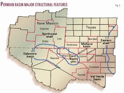
Three major companies contracted to gather data in the Permian Basin (Fig. 2) prior to a 22-well wildcat drilling program.1 Subsequent production data from discoveries in the pilot study indicated 19 correct outcomes in 22 wells, or an 86% predictive accuracy.
Some "discoveries" projected in the study to be dry proved to be noncommercial wells, so the present practice with this technique indicates which wells will be commercial discoveries as opposed to dry or marginal outcomes. Experience with some 5,000 new stations since the pilot study continues to validate an 86% accuracy of prediction.
With this kind of instrumental reliability, it was possible to examine aquifer thickness variations and their effects on BTEX concentrations and oil exploration. One of the most-asked questions about BTEX surface geochemistry is, "Does groundwater affect the migrating BTEX gases?" The present study was conducted to provide a possible answer to that question.
West Texas aquifers
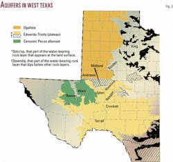
Fig. 3 shows the aerial extent of the Ogallala aquifer and that of the three other aquifers present in the Permian Basin.2
The Cenozoic Pecos alluvium aquifer in both the Delaware basin and the southern Central Basin platform is sourced from the Davis Mountains; the Trinity or Plateau aquifer runs through the Midland basin and southern Eastern shelf; and the Seymour lies under the northern Eastern shelf.
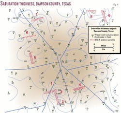
A large body of published data exists on the Ogallala, which is thicker than the other aquifers and varies more in its saturation thickness. In Dawson County the range is zero to 260 ft (Fig. 4). The Lamesa Water District gathered the water well data, and an aquifer thickness isopach was contoured and controlled by some 200 water wells across the county.3 Hence the study concentrated exclusively on the Ogallala rather than its sister aquifers.
The Ogallala aquifer extends from its source on the east flank of the Rocky Mountains into West Texas. It rests unconformably on Triassic redbeds. The underlying topography causes abrupt changes in the thickness of the reservoir that appear on the isopach.
The thick areas were often the sites of drainage systems on the Triassic surface with attendant coarse clastics. Sample studies of water well cuttings indicate that thick areas also contain some clays.
Dawson County is a solid producer of oil from the San Andres through the Lower Paleozoic reservoirs. It contains a wide variety of trap types and thus is an ideal test bed to ascertain the possible effects of aquifer thickness variations on vertical migration of oil microseeps.
Present study
The working hypothesis of the study was that thicker water saturation zones would dissolve larger amounts of BTEX gases than thinner zones and thus distort interpretative validity.
Since benzene is the most soluble gas in water at 1,800 parts-per-million (ppm), it should therefore be most severely affected by an aquifer. This would be followed by toluene at 550 ppm and ethylbenzene at 110 ppm.
An alternative hypothesis might be that sections of the thin water saturation speed the passage of Ogalalla water from one thin section to another with a higher velocity than in the thick areas. If so, water with low aromatic concentrations at the thin areas would take in more aromatics than slower moving water in thick zones.
Samples were taken at 1/3-mile intervals as opposed to the exploration practice of taking samples on a 0.2-mile grid based on a GPS location system. These profiles are plotted in forthcoming figures to show aquifer variations at the bottom of the chart with benzene, toluene, and ethylbenzene concentrations at the top.
The MSI-301 registers anomalies indicative of oil accumulations with values at least 100% higher than those levels found in barren areas. To be designated "productive," a site must show benzene and at least one of the other two one-ring aromatic compounds as anomalous. Therefore changes in concentration due to saturation thickness must exceed 100% to be detrimental to accurate prediction of production.
Measurements
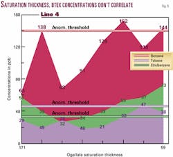
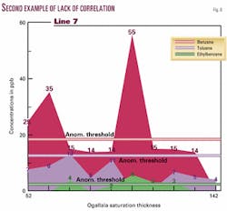
Lines four (Fig. 5) and seven (Fig. 6) are shown as examples from the series of nine profiles run in Dawson County. Although saturation thickness varies by nearly 300% along the profiles, there is no discernible corresponding effect on BTEX concentrations.
The other seven profiles show similar results.
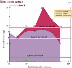
Line eight (Fig. 7) is noteworthy in that it contains an undrilled BTEX anomaly. The aquifer thickens from 75 ft on the west to 127 ft on the east but causes no appreciable effect on the benzene and toluene concentrations. However, stations 63 through 66 are anomalous for both benzene and toluene.
Based on the line profiles of this project, both hypotheses were proven untrue. The saturation thickness has no discernable effect on BTEX values at the surface.
Another frequently asked question concerns the possibility of horizontal movement of surface anomalies as a result of ground water movement. The surface of the water table in Dawson County dips 400 ft from northwest to southeast with a slope of 9.7 ft/mile, causing the water to move in that direction, so the area provides an ideal setting for detecting any horizontal displacement.
Groundwater movement
To calculate the possible displacement of vertical seepage by groundwater, we had to modify Darcy's Law Q=KAI.4
In this law Q equals the discharge of groundwater in cubic feet per day, K equals hydraulic conductivity in feet per day, A equals the cross-section area through which discharge occurs, and I equals the gradient in feet per mile.
This equation had to be modified to express the flow in terms of velocity. Q=KAI was modified to Q/A=KI and then expressed as Darcian velocity (Q/A)=(KI/n), which is average groundwater velocity in feet per day.
The High Plains Water Board5 supplied valuable data to solve this equation. K equals 20 ft/day, n (porosity) equals 17%, and gradient equals 9.7 ft/mile. Substituting into the equation to solve for (Q/A) we have (Q/A) = [(20)(9.7)]/0.17, which is 0.216 ft/day or 78.8 ft/year.
Movement of gases
To quantify vertical movement of gases, the study referred to Alton Brown in his pivotal paper on vertical migration.6
Brown accumulated published measurements of ascent velocities ranging from 100 to 1,000 m/year. He also performed valuable calculations on a single-phase gas model incorporating Reynolds number, fracture width and angle, and Brownian motion.
For a fracture width of 20 micrometers, the vertical ascent equals 100 m/year. Thus the BTEX gases can pass through the thickest Ogallala interval in Dawson County in less than a year at the slowest rate or one month at the highest rate. This calculation implies a horizontal signal shift of no more than 78 ft, which is insignificant for purposes of the study.
Not universal
The truism that no exploration technique works everywhere applies to the BTEX technique.
Holysh and Toth7 describe an area in Alberta, Canada, with numerous recharge and discharge areas dispersed over a nine-township study. Soil gas (including BTEX) anomalies are absent over oil fields in the recharge areas (downward moving water) yet strong in barren zones of discharge areas (upward moving water).
No geochemical method presently available would apply to a region like this. Holysh also describes discrepancies in soil gas results in artesian environments that could present problems in projects near Balmorhea, Tex., and Artesia, NM.
Key findings
Apparently the vertical flow of oil has stabilized over geologic time to minimize the effects of BTEX solubility or movement in ground water.
The alkanes are far more soluble in water than are BTEX compounds (methane is soluble in water up to 35,000 ppm), so that group of oil components cannot be included in the findings associated with this study.
The mobility of the BTEX gases decreases in direct proportion to their solubility in water. The increased chemical activity for benzene tends to counteract solubility losses into the water. Benzene molecules diffuse more rapidly than toluene and ethylbenzene, thus traversing the saturated interval more rapidly.
The Ogallala is not a homogenous formation but rather a mixture of all the soil types in any fluvial system. The isopach of Ogallala saturation thickness (Fig. 4) is not a precise reservoir isopach but a close approximation; effects on vertical or horizontal migration cannot be expected to correspond exactly to saturation thickness.
In addition, McReynolds4 pointed out that during irrigation season a local depression of the water table occurs around producing water wells and affects horizontal water movement.
A further caution in utilizing the material presented here arises from the fact that these examples are taken from the most extreme thickness variations in the county. This is apparent on Ogallala maps available on counties north of Dawson from the High Plains Underground Water Conservation District in Lubbock.
By contrast the Trinity-Plateau aquifer8 thickens slowly and smoothly to the south and east with few rapid changes. The gradient also slopes to the southeast at about 5 ft/mile. These conditions indicate even less effect on BTEX readings than the Ogallala.
In summary, based on a limited sample, there seems to be little effect on surface BTEX measurements caused by groundwater variations, either vertically or horizontally, as a result of either horizontal movement or variation in aquifer thickness.
References
- Calhoun, G.G., and Hawkins, J., "BTEX detector's results good in oil identification," OGJ, Mar. 30, 1998, p. 77.
- Texas Water Development Board, Austin, January 1994.
- Everhart, Harvey, Lamesa Water District, Lamesa, Tex.
- Darling, Bruce, L.B.G.-Guyton Associates, Austin, Tex., personal communication, 2000.
- McReynolds, Don, High Plains Water Board, Lubbock, Tex., personal communication, 2000.
- Brown, Alton, "Evaluation of possible gas microseepage mechanisms," AAPG Bull., Vol. 84, No. 11, November 2000.
- Holysh, Stephan, and Toth, Jozef, "Flow of formation waters: Likely cause for poor definition of soil gas anomalies over oil fields in east-central Alberta, Canada," AAPG Memoir 66, 1994, pp. 255-307.
- Bush, P.W., "Hydrogeologic Framework of the Edwards-Trinity Aquifer System, West-Central Texas," US Geological Survey Professional Paper 1421-B, 1996.
The authors
James Hawkins manages the Midland, Tex., office of New Paradigm Exploration Inc. He developed the technical aspects of the BTEX detector for field use in petroleum exploration. Work with the BTEX detector formed the basis for his master's thesis in geology at the University of Texas of the Permian Basin.
Gerald G. Calhoun formed New Paradigm in 1986 to generate prospects and consult on surface exploration. Before that he was with Pennzoil Co., Texaco, and Humble Oil & Refining Co. He has a BS degree in geological engineering from the University of Oklahoma.
