Tucumcari basin potential borne out in new source rock studies
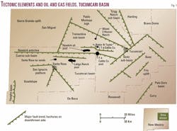
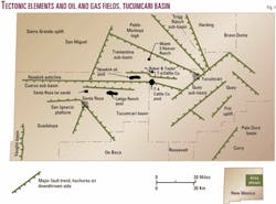
The Tucumcari basin of east-central New Mexico (Fig. 1) is an asymmetric structural depression that existed as a depositional basin from the Atokan (Early Pennsylvanian) through Wolfcampian (Early Permian) time.1 2 The basin covers 5,000 sq miles.
To the north and northwest, the Sierra Grande uplift separates the Tucumcari basin from the Pecos shelf. To the northeast, the Bravo dome separates the Tucumcari basin from the Dalhart basin of the Texas and Oklahoma panhandles. On the east, the Frio uplift separates the Tucumcari basin from the Palo Duro basin. To the south, a gentle arch separates the basin from the northwest shelf of the Permian basin. To the west, the San Ignacio platform of Reynolds and Reynolds3 separates the Tucumcari basin from the Vaughn basin.
Deepest parts of the Tucumcari basin are in elevator basins along the northern margin of the basin in Guadalupe, San Miguel, and Quay counties.2 They are referred to as the Cuervo, Quay, Trementina, and Trigg Ranch sub-basins (Fig. 1). In these elevator basins, depth to Precambrian may exceed 12,000 ft. On shelf areas to the south, depth to Precambrian is less than 7,000 ft. On uplifted areas to the north, northwest, and northeast, depth to Precambrian rarely exceeds 3,000 ft.
Major faulting that led to the formation of the Tucumcari basin and its component elevator basins is Atokan (Early Pennsylvanian) through Wolfcampian (Early Permian) in age. The Tucumcari basin and its bordering uplifts are tectonic components of the ancestral Rocky Mountains.
This article represents a much larger data base of source rock data collected since publication of OGJ articles in January 2001.1 2
Basin fill
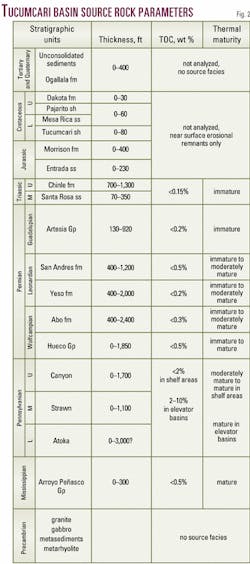
Sediments that infill the Tucumcari basin are Mississippian through Quaternary in age (Fig. 2). Mississippian strata are pre-basinal shelf carbonates and sandstones.
Pennsylvanian and Wolfcampian (Lower Permian) strata are synorogenic. Internal facies variations in these strata reflect proximity to the tectonic highlands of the ancestral Rocky Mountains that acted as source areas for sediments deposited in the basin.
Coarse arkosic conglomerates (granite wash) are prevalent adjacent to the Sierra Grande uplift and Bravo dome in the north. Interbedded fine-grained sandstones, black to red shales, and shallow-marine limestones occupy shelf areas to the south. Pennsylvanian and Lower Permian strata thicken dramatically in the elevator basins where they are comprised of dark-gray to black shales and interbedded coarse arkosic sandstones.
Thickness of the Pennsylvanian section may exceed 4,000 ft in the elevator basins but is generally less than 1,500 ft on the shelf areas.
Wolfcampian strata also thicken into the elevator basins and are also synorogenic. Facies are similar to the Pennsylvanian in that conglomerates and coarser-grained sediments are found in the northern part of the basin near the Sierra Grande uplift and Bravo dome and finer-grained sediments and carbonates predominate in the south. Wolfcampian shales in the basin are mostly light-gray to red in color.
Post-Wolfcampian strata were deposited after the tectonic movements that formed the elevator basins ceased. Their thickness patterns and internal facies variations seem little affected by the tectonic framework of the basin.1
Petroleum source rocks
Pennsylvanian strata contain the most significant petroleum source rocks in the Tucumcari basin (Fig. 2). Underlying Mississippian strata, although thermally mature, contain insufficient total organic carbon (TOC) for petroleum generation. Shallower strata of Permian age and younger either contain insufficient TOC for major petroleum generation or are thermally immature.
Source facies within the Pennsylvanian are dark-gray to black shales.4 On the shelf areas, these are interbedded with sandstones and limestones. In the elevator basins, they are interbedded with the coarser sandstones and conglomerates derived from the uplifts to the north.
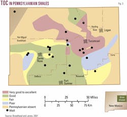
The Pennsylvanian shales contain enhanced levels of TOC within the elevator basins (Fig. 3). On the shelf areas, the shales typically contain 1 to 2% TOC. In the elevator basins, Pennsylvanian shales contain 2 to 10% TOC. Because the shale sections in the basins are thicker and significantly enriched in TOC, they will have yielded substantially more hydrocarbons than on the shelf areas. Thin coal beds have also contributed to the generation of hydrocarbons in the elevator basins.
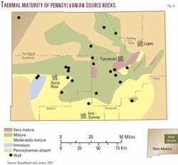
Thermal maturity of Pennsylvanian source facies is greater in the elevator basins than on the shelf areas (Fig. 4). This is mainly a result of the greater depth of burial within the basins. Within the elevator basins, most of the Pennsylvanian section is within the oil window. In the deepest areas, the Pennsylvanian may be in the condensate-wet gas window. On the shelves, Pennsylvanian strata are moderately mature to mature and are generally in the uppermost part of the oil window.
Petroleum occurrences
The Tucumcari basin contains four discovered but unexploited occurrences of oil and gas. Two of these occurrences, the Newkirk oil pool and the Santa Rosa tar sands, are at depths of 600 ft or less in basal Triassic sandstones.
The heavy oil in these accumulations is thought to have been generated in Pennsylvanian source rocks and migrated into the basal Triassic sandstones through major high-angle faults that form the boundaries of the elevator basins.2 5 6 After emplacement of the oil, it was biodegraded and became heavy.
The two other oil and gas accumulations, the Latigo Ranch and T-4 Ranch pools, occur in Pennsylvanian sandstones within the Cuervo sub-basin.1 7 These fields were discovered in the early 1980s but were never exploited for economic and technical reasons. Nevertheless, they indicate that gas and light oil-condensate were generated and trapped in the Cuervo sub-basin. Several other wells drilled within the elevator basins have also encountered shows of oil and gas in Pennsylvanian sandstones.1 4 These petroleum occurrences, coupled with the documented existence of significant source rocks, indicate considerable potential for oil and gas within the Tucumcari basin.
Summary
Pennsylvanian strata within the Tucumcari basin contain good to excellent source rocks of oil and gas. Optimum thermal maturity and TOC are found in deep elevator basins in the northern part of the Tucumcari basin.
Depth to Precambrian may exceed 12,000 ft in the deepest parts of these elevator basins. Dark-gray to black shales that are the source rocks of gas and light oil-condensate found in the two unexploited fields located within the elevator basins.
Acknowledgments
The New Mexico State Land Office (Dr. Ray Powell Jr., New Mexico Commissioner of Public Lands) funded the work for this project. Appreciation also goes to Karl Frisch, Glen Jones, Leo Gabaldon, and Kathy Glesener of the New Mexico Bureau of Geology and Mineral Resources for help in map preparation and drafting. Heidi Justman, now of Schlumberger Geoquest, aided in source rock preparation. My understanding of the geology of the Tucumcari basin has benefited from discussions with Chuck Reynolds, Roy Johnson, and Bob McKinney, who have a long history of geological involvement in the basin.
References
- Broadhead, R.F., and King, W.E., "Petroleum geology of Pennsylvanian and Lower Permian strata, Tucumcari Basin, east-central New Mexico," New Mexico Bureau of Mines and Mineral Resources, Bull. 119, 1988, 75 p.
- Broadhead, R.F., "New Mexico elevator basins 1-Petroleum systems studied in southern ancestral Rocky Mountains," OGJ, Jan. 15, 2001, pp. 32-38.
- Reynolds, C.B., and Reynolds, I., "South margin of the Cuervo trough," New Mexico Geology, in press.
- Broadhead, R.F., Frisch, K., and Jones, G., "Geologic structure and petroleum source rocks of Tucumcari Basin, east-central New Mexico," unpub. report to New Mexico Commissioner of Public Lands, New Mexico State Land Office, 2001, CD-Rom.
- McKallip, C., Jr., "Newkirk field: the geology of a shallow steamflood project in Guadalupe County, New Mexico," MS thesis, New Mexico Institute of Mining and Technology, 1984, 133 pp.
- Budding, A.J., and Broadhead, R.F., "Geology and geochemistry of Santa Rosa tar sands," in Meyer, R.F., ed., "Exploration for heavy crude oil and natural bitumen," AAPG Studies in Geology No. 25, 1987, pp. 293-299.
- Montgomery, S.L., "New Mexico's frontier on the verge," Petroleum Frontiers, Petroleum Information Corp., Vol. 3, No. 2, 1987, 91 p.
