Prudent base line measurement and monitoring practices of regional aquifers are relatively easy and inexpensive to implement and can provide data that alleviate controversy and uncertainty about whom to blame for a variety of complaints perceived to result from coalbed methane operations.
Base line methods focus on understanding production practices from a perspective of potential impacts on the physical and geochemical properties of regional aquifers. Base line measurements are best used for assessing risk and targeting areas where health, safety, and quality of life issues are important.
Also, these measurements provide substantial secondary benefits. The right information can help operators to constrain reservoir engineering models, detect reservoir compartmentation and anisotropy, verify the need for infill drilling, assess wellbore integrity, and predict the potential for souring gas reserves.
This concluding article in a two-part series discusses when and how to implement base line studies. The first part (OGJ, July 23, 2001, p. 66) described regulatory, residential, and legal concerns related to coalbed methane (CBM) production.
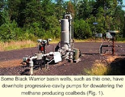
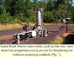
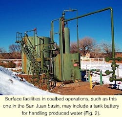
Figs. 1 and 2 illustrate surface equipment found in some coalbed operations.
Base line studies
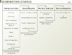
In view of the environmental controversy and negative popular perceptions that plague CBM development, base line studies are a relatively minor cost of doing business. Operators should consider including the right to perform base line testing of a lessor's water wells in their mineral lease. Such studies should then be carefully planned before and during lease acquisition and implemented before and during production. Table 1 lists components that can be included in a base line monitoring action plan. - Surface facilities in coalbed operations, such as this one in the San Juan basin, may include a tank battery for handling produced water (Fig. 2).
At the very least, simple work should be performed that includes testing a lessor's water wells, noting mechanical problems, determining water yield, detecting the presence of methane before production, and noting anecdotal evidence of methane discharges at the surface.
At best, a more detailed sampling and analysis of groundwater chemistry will help operators understand environmental conditions before production.
Armed with these studies, operators can better quantify the risks associated with production activities and prioritize the development of acreage positions.
Delaying production in environmentally sensitive areas can provide ample time for establishing monitoring sites that can provide early warning signs of impending problems.
Remediation costs will be minimized when a program is in place to detect early warning signs and when contingency actions have been planned in advance. Operators who are sensitive to changes in the environment surrounding their producing fields are also in the best position to ward off needless litigation.
Local and regional base line analysis of aquifer properties should be conducted in two stages: a sampling and analysis program followed by a monitoring program.
During initial sampling, a minimum amount of data should be collected to help operators define early warning signs of impending problems relevant to the following most common complaints attributed to CBM production:
- Domestic water well quantity or yield.
- Domestic water well quality.
- Occurrence of free or dissolved methane.
Subsequent monitoring should be conducted in sensitive areas to determine if there are statistically meaningful trends in the value of environmentally sensitive parameters that may correlate with CBM activities.
A cost-effective sampling program limits the scope of investigation by identifying three areas of greatest concern:
- Where the risk of affecting local residents is greatest.
- Where water well problems unrelated to CBM production operations already are known to exist.
- Where either the risks of affecting production revenues or the opportunities for maximizing revenues are greatest.
Sampling should proceed with a randomized method for selecting sampling locations that are both within and outside of all three areas of interest. This approach minimizes possible bias and allows objective comparison of geographic and time-varying trends through the use of accepted statistical hypothesis-testing methods.
Sufficient samples should be collected to establish statistically meaningful threshold values of the environmental parameters that are most useful for warning operators of impending problems. These threshold values should be defined and used to establish action triggers.
Examples of actions to be taken might include additional sampling for more thorough analysis, or remediation. Threshold values can also be used to guide operators in establishing protocols to implement consistent drilling, completion, and production practices.
Establishing hierarchy
Advanced planning can minimize the costs for a base line sampling and analysis program. The planning should begin early in the leasing phase of a shallow gas prospect, and it should be designed by a multidisciplinary team, with members having different background training and responsibilities. For example, landmen, geologists, log analysts, reservoir engineers, and hydrologists.
Ideally, the team should be led by an individual who has good leadership skills and is comfortable working with multidisciplinary data. The team leader should be responsible for knowing where and how to retrieve base line information in the event of problems.
A cost-effective base line sampling program consists of a pyramidal hierarchy of tasks performed sequentially. Each task leads to a subsequent and more expensive analysis level that may be required to characterize critical environmental parameters satisfactorily.
Over the long-term, the advantage of a staged program is that additional costs only are incurred if necessary.
Reconnaissance
Compiling a variety of hydrologic, historic, and geologic data in a shallow gas basin is important and offers the greatest benefits at the lowest cost. These data can provide 80% of the information for assessing potential environmental impacts and the relative risk associated with shallow gas drilling and development.
This reconnaissance provides operators with:
- Historical context for evaluating water quality and quantity delivered by various aquifers.
- Historical context for known gas seeps.
- Historical context for areas that may be affected by other potentially hazardous anthropogenic activities.
- Regional framework for determining base line sampling areas.
- Regional framework for designating critical areas at risk that should be sampled or monitored.
This evaluation will define specific requirements for spatial and ongoing temporal water and soil sampling plans.
Most basins have multiple aquifers among shallow, intermediate, and deep stratigraphic intervals. Their yield and water quality is usually highly variable, and in many instances most problem areas are well known and documented. Much can be gained from collecting and assimilating publications specializing in various aspects of local and regional hydrology that are issued by municipal, state, and federal agencies.
In western states, a state engineer's ground water division will have permit records documenting the location, depth to completion, and water level data for many domestic and commercial water wells. These data need to be collected and assimilated into a data base and, when needed, plotted to find areas that are either sparsely or densely drilled and to identify the various aquifers utilized.
Changes in the rate of water well drilling also should be noted because uncontrolled population growth can diminish local aquifer yields. This is particularly true when domestic well water is increasingly used to irrigate lawns and gardens or to fill pools and ponds.
The best data come from site-specific inspections. For example, when landmen are in a house negotiating a lease, they should inquire as to the water quality and yield at that residence. With a little training, anyone can identify residential areas already experiencing water problems.
Nearly every location designated in lawsuits as having experienced problems with gas seeps due to CBM operations has been an area with historically active gas seeps. In most cases, these areas have outcrop belts where the producing formation is within 50 ft of surface. Many real estate developments were built in such areas before anyone recognized that building a foundation on or immediately above a coal seam is a geologic hazard.
This occurs in spite of local newspaper articles, many dating back to the mid to late 1800s, with reports of mining-related explosions, well house explosions, or even mysterious explosions in and around seep areas. Local ranchers usually know the history of gas seeps. Someone just needs to ask them.
In other instances, gas seeps have surfaced in areas where the production casing of conventional oil and gas wells lost integrity due to high shallow aquifer corrosion rates. Corrosive production field environments also affect pipelines, gathering lines, production facilities, and storage tanks. A breach in any of this infrastructure can charge shallow aquifers with hydrocarbons.
Hydrocarbons also can charge aquifers by either migrating from deeper horizons over geologic time, or being generated in situ by hydrocarbon-generating bacteria. More than 20% of the world's gas reserves has been generated by subsurface bacteria, and a large percentage of these are found in shallow reservoirs.1 Under the right conditions, landfills and leach fields can be prolific sources of bacterial methane.
Other sources of historic groundwater contamination, such as those due to blowouts, leaks from gasoline station tanks, or other sources can easily be discovered by reviewing archived well files. In this context, it is necessary to identify and plot all wells in an area that are producing from deeper horizons. Under the right circumstances, fluids from these horizons could contaminate the aquifer.
A review of drilling records and mudlogs also can reveal hydrocarbon sources that could affect aquifer quality. For example, wells often encounter shallow gas shows when drilled to deeper horizons. These gas shows, predating any drilling in the area, indicate that gas has migrated to shallow horizons over geologic time.
These records may also show no shallow gas. For instance, drilling logs from the San Juan basin show wells drilled in the Mesaverde or Dakota formations in the 1940s did not encounter any shallow hydrocarbons. But more recent drilling records from twin well locations drilled to the shallower Fruitland formation indicate the presence of shallow gas. This is evidence of casing failures caused by corrosion that allowed hydrocarbons to charge the shallow sands.
Abandoned surface and underground mines may provide another contamination source for aquifers.
Under the right conditions, the quality and composition of backfilled soils in surface mines can affect groundwater quantity and quality for many years after reclamation ceases. Underground mines can cause differential subsidence at the surface that cracks roads, driveways, and foundations. This fracturing can provide a path for gas to reach the surface.
It is important to collect relevant information that predates CBM development. For example, permitting data complying with the Surface Mining Control and Reclamation Act, the Bureau of Mines, the US Geological Service (USGS), and state departments of environmental quality are excellent sources for base line hydrologic and geologic data.
Wireline logs record porous and permeable fairways in shallow aquifers that underlie residential areas. These logs help differentiate aquifer horizons that are trapped by domestic water wells completed at different depths. Wherever possible, one should identify key marker beds and then plot their distribution on structure maps.
Shallow structural and stratigraphic traps could provide local reservoirs for shallow gas to accumulate.2 To identify these, if shallow wireline logs are not available, one can run gamma ray logs through casing whenever a CBM producing well needs repairs.
Maps and images can indicate the distribution of aquifers and possible natural gas seeps in a regional context. For example, geologic, soil, topographic, and vegetation maps should all be reviewed before designing a sampling program.
Remote sensing images and aerial photography provide valuable synoptic views of an area. For example, color infrared and color photography help identify evidence of current or historic coal burns. Spectral imagery can help identify areas where discharging aquifers (springs) may be transporting dissolved iron that oxidizes at the surface. These are logical places to test for methane and sulfide gas.
Climate data are of great value. Local airports and municipalities often keep accurate climate records for decades and the National Oceanic and Atmospheric Agency compiles data that are available on the internet.
Local and regional precipitation trends will establish the ideal timing required to collect seasonal samples. Local aquifers recharge during rainy seasons, when alluvial deposits are saturated and irrigation ditches are full. In semi-arid to arid environments, melting snow efficiently recharges local aquifers.
This variability will systematically influence analytical results because recharge will significantly affect aquifer water levels. One, therefore, needs to document this variability.
Sampling also should be conducted before soil freezes or after it thaws.
Sampling objectives
After one gathers the information in a reconnaissance study and has differentiated base line areas from critical areas at risk, then it is time to design an aquifer characterization program3-7 into three components:
- Documenting and implementing standardized sampling and analysis protocols.
- Making provisions for quality assurance and control practices in the field and among laboratories used to provide analyses.
- Designing rigorous statistical tests to evaluate multiple hypotheses.
Operators should be aware, however, that they will inevitably be accused of collecting biased information. Strict adherence to and documentation of objective sampling and analysis practices will help alleviate such concerns.
One should collect both spatial and temporal samples to characterize adequately any site. Spatial sampling defines, compares, and contrasts geographic patterns in data collected from local and regional aquifers. This sampling requires one to design a grid and use a grid spacing that is appropriate for capturing a minimum amount of information at a desired scale.
One can gather samples at random anywhere inside the grid, which is an example of random stratified sampling. The number of samples must be designated if one statistically analyzes the aquifer data. For example, a set of 24 samples is a reasonable estimate, within 20%, of the mean and variance for a single aquifer parameter.
Temporal (repeated) sampling helps establish how the range of values for any given aquifer parameter varies at any location due to changing environmental conditions. One should defer the design specifications for collecting temporal samples until completing spatial surveys.
Spatial and temporal sampling programs can be used to design an aquifer monitoring program. Temporal sampling of producing CBM aquifers also provides a powerful means to assess reservoir continuity and to assess drainage patterns.
A sampling program should quantify parameters that are useful for characterizing the quality of various aquifers identified in the reconnaissance program. A sampling hierarchy should be used to minimize the costs needed fully to quantify environmentally relevant properties of soils and aquifers.
Three cost-based levels to a sampling hierarchy are: field sampling and analysis methods, standard laboratory analyses, and special laboratory analyses.
Field methods
Field sampling methods are screening tools and offer the most cost-effective means to establish the potability, oxidation state, and general chemical properties of water in aquifers over a large area. Only a few hand-held field instruments need to be calibrated daily for these analyses. These instruments measure acidity (pH), redox potential (Eh), temperature, conductivity (used to determine the relative concentration of dissolved chemicals), and dissolved oxygen (dO).
Other useful data pertain to observations made with one's senses such as water color, clarity, and smell. It is relatively easy and inexpensive to collect hundreds of field samples in a single season among a variety of sites that include springs, water wells, CBM production wells, streams, surface reservoirs, irrigation ditches, and other sources of aquifer recharge. This prolific source of information can then be used to selectively target a smaller suite of samples slated for more expensive laboratory analyses.
Sampling ambient air above various soil and outcrop horizons also provides a good means for screening sites where soil gas probes should be installed. Such sampling is usually performed along specified transects where gas seeps have been informally documented or can logically be suspected to occur. These types of analyses are best conducted in areas both far from and within critical areas of potential risk. Outcrops, producing wells, and production facilities are common risk targets.
A variety of hand-held sniffer detectors can analyze ambient air quality. One also can analyze headspace gases of soil samples, gases liberated from water samples collected in springs and streams, or gases liberated when domestic well water is used to fill sinks or buckets.
Of the available organic vapor analyzers (OVA), flame ionization devices (FID) offer the greatest sensitivity to low hydrocarbon concentrations. Many companies offering such services provide trained observers who can detect the surface manifestation of gas seeps. Alternatively, company personnel can be trained quickly to use rental equipment for such activities.
Walking the ground should be considered an important component of field analysis methods. Public education forums can help persuade residents to cooperate with an operator's efforts to randomly conduct sniffer surveys of residential basements and crawl spaces. One should always encourage educating a concerned public before production activities. Any excuse for two-way communication provides valuable clues regarding water quality issues already facing a community.
It is usually difficult to measure static water levels in domestic water wells. Obtaining permission to access properties is a significant problem in western states. Even if access is granted, many operators are leery of disassembling well heads for fear that they may be accused of damaging the well. Some operators may opt to drill and maintain monitoring wells at even higher costs.
At the very least, operators should randomly inspect a specified number of domestic well heads. A surprisingly large number of wells are poorly constructed, lack sanitary seals, or have other obvious problems that can account for poor water quality and quantity.
Numerous plaintiffs who have complained of declining water yields and water quality were unaware that their do-it-yourself maintenance practices allowed them to inoculate their wells with bacteria. As a result, rich bacterial cultures growing in their wells were so prolific that thick slime coated the aquifer, thereby restricting aquifer yield.
Laboratory analyses
Once an area has been screened with data from field analyses, there are more detailed and expensive analyses which can be conducted on a relatively small number of targeted samples.
Targeting strategies are most effective when based on statistical analysis of field data. Results of such analyses can be used to unambiguously differentiate among aquifers. Each aquifer can then be selectively sampled and analyzed for a variety of specified inorganic and organic constituents.
Wet chemical analyses are standard and relatively inexpensive. A typical suite of analytes includes the major ions as follows: calcium, magnesium, potassium, and sodium (positively charged ions) and carbonate, bicarbonate, sulfate, and chloride (negatively charged ions). Checking the charge balance between positively and negatively charged major ions is one good way to check quality control.
Other analytes that are typically measured are iron and manganese, dissolved nitrogen compounds, and non-reactive ions such as bromine and fluorine. Some operators also measure the concentration of selected metals listed by the Resource Conservation and Recovery Act as potentially hazardous. It is also customary to measure other properties of water in the laboratory, such as pH, and conductivity.
In the search for potential sources of hydrocarbon contamination, samples should be analyzed for the total concentration of dissolved organic carbon components. Benzene, toluene, ethyl benzene, and xylene (BTEX) analyses should be performed routinely as they are the best indicators of migrated petroleum or leaking sources of distillate and gasoline.
Special samples are needed to determine the concentration of dissolved methane in water. Analysis of dissolved gas concentrations is particularly important because naturally-occurring bacterial methane is a common and ubiquitous constituent of basin margin aquifers.
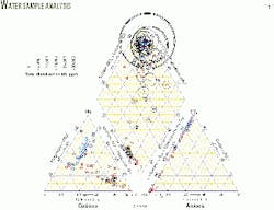
Fig. 3 shows a trilinear, Piper diagram, from water samples north of Gillette, Wyo., in the Powder River Basin. Blue dots are surface and alluvial water samples, red circles are overburden water well samples, black circles are coalbed produced waters, and purple squares are deep Fort Union aquifers. This diagram illustrates the distinctly recognizable hydrochemical facies of different aquifers in the area.
Special laboratory analyses
If gaseous hydrocarbons are found to be dissolved in water samples or discovered to be emerging along seeps, it is important to characterize them. Chromatography and isotopic analyses are the best means available to assess the likely source of gas contaminants. These measurements require special laboratory analyses which are reliably performed by only a handful of laboratories in the US and elsewhere.
Stable isotopic analyses of carbon, hydrogen, and oxygen are the most expensive environmental measurements generally made in CBM production-related base line studies. In some areas, the stable carbon isotopic content of methane is sufficient to distinguish between methane of thermogenic and bacteriogenic origin.
In many instances, however, the stable isotopic compositions of carbon and hydrogen in methane, carbon in associated carbon dioxide, and the hydrogen and oxygen of associated water samples are all needed to differentiate adequately among potential gas sources.8
The stable isotopic composition of gas samples collected near or at the surface should be compared with stable isotopic analyses of methane collected from a select number of producing wells tapping all producing horizons.
References
- Gorody, A.W., "The origin of shallow gas in groundwater overlying the Ignacio-Blanco gas field, San Juan Basin, near Bayfield, La Plata County, Colorado," Wyoming Geological Association, 52nd Annual Conference Guidebook, In press, 2001.
- Wiese, K., and Kvenvolden, K.A., "Introduction to microbial and thermal methane," In: The Future of Energy Gases, USGS Prof. Paper 1570, 1994, pp. 13-20.
- Koterba, M.T., Wilde, F.D., and Lapham, W.W., "Ground-water data-collection protocols and procedures for the national water-quality assessment program: collection and documentation of water-quality samples and related data," USGS Open File Report 95-399, 1995.
- Mueller, D.K., Martin, J.D., and Lopes, T.J., "Quality-control design for surface water sampling in the National Water-Quality Assessment program," USGS Open File Report 97-223, 1997.
- Shelton, L.R., "Field guide for collecting and processing stream-water samples for the National Water-Quality Assessment program," USGS Open File Report 94-455, 1994.
- Ott, W., Environmental Statistics and Data Analysis, Lewis Pub., 1995.
- Cothern, R.C., Handbook For Environmental Risk Decision Making: Values, Perceptions, and Ethics, Lewis, Pub., 1996.
- Clark, I.D., and Fritz, P., Environmental Isotopes In Hydrogeology, Lewis Pub., 1997.
