E. INDONESIAN GAS-2 - Potential giant gas reserves await development in Irian Jaya
This is the second of two parts on undeveloped gas reserves in the Waropen basin of northern Irian Jaya on the island of New Guinea. The reserves described here are proven by gas discoveries made in 1958 and 1973, both of which were abandoned for lack of oil indications.
Background information on the tectonics and stratigraphy of the Waropen basin, plus discussion of the earlier, onshore discovery well (the Niengo-1), were presented in the first article (OGJ, June 18, 2001, p. 34). Here we provide information on the second discovery area, centered on the offshore R-1 well, which also found gas in turbiditic sands of the Mamberamo D unit (Plio-Pleistocene).
Drilling history
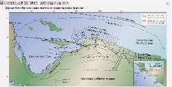
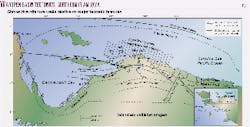
During 1973, Tesoro Petroleum Corp. in partnership with Pertamina, the Indonesian national oil company, conducted a five-well venture off Irian Jaya's northern coast. These wells included the E-1, H-1, O-1, P-1 (Fig. 1). The last of these was a significant gas discovery, testing 21.6 MMcfd of gas and 5 b/d of oil.
The five wells were drilled in 179 ft (P-1) to 501 ft (H-1) of water. R-1 and O-1 were drilled on an irregular basement rise here called the Niengo platform. P-1 is located along the Yapen fault zone, a major transpressional structure, while E-1 and H-1 tested structures to the south along the Waipoga fault (Fig. 1). All five targeted domal structures mapped on the basis of a coarse grid of seismic data. Prospective features were oriented northeast-southwest and ranged from 8-10 km in length and 5-9 km in width. Mapped vertical closure varied from 150-600 m (close to 500-2,000 ft). Normal faulting, oriented parallel-subparallel to fold axes, was also observed.
Sidewall cores were recovered from every well. These cores were analyzed for hydrocarbon shows, porosity, permeability (vertical and horizontal), water saturation, and oil saturation. Geochemical analysis to determine source rock quality was also performed on several of the wells.
Well results
Of the five wells drilled, three had significant hydrocarbon shows (H-1, P-1, R-1) and one (R-1) was a gas discovery. Penetrated section in all wells mainly consisted of Mamberamo formation clastics, particularly the C and D units of Plio-Pleistocene age. Black asphaltic residue was noted in the basal portion of the H-1 and P-1 wells.
In both E-1 and H-1, the Mamberamo section was thicker than expected (>7,500 ft) and highly argillaceous in character. These two wells are located in the southwestern portion of the basin, specifically in a graben-like trough associated with the Waropen fault, a major wrench structure. It is suggested that this infrabasinal depocenter was a deeper, quieter marine environment during the late Tertiary.
Significantly more sand was observed in the P-1, O-1, and R-1 wells. This sand consisted of very fine-to-fine grained, poor to moderately sorted, friable and argillaceous material, with 50% or less quartz. Feldspar and lithic fragments (frequently volcanic) are fairly abundant and have not been diagenetically altered, presumably due to the short period of burial. These sands are poorly consolidated and can exhibit considerable primary intergranular porosity.
Interestingly, log and core analyses performed on these sands yielded different results. Logs tended to show a considerable decrease in porosity with depth, and log analysis suggested 90-100% water saturation in almost every sand. Resistivities were observed to be very low, e.g. 0.3 to 0.075 ohms. Yet core analyses (sidewall samples) indicated little or no loss of reservoir quality with depth: in P-1 and R-1, for example, porosities of 15-26% were observed in sands throughout the entire Mamberamo section, while water saturations varied from 50% to 85%. Highest porosities were seen in O-1, which reached total depth (TD) at only 4,630 ft in oceanic basement, and which indicated 30-40% porosity in unconsolidated sands down to the base of the Mamberamo C (3,800 ft). Permeabilities in the Mamberamo sands are quite variable, ranging from 1 md to 368 md, but most often range 1-10 md.
On the basis of available data, these sands are interpreted to be potential low-resistivity reservoirs. The presence of significant bound water in the clays of these argillaceous sands appear to influence the very low resistivities observed.
Seismic structure
The R-1 well was drilled to 2,293 m (7,568 ft) on an anticline 5 miles (8 km) wide and 8 miles (13 km) long. Vertical closure for this structure was estimated from seismic data to be on the order of 1,100 ft (330 m).
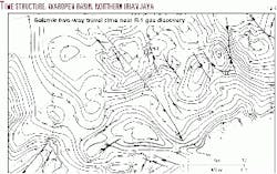
On a preliminary time-structure map for the area immediately surrounding the R-1 location (Fig. 2), contours represent the interpreted top of basement and indicate a highly irregular surface with relief perhaps of 2,000 ft or more. Well data suggest this is a Pliocene erosional surface, with some local accentuation due to faulting.
Fig. 2 shows a number of inselberg-like highs forming a general SW-NE trend that extends for over 30 km. To date, R-1 is the only well to test this trend.
R-1 discovery well data
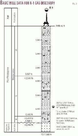
The main objectives of this well were to test sandstones of the Makats formation and carbonates of the Auwewa formation. The Makats was not present (Fig. 3), while the Auwewa proved to consist of subordinate marly limestone overlying basic extrusives and intusives and possibly faulted continental (metamorphic) basement.
Lithology in this well mainly consisted of claystone with siltstone and sandstone interbeds and occasional carbonized plant material (Fig. 3). This material is interpreted to comprise the Mamberamo formation, specifically the D and C units, with a small subsidiary portion of B unit at the base. The B unit was observed to overlie Auwewa carbonate interslivered with basalt, andesite, and peridotite. Deeply weathered in situ clays were also present, suggesting the contact between this interval and the B unit represents an erosional unconformity.
A strong gas kick occurred at 5,767 ft, measuring 700 units of methane against a background of 30 units. Sidewall core samples from this depth indicated very fine to fine grained, poorly sorted, friable, argillaceous, and calcareous sandstones, with some cleaner layers (quartz >50%) interbedded with siltstone and clay laminations.
Porosities in these sands were 22-28%, with permeabilities up to 10 md. Log analysis suggested the sandstone zone was gas-charged. A drillstem test performed at 5,767-5,773 ft on a 1/4-in. choke yielded a rate of 21.6 MMcfd of gas with 5 b/d of 47° gravity oil. Calculated absolute open flow potential for this one zone was just over 100 MMcfd.
Sands of similar character were observed to the base of the Mamberamo formation. Core porosities are high in these sands, at 21-27%, with permeabilities of 6-28 md. Limestone encountered below these rocks is friable, cryptocrystalline, occasionally chalky or argillaceous, with porosities of 27-31%. Spotty fluorescence was observed at several depths in these rocks.
The productive interval tested in the R-1 well is only 8 ft in thickness. Nonetheless, total size of the reservoir could be quite large if the entire structure (70 sq miles-180 sq km) proved to be productive. In addition, structure maps of the immediate surrounding area indicate a number of other features of similar size and closure. These structures appear to exhibit both fold- and fault-related traps. It is also possible that additional sands exist in other locations on the R-1 feature and the other structures shown. Predicting these would seem to require knowledge of sand provenance and relevant depositional trends.
Waropen potential
The R-1 well, like the onshore Niengo-1, represents a significant, undeveloped gas discovery of considerable potential. These wells were drilled decades ago, prior to the advent of many of the modern seismic and well log analytical tools now available.
Recent re-evaluations based on some of these tools confirm the large, possibly giant gas potential of the area. The Waropen basin remains a frontier area of established hydrocarbon presence, in which commercial rates of production appear probable. Development of these reserves is the future responsibility of companies interested in the region.
The authors
Scott L. Montgomery is a Seattle petroleum consultant and author. He is lead author of the "E&P Notes" series in the AAPG Bulletin. He holds a BA degree in English from Knox College and an MS degree in geological sciences from Cornell University. E-mail: [email protected]
Richard L. McAdoo is a geologist and president of Continental Energy Corp., which is involved in exploration and development activity on three Indonesian blocks, including the Yapen Block off Irian Jaya. After 7 years working in the North Sea and Europe, he has lived in Jakarta 17 years. He holds BS and MS degrees in geology from Texas Tech University and an MSBA from Boston University.
James C. Haebig is a geophysicist and vice-president of Continental Energy Corp. He has lived and worked overseas since 1958, with projects in North Africa and South America prior to 1986, when he moved to Jakarta. He specializes in seismic interpretation and is particularly experienced in complexly faulted terranes. He holds a BS degree in geology from the University of Wisconsin.
Tom Fraser is a chartered geologist from Edinburgh, Scotland, who has worked internationally for 25 years. He is assigned to INPEX Masela, Jakarta, for appraisal of its recent Abadi-1 gas-condensate discovery. His interests include petroleum systems and stratigraphy in Southeast Asia and the North Australian margin.
Jack Wold is president and cofounder of Ramu International LLC and Wold Oil & Gas Co. and vice-president of Wold Oil Properties Inc. Before joining the Wold Cos. in 1983 he was a senior geologist with Amoco Production Co. and exploration geologist with BWAB Inc., Denver. He holds a bachelor's degree in geology from Colorado College and an MS degree in geology-geophysics from Cornell University.


