E. INDONESIAN GAS-1: Irian Jaya's Waropen basin could hold more giant gas reserves
Natural gas is fast becoming a primary energy source throughout the world. Its varied use, from power generation to commercial and residential heating, has grown by more than 40% globally the past decade alone and shows signs of accelerating.
At the same time that demand has grown, actual production in many regions has fallen largely due to lack of exploration and replacement of consumed reserves. This is particularly true in the US, for example, where production has declined 17% the past ten years while consumption has increased 45%.
Such facts bring to the fore several important points. The combination of growing demand and insecure (even shrinking) supply leads sooner or later to the type of shortages and related "crises" seen this past winter in North America. Many analysts now view higher gas prices as the probable norm in months and years ahead. Thus, companies able to command large new reserves-especially on the international scene-will be in excellent position to profit at a high level from these trends.
It is with this in mind that the following two-part article suggests the type of exploration opportunity that exists internationally, particularly Southeast Asia. This is the primary area of the world where large new reserves have been found in recent years.
Within the past decade, no fewer than six giant gas fields (>5 tcf) have been discovered in Southeast Asia, half the number for the entire globe, with two of the new giants on New Guinea island alone.
Such discoveries have come about because systematic exploration, particularly for gas, is very recent in this region, particularly on New Guinea, both on the eastern half of the island, occupied by the country of Papua New Guinea, and on the western half encompassed by Irian Jaya Province, Indonesia.
The articles presented here and next week describe yet other undeveloped discoveries in a prospective area along the northern coast of the island, which may well hold a third giant accumulation.
Tectonic setting
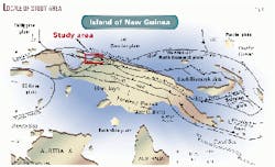
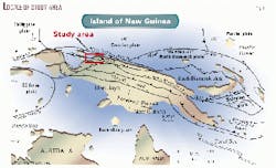
The area of interest lies along Irian Jaya's northern coast (Fig. 1). This is a tectonically active region that includes a series of late Miocene to Quaternary successor basins developed from a Neogene forearc province subjected to collision-related compression, wrench faulting, uplift, and related sedimentation.
The specific setting is the Waropen basin, a 60,000 sq km area that includes several local depocenters within an overall basinal province. This province is just east of the Salawati and Bintuni basins, where huge reserves of oil and gas (>500 million bbl of oil and 18 tcf of gas) have been found recently.
Plate tectonic history in this region is very complex and incompletely resolved. In general, northern New Guinea records late Mesozoic extension and passive margin development, followed by the onset of subduction in the early-mid Tertiary and oblique convergent-collision between the Indo-Australian and Pacific plates in late Tertiary time.1 2
To the north and west, the Waropen basin is bounded by shallow oceanic basement, to the south and east by exposed metamorphic rocks. Up to 10 km of sediments, mainly Plio-Pleistocene turbiditic clastics with thick localized reefal carbonates, fill the basin and testify to extremely rapid rates of subsidence and deposition, mainly via gravity flow processes.2 Current tectonic features include the active, left-lateral Yapen-Sorrong transform fault zone, which cuts east-west across the northern portion of the Waropen basin province.
Stratigraphy
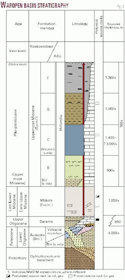
Existing stratigraphy in the Waropen basin (Fig. 2) is based on combined outcrop study and data from 12 wells existing in the province, including the Niengo-1 gas discovery.
The oldest sediments include Paleocene-Oligocene limestone and intercalated volcanics of the Auwewa formation. These rocks are deformed along with oceanic basement and thus predate the major episode of collision and basin filling. Post-collision deposits begin with the overlying Darante formation (Late Oligocene-Miocene), including reefal, shoal, and pelagic carbonates interbedded with shales and minor volcanics.
Aggressive clastic input began with uplift of basin margins in the early to mid-Miocene and continued through the Plio-Pleistocene. This led first to deposition of thick conglomerate, graywacke, siltstone, and shale of the Makats formation in a succession of submarine channels and prograding fan systems.
Overlying this material is the Mamberamo formation, a thick regressive sequence (2-5 km) of turbidite, basinal shale, and deltaic deposits with shallow marine carbonate rimming the basin margins and covering interior highs. The Mamberamo includes four members (B-E; see Fig. 2) that record transgressive-regressive phases within the principal episode of basin filling.
The Mamberamo B and C members document, respectively, a distal turbidite sequence succeeded by progradational submarine fan deposits (conglomerate, sandstone, siltstone, shale) and finally, in the upper C member, by lignite-bearing deltaic sediments that essentially filled much of the basin to near sea level. This basic progression was largely repeated during deposition of the D and E members.
In the deeper portions of the Waropen basin, however, immediately north of the Yapen fault zone, bathyal conditions prevailed through much of the Plio-Pleistocene due to fault-related subsidence, resulting in a thick pile of alternating turbiditic sands, silts, and shales. The E member, like the upper C member, consists largely of fluvial-deltaic clastics and lignite. It is overlain by unconsolidated alluvial deposits of the Koekoendoeri formation.
Structure
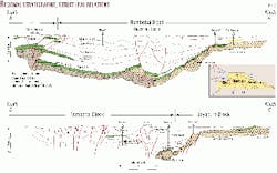
The basin is divisible into north and south portions separated by the Yapen fault zone (Fig. 3). The northern portion is floored by ocean crust with significant extensional faulting and anticline development above fault-related basement highs. Mamberamo formation deposits thin appreciably northward, with members B and C pinching out along the middle to upper flanks of the bounding basement arch.
The Yapen fault zone is a major trend of strike-slip deformation affecting the entire stratigraphic section and underlying basement. Juxtaposition of mixed continental-oceanic crust to the south against oceanic crust to the north takes place along this zone of transform motion.
Available seismic data indicate the presence of complex, flower-type structures extending to depth. Surface expression includes a line of mud volcanoes that follows the fault trace for up to 90 km. Regional relationships suggest that the Yapen was initiated in Pliocene time as a result of oblique collision.1 2 3
South of the Yapen, the basin shallows and exhibits reduced faulting, compared with the northern portion. Large anticlines in this area are interpreted to be a result of shale diapirism related to overpressure. The southern margin is marked by basement-involved thrusting of Plio-Pleistocene age, which affects units as young as Mamberamo E.
Petroleum geology
The Waropen basin contains all the elements of a major petroleum system.
In addition to high quality reservoir and source rocks, abundant traps, sufficient maturation levels, and migration pathways, the basin is the site of a variety of oil and gas seeps.
Reservoir rocks fall into three main categories:
- Fluvial-deltaic sands of the Mamberamo D and E members.
- Turbidite sands of the Makats formation and Mamberamo B and C members.
- Reefal carbonates of Miocene-Pleistocene age, on basement highs and in basin flank positions. Of these types, the first has been found productive in the Niengo-1 discovery. This well will be discussed below.
Seals include shale intervals observed in the Makats and Mamberamo formations. Traps include both structural and stratigraphic types, including large anticlines and fault-related closures in the northern basin, mapped on the basis of existing seismic data, and lateral pinchout and facies changes within the thick turbidite section of the Makats-Mamberamo.
Geochemical data derived from five wells in the area as well as from surface samples indicate the dominant presence of herbaceous and herbaceous-coaly kerogen, with secondary woody-coaly and minor amorphous kerogen. Total organic carbon (TOC) values for shales of the Makats and Mamberamo C member range from 1-3%. Lopatin maturity calculations for the Makats suggest an onset of gas generation at about 6,000 m. Maximum depth of the Makats is near 10,000 m in the northern basin and 7,000-8,000 m in the south.
Overpressure exists in much of the basin starting at depths of 1,600 m or less. This is interpreted to be a result of retarded shale dewatering related to very rapid rates of deposition in Plio-Pleistocene time during the principal episode of basin filling. Wells in both the northern and southern parts of the basin indicate that the degree of overpressure increases with increasing shale thickness and that the transition from normally pressured to overpressured intervals is fairly abrupt.
Gas discovery
Exploration in the Waropen basin began during the 1950s with surface mapping, gravity surveys, and the drilling of several wells by Royal Dutch/Shell.
At that point, all interest was focused on the province's oil potential. The Gesa-1 and Gesa-2 wells south of the Yapen fault zone along a major anticline encountered strong gas flows at around 1,590 m and were abandoned in the Mamberamo D.
In 1958, the company drilled a third well, Niengo-1, this time north of the fault zone. Niengo was located on another large anticline and experienced repeated gas influx at high pressure below 1,500 m, eventually testing 4.5 MMcfd, 99% methane, from a 7-m sand in Mamberamo D at 1,500-23 m. The well was abandoned and remains an unexploited discovery.
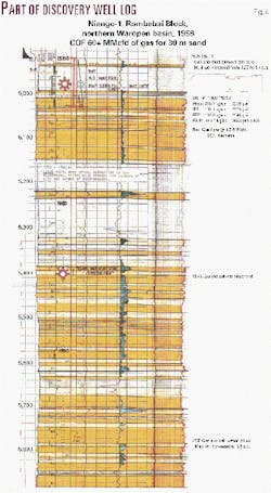
The report on this well shows that gas influx occurred from Mamberamo D sands to a depth of 1,840 m, where a "gas-salt water contact" was determined on the basis of drillstem testing. A total of 100 m of net gas pay sand was logged in this well. Calculated open flow rate for the 7-m tested interval exceeded 60 MMcfd.
As shown on part of the log for this well (Fig. 4), the gross pay interval consists of numerous individual sands, 2-10 m thick, interbedded with silty claystone layers. The tested reservoir interval is estimated to have porosities averaging 25% and permeabilities above 100 md. Total depth was reached at 2,037 m, 200 m below the base of the reservoir section, where oceanic basement ("greenschist") was encountered.
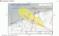
The structure map (Fig. 5) shows that the Niengo-1 discovery is located along the southeastern portion of a major anticline with several hundred meters of closure. Within the area of closure, the structure measures 7 x 27 km (189 sq km) in size. To date, Niengo-1 is the only well drilled on the structure.
Seismic data
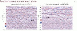
Existing 2D seismic data acquired by Ramu Exploration, which holds a large lease block centered on the Niengo discovery, has been reprocessed recently.
Two of these reprocessed lines, showing data across the Niengo structure and including the discovery well, indicate that the structure is draped on a prominent basement high (Fig. 6). The data further suggest several important conclusions:
- At least 100 m of elevation at the reservoir level is gained to the northwest of the Niengo well.
- Pinchout along the flanks of the basement high is evident within the Mamberamo and underlying Makats section, thereby suggesting stratigraphic as well as structural entrapment.
- The Niengo structure lies immediately updip from a shale-rich basinal area to the south, which appears deep enough to have acted as an important "kitchen" for hydrocarbon generation.
The opportunity
Niengo-1 represents an unexploited opportunity in one of the world's most rapidly growing areas of gas exploration and discovery.
Geological, geophysical, and geochemical data available on this well and on the surrounding Waropen basin suggest that very large reserves have been generated in this area and are trapped mainly in submarine and deltaic sandstones of Miocene-Pleistocene age. Early exploration in the Waropen basin, bent on finding new oil reserves, was unprepared to develop even a relatively shallow gas find.
The pattern of searching for and uncovering older discoveries of gas made in the days when oil was pre-eminent has come to define an essential aspect to contemporary exploration. Past revelations of future potential present an opportunity ripe for "discovery" today.
Acknowledgment
The authors thank Pertamina and Ramu International LLC for providing data used in preparing this article.
References
- Hall, R., "The plate tectonics of Cenozoic SE Asia and the distribution of land and sea," in Hall, R., and Holloway, J.D., eds., "Biogeography and geological evolution of SE Asia," Backhuys Publishers, Leiden, Netherlands, 1998, pp. 99-131.
- McAdoo, R., and Haebig, T., "Tectonic elements of the North Irian basin," in proceedings, Indonesian Petroleum Association 27th annual convention, pp. 1-15.
- Carman, G.J., and Carman, Z., eds., "Petroleum exploration and development in Papua New Guinea," proceedings of the Second Papua New Guinea Petroleum Convention, Port Moresby, May 31-June 2, 1993.
The authors
Scott L. Montgomery is a Seattle petroleum consultant and author. He is lead author of the "E&P Notes" series in the AAPG Bulletin. He holds a BA degree in English from Knox College and an MS degree in geological sciences from Cornell University. E-mail: [email protected]
Jack Wold is president and cofounder of Ramu International LLC and Wold Oil & Gas Co. and vice-president of Wold Oil Properties Inc. Before joining the Wold Cos. in 1983, he was a senior geologist with Amoco Production Co. and exploration geologist with BWAB Inc., Denver. He holds a bachelor's degree in geology from Colorado College and an MS degree in geology-geophysics from Cornell University.
