New Views of the Subsurface Play concepts of oil exploration in Yemen
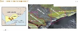
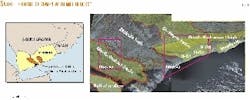
MOL Hungarian Oil Co. has conducted exploration in Yemen since 1996 and operated in two blocks: North Mukalla Block 48 and SE Al Maber Block 49 (Fig. 1).
As a result of our technical work, a tectono-stratigraphic model has been developed, new geochemical investigations on source rocks have been conducted, and a revised play concept has been proposed for the Marib-Shabwa and Sir-Sayun basins in Yemen.
This article summarizes our work, which may be used as a basis for future exploration in the region.
Two basinal settings and two basement highs constitute the structural framework of Yemen (Fig. 1). The Marib-Shabwa basin and the Sir-Sayun basin are extensional systems formed in the Upper Jurassic.1 These basins are separated by the Mukalla high, which was a highland for most of its geological life.
The South Hadramaut high is different in origin; it is a Tertiary feature formed as a mechanical response to the sea floor spreading in the Gulf of Aden. This high elevated within the Sir-Sayun basinal setting in a perpendicular direction to the Mukalla high.
The Tertiary tectonics was complex, producing transpressional features in some places, whereas transtensional structures formed in other areas.2 The Balhaf graben and some other minor grabens are the extensional results of the Tertiary reorganizations.
Tectonostratigraphic history
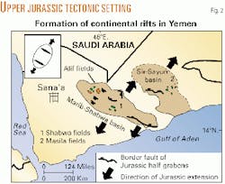
The geological history started in the Upper Jurassic, when tensional stresses split the Arabian peninsula from Gondwana and formed continental rift basins. The direction of the major extensional field was northeast-southwest oriented. A series of half-grabens formed in the Marib-Shabwa setting with changing polarities along the rift axis (Fig. 2).
Prior to the main rift activity, continental, fluviatile sediments were deposited (Kohlan formation) as basal, red bed-type sediments in the depressions. Later, the sea transgressed the region in the late Middle Jurassic, and the marine Shuqra carbonate formation was deposited.
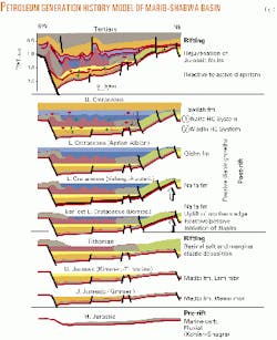
The main extensional subsidence occurred in Kimmeridgien-Tithonian time when the syn-rift Madbi formation deposited in normal fault controlled half-grabens (Fig. 3). The terminology of Beydoun3 is used here; he proposed a single formation name, Madbi, for the whole section between the Shuqra and the Sabatayn salt.
The lower member of the Madbi formation (Meem member) is composed of mainly shaly sediments and turbidites in the interior of the basins. Carbonates accumulated in the middle section of the Madbi in Block 49; Beydoun3 calls this the Ma'abir member. The upper part of the Madbi, the Lam member, is mostly shaly.
If no carbonate member is present, the Madbi formation is divided into Meem and Lam members in this article. A pronounced disconformity has been recognized on seismic sections and well logs within the Madbi formation. This surface corresponds with the top of the carbonate member.
Toward the end of the rifting, basaltic volcanic activity occurred in the time of Sabatayn and partly Naifa deposition. The Marib-Shabwa basin isolated from the sea by the Tithonian period and an evaporating basin formed. Thick salt deposits precipitated (Sabatayn formation) that later played a crucial role in the formation of hydrocarbon systems. The Sir-Sayun basin remained open to the sea, and no evaporitic sedimentation took place.
The main rift activity ceased after the Tithonian, and most of the area underwent a regional subsidence during the Cretaceous post-rift phase. First, the Naifa formation was deposited, which represents a transition from the saline conditions to open marine carbonate factory.
The Naifa limestone series is relatively thin in the Marib-Shabwa basin, but it has considerable thickness, called the Naifa-Saar formations, east of the Mukalla high in the Sir-Sayun basin.
The overlying Qishn formation was produced by eustatic changes in the Aptian-Albian. Its lower member is usually a clastic fluviatile unit, which is covered by the upper carbonate member. The trend in thickness variation corresponds with that of the underlying Naifa-Saar formations in that it becomes thicker toward the east.
While mainly a two-fold unit in the Marib-Shabwa basin, the Qishn is composed of several sedimentary cycles in the Sir-Sayun basin. Putnam, et al.,4 who studied the facies of the sandstone, distinguished a lower fluviatile, a middle estuarine, and an upper subtidal unit.
The Upper Cretaceous was an overall regressive cycle (Tawila Group) with some marine transgressions that reached primarily the area east of the Mukalla high.
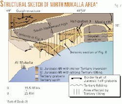
The Paleogene brought about a major tectonic reorganization (Fig. 4) that was related to the opening of the Gulf of Aden. Former Jurassic faults rejuvenated, and eventually new grabens formed. The opening of the Balhaf graben and a smaller graben in the vicinity of Mukalla occurred at this time.
The orientation of these features shows that the extensional field slightly rotated counter-clockwise. The Mukalla high seems to be a major division of different tectonic regimes. Primarily extensional tectonic features formed west of the Mukalla high, while the Sir-Sayun area was affected by a major inversion.
Fig. 5 shows a segment of the Marib-Shabwa basin in its southeastern portion (area of Block 49) as a typical example of its tectonic style. The faults formed originally in the Upper Jurassic and reactivated in the Paleogene.
The northern area of the block, a flat platform, acted kinematically as the hinge margin of a major half-graben. The border fault of the half-graben is located south of this block section. The interpreted section of Fig. 6 shows the major half-graben structure, which is the characteristic tectonic style of the Marib-Shabwa basin. The interior of the area is segmented by normal faults; the throw of the faults increases in opposite directions. Tectonic transfer zones or accommodation zones transfer the differential motion from one segment to another.
The section gives evidence of erosional truncations indicating a Lower Cretaceous uplift of the northern hinge margin that took place right after the deposition of the Naifa formation. The basin remained tectonically calm until Paleogene reactivation.
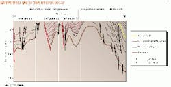
In the Sir-Sayun realm, three minor Jurassic rift grabens can be identified on seismic sections (Figs. 7 and 8) along the gulf. Each of these grabens became inverted during the Paleogene. Similar antiforms, including inverted normal faults, folds, and minor thrusts, dominate the structural style north of the South Hadramaut high.
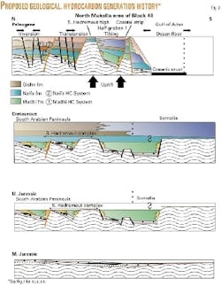
The South Hadramaut high uplifted by tectonic rebound to the opening gulf. Its southern flank tilted southward considerably, producing high angle tilted blocks. A narrow zone along the shore, called here the coastal strip, remained in an uplifted position relative to the tilted blocks (Fig. 9).
Salt dynamics
The salt was deposited in the Marib-Shabwa basin in the Tithonian time. Seismic data give evidence of an early mobilization of salt during the deposition of the Naifa and partly the Qishn formations. Thickening patterns and onlap configuration of the Naifa-Qishn section in salt withdrawal minibasins clearly indicate the timing and place of salt mobilization (Fig. 6).
The cause of this early salt movement was probably differential loading due to heterogeneously distributed sedimentation over the salt. Additionally, the uplift of the northern hinge margin and southward tilting of adjacent blocks (Fig. 6) together with the coeval basalt volcanism may well have contributed to the instability of the salt.
During the deposition of the Tawila Group, the diapirs probably grew passively until the onset of Paleogene tectonics. Fault reactivations produced strong reactive diapirism, and the Neogene uplift and erosion led to active diapir growth in some places.
Hydrocarbon systems
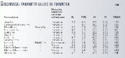
Table 1 summarizes the geochemical parameter values of the main formations measured in wells from both the Marib-Shabwa and Sir-Sayun basins.
These measurements give information about source rock characteristics, but because the wells are mostly placed on structural highs, the observed maturity levels may be lower than those existing in depressions where hydrocarbons were generated. The S2 values show that some immature parts of the Madbi formation have the best production potential; they are followed by the Sabatayn, Naifa, Harshiyat, and Shuqra formations (only immature samples were available).
The Hydrogen Index (HI) gives information about kerogen types especially, when the level of thermal maturation is low. The data indicate that only the Mukalla formation has gas-generating kerogen; all the other formations have oil-generating potential. The best oil-generating formation is the Naifa with HI values above 400.
It is noteworthy that some layers within the Sabatayn formation show high values of Production Index (PI) at a low level of thermal maturity. This suggests that the kerogen in this formation may be very decomposable. The Tmax values that are related to thermal maturity pass the critical 445° C. level only in places where volcanic intrusions caused excessive heating.
The depth of the 0.6% reflectance varies greatly in the area. The structures that underwent Tertiary uplift have the oil generation level at shallow depth, while the basinal areas affected by no or minor uplift have the oil onset at around 2,700 m.
According to our geochemical investigations, two main hydrocarbon sources developed in both basins (Figs. 3 and 9). One is the shaly members of the Madbi formation and the other source is the limestone Naifa formation. In the Marib-Shabwa basin, the intrasalt shaly layers are also excellent source rocks, although their potential for commercial oil generation is subordinate because of their limited volume.
Based on these facts, three hydrocarbon systems can be distinguished in the Marib-Shabwa basin: sub-salt Madbi; intra-salt Sabatayn; and supra-salt Naifa systems. Since no salt deposited in the Sir-Sayun basin, the petroleum system is based on two sources (Madbi and Naifa sources).
The salt is an impermeable material in general, consequently vertical migration across pure salt is physically impossible. However, because the salt underwent migration governed by pressure differences, its distribution has become heterogeneous. In places of salt withdrawal minibasins and faults, the salt weld may be a window for cross-salt migration.
Our geochemical data in Block 49 show evidence for vertical openness. Carbon isotope ratios and C2+ components of gas samples taken from the Qishn and post-salt formations were equivalent to maturation levels of the Madbi formation (below salt). Additionally, the thermal character of surface oil seep samples also indicates Madbi maturation level.
A volcanic activity that occurred around the end of rifting caused local thermal anomalies that impacted the maturation of organic material. Sample analysis in wells show local overmaturation and CO2 generation in association with magmatic dykes.
In the Marib-Shabwa basin, the subsalt Madbi system charged turbidite sandstones with hydrocarbons in the Madbi formation, their heteropic near-shore equivalents of fluvial and fan-delta facies, and the basal Kohlan-Shuqra series on elevated basement blocks. Intra-salt oil could be trapped in clastic layers interfingering with salt. The primary reservoir in the supra-salt system is the clastic member of the Qishn formation.
The Madbi and Naifa formations are the major sources in the Sir-Sayun basin as well. Geochemical parameters of the Masila fields give evidence of reservoir charge (at 1,600-1,800 m) from sources of different origin (Naifa and Madbi) but of high maturity levels (generated at least 2500 m depths), implying that the basin constitutes a largely open system for vertical migration. The primary reservoir in this basin is the Qishn formation that developed in great thickness in the whole area.
Basin analysis
The PetroMode 4.2 software package of Integrated Exploration Systems GmbH, Germany, (IES) was used for simulation of burial, thermal history, and hydrocarbon maturation and migration on an interpreted seismic section in Block 49.
Vitrinite reflectance, Rock Eval pyrolysis values, and bottom hole temperature data were used to calibrate the output results. Present day heat flow was settled to 46 mW/cu m, and three realistic heat flow history models were tested.
The first model employed the lowest possible heat flow values, while the other two trends had peaks in the Upper Jurassic and Eocene, respectively, according to our assumed tectonic model. In this way, possible minimum and maximum heating histories were applied in our quantitative modeling. The salt doming activity was settled to 58-50 Ma, which was the time of the main reactive diapirism. All the faults were assumed permeable both vertically and horizontally.
The modeling clarified the problem of Naifa maturation in the supra-salt play. Using even the highest heat flow model, the Naifa remained immature-early mature along the model section (Fig. 10). The Naifa in deeper portions of the basin may have entered the oil generation window when the earliest expulsion took place at 30-40 Ma. The intra-salt source generated oil earliest at 70 Ma.
The modeling confirmed that the Madbi formation is an effective source. Its earliest possible time to expel oil is 135-90 Ma using the high heat flow model (when using the low heat flow model, the oil expulsion time from the Madbi becomes about 85-50 Ma). The maturity depends on structural positions: The deepest parts of the block are at the end of the oil window or in the gas-generating phase.
The modeling showed that the main direction of migration is vertical upward. Conduits for migration are permeable lithologies, tectonic faults, and salt tectonic features. Significant accumulations are predicted in sandstones below the salt and in salt pinchout zones.
Potential of future exploration
The Madbi formation contains large amounts of mature source rocks that probably generated oil in the basin. The salt is a perfect seal (in locations where it exists); consequently, the primary targets of exploration in this basin must be subsalt reservoirs. In places where salt does not exist due to salt evacuation, the exploration of supra-salt reservoirs has also significance provided an efficient seal is available.
Since the basin is a continental rift setting, application of rift facies models in searching for reservoirs is essential. We found that rift structural features have a deterministic role in facies distribution. Faulted margins are associated with fans, while ramp margins can be favorable places of fluvial sediment influx.
An accommodation zone in the vicinity of a ramp margin is an excellent place for hydrocarbon accumulation because the accommodation zone forms basement highs, and fluvial sediment influx through the ramp carries sandstones to the highs (Fig. 5).
The supra-salt play can also have significant potential but needs to be treated with caution. Due to salt-withdrawal, the basin seems to be vertically open in places and Madbi-generated oil may be expected to have accumulated above the salt. The locations of these accumulations must be restricted to salt-withdrawal minibasins.
The Naifa formation may be thermally mature only in the deepest portions and may have been unable to generate oil in higher positions. Therefore, exploration should focus only on structures that may have been charged from mature Naifa zones.
The main reservoir in the supra-salt play is given: the Qishn formation. However, its areal distribution also requires attention. Its thickness is decreasing to the west, its composition eventually becomes shaly, condensed, and finally the formation diminishes.
Exploration west of about 47° E. Long. should be planned very carefully with respect to degrading reservoir potential in the supra-salt unit. The upper member of Qishn, which is supposed to be the seal, is also decreasing in thickness westward. Even in the area of Block 49, it seems to be too thin for effectively trapping hydrocarbons.
The vertical openness for migration in the Sir-Sayun basin is facilitated by faults and by a lack of thick impermeable units. As a consequence, fields of mixed origin generated partly by Madbi and Naifa can be expected. The investigated data show no significant sandstone fraction within the Madbi formation; therefore, synrift reservoirs are subordinate in this basin. The fractured Saar formation and the pre-rift Kohlan may have some potential above basement highs, although Qishn remains the primary reservoir.
The impact of Tertiary tectonics is crucial in this basin. The timing and the effect of Tertiary deformation determine whether hydrocarbon plays could remain at a given portion of the basin.
If young activity reactivated older faults so that former closures became open, then former accumulations may have been discharged. In this case, Tertiary tectonics was destructive. However, if deformation took place prior or coeval with migration and the deformation produced inverted anticlinal forms, the Tertiary tectonics may have formed traps for hydrocarbons.
A detailed structural analysis coupled with basin analysis modeling is needed north of the South Hadramaut high in order to distinguish potential traps from destroyed structures. The same strategy also is applicable to the inverted Jurassic troughs south of the high.
The Tertiary uplift of the South Hadramaut high caused huge tilting in the south, probably allowing free dispersion of hydrocarbons. It is likely that the uplifted position of the coastal strip prevented upward migration of hydrocarbons generated from offshore Paleogene sources. Detailed subsurface mapping should be carried out to scan this zone in order to discover whether gaps exist in the coastal strip high through which migration may have occurred from offshore.
References
- Redfern, P., and Jones, J.A., "The interior rifts of the Yemen-analysis of basin structure and stratigraphy in a regional plate tectonic context," Basin Research, Vol. 7, 1995, pp. 337-356.
- Ellis, A.C., Kerr, H.M., Cornwell, C.P., and Williams, D.O., "A tectono-stratigraphic framework for Yemen and its implications for hydrocarbon potential," Petroleum Geoscience, Vol. 2, 1996, pp. 29-42.
- Beydoun, Z.R., "Introduction to the revised Mesozoic stratigraphy and nomenclature for Yemen," Marine and Petroleum Geology, Vol. 14, No. 6, 1997, pp. 617-629.
- Putnam, P.E., Kendall, G., and Winter, D.A., "Estuarine deposits of the Upper Qishn formation (Lower Cretaceous), Masila region, Yemen," AAPG Bull., Vol. 81, No. 8, 1997, pp. 1,306-29.
The authors
István Csató was the project leader geologist of MOL's Yemen operations in 1996-99. He was to develop play concepts and generate and evaluate prospects with the team of co-authors. He has an MS degree in geological engineering from the University of Miskolc, Hungary, a PhD degree in geology from the University of South Carolina, and an MBA degree from the joint program of Wirtschaftsuniversität-Wien, Austria and USC, where he is now a researcher.
Aref Habib has been working for MOL International E&P since 1998 specializing in GIS applications. He graduated from Eötvös Loránd University with an MS degree in cartography and is a PhD candidate there.
Katalin Kiss is a geophysicist with experience in seismic interpretations and modeling. She has worked for MOL International since 1997. She received an MS degree in geophysics from the University of Miskolc in 1996.
István Koncz is a consultant at MOL specializing in organic geochemistry. He has 35 years' experience in geochemical interpretations and analysis in hydrocarbon exploration and production. He has a PhD degree in geological sciences from the Hungarian Academy of Sciences.
Zsolt Kovács is a geologist at MOL International, where he has been working on regional geological and GIS projects more than three years. Earlier he worked seven years on research and educational tasks at the Department of Geology and Mineral Deposits of Miskolc University. He holds an MS degree in geological engineering from Miskolc University and is working for a PhD degree in mining geology.
Katalin D. Lörincz is a geophysicist at MOL International. She graduated from the Technical University of Miskolc in 1981 and then joined the E?tv?s Lor nd Geophysical Institute, where she became leader of several seismic and integrated projects carried out for MOL and the Hungarian Geological Survey. She has a PhD degree in geophysics.
Katalin Milota is a senior geochemist at MOL with special experience in geochemical interpretations and thermal modeling. She received an MS degree in chemistry and a PhD degree in organic geochemistry from Szeged University, Hungary.
