Remote real-time monitoring improves Orinoco drilling efficiency
In developing the Zuata area of Eastern Venezuela's Orinoco heavy-oil belt, Sincor has improved its overall operational efficiency through a multidiscipline integration at the planning stage coupled with real-time monitoring, from multiple locations, of well construction.
Sincor is an operating company owned by TotalFinaElf SA, Petréleos de Venezuela SA (PDVSA), and Statoil AS.
The company has multiple rigs rapidly batch-drilling horizontal wells from pads. This activity requires an ability to monitor and effectively communicate complex geoscience and drilling engineering data, in real time, so that intelligent well-construction decisions are made based on current information.
Each rig site transmits real-time logging-while-drilling (LWD) and surface drilling parameter data via satellite, 300 km to Sincor's Caracas headquarters. The survey information (inclination and azimuth), along with the gamma ray and resistivity LWD data, are loaded directly and automatically into a Landmark Graphics Openworks database. The well trajectory with LWD curves then can be viewed on the seismic profile.
Sincor posts the seismic profile automatically on its intranet. This allows the rig site team or Caracas team to view the information from their offices or homes, thus ensuring 24-hr coverage. Multiple wells are monitored simultaneously.
With this information, the geoscience and drilling engineering teams both in Caracas and at the rig sites can immediately make more-informed decisions, such as for redefining the well trajectory.
It should be noted that most of this technology is not new. The intention of this article is to illustrate how the various proven systems are brought together to benefit the project.
Geology
Sincor's Zuata area has very soft unconsolidated, Miocene age, reservoir sands. The reservoirs are typically either meandering channel sands formed within a major deltaic deposit or fluvial deposits dominated by braided streams.
The meandering channel sands sometimes have sand bodies with limited lateral and vertical continuity, resulting in laterally discontinuous sand bodies. These discontinuities may require that a planned well path be changed during drilling.
The braided stream sands generally are more predictable and match better with the interpreted earth model.
The overall structure has an average 2° dip towards the north and northeast. The northeast area has a more complete stratigraphic column, while the south and southwest areas have had more erosion.
Existing faults generally exhibit only a few meters of throw and may have an additional strike-slip component. The collision between the Caribbean and South American plates produced the faulting.
Well design
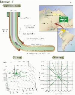
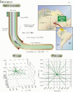
The extended-reach horizontal wells (Fig. 1) have three hole sections, as follows:
For the 12-24 wells/pad, Sincor uses a batch-drilling strategy that consists of drilling all the 16-in. hole sections for a particular pad, followed by all the 121/4-in. build sections, and then finally all the 81/2-in. laterals.
Batch drilling reduces the job to a series of short and repetitive cycles that become familiar to the rig crew and supervisors, thus improving operational efficiency.
Currently, completion of the sections is averaging:
- Two days for the 121/4-in. build sections, including drilling, running casing, cementing, and skidding rig.
- Three to four days for the 81/2-in. lateral sections, including drilling, running liner, and skidding rig.
Typically, Sincor has four to five rigs drilling at any time. With all rigs running, a new horizontal well is completed about every 11/2 days.
Planning stage
At the planning stage, two processes are in place that help improve efficiency, in the traditionally labor-intensive task of generating an approved well-construction plan.
The first process in the prewell stage, which improves integration between the multidiscipline team members, is called collaborative well planning. Geoscientists start the process by generating a provisional well path generated from the earth model in the UNIX environment using Landmark Graphics software Wellbore Planned.
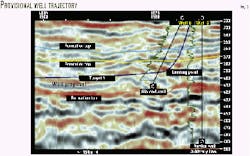
The targets are directly on the seismic plane in depth, and the provisional trajectory is obtained by visually intersecting the favorable reflectors or sweet spots on this seismic plane (Fig. 2). The provisional well path is then accessed and brought into the Windows NT environment by the well planning engineers with Landmark Graphics Compass software.
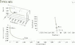
Transfer of coordinates can be facilitated by a link from Compass, which allows direct access to the UNIX system. In Compass, the provisional well path is optimized for drilling engineering criteria such as build-rate restrictions, torque and drag limitations, and anticollision analysis (Fig. 3).
Once the well path is optimized, it is reimported into Wellbore Planned where the adjusted trajectory is reverified against the earth model. If all target criteria are met, then the plan is approved and posted on the intranet. If there are discrepancies, then the loop starts again until both the geoscience and drilling engineering teams are satisfied.
This workflow process improves well planning efficiency when compared with more-traditional planning methods. This efficiency is necessary, particularly when batch drilling 121/4-in. build sections, which take less than 48 hr to drill, case, cement, and skid the rig.
Interactive drilling
The interactive drilling program keeps up with the rapid pace that the project demands by allowing interaction between the different teams involved in the drilling. The teams include drilling engineering, geoscience, mud-cementing, and directional drilling engineering.
The program consists of individual spreadsheets linked to a central file that summarizes all inputs. Every team member can modify its sheet as required and can access the other sheets if necessary.
The program is easily placed on the network or intranet. Such placement facilitates fast responses to program changes by all teams.
The ease of use of the interactive drilling program allows last minute edits to the drilling program. These edits are necessary when wells are rapidly drilled and where adjustments are constantly being made on proposed well paths based on updated earth models and information from the previously drilled wells from the respective pads.
Network
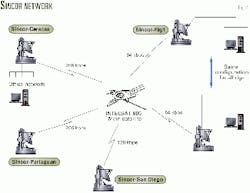
A major component of the planning and monitoring systems is the transfer and sharing of information between different team members at multiple locations. The Sincor Network has been established to facilitate this.
Each active drilling rig has a 64 kilobits/sec (kbps) data rate available for a real-time data transfer, e-mail, intranet connection, and internet access. The telephone and telefax also share this bandwidth.
Each office, rig, and remote location is networked via the main satellite (Intelsat 805), with 64 kbps available on each rig and 256 kbps available in the main Caracas office. Two additional field locations in the network, Pariaguan and San Diego, have 256 kbps and 128 kbps bandwidth access, respectively (Fig. 4).
All locations have full network, intranet, and internet access. Intranet access also is possible by dialing in from any remote location with preassigned security passwords. This access allows members of the multidiscipline teams to view the well information and plans, 24 hr/day, while at home or remotely from the operational offices.
Information available on the intranet includes well-survey proposals, well-drilling programs, daily drilling reports, real-time window summarizing all current well activities and current drilling parameters, seismic cross sections with real-time updated well paths and logs, measured depth and true vertical depth logs, and ASCII files of LWD and survey information.
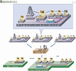
Sperry-Sun Drilling Services' INSITE system provides the project with real-time monitoring capability. This system is a Windows NT-based data acquisition and management system, which acquires all LWD and surface parameter data at the rig site on the rig server. This setup facilitates data replication to a secondary server in the Caracas office. Rig-server to secondary-server replication takes place only as updates or edits occur, resulting in minimal bandwidth utilization.
At each rig site, active sensors acquire the data. LWD sensors include directional measurements of inclination and azimuth, gamma ray, and resistivity. Surface drilling parameter sensors include pump rate, standpipe pressure, surface rotary speed, surface torque, and hook-load.
Downhole drilling efficiency sensors include drillstring vibration sensors and pressure-while-drilling (PWD) tools. The PWD tools measure annular and bore pressures that enable the calculation of real-time downhole equivalent circulating densities (ECDs).
At each rig site, the information is acquired and stored in the rig server's database. The company man, wellsite engineer, and wellsite geologist have rig-site workstations that can access the rig server via the rig local area network (LAN), allowing well monitoring from their respective rig offices (Fig. 5).
The rig server also replicates its database to a secondary server in Sincor's main geoscience and drilling engineering decision center in Caracas. Each rig drilling and transmitting real-time data has an assigned secondary server in Caracas.
Members of the multidiscipline teams can access the local database on each secondary server via the office LAN. This access allows well monitoring from different workstations within the office.
Geoscience
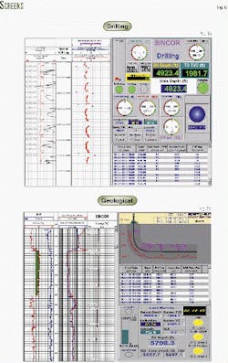
Standard log plots are available directly from the rig or from secondary servers for rapid log correlations (Fig. 6). LWD and survey data from each secondary server in Caracas are loaded automatically into the Openworks database where the earth model resides.
By using the INSITE-to-Openworks (IOW) link, the system can update the data at any desired time or depth interval. In Sincor's model, data from each of the secondary servers (Windows NT-based systems) is passed directly into the appropriate Openworks project in the UNIX environment. On each secondary server, Openworks NT is installed in client mode, allowing access to the main UNIX Openworks database.
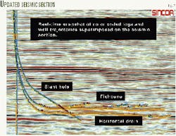
Once the data are in the earth model, the most practical tool for visualization is to display the gamma ray and resistivity log curves along the actual well trajectory on a depth-based seismic cross section. The proposed well path should also be superimposed on this section.
Both gamma ray and resistivity curves are color coded according to predefined cut-offs. Cut-offs on the gamma ray give a quick visualization of sand and shale, while cut-offs on the resistivity curves give information on the fluid content of the drilled formations.
The rapid drill rates dictate that data be transferred to the earth model every 2 min via INSITE-to-Openworks. The system subsequently computes six curves from this imported data using the specific cut-off values for the gamma ray and resistivity.
Every 3-4 min, the system loads these curves for each well into the Openwork database. Then, along with an updated trajectory, the data are projected onto a selected seismic cross section generated using Landmark Graphics Stratworks software.
For each well, the system takes a snapshot of the updated seismic display with logs and trajectories at 4 min intervals and posts it to the intranet (Fig. 7). This procedure allows the multidiscipline team members visually to monitor a rapidly drilled horizontal well and to view complex ideas across the network.
The expert members of the multidiscipline teams can make faster and more informed decisions with the real-time monitoring of LWD and survey information and by comparing this to the earth model and predefined well path. These decisions allow redefinition of the optimum well trajectories while drilling and thus help ensure a maximum pay zone in a well.
The capability to monitor and compare real-time also allows other critical decisions to be performed more efficiently, leading to better decisions and considerable time savings. These decisions include casing-point definition, navigation corridors, and openhole sidetrack determination.
The real-time update of data into the earth model also promotes expedient redesign of future wells in the batch-drilling program. Real-time updates dispense with waiting to receive and import appropriate LWD curves when needed to update or verify an earth model.
Drilling engineering
Acquisition and distribution of real-time drilling data also have improved operational efficiency. During drilling of extended lateral sections, the monitoring of equivalent circulating density (ECD) downhole with the pressure-while-drilling sensor is helping to ensure better hole cleaning and to reduce the risk of either differential sticking or packing-off.
Engineers at the rig sites and in Caracas can monitor the same information and come to a joint decision as to when to short trip or circulate the well clean. Optimization of these decisions saves time and avoids potential hole problems.
Drillstring vibration sensors have monitored downhole vibrations. The effects of changing drilling parameters on downhole vibration can be monitored with visual warning displays set up on the rig floor and in the office. If excessive vibration is encountered, then alarms are activated and recommended changes to the drilling parameters are displayed.
Reduced downhole vibration has extended downhole tool life and reduced time-consuming trips to change out equipment.
Surface-drilling parameter data such as pump rate, standpipe pressure, surface rotary speed, surface torque, and hook-load are used to monitor and optimize processes both while drilling and while running liner.
The push to avoid having to trip to rearrange weight components of the drillstring through the lateral section has been partially achieved by carefully monitoring surface parameters in conjunction with downhole ECD, which indicates the amount of hole cleaning.
By the careful monitoring of actual data vs. theoretical torque-and-drag models, real-time updates of the models have resulted in optimized procedures and drillstring configurations. This has enabled the lateral sections to be drilled in a single run without rearranging the drillstring, thus saving much time.
The system automatically posts all drilling engineering data to the web page for distribution through the intranet with updates every 3 sec. The benefit of having drilling engineering information available in multiple locations is the ability to call upon more experts to ensure maximum optimization of the well engineering process.
Experts do not have to be in the field and can overview multiple wells simultaneously.
Human resources
At the rig site, all associated LWD and survey data quality-control procedures are followed.
The LWD engineer initiates the real-time transfer of this information to Caracas. Because the LWD engineers work rotational shifts providing 24-hr coverage, no additional manpower is required at the rig site to operate the real-time network.
In the Caracas office, 24-hr coverage is also necessary to monitor the secondary servers receiving data from the rig servers and to ensure that the flow of data is current to the earth model. The system is stable; however, operator input is required for such procedures as changing well names with openhole sidetracks and to re-initialize the INSITE-to-Openwork link.
The 24-hr Caracas office support consists of two engineers working 12-hr shifts. These engineers provide a secondary well planning role, redefining well trajectories if required. At present, provision for the office support engineers is included in the directional drilling/LWD contract.
A single Sincor data manager performs intranet maintenance and Openworks database management. The roles and responsibilities of both the office and field-based technical team members have evolved to integrate the real-time processes.
The traditional barriers of information exchange between the office and wellsite no longer exist. For example, this allows office-based geophysicists to work with real-time LWD data and wellsite geologists and directional drillers to expedite any recommended trajectory changes.
Future plans
Sincor may install a 3D "visionarium" center to monitor and plan future wells. This will further enhance collaboration between the technical teams in Caracas.
This new facility will also allow more complete drilling, reservoir engineering, and complex geological modeling that will be integrated into the planning and real-time decision making processes.
The authors
Guillermo A. Capacho is country manager for Sperry-Sun Venezuela in Maturin, Venezuela. He has extensive experience in directional and multilateral drilling. Capacho has a degree in petroleum engineering from the Universidad Industrial De Santander, Bucaramanga, Colombia.
Tore Larsen is the well technology and operations manager for Sincor. He previously worked for Ocean Drilling & Exploration Co., Moran Bros. Intl., and as an independent consultant before joining Statoil. Larsen has an MS in mechanical engineering.
Jean L. Lavillonniere is data manager for the production division of Sincor. He previously was responsible for the administration and production computer systems for Total in Paris. Lavillonniere has masters degrees in economics, statistics, and computer sciences.
Yves Kremer is a geophysicists with Sincor. He previously worked for TotalFinaElf in various countries. Kremer has a Doctor's degree in applied Geophysics.
