Soil gas survey detects microseepage through thick evaporitic sequence in Egypt
A surface geochemical exploration survey in eastern Egypt detected hydrocarbon microseepage from reservoirs overlain by 8,000 ft of evaporitic salt and anhydrite sequences with interbeds of shale.
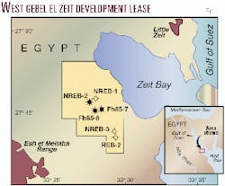
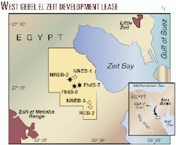
Forum Exploration completed the survey on the West Gebel El Zeit Development Lease about 10 km west of Zeit Bay and Ras El Bahar fields near the southern end of the Gulf of Suez.
The study area has proven oil and gas reserves in the Miocene Kareem and Rudeis sandstone formations. The hydrocarbon-bearing reservoirs are overlain by about 8,000 ft of evaporitic salt and anhydrite sequences with interbeds of shale.
The objective of this surface geochemical survey was to test the capability of the survey in detecting and modeling hydrocarbon microseepage from deep reservoirs that are overlain by thick evaporitic sequences. Many exploration professionals believe that massive salt bodies possess sealing capabilities that prevent microseepage of hydrocarbons to the earth's surface.
In addition to the soil gas collectors placed in the area under investigation, collectors were placed around two oil-bearing wells and near a dry hole. The near-surface soil gas data collected from the model samples were used to develop a statistical model that describes the difference between the reservoir hydrocarbon emanations and those associated with background geochemical character.
Based on a rigorous statistical analysis, several geochemical anomalies were identified that were similar to the reservoir hydrocarbon model. These anomalies match the geological information and existing well data from this area.
The positive results of the survey were further confirmed by the completion of a new producing oil well. The well was drilled after the surface geochemical survey was completed, but the well location was chosen before any geochemical data were acquired and wellsite selection was based solely on seismic data.
The results of the surface exploration survey indicate clearly that the sealing capabilities of thick sequences of salt and anhydrite are insufficient to prevent hydrocarbon microseepage to the surface from deep petroleum reserves.
Introduction
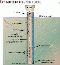
In early 1999, Forum Exploration and W.L. Gore & Associates, with permission from Egyptian General Petroleum Corp., conducted a surface geochemical survey on the West Gebel El Zeit Development Lease using the Gore-Sorber Exploration Survey (Fig. 1).
Conventional wisdom among petroleum explorationists is that massive salt bodies possess sealing capabilities virtually unmatched by other lithological materials. This belief, as applied to the entrapment of liquid and gas hydrocarbons, leaves many industry professionals convinced that massive salt bodies are a barrier to hydrocarbon microseepage from a reservoir to the earth's surface. Therefore the objective of the Gore-Sorber Exploration Survey was to demonstrate its abilities in detecting hydrocarbon microseepage from deep reserves through thick evaporitic salt sequences.
Surface geochemical exploration techniques have existed since the early 1900s and have a long history of success in petroleum exploration. Acceptance of surface geochemical techniques has increased substantially in recent years due to significant technological developments in soil gas sampling systems and in advanced geochemical modeling techniques.
Further, empirical evidence and research have provided detailed information on the concept and principle of microseepage and vertical migration of hydrocarbons from deep reserves.1-5
Stratigraphy, geologic structure
A common problem in the southern part of the Gulf of Suez rift basin is the delineation of the Kareem and Lower Rudeis reservoir sand formation merging with the growth fault system. The rapid sedimentary facies variation across the different fault blocks is a common feature in the West Gebel El Zeit concession. Proper delineation of the formation is of paramount importance in planning the field development.
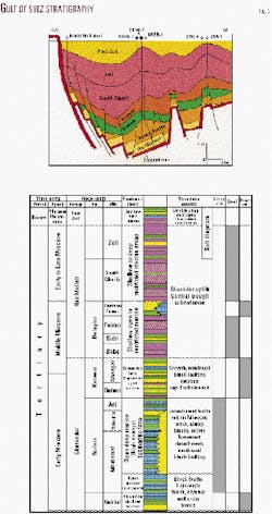
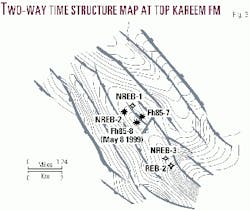
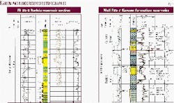
The stratigraphy of West Gebel El Zeit field is similar to that of the general stratigraphy in the Gulf of Suez region (Fig. 2). The structural configuration of the studied area is illustrated in Figs. 3 and 4. Lithologies of the various stratigraphic members overlying the deepest reservoir target that are of most significance to this study are described below.
In the survey area, the Pliocene and Pleistocene-age Post Zeit sedimentary section consists of 500 ft of loose sand and conglomerate with interbeds of gypsum, anhydrite, and bioclastic limestone. Underlying this, the Zeit formation comprises 3,500 ft of anhydrite with some interbeds of salt, shale and sandstone streaks.
The South Gharib formation measures 3,600 ft in thickness and consists of massive salt bodies with thin interbeds of shale and anhydrite. The Belayim formation includes four distinct members, two of which are evaporitic sections represented by the Feiran and Baba members and the other two are mainly clastic sections represented by the Hammam Faraun and Sidri members, which are made up of shales with limestone and sandstone interbeds.
The Kareem formation is subdivided into two members totaling about 1,000 ft in thickness. The upper member (Shagar member) is composed of a gradational sequence of interbeded calcareous shale and argillaceous limestone grading into marl with good quality sandstone interbeds at the base of the member. The lower member (Rahmi member) is composed of marl, calcareous shale, limestone, and sandstone interbeds at the top of this member. A marker anhydrite bed separates the upper and lower members.
Finally, the Rudeis formation measures 2,400 ft in thickness and is composed of interbeds of shale, fractured limestone, and highly calcareous sandstone. The Miocene-age Kareem and Rudeis formations are the primary hydrocarbon targets in West Gebel El Zeit field and include good quality sandstone reservoirs that were laid down in depositional settings ranging from fluvial to submarine fans (Fig. 4).
Gore approached the operator of the concession and presented the application of its soil gas survey as a robust method to gain additional data with regard to the presence and location of hydrocarbons as a result of microseepage to the earth's surface.
A new seismic program and high-resolution magnetic interpretation was implemented during preparation of the surface geochemical survey. At the conclusion of the data gathering activities, an excellent match was observed between the surface geochemical results and the seismic interpretation.
Surface exploration survey
The patented Gore-Sorber Module contains passive, vapor-phase sampling devices called sorbers (Fig. 5). Each sorber contains an adsorbent media which collects hydrocarbons present in the soil gas. Specialized sorbents are utilized which minimize the uptake of water vapor-a critical requirement given that water vapor is a significant constituent of most soil environments.
The sorbers are housed in one end of a narrow diameter insertion and retrieval cord. Both the cord and the sorbers are constructed of a chemically-inert, microporous, vapor-permeable membrane (expanded polytetrafluoroethylene, ePTFE).
A unique feature of the membrane is its ability to repel water (hydrophobicity) while allowing vapors to pass through the membrane unimpeded. Liquid water and soil particulates are prevented from contacting the sorbents. Each module contains replicate sorbers for repeat analysis if required.
Survey design
The survey program was conducted during January and February 1999. The West Gebel El Zeit concession covers 46 sq km, of which 35 sq km were sampled for soil gas.
A total of 100 Gore-Sorber modules were installed over the lease along four primary transects, trending in a northeast-southwest direction, and spaced approximately 900 m apart. Two additional transects, trending in a northwest-southeast direction, oriented perpendicular to the first four transects, were also installed. The modules were placed at 250 and 500-m spacings.
The field sampling included the placement of several collectors in areas known to produce oil as well as in a nonproductive area for geochemical modeling purposes.
Twenty modules were installed at the locations of two producing oil wells, NREB-2 and Fh85-7. Another ten modules were located at a relatively shallow dry well, REB-2. This well is 550 m southeast of and updip from another dry well, NREB-3, which penetrated the full sedimentary sequence.
The hydrocarbon presence in the soil gas data reported from the model samples provided the necessary hydrocarbon signatures to develop a geochemical model that differentiates hydrocarbon presence from that of background.
Module locations and coordinate information were recorded using portable global positioning systems. The samples were installed to a depth of 2 ft in narrow diameter, uncased holes, drilled using an electric rotary hammer drill.
The modules were left exposed to the near-surface soil gas for approximately 17 days. Additional modules were shipped and treated as trip blanks to record and document any potential ambient effects during the field survey.
Sample analysis
Following the field exposure, the modules were retrieved and returned to the Gore laboratory for analysis. All soil gas samples from this survey were analyzed by thermal desorption followed by gas chromatographic separation and mass selective detection (TD/GC/MS).
Rigorous quality assurance and quality control support data validity. Data analysis included positive identification of more than 70 target compounds in the range of C2 through C18.
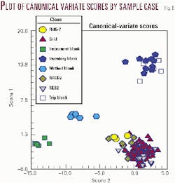
A statistical comparison of the soil gas data and the data reported from the QA samples revealed distinct chemical signature differences (Fig. 6). This analysis indicated that the field samples acquired a new geochemical imprint during field exposure and were therefore suitable for use in subsequent processing and geochemical modeling.
Geochemical modeling
Hydrocarbon compounds exist naturally in the soil gas in areas where subsurface hydrocarbon accumulations are not present. The geochemical variations in soil gas data that distinguish subsurface hydrocarbons from surface sources of hydrocarbons are often subtle and difficult to identify. Therefore, data derived from the analysis of soil gas samples are processed using advanced multivariate statistical methods.
The fundamental objective of the geochemical modeling and data interpretation is to identify areas of hydrocarbon emanation that indicate potential subsurface hydrocarbon accumulations. The geochemical modeling process defines the character of both hydrocarbon and background soil gas signatures. As noted above, the modeling is accomplished by placing a series of modules in areas of known petroleum production and nonproduction areas.
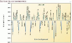
A significant assumption of the geochemical modeling method is that the soil gas signature in the vicinity of a producing well represents accurately and consistently the surface expression of the subsurface hydrocarbon accumulation. The derived geochemical model revealed the most significant target compounds that were indicative of oil-like and background signatures (Fig. 7).
Following the geochemical model development, all field modules deployed throughout the survey area were compared with the model. The probability values quantified the similarity between the field sample and oil-like signature defined by the two oil model wells.
Probability histograms were compiled, and a value of 72% was identified as an anomalous threshold. Module locations having probability values exceeding 72% were considered indicative of hydrocarbon accumulation at depth. Locations where the probability values were tending towards zero were considered indicative of background and suggested a lack of hydrocarbon accumulation.
Results
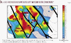
The surface geochemical results of this study were confirmed by a new oil well, Fh85-8, drilled in May 1999 following the geochemical survey (Fig. 8). All of the anomalous features identified show a general northwest-southeast trend, parallel to the faulting direction in the study area.
The main petroliferous block identified by the surface geochemistry is located at the center of the survey area and is trending in a northwest-southeast direction. The structure at the top of the Kareem formation is well represented in this block and encompasses two oil-bearing wells, NREB-2 and Fh85-8. The latter well was completed and produced oil at a rate of 800 b/d two months after the geochemical survey.
Immediately to the northeast of the main petroliferous block, a geochemical negative area was observed. This negative block encompasses both the dry well NREB-1 and the producing well Fh85-7. Although well Fh85-7 is located in a geochemical negative area, this well actually produces oil from the Rudeis sands located across the fault in the main petroliferous block, due to deviation of the wellbore to the west.
The other structural blocks identified during the seismic interpretation appear to have a high probability of hydrocarbon presence as indicated by presence of additional positive geochemical anomalies and will be subject to future investigation.
Acknowledgments
The authors express gratitude to the management of Forum Exploration and Oasis Petroleum Co. for their strong support and thoughtful discussion in conducting this unique pilot survey. Miran Co. and Oasis provided the field services and facilities. We acknowledge Egyptian General Petroleum Corp. for granting permission to publish this research.
References
- Coleman, D.D., Meents, W.F., Liu, C.L., and Keogh, R.A., "Isotopic identification of leakage gas from underground storage reservoirs-a progress report," Illinois State Geological Survey, Report 111, 1977, p.10.
- Horvitz, L., "Hydrocarbon geochemical prospecting after 30 years," in "Unconventional methods in exploration for petroleum and natural gas," Heroy, W.B., ed., Southern Methodist University Press, Dallas, 1969, pp. 205-218.
- Klusman, R.W., and Saeed, M.A., "Comparison of light hydrocarbon microseepage mechanisms," in "Hydrocarbon migration and its near-surface expression," Schumacher, D., and Abrams, M.A., eds., AAPG Memoir 66, 1996, pp. 157-168.
- MacElvain, R., "Mechanics of gaseous ascension through a sedimentary column," in "Unconventional methods in exploration for petroleum and natural gas," Heroy, W.B., ed., Southern Methodist University Press, Dallas, 1969, pp. 15-28.
- Potter, R.W. II, Harrington, P.A., Silliman, A.H., and Viellenave, J.H., "Significance of geochemical anomalies in hydrocarbon exploration: one company's experience," in "Hydrocarbon migration and its near-surface expression," Schumacher, D., and Abrams, M.A., eds., AAPG Memoir 66, 1996, pp. 431-439.
Bibliography
Wrigley, M.J., and Silliman, A.H., "Report of Findings, Gore-Sorber Exploration Survey, West Gebel El Zeit Development Lease, Egypt," report issued to Forum Exploration, Cairo, Egypt, April 1999.
Gevirtz, J.L., and Vargo, J.M., "Mitigation of drilling risk with near-surface hydrocarbon detection, a case study: Gulf of Suez, Egypt," APGE Bull. 9, December 1993, pp. 1-31.
The authors
Sherif El Bishlawy is exploration general manager of INA-Naftaplin Egypt branch. He has more than 37 years in the oil industry in Egypt and the gulf. He received a BSc degree in geology and mineralogy from Cairo University and an MSc degree in sedimentary geology and mineralogy from Ein Shams University. E-mail: [email protected]
Adel Sehim is an associate professor of structural geology at Cairo University and a petroleum consultant with 12 years' experience in Egypt. E-mail: [email protected]
Mohamed El Sabbagh is an exploration general manager and board member of OAPCO, Egypt, with 24 years' experience in Egypt's oil industry. He has a BSc degree in geology from Tanta University and a diploma in applied petroleum geology from Ein Shams University.
Mohamed Habo is an operations manager geologist with MIRAN for Development & Foreign Trade in Alexandria. He specializes in surface geochemical exploration, petroleum geology, and organic chemistry. He holds a BS degree in geology from Tanta University and an MS in geology from the University of Berlin.
Jay W. Hodny is a project manager and scientist at W.L. Gore & Associates Inc. He specializes in GIS and computer mapping of soil gas data for environmental and exploration soil gas surveys. He holds an MS degree in geography and a PhD degree in climatology from the University of Delaware. E-mail: [email protected]
Mark Wrigley is a professional geologist and project manager with Gore specializing in the processing and modeling of surface geochemical data in exploration applications. He holds a BSc degree in geology from the University of Durham. E-mail: [email protected]
Holger Stolpmann is sales manager for Gore in the Middle East and Europe. He managed passive soil gas surveys for environmental and exploration for 5 years and has several years' experience in remediation of sites contaminated with explosive compounds. He holds MS and PhD degrees in chemistry from the University of Munich. E-mail: [email protected]
